|
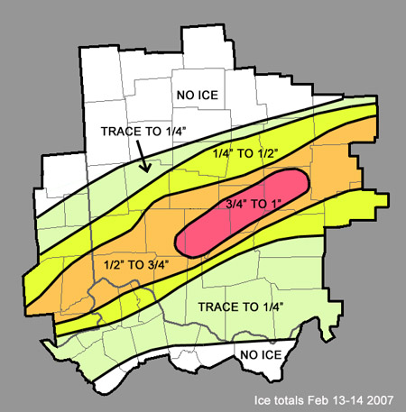
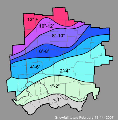
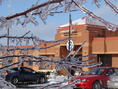
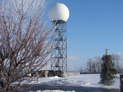
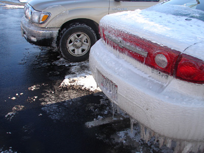
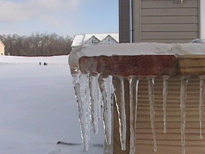
Winter Storm An intense winter storm developed over the Southern Plains and moved across the Ohio Valley on Tuesday, February 13, 2007. Widespread rain developed ahead of the storm late on Monday February 12. The moisture moved into colder air as it crossed into northern Kentucky, southern Indiana and Ohio early on Tuesday. This caused the rain to change to snow, and dropped anywhere from 1 to 5 inches of snow on much of the region by daybreak Tuesday. As the storm intensified, it drew in warmer air from the south, which caused the snow to quickly change to sleet and freezing rain Tuesday morning and afternoon across much of the I-70 corridor and points south. Areas from Dayton to Columbus received several inches of sleet on top of the snow, which later turned into freezing rain with up to a quarter inch of ice on trees and power lines. Further south, snow had quickly changed to freezing rain Tuesday morning. This included areas from the northern Cincinnati suburbs into Wilmington and areas south of Columbus. The temperature never warmed above freezing across these areas, which allowed ice to accumulate to between a half inch and an inch. This resulted in significant tree damage and numerous power outages. Southern portions of Cincinnati and far northern Kentucky saw temperatures warm to near or slightly above freezing which alleviated some of the icing, but still allowed up to a quarter of an inch of ice accumulation and several downed tree limbs and power lines. Further north, the intensifying storm caused the pressure gradient to tighten across western and northern Ohio and resulted in very strong winds with gusts up to 45 mph. This caused significant blowing and drifting of snow across areas from Troy to Marysville, and further north into Celina, Wapakoneta and Bellefontaine. As a result, road crews had a very difficult time keeping roads clear, and by Tuesday afternoon, travel across west central Ohio was nearly impossible. By Tuesday evening, a level 3 snow emergency had been declared in many counties in west central Ohio. The snow continued late Tuesday night, and by Wednesday morning had accumulated to anywhere from 8 to 15 inches. The wind caused snow to drift substantially, and in some cases drifts were over 4 feet high. |
PUBLIC INFORMATION STATEMENT
SPOTTER REPORTS
NATIONAL WEATHER SERVICE WILMINGTON OH
236 PM EST WED FEB 14 2007

THE FOLLOWING ARE UNOFFICIAL OBSERVATIONS TAKEN DURING THE PAST 24 HOURS
FOR THE STORM THAT HAS BEEN AFFECTING OUR REGION.  APPRECIATION IS EXTENDED
TO HIGHWAY DEPARTMENTS...COOPERATIVE OBSERVERS...SKYWARN SPOTTERS
AND MEDIA FOR THESE REPORTS.  THIS SUMMARY IS ALSO AVAILABLE ON OUR
HOME PAGE AT WEATHER.GOV/ILN

********************STORM TOTAL SNOWFALL********************

LOCATION          STORM TOTAL    TIME/DATE    COMMENTS
                     SNOWFALL       OF
                     (INCHES)   MEASUREMENT


INDIANA

...FAYETTE COUNTY...
   ALPINE                 5.0   800 AM  2/14   COOP OBSERVATION

...FRANKLIN COUNTY...
   BROOKVILLE             5.3   800 AM  2/14   COOP OBSERVATION

KENTUCKY

...GALLATIN COUNTY...
   NAPOLEON               1.5   800 AM  2/14

...KENTON COUNTY...
   COVINGTON              1.6   800 AM  2/14   NRN KY INTL AIRPORT

...OWEN COUNTY...
   OWENTON                  T   900 AM  2/14

OHIO

...ADAMS COUNTY...
   ADAMS COUNTY           2.0   856 AM  2/14   ODOT GARAGE
   WEST UNION             1.4   221 PM  2/14   COOP OBSERVATION

...AUGLAIZE COUNTY...
   NEW BREMEN            12.0  1219 PM  2/14   AUGLAIZE COUNTY EMA
   SAINT MARYS           12.0  1219 PM  2/14   AUGLAIZE COUNTY EMA
   AUGLAIZE COUNTY       10.0   948 AM  2/14   ODOT GARAGE

...BROWN COUNTY...
   BROWN COUNTY           1.0  1045 AM  2/14   ODOT GARAGE

...CHAMPAIGN COUNTY...
   CHAMPAIGN COUNTY       8.0   940 AM  2/14   ODOT GARAGE

...CLARK COUNTY...
   SPRINGFIELD            8.5   744 AM  2/14
   NEW CARLISLE           5.0   800 AM  2/14

...CLERMONT COUNTY...
   MULBERRY               0.5   841 AM  2/14

...CLINTON COUNTY...
   WILMINGTON             2.6   800 AM  2/14   NWS OFFICE

...DARKE COUNTY...
   DARKE COUNTY          11.0  1043 AM  2/14   ODOT GARAGE
   VERSAILLES            10.0   800 AM  2/14

...DELAWARE COUNTY...
   DELAWARE               8.0   953 AM  2/14   ODOT GARAGE

...FAIRFIELD COUNTY...
   FAIRFIELD COUNTY       2.5   949 AM  2/14   ODOT GARAGE

...FAYETTE COUNTY...
   WASHINGTON COURT       3.0   800 AM  2/14   COOP OBSERVATION
   FAYETTE COUNTY         2.5   900 AM  2/14   ODOT GARAGE

...FRANKLIN COUNTY...
   COLUMBUS               5.9   800 AM  2/14   PORT COLUMBUS INTL ARPT
   FRANKLIN COUNTY        4.8   953 AM  2/14   ODOT GARAGE

...GREENE COUNTY...
   GREENE COUNTY          7.0  1000 AM  2/14   ODOT GARAGE

...HAMILTON COUNTY...
   CINCINNATI             3.6   818 AM  2/14   5 NW CINCINNATI

...HARDIN COUNTY...
   KENTON                13.0   852 AM  2/14
   HARDIN COUNTY         11.0   831 AM  2/14   ODOT GARAGE

...HIGHLAND COUNTY...
   HILLSBORO              2.0   800 AM  2/14   COOP OBSERVATION

...HOCKING COUNTY...
   LAURELVILLE            2.0   800 AM  2/14   COOP OBSERVATION

...LICKING COUNTY...
   HEBRON                 6.5   800 AM  2/14   BUCKEYE LAKE COOP OB
   NEWARK                 5.0   800 AM  2/14   COOP OBSERVATION

...LOGAN COUNTY...
   BELLEFONTAINE         13.0   800 AM  2/14   COOP OBSERVATION
   LOGAN COUNTY           8.0   952 AM  2/14   ODOT GARAGE
   HUNTSVILLE             7.5   800 PM  2/14   COOP OBSERVATION

...MADISON COUNTY...
   MADISON COUNTY         8.5   734 AM  2/14   ODOT GARAGE

...MERCER COUNTY...
   MERCER                10.0   751 AM  2/14   ODOT GARAGE

...MIAMI COUNTY...
   TROY                  10.5  1123 AM  2/14   SOME DRIFTING
   BRADFORD               8.0   900 AM  2/14
   MIAMI COUNTY           6.0   744 AM  2/14   ODOT GARAGE

...MONTGOMERY COUNTY...
   VANDALIA               5.3   800 AM  2/14   DAYTON INTL AIRPORT

...PICKAWAY COUNTY...
   CIRCLEVILLE            5.0   800 AM  2/14   COOP OBSERVATION
   PICKAWAY COUNTY        4.0   918 AM  2/14   ODOT GARAGE

...PIKE COUNTY...
   PIKE COUNTY            2.0   801 AM  2/14   ODOT GARAGE

...PREBLE COUNTY...
   PREBLE COUNTY          7.0   614 AM  2/14   ODOT GARAGE

...ROSS COUNTY...
   ROSS COUNTY            2.0   722 AM  2/14   ODOT GARAGE

...SCIOTO COUNTY...
   SCIOTO COUNTY          1.0   759 AM  2/14   ODOT GARAGE
   SCIOTOVILLE              T   800 AM  2/14

...SHELBY COUNTY...
   SHELBY COUNTY          9.0  1000 AM  2/14   ODOT GARAGE

...UNION COUNTY...
   UNION COUNTY          13.0   848 AM  2/14   ODOT GARAGE
   MARYSVILLE            11.0   800 AM  2/14   COOP OBSERVATION

...WARREN COUNTY...
   KINGS MILLS            3.3   800 AM  2/14   COOP OBSERVATION
   WARREN COUNTY          2.0   620 AM  2/14   ODOT GARAGE

***********************STORM TOTAL ICE***********************

LOCATION          STORM TOTAL    TIME/DATE    COMMENTS
                          ICE       OF
                     (INCHES)   MEASUREMENT


INDIANA

...DEARBORN COUNTY...
   AURORA                0.70   925 PM  2/13

KENTUCKY

...BOONE COUNTY...
   FLORENCE              0.70   810 PM  2/13

...OWEN COUNTY...
   OWENTON               0.10   900 AM  2/14

OHIO

...CLERMONT COUNTY...
   MULBERRY              0.10   841 AM  2/14

...CLINTON COUNTY...
   WILMINGTON            0.90   800 AM  2/14   NWS OFFICE

...FRANKLIN COUNTY...
   COLUMBUS              0.50   920 PM  2/13   SOUTH SIDE COLUMBUS

...HAMILTON COUNTY...
   CINCINNATI            0.80   818 AM  2/14   5 NW CINCINNATI

...LICKING COUNTY...
   NEWARK                0.50   845 AM  2/14

...SCIOTO COUNTY...
   SCIOTOVILLE           0.10   800 AM  2/14

$$
|
| Ice Totals | Snow Totals |
|
|
| NWS office (2 S Wilmington, Ohio) | ||
|
|
|
|
Near US-22 and Webb Road (3 W Wilmington, Ohio) |
|

