|
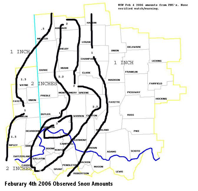
Winter Weather Event Review Section 1: Introduction Section 1 -- Section 2 -- Section 3 -- Section 4 -- Section 5 -- Section 6 On February 4, 2006, a storm system affecting the Ohio Valley produced widespread precipitation across the entire Wilmington, OH (ILN) County Warning Area (CWA). The precipitation began as rain during the pre-dawn hours and changed to snow in the west during the late morning and by mid afternoon in the far east. Snow amounts ranged from 1 to 3 inches in the west where a quicker change-over occurred, to less than an inch in the east (Fig. 1). This event provided an interesting forecast challenge due to a number of factors including but not limited to the following; model solution differences, timing of precipitation change-over, the affect of ground temperatures on snow accumulation, collaboration issues, HPC guidance changes, warning criteria differences across CWA boundaries, and GPRA lead time goals. This write up will provide a brief overview of the meteorology and challenges faced by the forecasters leading up to this event. An assessment of the major synoptic weather features will be presented in section 2. Numerical model solution trends will be examined in section 3, with a look at the last three synoptic model times leading up to the event. The potential for banded heavier precipitation will be examined in Section 4. Forecast challenges will be discussed in Section 5, with a summary of the event and lessons learned in Section 6.
|