|
Winter Storm A weak low pressure system slowly moved across the Ohio Valley on December 15th. This low worked in tandem with a deepening low pressure center, which moved from the southeast Gulf Coast states to the east coast. The second area of low pressure helped to bring plenty of moisture from the Gulf of America and the Atlantic ocean north into the Ohio Valley. Temperatures in the lower part of the atmosphere made this a difficult storm to forecast as subtle differences in temperatures in the lower 3000 feet can make a difference in what type precipitation falls. The atmosphere was just cold enough that a majority of the precipitation fell as snow from the Whitewater Valley through the Miami Valley into the northern portions of central Ohio. This resulted in 4 to 6 inches of snowfall. |
| Snowfall Amounts: | |||
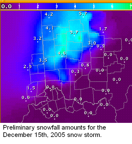 |
Snowfall amounts from December 15, 2005. | ||
| Radar images: | |||
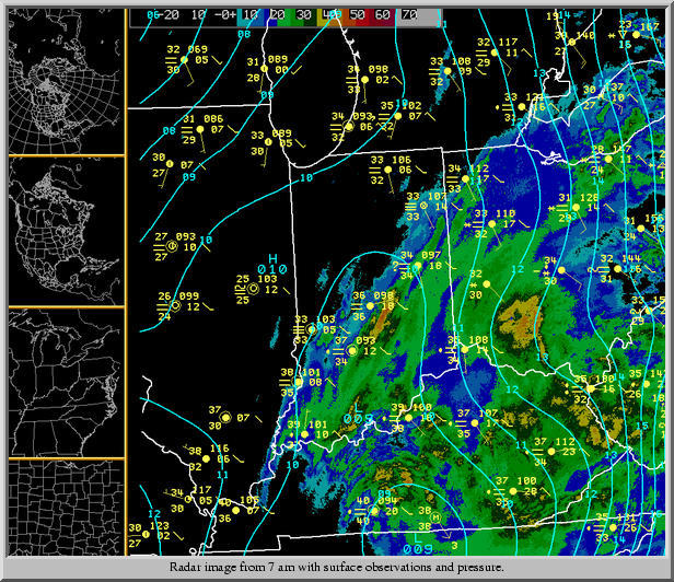 |
Wilmington Doppler radar from 7 am shows precipitation across much of the forecast area. However, it was only cold enough for all snow from the Whitewater valley in east central Indiana to central Ohio north of Columbus. | ||
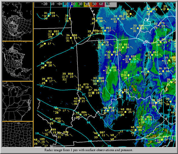 |
Wilmington Doppler radar from 1 pm continues to show precipitation across much of the forecast area. However, it was only cold enough for all snow from the Whitewater valley in east central Indiana to central Ohio north of Columbus. | ||
PUBLIC INFORMATION STATEMENT
SPOTTER REPORTS
NATIONAL WEATHER SERVICE WILMINGTON OH
1252 PM EST FRI DEC 16 2005

THE FOLLOWING ARE UNOFFICIAL OBSERVATIONS TAKEN DURING THE PAST 36 HOURS FOR
THE STORM THAT HAS BEEN AFFECTING OUR REGION.  APPRECIATION IS EXTENDED
TO HIGHWAY DEPARTMENTS...COOPERATIVE OBSERVERS...SKYWARN SPOTTERS AND MEDIA FOR
THESE REPORTS.  THIS SUMMARY IS ALSO AVAILABLE ON OUR HOME PAGE AT
WEATHER.GOV/ILN

********************STORM TOTAL SNOWFALL********************

LOCATION          STORM TOTAL    TIME/DATE    COMMENTS
                     SNOWFALL       OF
                     (INCHES)   MEASUREMENT


INDIANA

...DEARBORN COUNTY...
   BRIGHT                 1.5  1145 AM 12/15

...FAYETTE COUNTY...
   HARRISBURG             4.5   220 PM 12/15
   CONNERSVILLE           3.5   115 PM 12/15

...UNION COUNTY...
   CLIFTON                4.5   225 PM 12/15
   LIBERTY                3.0   115 PM 12/15

...WAYNE COUNTY...
   RICHMOND               3.5  1243 PM 12/15

OHIO

...AUGLAIZE COUNTY...
   WAPAKONETA             4.5  1030 AM 12/15

...BUTLER COUNTY...
   HAMILTON               2.5  1211 PM 12/15

...CHAMPAIGN COUNTY...
   URBANA                 3.5   120 PM 12/15

...CLARK COUNTY...
   SPRINGFIELD            4.5  1120 AM 12/15

...CLERMONT COUNTY...
   BATAVIA                0.5  1126 AM 12/15

...DARKE COUNTY...
   GREENVILLE             4.5   120 PM 12/15

...DELAWARE COUNTY...
   RADNOR                 6.0   540 PM 12/15
   DELAWARE               4.5   118 PM 12/15

...FAYETTE COUNTY...
   WASHINGTON COURT       1.0  1123 AM 12/15

...FRANKLIN COUNTY...
   DUBLIN                 3.0   530 PM 12/15   FROM WCMH CHANNEL 4
   HILLIARD               3.0   539 PM 12/15   FROM WCMH CHANNEL 4
   WORTHINGTON            2.0   311 PM 12/15   AT DON SCOTT AIRPORT
   COLUMBUS               1.5   530 PM 12/15   AT WCMH TV
   GROVE CITY             1.0   309 PM 12/15   AT BOLTON FIELD

...HAMILTON COUNTY...
   HARRISON               0.5  1145 AM 12/15

...HARDIN COUNTY...
   KENTON                 5.5   115 PM 12/15

...HOCKING COUNTY...
   LOGAN                  1.0   935 AM 12/15

...LOGAN COUNTY...
   EAST LIBERTY           5.2  1130 AM 12/15
   BELLEFONTAINE          3.0  1023 AM 12/15

...MADISON COUNTY...
   LONDON                 1.0   806 AM 12/15

...MERCER COUNTY...
   CELINA                 4.0   135 PM 12/15

...MIAMI COUNTY...
   TROY                   5.0   120 PM 12/15
   BRADFORD               2.0   929 AM 12/15

...MONTGOMERY COUNTY...
   BROOKVILLE             4.5   100 PM 12/15
   HUBER HEIGHTS          2.2   938 AM 12/15
   DAYTON                 2.0   901 AM 12/15

...PICKAWAY COUNTY...
   CIRCLEVILLE            0.1   901 AM 12/15

...PREBLE COUNTY...
   EATON                  4.0   110 PM 12/15

...SHELBY COUNTY...
   SIDNEY                 4.5   115 PM 12/15

...UNION COUNTY...
   MARYSVILLE             4.0   923 AM 12/15

$$
|

