Several decades ago, the Ohio Valley and Great Lakes were paralyzed by one of the worst winter storms to ever sweep across the region. Transportation, schools, and businesses were shut down for days. The "Great Blizzard of 1978" dumped vast amounts of snow across the region and caused widespread near-hurricane strength wind gusts that heaped snow into enormous drifts. A legend to those who lived through it, this once-in-a-lifetime storm will always be the standard by which the severities of all future winter storms to hit this region are judged.
This severe blizzard was the result of a relatively rare merger of two distinct upper level waves (one over Texas and one over the Northern Plains) that caused an explosive intensification of
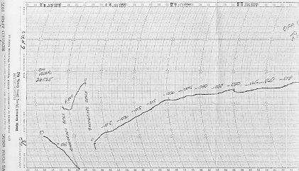
The barograph at the National Weather Service office located at the Greater Cincinnati Airport had to be readjusted as an unprecedented drop in pressure caused the pen to fall off the initial chart scale.
Rain and fog were widespread across the region during the evening hours of January 25, 1978 with temperatures generally in the 30s and 40s. National Weather Service offices across the Great Lakes and Upper Ohio Valley had issued blizzard warnings for most of the region by late evening on January 25th. Early the next morning, an arctic airmass pushed into the area with bitter cold temperatures and howling winds. Blizzard conditions arrived in Cincinnati around 1 AM January 26 and reached Dayton and Columbus within the next couple hours. By 7 AM, blizzard conditions extended all the way to Cleveland. Visibilities were near zero for much of the day and even into the 27th. Temperatures rapidly plunged from the 30s to bitter-cold single digits in just a few hours. Wind gusts averaged 50 to 70 mph for much of the day on the 26th, reaching 69 mph at Dayton and Columbus and 82 mph in Cleveland. An ore carrier stranded in thick ice on Lake Erie just offshore from Sandusky reported sustained winds of 86 mph with gusts to 111 mph that morning! Extremely cold wind chills around minus 50 degrees or lower continued throughout the day, making it especially dangerous to venture outside. While snowfall was difficult to measure due to the strong winds, official storm-total snowfall amounts from January 25-27 ranged from 4.7 inches in Columbus to 6.9 inches in Cincinnati to 12.9 inches in Dayton. Other areas across the region saw well over a foot of snow from the storm.
Large snowdrifts buried these cars in Vandalia, Ohio up to their rooftops and made roadways completely impassable. In northern Ohio and other parts of the region, snowdrifts were tall enough to bury whole semis. Photo courtesy of Special Collections and Archives, Wright State University.
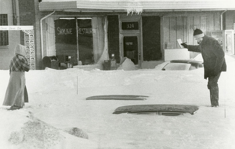
The powerful winds and snow caused major complications across the entire region. Widespread wind damage occurred as thousands of trees and many miles of electric/telephone lines were blown down. As a result, hundreds of thousands of homes were left without power and heat, and many important communication lines were disconnected. Gusty winds also caused numerous other instances of structural damage as well as massive snowdrifts reaching 15 to 25 feet in height. In addition to reaching the rooftops of houses and businesses and causing many roof collapses, these huge drifts brought practically all means of air, rail, and highway transportation to a complete standstill for 24 hours or more. Cars were easily buried and many individuals were left stranded in their vehicles. Numerous closures of interstates and highways resulted, including Interstate 75 which was closed for three days, a portion of Interstate 475 near Toledo which was shut down for six days, and the entire length of the Ohio Turnpike which was closed for the first time in its history. These prolonged highway closures resulted in food shortages in many areas, and the Red Cross and armed forces stepped in to help distribute food to those in need.
Fortunately, the early morning arrival of this severe blizzard prompted officials to close nearly all schools on the 26th, which prevented children from being stranded at school or on buses. In fact, Ohio schools did not reopen until early the following week. President Carter declared a federal disaster in Ohio on the 26th and in Indiana the following day. Meanwhile, area governors activated the National Guard

Where snow-covered roadways made travel by automobile either impractical or impossible, emergency personnel and volunteers utilized snowmobilies to perform rescues and deliveries. In this case, a toboggan was used as a makeshift stretcher. Photo courtesy of Special Collections and Archives, Wright State University
in Ohio, Kentucky, and Indiana. Thousands of men and women on active duty put in many long hours to help clear roadways, restore power, perform emergency rescues and evacuations, deliver food and medicine, and transport medical personnel to hospitals. In many instances, the only means of rescuing individuals with medical emergencies was by helicopter. All across the region, thousands of volunteers with snowmobiles and four-wheel drive vehicles also risked their lives to transport emergency personnel and utility workers and to deliver medical necessities to those in need. Radio stations suspended regular programming to provide storm information and to serve as communication links where other means of communication had failed and highway travel was impossible.
The death toll from this epic winter storm rose to over 70 across the region. This included 5 in Kentucky, 11 in Indiana, and 51 in Ohio. Of the Ohio fatalities, 22 were the result of exposure as individuals abandoned their stranded vehicles or homes with no heat. Thirteen individuals died from the cold while trapped inside their vehicles, and another 13 died inside their homes after losing power and heat. Two others died in buildings that collapsed under the weight of heavy snow. Falls and heart-attacks caused by snow shoveling were among the other causes of death across the region. Fortunately, with so many highways closed, there were no traffic-related deaths in Ohio that weekend. Agricultural losses from the storm totaled around $73 million in Ohio as the result of dead livestock, lost production, property damage, and milk/egg losses. Unable to store or transport milk because of highway closures, farmers were forced to dump the vast majority of milk produced in the days following the blizzard.
To be considered a blizzard, a winter storm must produce sustained winds or frequent gusts greater than 35 mph and be accompanied by falling and/or blowing snow that frequently reduces visibility to less than 1/4 mile for 3 hours or more. Generally, temperatures will be 20 degrees or lower with a blizzard. A severe blizzard is characterized by wind speeds of 45 mph or higher accompanied by a great density of falling and/or blowing snow that frequently reduces visibilities to near zero, along with temperatures generally 10 degrees or lower. The powerful winter storm of 1978 was a severe blizzard.
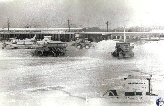
Additional Photos of the Blizzard of 1978
Above photographs all courtesy of Special Collections and Archives, Wright State University

School closures meant
time for fun in the snow |

Venturing out in the bitter cold and blowing snow |

Snow covered cars required lots of effort to clear out |

Peaceful scene from
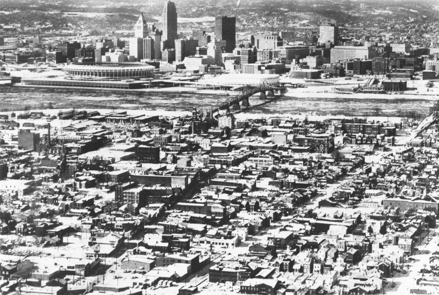
Eden Park in Cincinnati |
|