Marine Weather Message Issued: 07/23/2026 09:47:00 AM UTC
718
WHUS72 KILM 230547
MWWILM
URGENT - MARINE WEATHER MESSAGE
National Weather Service Wilmington NC
147 AM EDT Thu Jul 23 2026
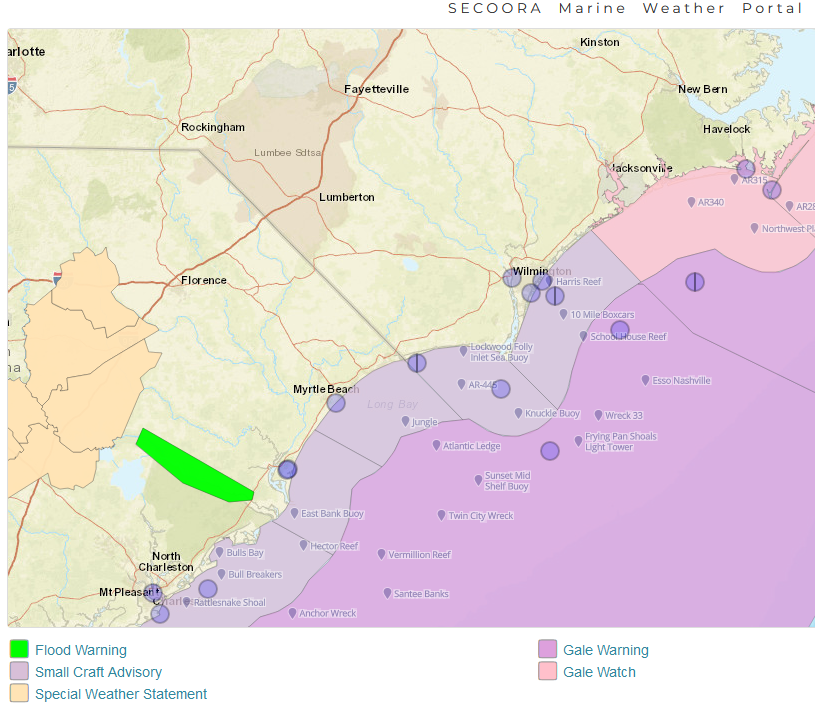
AMZ250-252-254-256-230700-
/O.CAN.KILM.SC.Y.0032.000000T0000Z-260723T1000Z/
Coastal waters from Surf City to Cape Fear NC out 20 nm-
Coastal waters from Cape Fear NC to Little River Inlet SC out
20 NM-
Coastal waters from Little River Inlet to Murrells Inlet SC out
20 NM-
Coastal waters from Murrells Inlet to South Santee River SC out
20 NM-
147 AM EDT Thu Jul 23 2026
...SMALL CRAFT ADVISORY IS CANCELLED...
Winds and seas have fallen below advisory thresholds.
$$
IGB
You can compare the forecast below with the proposed version, which includes enhanced
wave detail over the ocean zones by clicking here.
598
FZUS52 KILM 231053
CWFILM
Coastal Waters Forecast
National Weather Service Wilmington NC
653 AM EDT Thu Jul 23 2026
Surf City NC to South Santee River SC out 60 NM
AMZ200-232315-
653 AM EDT Thu Jul 23 2026
.Synopsis for coastal waters from Surf City North Carolina to
South Santee River South Carolina out to 60 nautical miles...
A strong cold front is expected to stall near the coast on Friday
before eventually being pushed offshore on Sunday. Fresh breeze
out of the southwest will improve to a gentle to moderate breeze
through Saturday, veering to the north on Sunday, and developing
an onshore component again by early next week.
$$
AMZ250-232315-
Coastal waters from Surf City to Cape Fear NC out 20 nm-
653 AM EDT Thu Jul 23 2026
.TODAY...SW winds 15 to 20 kt with gusts up to 25 kt. Seas 3 to
4 ft. Wave Detail: S 4 ft at 5 seconds and SE 2 ft at 8 seconds.
A slight chance of showers and tstms late this morning. A chance
of showers and tstms this afternoon.
.TONIGHT...S winds 10 kt. Seas 2 to 3 ft. Wave Detail: S 3 ft at
5 seconds and SE 2 ft at 8 seconds. A chance of tstms. A chance
of showers in the evening, then showers likely after midnight.
.FRI...SW winds 10 kt. Seas 3 ft. Wave Detail: SE 3 ft at
8 seconds and S 2 ft at 5 seconds. A chance of showers and tstms.
.FRI NIGHT...SW winds 5 to 10 kt. Seas 2 to 3 ft. Wave Detail: SE
3 ft at 8 seconds and SW 1 ft at 4 seconds. A chance of tstms.
Showers.
.SAT...W winds 5 to 10 kt. Seas 2 to 3 ft. Wave Detail: SE 3 ft
at 8 seconds and SW 1 ft at 4 seconds. Showers with a chance of
tstms.
.SAT NIGHT...NW winds 5 to 10 kt. Seas 2 to 3 ft. Wave Detail: SE
2 ft at 8 seconds and SW 1 ft at 4 seconds. A chance of tstms.
Showers.
.SUN...N winds 5 to 10 kt, becoming E in the afternoon. Seas 2 to
3 ft. A chance of tstms in the morning. A chance of showers.
.SUN NIGHT...SE winds 5 kt, becoming SW after midnight. Seas 2 to
3 ft.
.MON...W winds 5 to 10 kt, becoming S in the afternoon. Seas
2 ft.
.MON NIGHT...S winds 5 to 10 kt. Seas 2 to 3 ft.
Winds and seas higher in and near tstms.
$$
AMZ252-232315-
Coastal waters from Cape Fear NC to Little River Inlet SC out
20 NM-
653 AM EDT Thu Jul 23 2026
.TODAY...SW winds 15 to 20 kt, diminishing to 10 to 15 kt late.
Gusts up to 25 kt. Seas 3 to 4 ft. Wave Detail: SW 4 ft at
5 seconds and SE 2 ft at 8 seconds. A slight chance of showers
and tstms late this morning and early afternoon. A chance of
showers and tstms late.
.TONIGHT...S winds 10 to 15 kt. Seas 2 to 3 ft. Wave Detail: S
3 ft at 5 seconds and SE 2 ft at 8 seconds. A chance of showers
and tstms.
.FRI...SW winds 5 to 10 kt. Seas 2 to 3 ft. Wave Detail: SE 3 ft
at 8 seconds and S 2 ft at 4 seconds. A chance of showers and
tstms.
.FRI NIGHT...SW winds 5 to 10 kt. Seas 2 to 3 ft. Wave Detail: SE
3 ft at 8 seconds and SW 1 ft at 4 seconds. Showers likely with a
chance of tstms.
.SAT...W winds 5 to 10 kt. Seas 2 to 3 ft. Wave Detail: SE 3 ft
at 8 seconds and SW 1 ft at 4 seconds. Showers with a chance of
tstms.
.SAT NIGHT...W winds 5 to 10 kt. Seas 2 to 3 ft. Wave Detail: SE
2 ft at 8 seconds and SW 1 ft at 3 seconds. A chance of tstms.
Showers.
.SUN...N winds 5 to 10 kt, becoming E in the afternoon. Seas 2 to
3 ft. A chance of tstms. Showers likely, mainly in the morning.
.SUN NIGHT...SE winds 5 kt, becoming SW after midnight. Seas 2 to
3 ft.
.MON...W winds 5 to 10 kt, becoming S in the afternoon. Seas
2 ft.
.MON NIGHT...S winds 5 to 10 kt. Seas 2 to 3 ft.
Winds and seas higher in and near tstms.
$$
AMZ254-232315-
Coastal waters from Little River Inlet to Murrells Inlet SC out
20 NM-
653 AM EDT Thu Jul 23 2026
.TODAY...SW winds 15 kt with gusts up to 25 kt. Seas 3 to 4 ft.
Wave Detail: S 4 ft at 5 seconds and SE 2 ft at 8 seconds. A
slight chance of showers and tstms this afternoon.
.TONIGHT...S winds 10 to 15 kt. Gusts up to 20 kt in the evening.
Seas 2 to 3 ft. Wave Detail: S 3 ft at 5 seconds and SE 2 ft at
8 seconds. A slight chance of showers and tstms in the evening,
then a chance of showers and tstms after midnight.
.FRI...SW winds 10 kt. Seas 2 to 3 ft. Wave Detail: SE 3 ft at
8 seconds and S 2 ft at 5 seconds. A chance of showers and tstms.
.FRI NIGHT...SW winds 5 to 10 kt. Seas 2 to 3 ft. Wave Detail: SE
3 ft at 8 seconds and SW 1 ft at 4 seconds. Showers likely with a
chance of tstms.
.SAT...W winds 5 kt. Seas 2 to 3 ft. Wave Detail: SE 3 ft at
8 seconds and SW 1 ft at 4 seconds. Showers with a chance of
tstms.
.SAT NIGHT...W winds 5 to 10 kt. Seas 2 ft. Wave Detail: SE 2 ft
at 8 seconds and SW 1 ft at 3 seconds. Tstms likely. Showers.
.SUN...N winds 5 to 10 kt, becoming E in the afternoon. Seas
2 ft. A chance of tstms. Showers likely, mainly in the morning.
.SUN NIGHT...S winds 5 kt. Seas 2 ft. A chance of showers and
tstms in the evening.
.MON...SW winds 5 kt, becoming S in the afternoon. Seas 2 ft.
.MON NIGHT...S winds 5 to 10 kt. Seas 2 ft.
Winds and seas higher in and near tstms.
$$
AMZ256-232315-
Coastal waters from Murrells Inlet to South Santee River SC out
20 NM-
653 AM EDT Thu Jul 23 2026
.TODAY...SW winds 15 kt with gusts up to 25 kt. Seas 3 to 4 ft.
Wave Detail: S 4 ft at 5 seconds and SE 2 ft at 8 seconds. A
slight chance of showers and tstms this afternoon.
.TONIGHT...S winds 10 to 15 kt. Gusts up to 20 kt in the evening.
Seas 2 to 3 ft. Wave Detail: S 3 ft at 5 seconds and SE 2 ft at
8 seconds. A slight chance of showers and tstms after midnight.
.FRI...SW winds 10 to 15 kt. Seas 2 to 3 ft. Wave Detail: SE 3 ft
at 8 seconds and S 2 ft at 5 seconds. A slight chance of showers
and tstms in the morning, then a chance of showers and tstms in
the afternoon.
.FRI NIGHT...SW winds 5 to 10 kt. Seas 2 to 3 ft. Wave Detail: SE
3 ft at 8 seconds and S 1 ft at 4 seconds. A chance of tstms. A
chance of showers in the evening, then showers likely after
midnight.
.SAT...SW winds 5 to 10 kt. Seas 2 to 3 ft. Wave Detail: SE 3 ft
at 8 seconds. Showers with a chance of tstms.
.SAT NIGHT...W winds 5 to 10 kt. Seas 2 to 3 ft. Wave Detail: SE
3 ft at 8 seconds and SW 1 ft at 3 seconds. Tstms likely.
Showers.
.SUN...NW winds 5 to 10 kt, becoming NE in the afternoon. Seas
2 to 3 ft. A chance of showers and tstms.
.SUN NIGHT...S winds 5 kt. Seas 2 ft. A chance of showers and
tstms in the evening.
.MON...SW winds 5 to 10 kt, becoming SE in the afternoon. Seas
2 ft.
.MON NIGHT...S winds 5 to 10 kt. Seas 2 to 3 ft.
Winds and seas higher in and near tstms.
$$
AMZ280-232315-
Waters from Surf City NC to Little River Inlet SC from 20 to
60 NM-
653 AM EDT Thu Jul 23 2026
.TODAY...SW winds 15 to 20 kt, diminishing to 10 to 15 kt late.
Gusts up to 25 kt. Seas 3 to 5 ft. Wave Detail: SW 4 ft at
5 seconds and SE 2 ft at 8 seconds. A slight chance of showers
and tstms late.
.TONIGHT...S winds 10 to 15 kt. Seas 3 ft. Wave Detail: SE 3 ft
at 8 seconds and SW 2 ft at 5 seconds. A slight chance of showers
and tstms in the evening, then a chance of showers and tstms
after midnight.
.FRI...SW winds 10 kt. Seas 3 to 4 ft. Wave Detail: SE 3 ft at
8 seconds and SW 2 ft at 4 seconds. A chance of showers. A chance
of tstms, mainly in the morning.
.FRI NIGHT...SW winds 5 to 10 kt. Seas 3 ft. Wave Detail: SE 3 ft
at 8 seconds and SW 1 ft at 4 seconds. A chance of tstms. A
chance of showers in the evening, then showers likely after
midnight.
.SAT...W winds 10 kt. Seas 3 ft. Wave Detail: SE 3 ft at
8 seconds and SW 1 ft at 4 seconds. Showers with a chance of
tstms.
.SAT NIGHT...W winds 5 to 10 kt. Seas 3 ft. Wave Detail: SE 3 ft
at 8 seconds and SW 1 ft at 3 seconds. Showers with tstms likely.
.SUN...N winds 5 to 10 kt. Seas 3 to 4 ft. Showers with tstms
likely in the morning, then a chance of showers and tstms in the
afternoon.
.SUN NIGHT...E winds 5 to 10 kt, becoming NW after midnight. Seas
3 ft. A chance of showers.
.MON...NW winds 5 to 10 kt, becoming S in the afternoon. Seas
3 ft.
.MON NIGHT...S winds 5 to 10 kt. Seas 3 ft.
Winds and seas higher in and near tstms.
$$
AMZ284-232315-
Waters from Little River Inlet SC to South Santee River SC from
20 to 60 NM-
653 AM EDT Thu Jul 23 2026
.TODAY...SW winds 10 to 15 kt with gusts up to 20 kt. Seas 3 to
4 ft. Wave Detail: SW 4 ft at 5 seconds and SE 2 ft at 8 seconds.
.TONIGHT...S winds 10 to 15 kt. Seas 3 ft. Wave Detail: SE 3 ft
at 8 seconds and S 2 ft at 5 seconds. A slight chance of showers
and tstms after midnight.
.FRI...SW winds 10 kt. Seas 3 ft. Wave Detail: SE 3 ft at
8 seconds and SW 2 ft at 4 seconds. A slight chance of showers
and tstms.
.FRI NIGHT...SW winds 5 to 10 kt. Seas 3 ft. Wave Detail: SE 3 ft
at 8 seconds and SW 1 ft at 4 seconds. A chance of showers and
tstms.
.SAT...W winds 5 to 10 kt. Seas 3 ft. Wave Detail: SE 3 ft at
8 seconds. Showers with a chance of tstms.
.SAT NIGHT...W winds 5 to 10 kt. Seas 3 ft. Wave Detail: SE 3 ft
at 8 seconds. Showers with tstms likely.
.SUN...NW winds 10 kt, becoming NE in the afternoon. Seas 3 ft.
Showers with tstms likely in the morning, then a chance of tstms
in the afternoon.
.SUN NIGHT...SE winds 5 kt, becoming SW after midnight. Seas 2 to
3 ft.
.MON...SE winds 5 to 10 kt. Seas 2 to 3 ft.
.MON NIGHT...S winds 5 to 10 kt. Seas 2 to 3 ft.
Winds and seas higher in and near tstms.
$$
For a more detailed look at the marine zones associated with our area go here.
929
FZNT22 KWBC 231449
OFFNT2
Offshore Waters Forecast
NWS Ocean Prediction Center Washington DC
1049 AM EDT Thu Jul 23 2026
West central North Atlantic continental shelf and slope waters
beyond 60 nm to 250 nm offshore, including south of Georges Bank
from 1000 fm to 250 nm offshore.
Seas given as significant wave height, which is the average
height of the highest 1/3 of the waves. Individual waves may be
more than twice the significant wave height.
Locally higher winds and seas can be expected in and near tstms.
ANZ899-240230-
1049 AM EDT Thu Jul 23 2026
.SYNOPSIS FOR MID ATLC WATERS...A high pressure ridge across the
far southern waters will weaken through tonight while drifting S.
A cold front will move slowly SE over the waters today, then
stall across the central and N waters tonight through Sat as a
series of weak low pressure centers track NE along the front. Low
pressure forming along the front Fri night will track NE across
the area, clearing NE of the waters Sun. The low will push a cold
front across the central and southern waters Sat through Sun,
meanwhile lifting a warm front N across the northern waters Sat
through Sun as well. Low pressure will approach the North
Carolina coast Sun night, then move E and NE across the waters
through Mon night. Meanwhile, weak low pressure will meander
across the northern waters Sun through Mon night.
$$
ANZ820-240230-
Hudson Canyon to Baltimore Canyon to 1000 FM-
1049 AM EDT Thu Jul 23 2026
.TODAY...N to NE winds 10 to 15 kt. Seas 4 to 6 ft. Chance of
rain.
.TONIGHT...E to NE winds 5 to 15 kt. Seas 3 to 5 ft.
.FRI...E to NE winds 10 to 15 kt. Seas 3 to 4 ft.
.FRI NIGHT...E to NE winds 10 to 15 kt. Seas 3 to 4 ft. Chance
of rain.
.SAT...NE winds 5 to 15 kt. Seas 3 to 5 ft.
.SAT NIGHT...NE winds 5 to 15 kt. Seas 4 to 5 ft.
.SUN...NE winds 10 to 15 kt. Seas 4 to 5 ft.
.SUN NIGHT...NE winds 5 to 15 kt, becoming N 5 to 10 kt. Seas
3 to 4 ft.
.MON...N to NE winds 5 to 10 kt. Seas 3 to 4 ft.
.MON NIGHT...N to NE winds 5 to 10 kt, becoming W. Seas 3 to
4 ft.
$$
ANZ915-240230-
Between 1000FM and 38.5 N west of 69 W-
1049 AM EDT Thu Jul 23 2026
.TODAY...SW winds 15 to 25 kt, becoming W 10 to 20 kt. Seas 6 to
10 ft. Showers and isolated tstms, then chance of rain.
.TONIGHT...NE winds 5 to 15 kt. Seas 4 to 7 ft. Chance of rain.
.FRI...NE winds 5 to 15 kt. Seas 3 to 5 ft. Chance of rain.
.FRI NIGHT...E to NE winds 10 to 20 kt, becoming NE 5 to 15 kt.
Seas 4 to 5 ft. Chance of rain.
.SAT...NE winds 10 to 20 kt, diminishing to 5 to 15 kt. Seas
4 to 5 ft.
.SAT NIGHT...NE winds 5 to 15 kt. Seas 4 to 5 ft.
.SUN...NE winds 5 to 15 kt. Seas 4 to 5 ft.
.SUN NIGHT...N to NE winds 5 to 15 kt. Seas 3 to 5 ft.
.MON...N to NE winds 5 to 15 kt, diminishing to less than 10 kt.
Seas 3 to 5 ft.
.MON NIGHT...N to NW winds less than 10 kt, becoming W. Seas
3 to 4 ft.
$$
ANZ920-240230-
Baltimore Canyon to 69W east of 1000 FM and south of 38.5N to
250 NM offshore-
1049 AM EDT Thu Jul 23 2026
.TODAY...SW winds 20 to 30 kt, becoming W to SW 10 to 20 kt.
Seas 5 to 9 ft. Tstms and showers.
.TONIGHT...W to SW winds 5 to 15 kt. Seas 3 to 6 ft. Chance of
rain, then isolated tstms.
.FRI...E to NE winds 5 to 15 kt. Seas 4 to 5 ft. Slight chance
of rain, then isolated tstms.
.FRI NIGHT...NE winds 5 to 15 kt, becoming SW. Seas 4 to 5 ft.
Chance of rain, then isolated tstms.
.SAT...SW winds 5 to 15 kt, increasing to 10 to 20 kt. Seas 4 to
5 ft.
.SAT NIGHT...W to SW winds 10 to 20 kt, becoming N to NE 5 to
15 kt. Seas 4 to 5 ft.
.SUN...N to NE winds 5 to 15 kt. Seas 4 to 5 ft.
.SUN NIGHT...N to NW winds 5 to 15 kt. Seas 3 to 5 ft.
.MON...N to NW winds 5 to 10 kt. Seas 3 to 4 ft.
.MON NIGHT...NW winds less than 10 kt, becoming W. Seas 3 to
5 ft.
$$
ANZ905-240230-
East of 69W to the Hague Line between 1000 FM and 39N-
1049 AM EDT Thu Jul 23 2026
.TODAY...SW winds 20 to 30 kt. Seas 7 to 12 ft. Showers and
tstms.
.TONIGHT...SW winds 5 to 15 kt, increasing to 10 to 20 kt. Seas
5 to 9 ft. Isolated tstms, then rain.
.FRI...SW winds 10 to 20 kt, becoming NE 5 to 15 kt. Seas 4 to
7 ft. Rain likely, then isolated tstms.
.FRI NIGHT...E to NE winds 5 to 15 kt. Seas 4 to 5 ft. Chance of
rain, then isolated tstms.
.SAT...E to NE winds 10 to 20 kt, becoming E 5 to 15 kt. Seas
4 to 5 ft.
.SAT NIGHT...E winds 5 to 15 kt, becoming E to NE. Seas 4 to
5 ft.
.SUN...E to NE winds 5 to 15 kt. Seas 4 to 5 ft.
.SUN NIGHT...E to NE winds 5 to 15 kt. Seas 4 to 6 ft.
.MON...E to NE winds 5 to 15 kt, becoming variable. Seas 3 to
6 ft.
.MON NIGHT...Variable winds less than 5 kt. Seas 3 to 5 ft.
$$
ANZ910-240230-
East of 69W and south of 39N to 250 NM offshore-
1049 AM EDT Thu Jul 23 2026
.TODAY...SW winds 20 to 30 kt. Seas 7 to 10 ft. Showers and
tstms.
.TONIGHT...SW winds 5 to 15 kt, increasing to 10 to 20 kt. Seas
5 to 8 ft. Isolated tstms.
.FRI...W to SW winds 10 to 20 kt, becoming SW 5 to 15 kt. Seas
4 to 6 ft. Isolated tstms.
.FRI NIGHT...SW winds less than 10 kt, becoming S to SW. Seas
4 to 5 ft. Scattered tstms.
.SAT...SW winds 10 to 20 kt. Seas 4 to 5 ft.
.SAT NIGHT...SW winds 10 to 20 kt, becoming W to SW 5 to 15 kt.
Seas 4 to 5 ft.
.SUN...Variable winds less than 10 kt. Seas 4 to 5 ft.
.SUN NIGHT...Variable winds less than 10 kt. Seas 3 to 5 ft.
.MON...N to NW winds less than 10 kt, becoming W to NW. Seas
3 to 5 ft.
.MON NIGHT...W winds 5 to 10 kt. Seas 3 to 5 ft.
$$
ANZ825-240230-
Baltimore Canyon to Cape Charles Light to 100 NM offshore-
1049 AM EDT Thu Jul 23 2026
.TODAY...N to NE winds 5 to 15 kt. Seas 4 to 6 ft. Rain likely.
.TONIGHT...NE winds 5 to 15 kt. Seas 3 to 5 ft. Chance of rain.
.FRI...NE winds 10 to 15 kt. Seas 4 to 5 ft. Slight chance of
rain.
.FRI NIGHT...NE winds 10 to 15 kt, diminishing to 5 to 10 kt.
Seas 3 to 5 ft. Chance of rain.
.SAT...N to NE winds 5 to 10 kt. Seas 3 to 4 ft.
.SAT NIGHT...NE winds 5 to 10 kt, becoming N. Seas 3 to 4 ft.
.SUN...NE winds 10 to 15 kt, diminishing to 5 to 10 kt. Seas
4 to 5 ft.
.SUN NIGHT...N to NE winds 5 to 10 kt. Seas 3 to 4 ft.
.MON...NE winds less than 10 kt. Seas 3 to 4 ft.
.MON NIGHT...Variable winds less than 5 kt, becoming SE. Seas
3 to 4 ft.
$$
ANZ828-240230-
Cape Charles Light to Currituck Beach Light to 100 NM offshore-
1049 AM EDT Thu Jul 23 2026
.TODAY...W winds 10 to 20 kt, diminishing to 5 to 15 kt. Seas
4 to 6 ft. Isolated tstms.
.TONIGHT...W to SW winds less than 10 kt, increasing to 5 to
15 kt. Seas 4 to 5 ft. Scattered tstms.
.FRI...NE winds 5 to 15 kt, diminishing to less than 10 kt. Seas
4 to 5 ft. Chance of rain, then isolated tstms.
.FRI NIGHT...NE winds less than 10 kt, becoming W. Seas 3 to
5 ft. Chance of rain, then scattered tstms.
.SAT...N to NE winds less than 10 kt. Seas 4 to 5 ft.
.SAT NIGHT...N winds 5 to 10 kt, becoming 5 to 15 kt. Seas 4 to
5 ft.
.SUN...N winds 10 to 15 kt. Seas 4 to 5 ft.
.SUN NIGHT...N to NW winds 5 to 10 kt. Seas 3 to 5 ft.
.MON...NE winds 5 to 10 kt. Seas 3 to 4 ft.
.MON NIGHT...NE winds less than 5 kt, becoming NW. Seas 3 to
4 ft.
$$
ANZ925-240230-
Baltimore Canyon to Hatteras Canyon between 100 NM and 250 NM
offshore-
1049 AM EDT Thu Jul 23 2026
.TODAY...S to SW winds 10 to 20 kt. Seas 4 to 8 ft. Showers and
isolated tstms.
.TONIGHT...S to SW winds 5 to 15 kt. Seas 4 to 6 ft. Isolated
tstms.
.FRI...NE winds 5 to 15 kt, becoming variable. Seas 3 to 5 ft.
Chance of rain, then isolated tstms.
.FRI NIGHT...S to SW winds 5 to 15 kt. Seas 3 to 4 ft. Scattered
tstms.
.SAT...W to SW winds 10 to 20 kt. Seas 3 to 5 ft.
.SAT NIGHT...W to SW winds 5 to 15 kt. Seas 4 to 5 ft.
.SUN...W to SW winds 5 to 15 kt, increasing to 10 to 20 kt. Seas
3 to 5 ft.
.SUN NIGHT...W to NW winds 5 to 15 kt, becoming N to NW. Seas
3 to 5 ft.
.MON...Variable winds less than 10 kt. Seas 3 to 5 ft.
.MON NIGHT...N to NE winds less than 5 kt, becoming W to NW.
Seas 3 to 5 ft.
$$
ANZ830-240230-
Currituck Beach Light to Cape Hatteras to 100 NM offshore-
1049 AM EDT Thu Jul 23 2026
.TODAY...SW winds 10 to 20 kt. Seas 4 to 6 ft. Isolated tstms.
.TONIGHT...W to SW winds 5 to 15 kt. Seas 4 to 5 ft. Scattered
tstms.
.FRI...W to SW winds 5 to 15 kt, becoming SW 5 to 10 kt. Seas
3 to 5 ft. Scattered tstms.
.FRI NIGHT...S to SW winds 5 to 15 kt. Seas 3 to 4 ft. Scattered
tstms.
.SAT...W to SW winds 5 to 15 kt. Seas 4 to 5 ft.
.SAT NIGHT...W winds 5 to 15 kt, becoming N to NW. Seas 4 to
5 ft.
.SUN...N winds 5 to 15 kt. Seas 4 to 5 ft.
.SUN NIGHT...N winds less than 10 kt. Seas 3 to 4 ft.
.MON...E to NE winds less than 10 kt. Seas 3 to 4 ft.
.MON NIGHT...Variable winds less than 5 kt, becoming W. Seas
3 to 5 ft.
$$
ANZ833-240230-
Cape Hatteras to Cape Fear to 100 NM Offshore.-
1049 AM EDT Thu Jul 23 2026
.TODAY...SW winds 10 to 20 kt. Seas 3 to 5 ft. Isolated tstms.
.TONIGHT...S winds 5 to 15 kt. Seas 3 to 4 ft. Scattered tstms.
.FRI...SW winds 5 to 10 kt, becoming S. Seas 3 to 4 ft. Isolated
tstms.
.FRI NIGHT...S to SW winds 5 to 15 kt. Seas 3 to 4 ft. Scattered
tstms.
.SAT...W to SW winds 5 to 15 kt, becoming W 5 to 10 kt. Seas
3 to 4 ft.
.SAT NIGHT...W winds 5 to 15 kt. Seas 3 to 5 ft.
.SUN...N winds 5 to 15 kt. Seas 3 to 5 ft.
.SUN NIGHT...N winds 5 to 10 kt, becoming variable. Seas 3 to
4 ft.
.MON...E to NE winds less than 10 kt, becoming variable. Seas
3 to 4 ft.
.MON NIGHT...N to NW winds less than 10 kt, becoming W. Seas
3 to 4 ft.
$$
ANZ930-240230-
Hatteras Canyon to Cape Fear between 100 NM and 250 NM offshore-
1049 AM EDT Thu Jul 23 2026
.TODAY...S to SW winds 10 to 20 kt, becoming S 5 to 15 kt. Seas
3 to 6 ft. Isolated tstms.
.TONIGHT...S winds 5 to 10 kt. Seas 3 to 5 ft. Isolated tstms.
.FRI...S to SW winds 5 to 10 kt. Seas 3 to 4 ft. Isolated tstms.
.FRI NIGHT...S winds 5 to 10 kt. Seas 3 to 4 ft. Scattered
tstms.
.SAT...SW winds 5 to 10 kt. Seas 3 to 4 ft.
.SAT NIGHT...SW winds less than 10 kt, increasing to 5 to 15 kt.
Seas 3 to 4 ft.
.SUN...W to SW winds 10 to 20 kt. Seas 3 to 5 ft.
.SUN NIGHT...W winds 5 to 15 kt, becoming variable. Seas 3 to
5 ft.
.MON...W to SW winds 10 to 20 kt, becoming variable 5 to 15 kt.
Seas 3 to 6 ft.
.MON NIGHT...Variable winds less than 10 kt, becoming W. Seas
4 to 7 ft.
$$
ANZ835-240230-
Cape Fear to 31N to 1000 FM-
1049 AM EDT Thu Jul 23 2026
.TODAY...S to SW winds 5 to 15 kt. Seas 3 to 4 ft. Isolated
tstms.
.TONIGHT...S winds 5 to 15 kt. Seas 3 to 4 ft.
.FRI...Variable winds less than 10 kt. Seas 3 to 4 ft. Isolated
tstms.
.FRI NIGHT...S to SE winds 5 to 10 kt, becoming S to SW. Seas
3 to 4 ft. Isolated tstms.
.SAT...W to SW winds less than 10 kt. Seas 3 to 4 ft.
.SAT NIGHT...SW winds less than 10 kt, becoming W to SW. Seas
3 to 4 ft.
.SUN...W winds 5 to 15 kt, becoming N to NW. Seas 3 to 4 ft.
.SUN NIGHT...W to NW winds less than 10 kt. Seas 3 to 4 ft.
.MON...N to NW winds 5 to 10 kt, becoming variable. Seas 3 to
4 ft.
.MON NIGHT...Variable winds less than 10 kt, becoming S to SW.
Seas 3 to 4 ft.
$$
ANZ935-240230-
Cape Fear to 31N east of 1000 FM to 250 NM offshore-
1049 AM EDT Thu Jul 23 2026
.TODAY...S to SE winds 5 to 10 kt. Seas 3 to 5 ft.
.TONIGHT...SE winds 5 to 10 kt. Seas 3 to 5 ft.
.FRI...S to SE winds less than 10 kt. Seas 3 to 4 ft. Isolated
tstms.
.FRI NIGHT...S to SE winds 5 to 10 kt. Seas 3 to 4 ft. Isolated
tstms.
.SAT...SW winds 5 to 10 kt. Seas 3 to 4 ft.
.SAT NIGHT...SW winds 5 to 10 kt, increasing to 10 to 15 kt.
Seas 3 to 4 ft.
.SUN...W winds 10 to 20 kt. Seas 3 to 5 ft.
.SUN NIGHT...W winds 5 to 15 kt, becoming W to SW 10 to 20 kt.
Seas 3 to 5 ft.
.MON...W to SW winds 10 to 20 kt, becoming W to NW 5 to 15 kt.
Seas 3 to 6 ft.
.MON NIGHT...W to NW winds less than 10 kt, becoming W. Seas
4 to 7 ft.
$$
.Forecaster Collins. Ocean Prediction Center.
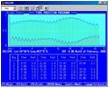
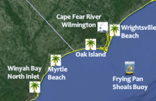
NWS Tide Predictions
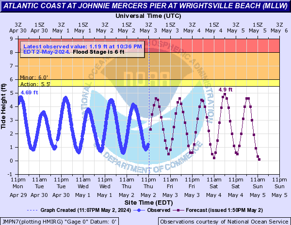
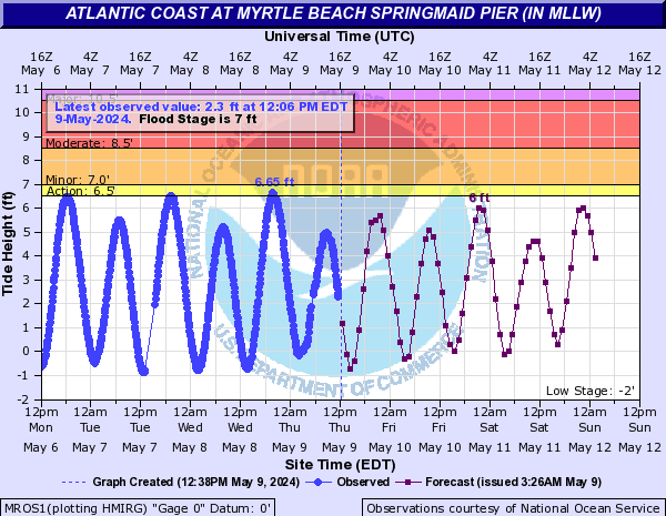
| Wrightsville Beach - Johny Mercer Pier | Cape Fear River-Downtown Wilmington | Myrtle Beach - Springmaid Pier |
 |
 |
 |
NOAA Tides and Currents Webpage
Forecast Products and Models |
|||||
|
Forecasts 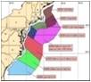
|
|
|
|
|
|
|
|

|
|
|

|
|
Data and Observations |
|||||
|
|
|
|

|

|
|
|

|
 |
|
||
Other References |
|||||
|
|
|
|

|

|
|
|
|
|
||||
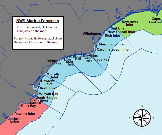
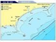
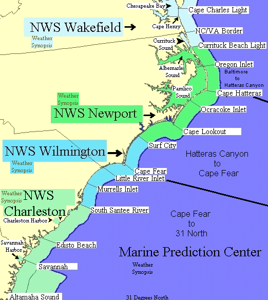
NWS Wilmington, NC is responsible for marine forecasts for the coastal waters from Surf City, NC to South Santee River, SC out to 20 nautical miles.
Forecasts are updated frequently based on the latest observations and forecast guidance.
To report unusual marine conditions, including any waterspouts, to the National Weather Service call toll free 800-697-3901.


 Coastal Flood