 Freezing rain is one of the many types of precipitation that can occur when winter storms strike the Carolinas. Freezing rain develops when falling snow encounters a layer of warm air aloft (often between 3,000 and 7,000 feet above the ground) that melts the snow into rain. As the rain falls further it may encounter a layer of below-freezing air near the surface. This cold air refreezes the precipitation into an icy glaze upon striking elevated objects or sometimes the ground itself. Freezing rain is the most dangerous form of wintry precipitation since only a trace (less than 0.01 inches) can cause road surfaces to become slick and dangerous for travel.
Sleet is produced in a similar manner to freezing rain, but occurs with a deeper (or colder) layer of below-freezing air near the ground. This allows the raindrops to completely refreeze into ice pellets before reaching the surface. Sleet can be mistaken for very small hail since it bounces when hitting the ground but the diameter of a sleet pellet is only a few millimeters, less than 1/10th of an inch. In our climate records sleet is measured like snow and is added in with snowfall accumulations.
Freezing rain occurrence has been part of the weather record for Wilmington since 1947 when regular aviation weather observations began at the New Hanover County airport. The depth of ice accretion has never been recorded in the same way that rainfall or snowfall has been. With the recent introduction of an ice accretion sensor at the Wilmington airport we can now accurately measure the hourly build-up of ice during a storm and compare the rate of icing with temperature and rainfall rate. Applying this relationship to hourly rainfall data in the past it is possible to derive likely amounts of freezing rain from historical storms.
Here is a list of all known ice storms to affect Wilmington since January 1, 1947, the date when routine aviation weather observations began. This list may be updated in the future if new information sources become available.
| # | Start Date | End Date | Ice Accum. | Freezing Rain by Month | ||||
| 1 | 1/24/1948 | 1/24/1948 | 0.06" | Month | # of events | % of total | ||
| 2 | 1/28/1948 | 2/1/1948 | 0.36" | December | 5 | 10% | ||
| 3 | 2/9/1948 | 2/9/1948 | 0.34" | January | 24 | 47% | ||
| 4 | 12/18/1950 | 12/18/1950 | trace | February | 17 | 33% | ||
| 5 | 2/10/1951 | 2/10/1951 | trace | March | 5 | 10% | ||
| 6 | 1/23/1951 | 1/23/1951 | trace | |||||
| 7 | 1/24/1956 | 1/24/1956 | 0.06" | Earliest ice event: | Dec 4, 2002 | |||
| 8 | 1/15/1957 | 1/15/1957 | 0.06" | Latest ice event: | March 12, 1960 | |||
| 9 | 12/11/1958 | 12/11/1958 | 0.09" | |||||
| 10 | 3/9/1960 | 3/12/1960 | 0.11" | # events | Avg Return | |||
| 11 | 1/26/1961 | 1/27/1961 | 0.30" | All events including traces | 51 | 1.5 years | ||
| 12 | 2/3/1961 | 2/3/1961 | 0.06" | Number of events ≥ .01" | 38 | 2.1 years | ||
| 13 | 1/10/1962 | 1/12/1962 | 0.29" | Number of events ≥ .10" | 17 | 4.6 years | ||
| 14 | 3/3/1962 | 3/3/1962 | 0.05" | Number of events ≥ .25" | 8 | 10 years | ||
| 15 | 2/17/1963 | 2/17/1963 | 0.04" | Number of events ≥ .50" | 2 | 39 years | ||
| 16 | 1/10/1968 | 1/11/1968 | 0.06" | Number of events ≥ .75" | 1 | 78 years | ||
| 17 | 1/25/1968 | 1/25/1968 | trace | |||||
| 18 | 2/16/1969 | 2/16/1969 | 0.02" | |||||
| 19 | 1/7/1973 | 1/10/1973 | 0.75" | Number of Freezing Rain Events by Decade | ||||
| 20 | 2/10/1973 | 2/10/1973 | 0.09" | 1940s: | 3 | 1990s: | 1 | |
| 21 | 2/22/1978 | 2/22/1978 | trace | 1950s: | 6 | 2000s: | 5 | |
| 22 | 3/2/1978 | 3/2/1978 | trace | 1960s: | 9 | 2010s: | 7 | |
| 23 | 2/6/1979 | 2/6/1979 | 0.03" | 1970s: | 6 | 2020s: | 4 | |
| 24 | 2/18/1979 | 2/18/1979 | 0.01" | 1980s: | 10 | |||
| 25 | 1/31/1980 | 1/31/1980 | 0.18" | Freezing Rain Amounts by Decade | ||||
| 26 | 3/1/1980 | 3/2/1980 | 0.03" | 1940s: | 0.76" | 1990s: | trace | |
| 27 | 12/27/1980 | 12/27/1980 | trace | 1950s: | 0.21" | 2000s: | 0.28" | |
| 28 | 2/6/1981 | 2/6/1981 | trace | 1960s: | 0.93" | 2010s: | 1.27" | |
| 29 | 1/26/1987 | 1/26/1987 | trace | 1970s: |
0.88" |
2020s: | 0.46" | |
| 30 | 2/16/1987 | 2/16/1987 | 0.14" | 1980s: | 0.64" | |||
| 31 | 1/7/1988 | 1/8/1988 | 0.02" | |||||
| 32 | 1/11/1988 | 1/11/1988 | 0.10" | |||||
| 33 | 3/8/1989 | 3/8/1989 | 0.08" | |||||
| 34 | 12/18/1989 | 12/19/1989 | 0.09" | |||||
| 35 | 2/3/1996 | 2/4/1996 | trace | |||||
| 36 | 1/18/2000 | 1/18/2000 | 0.02" | |||||
| 37 | 1/2/2002 | 1/3/2002 | 0.12" | |||||
| 38 | 12/4/2002 | 12/4/2002 | 0.02" | |||||
| 39 | 2/17/2003 | 2/17/2003 | trace | |||||
| 40 | 1/25/2004 | 1/25/2004 | 0.12" | |||||
| 41 | 1/30/2010 | 1/30/2010 | trace | |||||
| 42 | 1/10/2011 | 1/11/2011 | 0.20" | |||||
| 43 | 1/29/2014 | 1/29/2014 | trace | |||||
| 44 | 2/11/2014 | 2/12/2014 | 0.56" | |||||
| 45 | 2/17/2015 | 2/17/2015 | 0.01" | |||||
| 46 | 2/24/2015 | 2/24/2015 | 0.40" | |||||
| 47 | 1/3/2018 | 1/3/2018 | 0.10" | |||||
| 48 | 1/16/2022 | 1/16/2022 | 0.01" | |||||
| 49 | 1/21/2022 | 1/22/2022 | 0.25" | |||||
| 50 | 2/19/2025 | 2/20/2025 | 0.08" | |||||
| 51 | 1/24/2026 | 1/25/2026 | 0.08" | |||||
Among the freezing rain events in Wilmington's history, two stand out as particularly severe...
January 7-10, 1973
Freezing rain fell on three days (January 7, 8, and 10) with estimated total ice accumulation reaching 0.75 inches. Precipitation was mixed with snow or sleet periodically, and a storm-total measurement of 1.9 inches of snow and sleet was recorded in addition to the freezing rain. Major impacts to road travel and to power lines in New Hanover County were noted, particularly in the then-heavily forested sections of coastal New Hanover County where tree damage was exceptional. The Furniture Fair department store in Jacksonville, NC (Onslow County) collapsed due to the weight of the ice and snow, killing one person and injuring two.
Some articles from the Wilmington Star-News from February 9-11, 1973. (click on each image for a full-screen version)


February 11-12, 2014
The second largest ice storm in Wilmington's history dropped 0.56 inches of freezing rain over two days, with major impacts to trees and power lines. Accumulations of freezing rain were even larger across the Pee Dee region of South Carolina where multiple reports were received of between 1.0 and 1.5 inches of ice. In Wilmington precipitation began as rain and sleet during the day of February 11, but transitioned over to purely freezing rain during the evening. After a lull in precipitation overnight, freezing rain began again during the morning of February 12 and lasted through the morning before temperatures warmed above freezing. Tree damage from this storm appeared similar to that from a strong tropical storm or even category 1 hurricane. New Hanover County took the unusual step after the storm of activating their vegetative debris removal contract for county residents, previously done only after tropical cyclones.
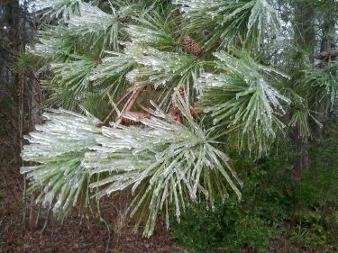
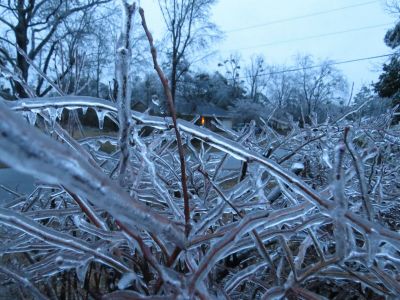
Some local photos from this storm:
.jpg)


Page Author: Tim Armstrong
Page Created: February 23, 2014
Page Last Updated: February 2, 2026


 Coastal Flood