Homestead Hurricane 1945 - Flooding in the Eastern Carolinas
Overview ~ Rainfall ~ River Crests ~ Impacts ~ Newspaper Clippings ~ References
|
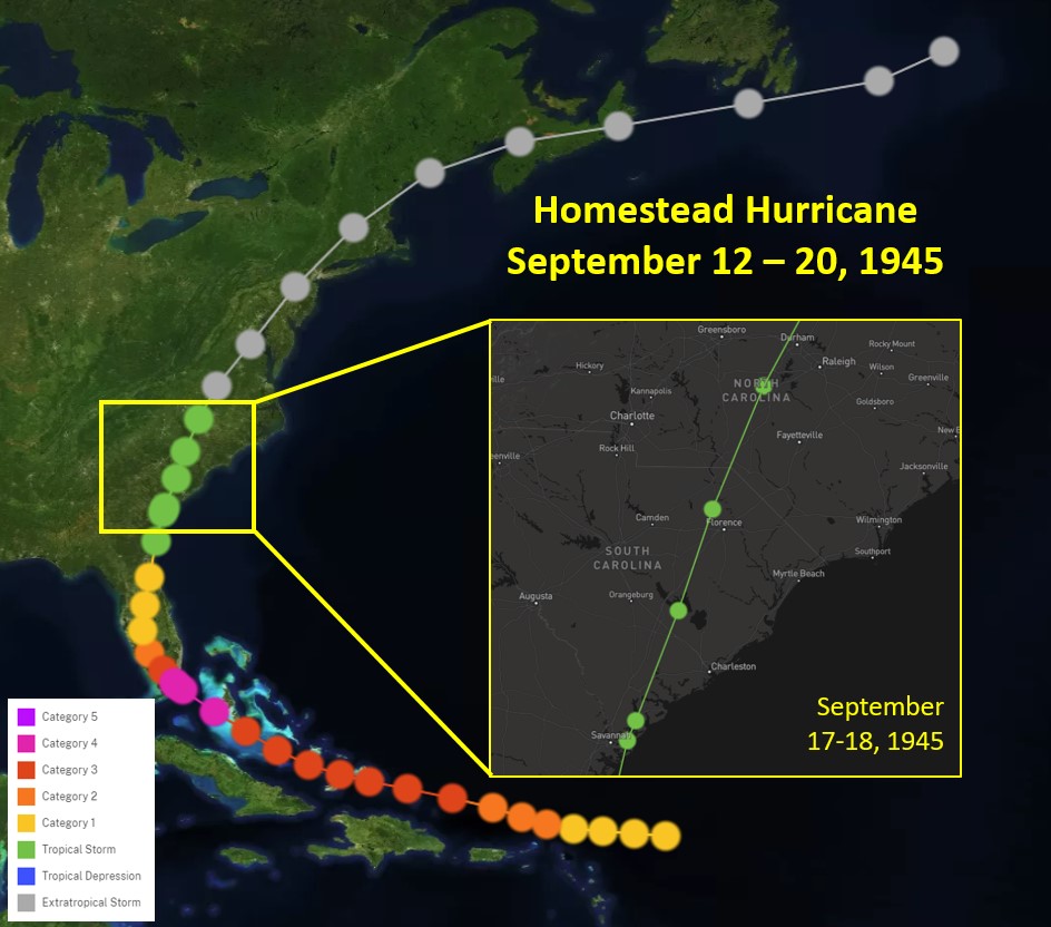
Track of Homestead Hurricane in September 1945 |
During September of 1945, major flooding occurred across the eastern Carolinas in response to heavy rains from the Homestead Hurricane, so called due to its initial point of landfall at Homestead, FL. The storm was first noted east of the Leeward Islands on September 11, 1945, and while moving west-northwestward passed north of Puerto Rico during the morning of the 13th. The storm made landfall as a category 4 hurricane on the south Florida coast over the northern end of Key Largo about 3:30 pm EDT on September 15th. After the center moved offshore near St Augustine late on the 16th, the storm skirted the Georgia coast before the center moved inland again on the South Carolina coast near Parris Island, where winds of 80 to 90 miles per hour were reported. As the storm began to lose force over the Carolinas, excessive rains caused considerable flooding and major damage to cropland. Serious floods occurred along the Pee Dee and Cape Fear Rivers. The storm was traced as far north as Nova Scotia, where it dissipated on the 19th.
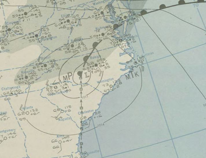 |
| Surface Map from 2:30 AM September 18th, 1945 |
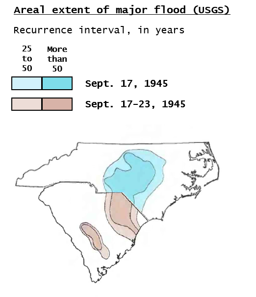
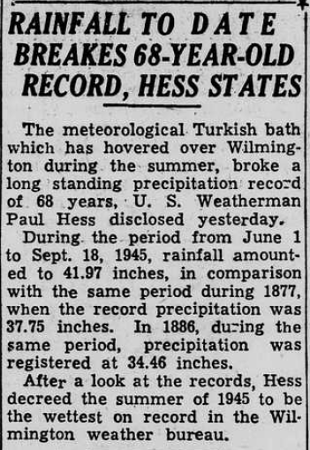
As the Homestead Hurricane moved across the Carolinas as a tropical storm, a corridor of 7 to 10 inches of rain was recorded from the Coastal Plain of South Carolina to the Piedmont region of North Carolina between September 16th and 18th of 1945. One report stated Florence, SC recorded 11.71 inches within 24 hours (Frost, 1956). Antecedent conditions from 2 to 5 inches of rain during the days prior (Sept 13 - 15) across South Carolina and central North Carolina, as well as 2 to 6 inches earlier in the month across the eastern Carolinas, set the stage for major, widespread flooding. The Wilmington Morning Star called it “one of the worst floods eastern North Carolina has ever had.” A COOP observer in Kingstree, SC recorded 17.8 inches of rain from September 1st through 18th, with 17.34 inches measured in Cheraw, SC. Total rainfall for the summer to date at Wilmington (June 1st – September 18th) was measured at 42.05”, which was the highest rain total during that period on record, and was only surpassed by 2018 (Hurricane Florence). Maps from USGS (right) show the areal extent of the major flooding in the Carolinas from mid to late September 1945, with some areas reaching 100-year flood levels.
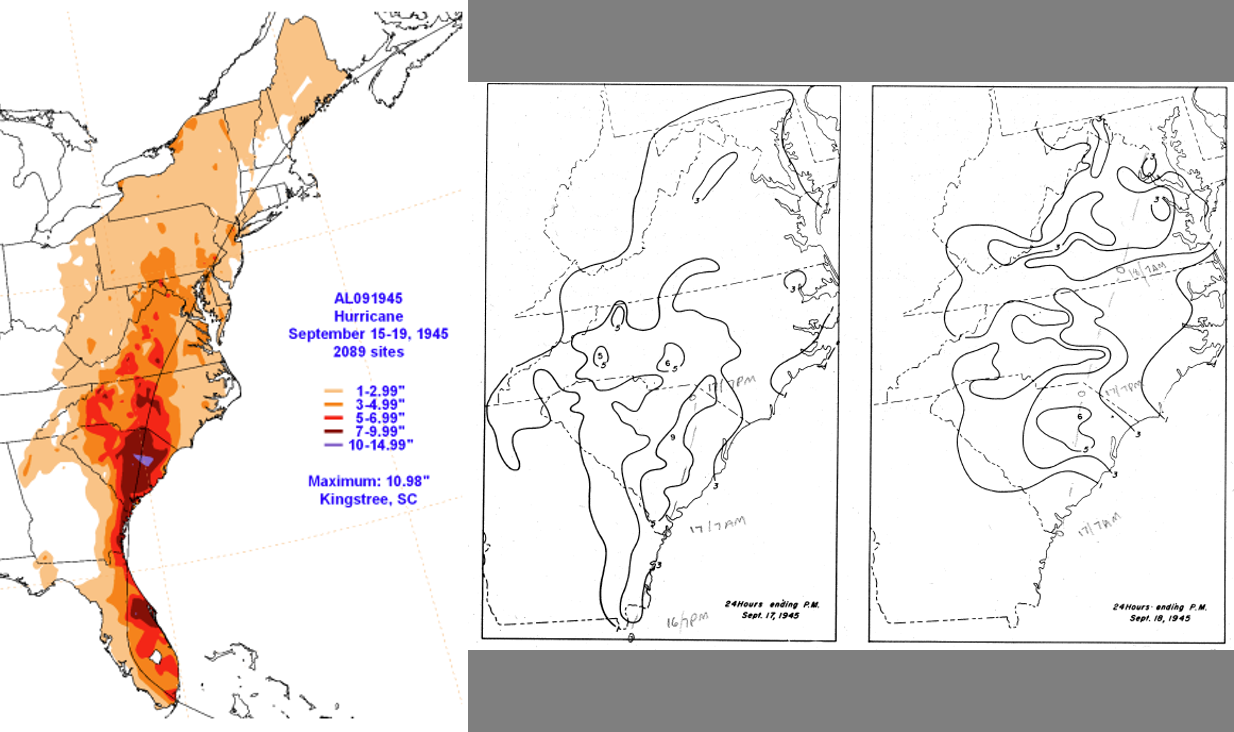 |
| Left: Rainfall totals from September 15 - 19, 1945 from Homestead Hurricane, with maximum of 10.98" in Kingstree, SC. Center: 24 hour rainfall total ending PM on September 17, 1945. Right: 24 hour rainfall total ending PM on September 18, 1945. |
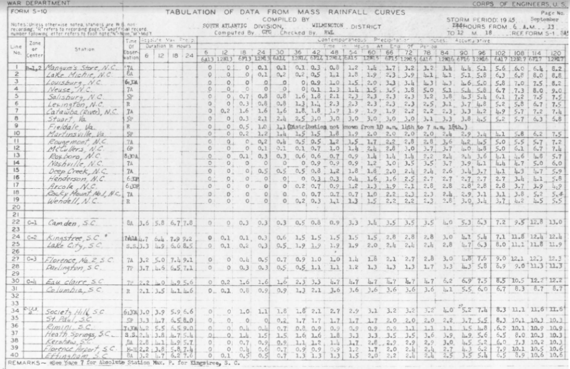 |
| Form S-10: Tabulation of Data from Mass Rainfall Curves. September 13 to 18, 1945. Time increases from left to right, showing accumulation of rainfall totals at various locations in the Carolinas. |
The heavy rainfall from the Homestead Hurricane, combined with antecedent conditions, led to major flooding along many area rivers in the eastern Carolinas, including the Cape Fear and Pee Dee rivers. Although river gauge data is not available from 1945 on the Lumber River at Lumberton, an article from the Robesonian (9/24/1945) stated the river crested just 3 to 4 inches shy of the 1928 flood (which was the worst flood in Lumberton history and the result of back-to-back tropical systems). Across southeast North Carolina and northeast South Carolina, numerous river points reached record levels. Six of these river records still remain (as of 2024), with crests from the Homestead Hurricane higher than those during Floyd, Matthew, and Florence. See the table below for the observed river crests in 1945, where the crest ranks, and how high the river got after Hurricane Florence (2018) as a reference.
| River Name & Location | Homestead Hurricane Crest Level | Ranking (as of 2024) | Hurricane Florence Crest (reference) |
| Cape Fear River at Fayetteville | 68.90 ft | Record | 61.58 ft |
| Cape Fear River at Lock 1 Near Kelly | 29.80 ft | #2 | 30.68 ft |
| Cape Fear River at Elizabethtown | 43.20 ft | Record | 42.51 ft |
| Cape Fear River at William O Huske Lock & Dam | 75.50 ft | Record | 70.75 ft |
| Lynches River at Effingham | 21.21 ft | Record | 16.73 ft |
| Pee Dee River at Cheraw | 50.40 ft | Record | 46.60 ft |
| Pee Dee River at Pee Dee | 33.30 ft | Record | 31.83 ft |
| Little Pee Dee at Galivants Ferry | 13.23 ft | #4 | 17.21 ft |
| Waccamaw River at Conway | 15.60 ft | #7 | 21.16 ft |
| Lumber River at Boardman | 10.64 ft | #7 | 14.36 ft |
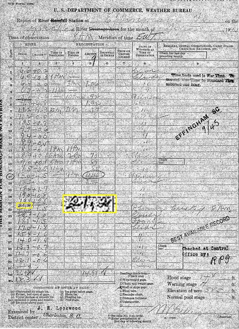 |
| Original report of river levels on the Lynches River at Effingham, SC during the month of September 1945 |
Loss of life from the Homestead Hurricane flooding in the Carolinas was reported as small, with only one fatality noted in South Carolina and three in North Carolina. Millions of dollars (1945) in crop losses occurred across the Carolinas. USGS stated the loss of property and crops in South Carolina was at nearly $7 million (120+ million 2024 dollars). Severe damage resulted to cotton, corn, peanuts, and other unharvested crops in the eastern half of South Carolina. In North Carolina, while the October 12th issue of the Rocky Mount Telegram stated the crop damage across the state was not as severe as first thought, vast areas of crops were flooded with the most serious loss in the hay crop. No dollar amount was found regarding overall crop damage in NC due to the September floods.
The Wilmington Morning Star newspaper fielded over 200 calls in less than five hours from local residents looking for information about weather conditions the night of September 17th. Winds up to 50 miles per hour were reported at Wrightsville Beach, accompanied by enormous waves which pounded piers. Police at Carolina Beach reported that the only damage from the high winds was a downed telephone pole. Heavy rain during the first 3 weeks of September 1945 sent the four major eastern NC rivers (Cape Fear, Neuse, Tar, and Roanoke) out of their banks for an entire week, causing one of the most disastrous flood in the state’s history. Across North Carolina, thousands of acres of crop lands, much of which was planted in cord and hay crops, were inundated and highway and bridge structures were covered for days. One of North Carolina’s worst floods had left thousands homeless and caused uncounted damage to crops and buildings in the states South-Central section.
North Carolina State Highway Department stated the highway system was paralyzed, rendering travel in eastern NC virtually impossible. North Carolina bridges were going out so fast that patrol and the highway department had difficulty in keeping up with developments. NC Highway Commission stated more actual damage was done to top soil and gravel washing on roads and highways than by bridge washouts, with bridge damage localized. Tentative reports from NC State Highway made on September 27th placed damage to secondary roads, highways, and bridges around 1.5 – 2 million dollars (26 - 35 million 2024 dollars).
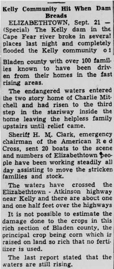
The White Oak Dike along the Cape Fear River failed in several places around September 21st, 1945 and completely flooded the Kelly community of Bladen County with over 100 families evacuated in the fast rising areas. Water was observed up over some houses in the Kelly section, and some people were rescued from second story windows. Water in the area ranged from three to six feet deep and only a few homes appeared to have escaped the floodwaters. Damage from the flood of the Cape Fear and Black rivers in the vicinity of Kelly was estimated at well over a million dollars (17.5 million 2024 dollars), with thousands of head of cattle lost and hundreds of acres of crops ruined. Fayetteville, NC was completely marooned and all highways east and south of Raleigh were inundated. Red Cross officials said 2,269 evacuees in Fayetteville had registered with them. Roughly 20-25% of the city was reported under water. Water reached the eaves of many homes along the flooded rivers, and structural damage in Fayetteville, NC alone was more than $2 million (roughly $35 million in 2024 dollars).
The Lumber River far overflowed its low banks in Lumberton and spread out to inundate several thousand acres of land. In Lumberton, several score residences and other buildings in the area north of Highways 74 and 301 between the 5th St bridge and a spot beyond the old airport were surrounded by water that in some cases ran inside the doors. Several hundred people in out-lying districts of Lumberton had to move from their homes. Surveys done in Lumberton after the flood found losses to furniture and personal effects in many homes were minor. Two dams of a textile mill at Rockingham, NC (Ledbetter Dam and Pee Dee Dam No 1) went out due to the pressure of the high water, and considerable livestock and poultry were lost, with an estimated $500,000 in damage (8.7 million 2024 dollars). Sanford, NC concrete dam broke. An armory, new storage building, and a dairy were flooded along with houses in low areas. As a result of the September 1945 flooding, two major NC lakes and corresponding dams were built to assist with flood control: B. Everett Jordan Lake & Dam (west of Raleigh) and Falls Lake & Dam (north of Raleigh).
Eleven highways in the state of South Carolina were closed as a result of flooding and washouts, including Route 76 between Sumter and Florence. By September 30th, almost two weeks after the storm moved through, six main SC highways were still blocked, including Route 76 along the Pee Dee River between Florence and Marion. Railroads had trouble, with weakened roadbeds reported on both the Southern and Seaboard lines in SC causing delays. South Carolina mail train schedules were subjected to the worst interruption in more than 30 years.
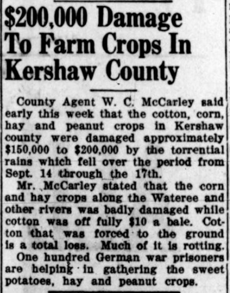
In Camden, SC, hundreds of roofs developed leaks, basements were flooded, stores flooded, and other miscellaneous damage was observed. 400 of the 600 bridges in Colleton County, SC were damaged. Cotton, corn, hay and peanut crops in Kershaw County, SC were damaged approximately $150,000 to $200,000 (2.5 - 3.5 million 2024 dollars) by the torrential rainfall. In Charleston, SC, the bean crop was just about wiped out by high winds and water, with roughly half of the cabbage crop destroyed. Flooding along the Pee Dee River at Cheraw destroyed an estimated several hundred head of cattle and caused heavy property loss. Due to flood conditions in the Wateree and Congaree rivers, spillways at the Santee Cooper hydroelectric project were opened and residents and workers of the Swamplands below the dam were alerted of rising waters. Many families on the Marlboro side of the Pee Dee River had to abandon their homes temporarily and move to higher ground. The Gresham and Britton’s Neck sections of lower Marion County were cut off by flood waters of the Great and Little Pee Dee Rivers. It was estimated that at least 100 families were evacuated.
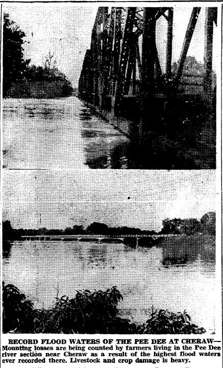 |
| Photos of the Pee Dee River at Cheraw included in the September 28th issue of The State (Columbia, SC) |
 |
 |
 |
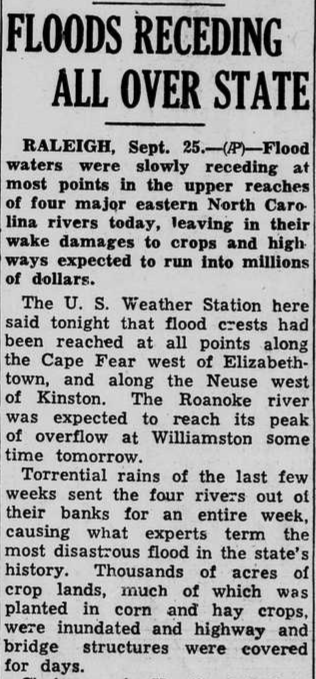 |
| Camden Chronicle - 9/28/1945 | Wilmington Morning Star - 9/19/1945 | Wilmington Morning Star - 9/22/1945 | Wilmington Morning Star - 9/26/1945 |
Research & Page Author: Victoria Oliva
Page Created: June 26, 2024


 Coastal Flood