 |
 |
|
 |
 |
 |
 |
 |
 |
 |
 |
 |
| Winter Weather | Cold | Frost/ Freeze | Heat | Wind | Marine | Tropical | Flood | Severe Weather | Fire Weather |
Click a hazard above to jump to specific criteria
| Hazardous Weather Outlook | Highlights the risk for hazardous weather within the next 7 days. There is a text version and a graphical version. |
 |
 |
 |
 |
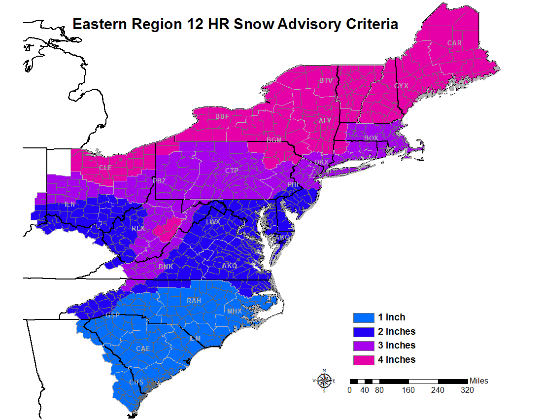 |
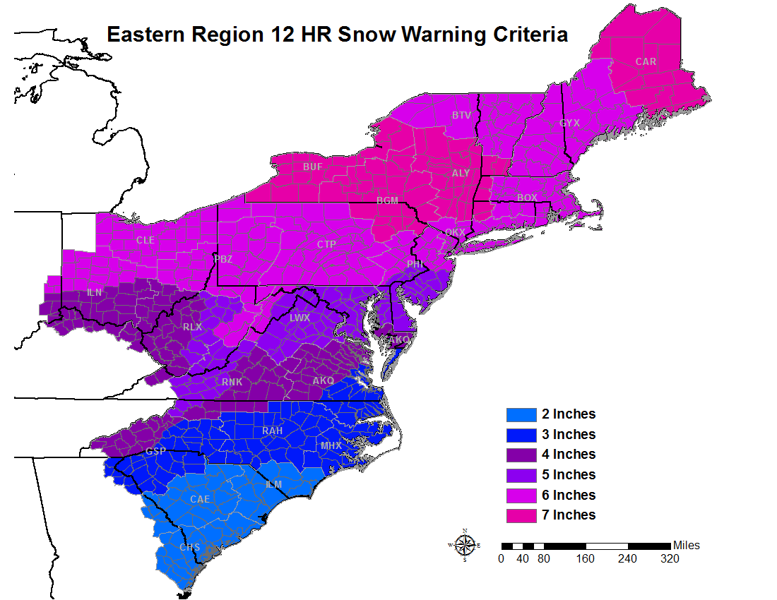
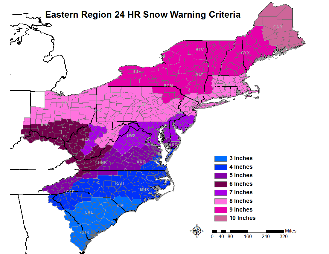
| Ice Storm Warning | Freezing Rain Advisory | 12-hour Snow Warning | 24-hour Snow Warning | 12-hour Snow Advisory |
| Winter Storm Watch | Conditions are favorable for a winter storm event (Snow, Sleet, or Ice (Freezing Rain), or a combination of events) to meet or exceed Winter Storm Warning, Ice Storm Warning or Blizzard Warning Criteria in the next 12 to 48 hours. |
| Winter Storm Warning |
Any of the following: Snow and/or sleet: At least 2" of accumulation within the next 48 hours or less Ice (freezing rain): Accretion of at least 1/4 inch within the next 24 hours or less Combination of winter weather expected to pose a threat to life and property |
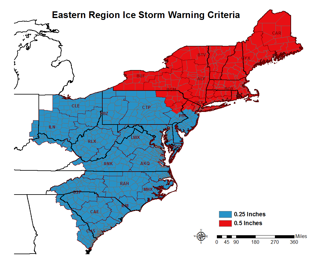
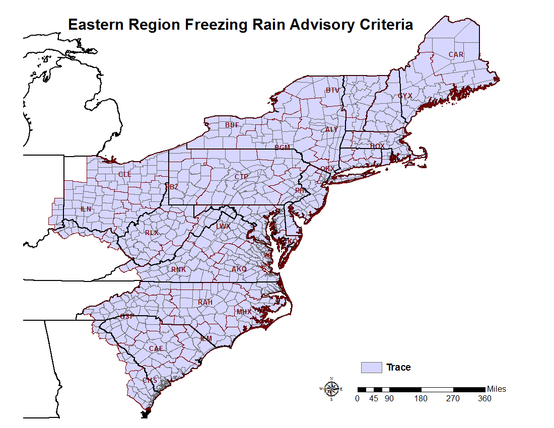
| Ice Storm Warning | Freezing rain is the only or predominate type of wintry precipitation and is expected to accumulate to ¼ inch or greater during a period of 24 hours or less. |
| Winter Weather Advisory |
Any of the following: Snow and/or sleet: 1 to 2" in 12 hours Ice (freezing rain): accretion of a trace up to a 1/4 inch in 24 hours or less Combination of winter weather expected to cause “significant inconvenience” and warrant extra caution |
| Blizzard Warning | Sustained winds or frequent gusts of at least 35 mph accompanied by falling and/or blowing snow frequently reducing visibility to < 1/4 mile for 3 or more hours. |
 |
||
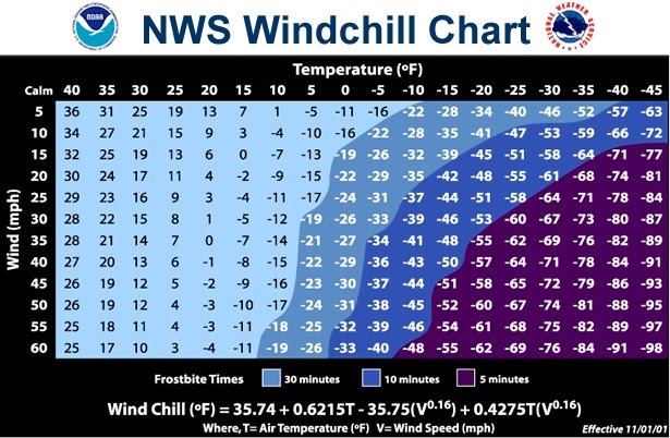
| Extreme Cold Watch | Issued when either temperatures OR wind chills are expected to fall to or below 5 degrees Fahrenheit in the next 24 to 48 hours. |
| Extreme Cold Warning | Issued when either temperatures OR wind chills are expected to fall to or below 5 degrees Fahrenheit within the next 12 to 24 hours. In rare cases, this warning may be issued if the cold weather is expected to pose a significant threat to life due to timing or other circumstances without reaching the criteria stated above. |
| Cold Weather Advisory | Issued when either temperatures OR wind chills are expected to fall to or below 15 degrees Fahrenheit, but remain above 5 degrees Fahrenheit. |
 |
 |
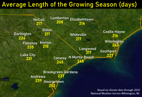 |
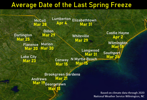
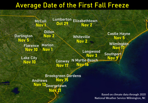
| Freeze Watch | Conditions are favorable for a freeze event to meet or exceed Freeze Warning criteria, during the growing season, which is typically between March 15 and November 15. |
| Freeze Warning | Issued when minimum temperatures are forecast to be 32 degrees or less during the locally-defined growing season (with or without frost). The growing season will officially end in autumn when minimum temperatures drop to 32 degrees or less, across half or more of each individual forecast zone, for three or more hours. |
| Frost Advisory | Issued when minimum temperatures are forecast to be 33 to 36 degrees and conditions are favorable for the development of at least areas of frost during the locally-defined growing season, which is typically between March 15 and November 15. |
| Freezing Fog Advisory | Issued when ground and/or elevated surfaces are below freezing and fog is expected to cause some light ice accumulation. |
 |
 |
| Extreme Heat Watch | Conditions are favorable for an excessive heat event to meet or exceed local Extreme Heat Warning criteria; valid for the entire heat episode and not just the daytime hours. |
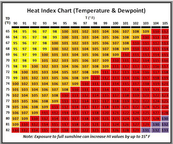
| Extreme Heat Warning | Heat index values 110 F or higher for 2 hours or more. |
| Heat Advisory | Heat index values 105 F to 109 F for 2 hours or more. |
| High Wind Watch | Conditions are favorable for a high wind event to meet or exceed High Wind Warning criteria in the next 12 to 48 hours. |
| High Wind Warning | Sustained winds of 40 mph (35 knots) or higher for 1 hour or more and/or gusts 58 mph (50 knots) or higher for any duration. |
| Wind Advisory | Sustained winds of 31-39 mph (27-34 knots) for 1 hour or more and/or gusts 46-57 mph (40-49 knots) for any duration. |
| Dense Fog Advisory | Widespread fog reducing the visibility to ¼ mile or less. |
| Dense Smoke Advisory | Widespread smoke reducing the visibility to ¼ mile or less. |
| Dust Storm Warning | Widespread blowing dust reducing the visibility to ¼ mile or less. Winds of at least 25 mph are usually required. |
| Blowing Dust Advisory | Widespread blowing dust reducing the visibility to between ¼ mile and 1 mile. Winds of at least 25 mph are usually required. |
| Air Quality Alert | Air Quality Index (AQI) exceeding 100 (code orange air quality alert) as per the South Carolina Department of Health and Environmental Control (DHEC) and per the North Carolina Department of Environmental Quality (DEQ). |
| Hurricane Force Wind Watch | Conditions are favorable for a high wind event to meet or exceed Hurricane Force Wind Warning criteria in the next 12 to 48 hours. |
| Hurricane Force Wind Warning | Non-tropical sustained winds of 64+ knots within 24 hours. |
| Storm Watch | Conditions are favorable for a high wind event to meet or exceed Storm Warning criteria in the next 12 to 48 hours. |
| Storm Warning | Non-tropical sustained winds of 48-63 knots within 24 hours. |
| Gale Watch | Conditions are favorable for a high wind event to meet or exceed Gale Warning criteria in the next 12 to 48 hours. |
| Gale Warning | Sustained winds of 34-47 knots within 24 hours. |
| Dense Fog Advisory | Widespread fog reducing the visibility to 1 NM or less. |
| Dense Smoke Advisory | Widespread smoke reducing the visibility to 1 NM or less. |
| Low Water Advisory | When the water level is forecast to drop, or is observed, below minus 2.0 feet mean lower low water (MLLW). |
| Small Craft Advisory | Sustained winds of 25-33 knots and/or seas 6+ feet. |
| Special Marine Warning | Radar indications and/or reports of any of the following: Winds ≥ 34 knots Hail ≥ ¾ inch diameter (Penny-sized) Waterspouts |
| Coastal Flood Watch | Conditions are favorable for significant coastal flooding (water levels of at least 2.5 feet higher than minor coastal flood thresholds) within 12 to 36 hours. |
| Coastal Flood Warning | Significant coastal flooding (moderate or major coastal flood thresholds are expected to be met) is occurring or imminent within 24 hours. |
| Coastal Flood Advisory | Minor coastal flooding is occurring or imminent within 12 hours. |
| High Surf Advisory | Issued when beach erosion and/or minor ocean overwash are expected due to large breaking waves, 6 feet or greater, in the surf zone. |
| High Rip Risk | Wind and/or wave conditions are expected to support the development of very strong rip currents or when these conditions are reportedly ongoing. |
| Moderate Rip Risk | Wind and/or wave conditions are expected to support the development of stronger rip currents or when these conditions are reportedly ongoing. |
| Tsunami Watch | A tsunami may later impact the watch area. The watch may be upgraded to a warning or advisory or canceled based on updated information and analysis. Emergency management officials and the public should prepare to take action. |
| Tsunami Warning | A tsunami with the potential to generate widespread inundation is imminent, expected, or occurring. Warnings alert the public that dangerous coastal flooding accompanied by powerful currents is possible and may continue for several hours after initial arrival. Warnings alert emergency management officials to take action for the entire tsunami hazard zone. Appropriate actions to be taken by local officials may include the evacuation of low-lying coastal areas and the repositioning of ships to deep waters when there is time to safely do so. Warnings may be updated, adjusted geographically, downgraded, or canceled based on updated information and analysis. |
| Tsunami Advisory | A tsunami with the potential to generate strong currents or waves dangerous to those in or very near the water is imminent, expected, or occurring. The threat may continue for several hours after initial arrival, but significant inundation is not expected for areas under an advisory. Appropriate actions to be taken by local officials may include closing beaches, evacuating harbors and marinas, and the repositioning of ships to deep waters when there is time to safely do so. Advisories may be updated, adjusted geographically, upgraded to a warning, or canceled based on updated information and analysis. |
| Tsunami Information Statement | A tsunami information statement is issued when an earthquake or tsunami of interest to the message recipients has occurred. In most cases, information statements are issued to indicate there is no threat of a destructive basin-wide tsunami and to prevent unnecessary evacuations. Information statements for distant events requiring evaluation may be upgraded to a warning, advisory, or watch based on updated information and analysis. |
| Hurricane Watch | Sustained winds of 64 knots (74 mph) or greater are possible within 48 hours. |
| Hurricane Warning | Sustained winds of 64 knots (74 mph) or greater are expected in a coastal area within 36 hours. |
| Tropical Storm Watch | Sustained winds of 34 – 63 knots (39 – 73 mph) are possible within 48 hours. |
| Tropical Storm Warning | Sustained winds of 34 – 63 knots (39 – 73 mph) are expected in a coastal area within 36 hours. |
| Extreme Wind Warning (EWW) | Sustained winds of 100 knots (115 mph) or greater associated with a major hurricane. |
| Flood Watch | Conditions are favorable for flooding in the next 36 hours. |
| Flash Flood Warning |
Flash flooding is occurring or imminent. Flash flooding is defined by a threat to life or property which would result in the need for immediate action to avoid or mitigate the threat. |
| River Flood Warning | River flooding for specific river points is occurring or imminent. Flood Warnings for rivers are issued for any high flow, overflow, or inundation threatening lives and property which can be quantified or indexed at specific locations and are not covered by flash flood products. |
| Flood Advisory | Issued when elevated stream flow or significant ponding of water occurs or is expected to occur. Flood Advisories may be issued for urban flooding or small stream flooding or a combination of both. This is the most common flood related product ILM issues. |
| Tornado Watch | Conditions are favorable for tornadoes. |
| Tornado Warning | A tornado has been sighted or is indicated by radar. |
| Severe Thunderstorm Watch | Conditions are favorable for severe thunderstorms producing wind gusts of 50+ knots/58+ mph and/or hail of at least 1 inch diameter (Quarter-sized). |
| Severe Thunderstorm Warning |
Observations or radar indications of winds of at least 50 knots (58 mph) and/or hail of at least 1 inch in diameter (Quarter-sized). |
| Special Marine Warning | Radar indications or reports of any of the following: Winds ≥ 34 knots Hail ≥ ¾ inch diameter (Penny-sized) Waterspouts |
| Red Flag Event |
Two or more of the following weather criteria (1 to 4) must be occurring or expected, in addition to high (or more) fire danger (5): 1. Relative humidity of 25% or less. 2. Sustained winds of 20+ mph and/or gusts of 30+ mph. 3. Dry lightning. 4. A significant wind shift during times of active fire suppression. 5. High, Very High, or Extreme fire danger, as assessed by the natural resource agencies. |
|
Red Flag Event is possible (30 to 54 percent probability). |
|
| Red Flag Event is either occurring or imminent. | |
| Fire Danger Statement |
Fire danger or fire occurrence is high with near critical weather criteria. |


 Coastal Flood