Warm weather fans can rejoice: outlooks from the NWS Climate Prediction Center show an increased likelihood of above normal temperatures this summer across North and South Carolina. This is on the heels of a spring that was the warmest in recorded history in Wilmington and the second warmest on record in North Myrtle Beach.
|
CPC's Summer 2024 outlook shows increased potential for above-normal temperatures across the Carolinas |
Temperatures, La Niña, and Climate Change
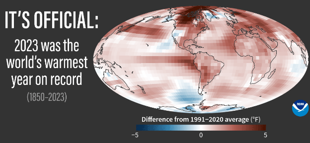
Climate change is tilting the odds in favor of warmer temperatures with each passing year. Climate change over the past century is the result of the accumulation of carbon dioxide, methane, and other gases in the atmosphere from continued extraction and burning of fossil fuels like coal, oil, and natural gas. These gases help trap heat that would normally radiate out into space. NOAA announced 2023 was the warmest year recorded since systematic climate records began in 1850 with global temperatures 2.12° F above the 20th century average.
Wilmington's 2023 observed temperature averaged 1.9° F above 1991-2020 normals while North Myrtle Beach ran 1.0° F above normal.
 |
> > > Read more about Climate Change from NOAA
This summer will have another factor at work that could enhance our potential for above-normal temperatures: La Niña. El Niño and La Niña are two extremes in a natural oscillation in ocean water temperatures across the tropical Pacific Ocean called ENSO - the El Niño Southern Oscillation. A complete cycle from El Niño to La Niña and back again normally takes two to five years to complete.
Last winter, El Niño occurred as water temperatures across the tropical east Pacific ocean were warmer than normal, setting into motion a series of atmospheric changes that normally provide the Carolinas with a wet winter.
|
Live animation of ocean surface temperature anomalies across the Pacific Ocean. The growing body of blue (below normal) water temperatures in the east tropical Pacific may herald the next La Niña |
> > > Learn more about El Niño and La Niña from NOAA
Now in early June, El Niño is quickly fading and there is growing consensus that La Niña may develop later this summer. La Niña occurs when tropical east Pacific Ocean waters become cooler than normal. When a shift to La Niña occurs during our summer months, we usually see a tendency for above normal temperatures to develop across the Carolinas.
Over the past 30 years there have been five times where La Niña developed during the summer: 2020, 2016, 2010, 1998, and 1995. The table below shows temperatures averaged warmer than normal during four of those five summer seasons, and temperatures observed during two of those years (2016 and 2010) were far above normal. This reinforces the Climate Prediction Center's outlook for warm summer temperatures across the Carolinas.
| Wilmington | Lumberton | N. Myrtle Beach | Florence | |
| 1991-2020 AVERAGE SUMMER TEMPERATURE | 79.9° | 80.1° | 79.2° | 80.7° |
| 2020 observed (anomaly) | 80.5° (+0.6°) | 80.0° (-0.1°) | 80.2° (+1.0°) | 81.1° (+0.4°) |
| 2016 observed (anomaly) | 81.4° (+1.5°) | 82.0° (+1.9°) | 81.7° (+2.5°) | 83.1° (+2.4°) |
| 2010 observed (anomaly) | 81.8° (+1.9°) | 82.3° (+2.2°) | 82.2° (+3.0°) | 82.0° (+1.3°) |
| 1998 observed (anomaly) | 80.8° (+0.9°) | 79.3° (-0.8°) | 80.6° (+1.4°) | 82.2° (+1.5°) |
| 1995 observed (anomaly) | 78.8° (-1.1°) | 79.0° (-1.1°) | 78.8° (-0.4°) | 81.1° (+0.4°) |
| Developing Summer La Niña averages (anomaly) | 80.7° (+0.8°) | 80.5° (+0.4°) | 80.7° (+1.5°) | 81.9° (+1.2°) |
Hot summer temperatures can increase heat stress to people, animals, and plants. Warmer temperatures also increase the amount of energy needed for air conditioning, driving up costs to families and businesses. Each one degree F increase in our summer average temperature roughly equals a six percent increase in energy costs.
Rainfall and Drought
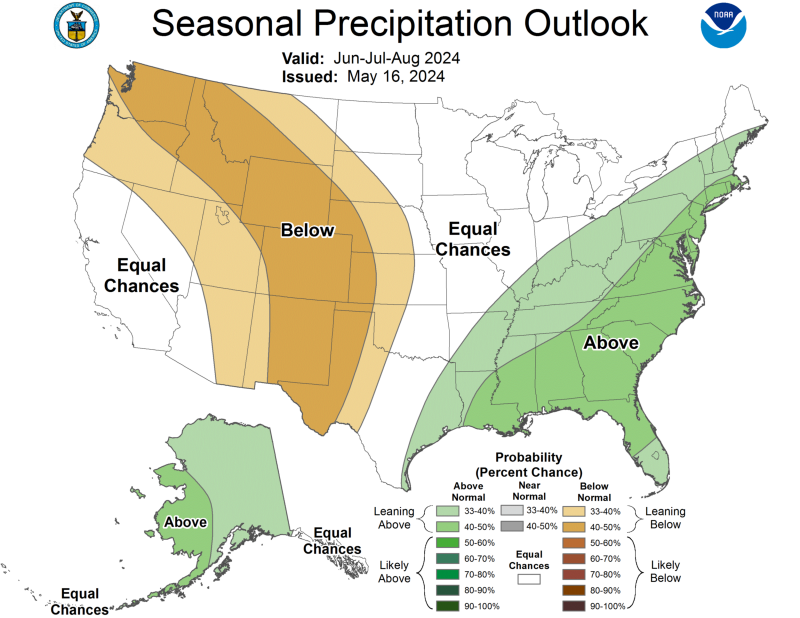
NWS Climate Prediction Center summer outlooks show an increased likelihood of above normal rainfall across the Carolinas. This forecast is based on a combination of above normal sea surface temperatures across the Gulf and Atlantic, plus input from long-range climate forecast models. A warmer ocean evaporates water more quickly into the atmosphere, allowing thunderstorms to drop heavier rainfall.
 NWS Climate Prediction Center outlook for rainfall this summer NWS Climate Prediction Center outlook for rainfall this summer |
Examining local precipitation observed during the past five summers (2020, 2016, 2010, 1998, and 1995) when La Niña formed, there is a wide variety in totals that reflects the random nature of rainfall from heavy summer thunderstorms. An average calculated across all five of those years gives a near normal value, however individual cities observed widely differing totals during each of those years -- some well above normal and others well below.
| Wilmington | Lumberton | N. Myrtle Beach | Florence | |
| 1991-2020 AVERAGE SUMMER RAINFALL | 20.69" | 14.30" | 15.72" | 15.27" |
| 2020 observed (anomaly) | 24.24" (+3.55") | 18.02" (+3.72") | 15.73" (+0.01") | 18.66" (+3.39") |
| 2016 observed (anomaly) | 18.85" (-1.84") | 13.57" (-0.73") | 9.90" (-5.82") | 11.79" (-3.48") |
| 2010 observed (anomaly) | 13.63" (-7.06") | 11.32" (-2.98") | 15.05" (-0.67") | 18.77" (+3.50") |
| 1998 observed (anomaly) | 21.58" (+0.89") | 12.86" (-1.44") | 15.72" (+0.00") | 9.63" (-5.64) |
| 1995 observed (anomaly) | 24.85" (+4.16") | 20.69" (+6.39") | 21.97" (+6.25") | 16.27" (+1.00") |
| Developing Summer La Niña averages (anomaly) | 20.63" (-0.06") | 15.29" (+0.99") | 15.67" (-0.05") | 15.02" (-0.25") |
Fortunately, no drought currently exists across our portion of the Carolinas according to the U.S. Drought Monitor.
Drought outlooks from the Climate Prediction Center also suggest no significant potential for drought to develop this summer.
|
Current U.S. Drought Monitor shows no drought conditions across our portion of the Carolinas |
Summer Drought Outlook from CPC |
Hurricane Season
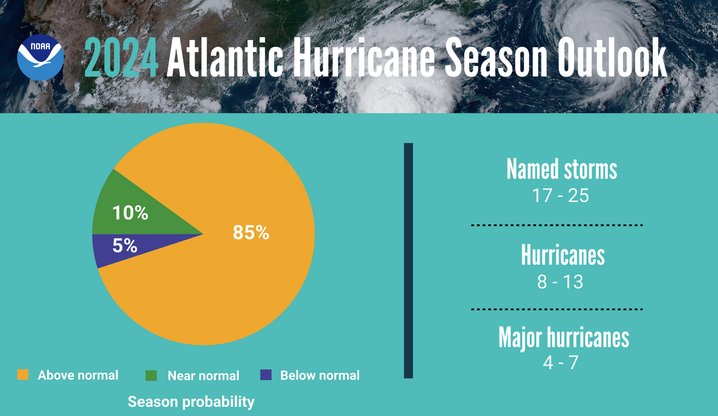
NOAA's official Seasonal Hurricane Outlook calls for an exceptionally active Atlantic Hurricane Season featuring 17 to 25 named storms, 8 to 13 hurricanes, and 4 to 7 major hurricanes. These numbers are well above long-term averages (14 named storms, 7 hurricanes, and 3 major hurricanes) and highlight the importance of remaining aware of the substantial threat this year's hurricane season poses to coastal residents of the United States. Hurricane season officially starts on June 1 and continues through the end of November.
 |
North Atlantic sea surface temperatures are well above normal, alarmingly so across the "Main Development Region" that spans the tropics between the African coast and the Caribbean Sea. This is where many of our late summer and early fall hurricanes have originated -- storms like Bertha, Fran, Floyd, Florence, and Isaias. The additional heat available in the ocean water there could help more storms to develop later this summer, and help those that develop become stronger.
|
Atlantic Ocean sea surface temperature anomalies. Yellow and orange indicate warmer than normal ocean water. The Main Development Region of the Atlantic Ocean has water temperatures anomalies of +1 to 2° C, or +1.8 to 3.6° F. |
Hurricanes (cat 1-5) since 1995 that have directly impacted our portion of the Carolinas. Note how many of these tracks originate within the Atlantic's Main Development Region. |
With a La Niña climate pattern expected to develop by late summer, wind shear across the Atlantic should fall below normal levels. Wind shear weakens hurricanes as it tilts the storm's vertical circulation and spreads its energy over a wider area. Strong wind shear can destroy even a well-developed hurricane. Less wind shear, like we anticipate this year, means hurricanes can more easily form and can reach stronger intensities.
During La Niña there is less thunderstorm activity across the cooler water found in the tropical East Pacific Ocean. This allows an upper level trough to form over the east Pacific, inducing a ridge of high pressure to form downstream across the Caribbean Sea. Low wind shear within this ridge is what can help supercharge the Atlantic Hurricane Season during La Niña years.
|
Typical influence of La Niña on the Atlantic Hurricane Season |
List of tropical storm and hurricane names for the 2024 season |
Over the past 30 years there have been five times where La Niña developed during the summer: 2020, 2016, 2010, 1998, and 1995. These five hurricane seasons produced a number of damaging storms across the Carolinas shown in the table below.
| Year | Storm Name | Local Impacts |
| 1998 | Hurricane Bonnie | Landfall occurred near Surf City, NC on August 26, 1998. Wind gusts reached 74 mph in Wilmington where 9.04 inches of rain fell. Gusts of 89 mph were recorded in Kure Beach. Beach erosion and wind damage to agricultural crops were significant in North Carolina. |
| 2016 | Tropical Storm Hermine | Moved northeastward along the Carolina coast after a Florida Gulf coast landfall. 50+ mph gusts were recorded in the Myrtle Beach area. Heavy rainfall of 8 to 14 inches caused flash flooding. |
| 2016 | Hurricane Matthew | A category five while in the Caribbean Sea, Matthew made landfall as a category one hurricane on the South Carolina coast. Deadly flooding developed across large sections of South and North Carolina due to 12 to 18 inches of rain that fell, exceeding all-time river stages on parts of the Lumber and Waccamaw Rivers. Wind gusts as high as 103 mph were measured at Winyah Bay near Georgetown, SC. |
| 2020 | Hurricane Isaias | Landfall occurred as a category one hurricane at Ocean Isle Beach, NC on August 3. Storm surge flooding was significant along the Grand Strand and Brunswick County beaches, closing roads and damaging homes and businesses from Garden City and Myrtle Beach through Holden Beach, Oak Island, and Southport. The Cape Fear River at downtown Wilmington recorded its highest stage in history due to Isaias' storm surge. |
Another factor to consider for this hurricane season is the strength of the West African monsoon. A monsoon is a component of some climates where seasonal wind shifts cause a significant portion of the year's rainfall to occur in only a few months. A stronger West African monsoon typically means there are more easterly waves that cross the continent and move into the tropical Atlantic Ocean -- some of which become our long-tracked late summer and early fall hurricanes.
According to NOAA's outlook, models are suggesting this year's West African monsoon will be stronger than normal, implying a larger number of tropical disturbances may reach the warm waters of the tropical Atlantic.
> > > Learn more about the West African Monsoon from Meteo-France
If we exhaust the entire Atlantic list of 21 names this hurricane season, there is a supplemental list of names approved by the World Meteorological Organization (WMO) that would be used.
Supplemental Atlantic Storm Names
| Adria | Heath | Orlanda |
| Braylen | Isla | Pax |
| Caridad | Jacobus | Ronin |
| Deshawn | Kenzie | Sophie |
| Emery | Lucio | Tayshaun |
| Foster | Makayla | Viviana |
| Gemma | Nolan | Will |
The complete Atlantic name list is available from the WMO at https://wmo.int/content/tropical-cyclone-naming/caribbean-sea-gulf-of-mexico-and-north-atlantic-names
Coastal Flooding Risk
Astronomical tides will not run excessively high this summer and significant coastal flooding is not likely to occur in the absence of a nearby tropical cyclone or strong onshore winds. Normally large tidal ranges will occur in the days surrounding new moons on June 6, July 5, and August 4, and full moons on June 21, July 21, and August 19. Astronomical high tides will be largest during the August 19 full moon.
|
Astronomical Tide Predictions for Wrightsville Beach, NC, Summer 2024 |
The Monthly High Tide Flooding Outlook from the National Ocean Service has more details about each month's flooding risk.
Wildfire Risk
Forecasters with the National Interagency Fire Center (NIFC) monitor trends in drought, fuel moisture, and plant growth to create maps highlighting the hazards posed by wildfire. Their outlook shows a near normal wildfire risk for this summer season.
|
NIFC Wildland Fire Potential Outlooks for June through August 2024. The wildfire risk is near normal across the Carolinas. |
Avoid outdoor burning on days when low humidity and gusty winds coexist. Check our latest Fire Weather Forecast to see if weather conditions will allow safe burning.
Other Links of Interest
Research and Page Author: Tim Armstrong
Last Updated: June 2, 2024