|
A National Weather Service meteorologist surveyed the damage path near Olanta, SC and determined the tornado was on the ground for 0.6 miles, crossing Woods Bay Rd. |
At 3:00 p.m. on Friday April 19, 2019, a weak tornado touched down in southwestern Florence County, SC near the town of Olanta. This tornado was on the ground for approximately 0.6 miles and had maximum wind speeds around 80 mph, making this an EF0 on the Enhanced Fujita Scale. Damage occurred to two structures and to a number of trees along Woods Bay Road before the tornado lifted in Douglas Swamp. No injuries were reported with this storm.
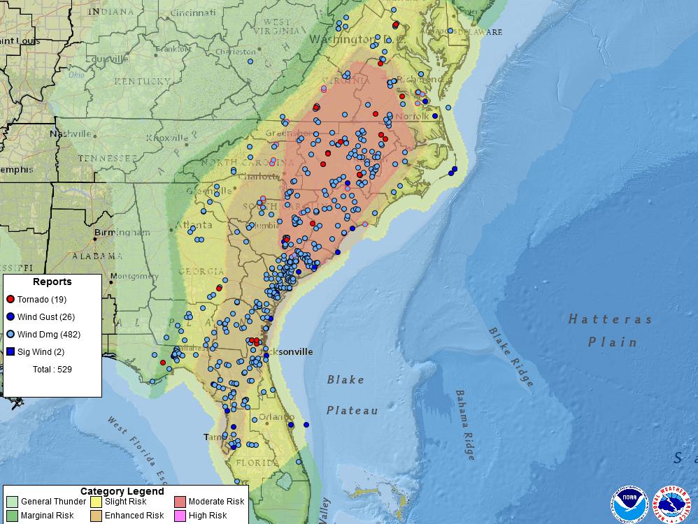
This tornado was part of a significant severe weather outbreak across the Southeast that resulted in hundreds of reports of wind damage. Measured thunderstorm wind gusts reached 64 mph in Fayetteville, NC; 63 mph in Sumter, SC; 61 mph at Hilton Head, SC; and 60 mph in Orangeburg, SC. National Weather Service offices collected a large number of storm reports during the event, all available here: https://www.spc.noaa.gov/climo/reports/190419_rpts.html
Other tornado touchdowns were reported from Florida into Virginia, including one tornado with a seven mile long path near Lincolnton, NC that injured one person.
PUBLIC INFORMATION STATEMENT NATIONAL WEATHER SERVICE WILMINGTON NC 233 PM EDT SAT APR 20 2019 ...NWS DAMAGE SURVEY FOR 04/19/19 OLANTA SC TORNADO EVENT... .OLANTA SC TORNADO EVENT... START LOCATION...NEAR OLANTA IN FLORENCE COUNTY SC END LOCATION...NEAR OLANTA IN FLORENCE COUNTY SC DATE...APR 19 2019 ESTIMATED TIME...3:00 PM TO 3:02 PM EDT MAXIMUM EF-SCALE RATING...EF-0 ESTIMATED MAXIMUM WIND SPEED...80 MPH MAXIMUM PATH WIDTH...30 YARDS PATH LENGTH...0.6 MILES BEGINNING LAT/LON...33.9314/-79.9557 ENDING LAT/LON...33.9386/-79.9517 * FATALITIES...0 * INJURIES...0 ...SUMMARY... THE BRIEF EF-0 TORNADO TOUCHED DOWN SOUTH OF WOODS BAY RD AND WEST OF HIGHWAY 31 NEAR OLANTA, SC. THE TORNADO MOVED TOWARD THE NORTH-NORTHEAST AND PRIOR TO CROSSING WOODS BAY RD CAUSED MINOR DAMAGE TO A HOUSE, LIFTED A LARGE ROOF OFF OF A LARGE OUTBUILDING AND SHED, AND CAUSED SEVERAL TREES TO BE UPROOTED. THE TORNADO CROSSED WOODS BAY RD CAUSING SOME DAMAGE TO TREES AS IT LIFTED IN THE VICINITY OF DOUGLAS SWAMP. EF SCALE: THE ENHANCED FUJITA SCALE CLASSIFIES TORNADOES INTO THE FOLLOWING CATEGORIES: EF0...WEAK......65 TO 85 MPH EF1...WEAK......86 TO 110 MPH EF2...STRONG....111 TO 135 MPH EF3...STRONG....136 TO 165 MPH EF4...VIOLENT...166 TO 200 MPH EF5...VIOLENT...>200 MPH * THE INFORMATION IN THIS STATEMENT IS PRELIMINARY AND SUBJECT TO CHANGE PENDING FINAL REVIEW OF THE EVENT AND PUBLICATION IN NWS STORM DATA. $$ PFAFF |
|
The NWS Storm Prediction Center issues severe weather outlooks in the days leading up to an anticipated severe weather event. Their outlook issued early in the morning of April 19 accurately predicted the areas that would later that day be affected by severe thunderstorms and tornadoes.
From https://twitter.com/NWSSPC/status/1119623533779456002
Page Author: Tim Armstrong
Page Created: April 20, 2019
Last Updated: April 20, 2019


 Coastal Flood