Low pressure developed across northern Georgia on January 2, 2022, then strengthened as it moved northeastward across North Carolina on January 3. A cold front extending south of the low raced across the eastern portions of the Carolinas early in the morning of January 3 bringing a line of severe thunderstorms with wind gusts measured up to 60 mph. Reports of thunderstorm wind damage were received from multiple locations from the Pee Dee region to the coast.
After the thunderstorms moved offshore, wind gusts between 35 and 50 mph continued for much of the day as colder air rushed in.
This same storm system was also responsible for heavy snow across portions of the North Carolina mountains, Virginia, and Maryland where up to a foot of snow fell in spots.
|

Surface weather map for 7 a.m. EST on January 3, 2022
|
| Location |
Peak Gust (mph) |
| Lumberton, NC |
60 mph |
| Florence, SC |
60 mph |
| North Myrtle Beach, SC |
55 mph |
| Wrightsville Beach, NC |
55 mph |
| Murrells Inlet, SC |
53 mph |
| Elizabethtown, NC |
52 mph |
| Marion, SC |
51 mph |
| Oak Island, NC |
50 mph |
| Ocean Isle Beach, NC |
49 mph |
| Pembroke, NC |
49 mph |
| Lockwoods Folly, NC |
48 mph |
| Georgetown, SC |
48 mph |
| Conway, SC |
47 mph |
| Little River, SC |
47 mph |
| Wilmington, NC |
45 mph |
| Kingstree, SC |
45 mph |
| Bald Head Island, NC |
45 mph |
| Southport, NC |
43 mph |
|
|
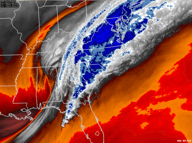
Water vapor satellite imagery shows the storm system that brought strong winds and severe thunderstorms to the eastern portions of the Carolinas on January 3, 2022. Blues and whites show moisture-rich regions, while oranges and reds indicate drier air.
|
|

Early morning radar loop from January 3, 2022 showing the line of severe thunderstorms that crossed eastern portions of North and South Carolina. Reports of wind damage are shown below.
|
| Time (EST) |
County |
Location |
Report |
| 5:45 a.m. |
Florence |
8 miles E of Lake City, SC |
Tree blown down on Huggins Rd. |
| 5:46 a.m. |
Florence |
Florence Regional Airport |
Measured wind gust of 60 mph |
| 5:55 a.m. |
Darlington |
4 miles NE of Darlington, SC |
Tree blown down near the intersection of Lide Springs Rd. and Willowtree Rd. |
| 6:00 a.m. |
Marion |
4 miles S of Marion, SC |
Thunderstorm winds ripped off part of a garage roof and damaged the wall of a home on Hwy 501 south of downtown Marion |
| 6:10 a.m. |
Marion |
Rains, SC |
Tree blown down on a parked car |
| 6:10 a.m. |
Marion |
1 mile NNE of Gresham, SC |
Tree blown down on Thompson Ct. |
| 6:27 a.m. |
Robeson |
6 miles W of Pembroke, NC |
Two homes and an outbuilding were damaged near Craig Rd. and Sampson Rd. |
| 6:36 a.m. |
Robeson |
4 miles SW of Lumberton, NC |
60 mph wind gust measured at the Southeastern Agricultural Center by the LBT airport. |
| 6:41 a.m. |
Horry |
9 miles NE of Conway, SC |
Tree blown down at the intersection of Privetts Rd. and Adrian Hwy. |
| 7:00 a.m. |
Columbus |
Whiteville, NC |
A tree fell and damaged a structure at the intersection of Fuller and Pinckney Streets |
| 7:00 a.m. |
Bladen |
Bladenboro, NC |
Several trees blown down |
| 7:00 a.m. |
Bladen |
4 miles NE of Clarkton, NC |
Power lines and several trees blown down along Lisbon Rd east of Bladenboro |
|
Page Author: Tim Armstrong
Last Updated: January 5, 2022


 Coastal Flood