NWS Wilmington, NC
Weather Forecast Office
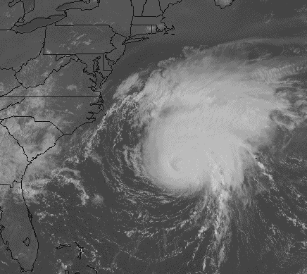
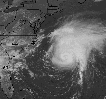
Here are two visible satellite images of Hurricane Edouard as it passed by the coast of North Carolina. Both of these images are from Saturday, August 31st. The first was taken at 915 AM when Edouard was about 375 miles southeast of Cape Hatteras. The second is from 1215 PM when Edouard was about 370 miles southeast of Cape Hatteras. Edouard was a category 3 storm at this time with top wind speeds of 120 mph and was also producing large swells along the coast. Minor beach erosion occurred across the SC and NC coastlines. Click here to read the report on Hurricane Edouard from the National Hurricane Center.
Forecasts
Discussion
Products
Enhanced Graphics
Graph/Table/Text
Graphical
Weather Activity Planner
Aviation
Marine
Hydrology
Rivers/Tides
Tides/Coastal Flooding
Fire
Tropical
Heat
Beach
Surf
Winter
Mobile
Weather Models
Hazards
One-stop Briefing
Graphical Hazard Outlook
Latest Briefing
Social Media Feeds
County EM Briefing
Submit Storm Report
Current Conditions
Observations Map
Observations Listing
Marine Observations
Regional Weather Roundup
Satellite
Past Weather and Climate
Climate Data
Climate Plots
Significant Event Archive
Weather History Calendar
Office Information
About Us
FAQ
Newsletter
Historical Timeline
Office Programs
Education/Outreach
Science and Technology
Skywarn Storm Spotters
CoCoRaHS
Storm/Tsunami Ready
NOAA Weather Radio
US Dept of Commerce
National Oceanic and Atmospheric Administration
National Weather Service
NWS Wilmington, NC
2015 Gardner Drive
Wilmington, NC 28405
(910) 762-4289
Comments? Questions? Please Contact Us.


 Coastal Flood