A Rare Heat Burst affects Georgetown County, SC
On Sunday, July 1, 2012, much of the southeastern United States was in the grip of a record-breaking heat wave. Temperatures had soared well above 100 degrees Friday, Saturday, and Sunday, and heat indices had reached nearly 120 degrees across much of the area. Eventually this heat had to break...and as is typical with significant heat waves, it broke in grand fashion with a severe weather outbreak.
During the evening of Sunday, July 1, 2012, a significant severe weather event occurred across southeast North Carolina and northeast South Carolina. Although widespread wind damage affected much of the area, with more than 60 reports of severe weather received by the National Weather Service (NWS) office in Wilmington, a more interesting, and possibly overlooked phenomenon occurred late that night: A heat burst.
What is a Heat Burst?
Heat Bursts are relatively rare phenomena that occur mainly across the midwest, and are considered quite rare in the southeast. A heat burst is a term used for an event in which temperatures rise dramatically, nearly always occurring very late at night, and are associated with very strong winds and rapidly lowering dewpoints. There are some cases in history of heat bursts causing temperatures to rise to well over 100F in the middle of the night, and others with wind speeds in excess of 80 mph! Fortunately, the heat burst that occurred this night was not this severe.

Meteograms from Georgetown, SC (KGGE) on July 1, 2012. Note the temperature, dewpoint, and wind speeds during the time highlighted in blue.
Between the hours of 8 p.m. and 11 p.m., the temperature at Georgetown rose dramatically. The most rapid warming occurred between 9 p.m. and 1030 p.m. when the temperature rose from 79F to 90F! This occurred at the same time the dewpoint fell from 59F to 45F, and wind speeds gusted to nearly 30 mph. All classic signatures of a heat burst!
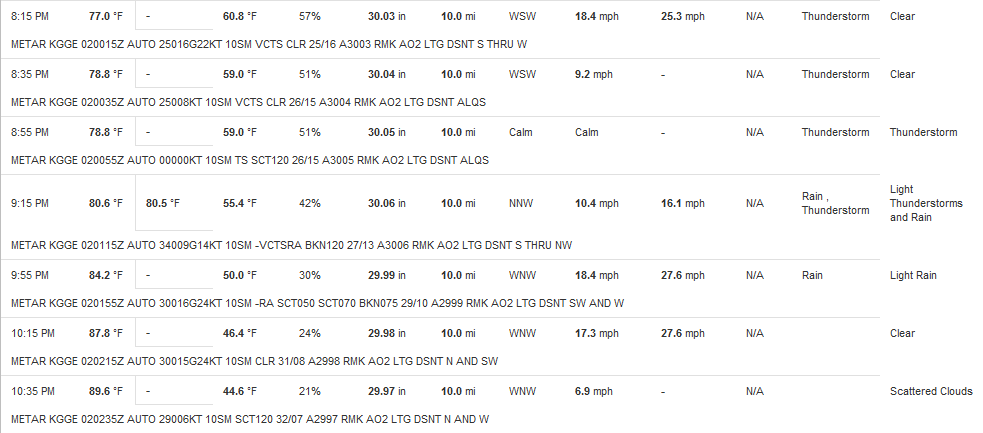
Observations from Georgetown, SC (KGGE) on July 1, 2012. Note how the temperature rose dramatically from 9 p.m. to 1030 p.m., accompanied by rapidly falling dewpoints and increased wind speeds.
From these observations at KGGE, we infer that a heat burst did occur. So what caused this rare event?
What causes a Heat Burst?
A heat burst is caused in the vicinity of a decaying thunderstorm. When a thunderstorm is in its dissipating stage, it becomes downdraft dominated, meaning it has lost all of its updraft-related fuel. When this occurs in an environment characterized by very hot and dry air aloft, and a temperature inversion near the ground, a heat burst can occur. What happens is that the moisture in the downdraft evaporates into the very dry air, which then causes the air parcel temperature to cool. This is known as evaporational cooling. As the air parcels within the downdraft cool, they become more negatively buoyant (move faster towards the ground). Once all the moisture has evaporated out of the downdraft, it's cooling stops, and adiabatic (compressional) warming then begins as the parcel approaches the surface. If the air is moving fast enough, it will penetrate through the surface inversion causing mechanical mixing within the surface layer, and bring the now very warm air all the way to the ground. The higher the thunderstorm base is from the ground, and the drier the mid-level air mass, the more significant the heat burst is likely to be.
Examination of forecast soundings reveals that the environment was ripe for heat bursts during the night of July 1st. Below, the NAM forecast soundings at 2 p.m. for Florence, SC and Wilmington, NC, as well as the observed 8 p.m. sounding from Greensboro, NC are shown.
Note in the NAM forecast soundings the arrow pointing to 850mb temperatures of 25-26C...near record high levels! This shows just how warm the mid-level air mass was this day. Additionally, note the large dewpoint depressions (difference between the temperature line on the right and dewpoint line on the left) above 700mb. Finally, the Lifted Condensation Level (LCL) was nearly 9000 feet AGL this day, meaning thunderstorms bases were extremely elevated, especially for South Carolina in July! This all pointed to the potential for heat bursts if any decaying convection was around during the night.
In the Greensboro, NC sounding an incredible amount of dry air above the surface inversion was present (highlighted in yellow) with dewpoint depressions ranging from 12C to 20C within that layer. Additionally, a very high LCL (the red star) is present around 750mb, and 900-850mb temperatures are well above 23C. The warm and dry air aloft combined with the continued elevated instability all show the potential for a heat burst this night.
 NAM forecast soundings for KFLO (red) and KILM (white) for 2pm on Sunday, July 1, 2012. |
 Observed upper air soundings from KGSO at 8pm Sunday, July 1, 2012. |
Identification on Radar
A few observational studies on identification of Heat Bursts on radar have been completed, with a very good one from the NWS in Albuquerque, NM (ABQ) available here: Heat Bursts near Albuquerque. The NWS ABQ study found a "serpentine-like" structure with weak reflectivities and decent surface wind divergence associated with heat bursts. Identifying this signature can help forecasters determine the potential for ongoing heat bursts when the other parameters described previously come together. Were any of these features evident near Georgetown on the 1st?
In the images below are the 0.5 degree reflectivity and base velocity for KLTX radar in Shallote, NC just after 8 p.m. Note the circled areas on both images. We do see the serpentine like structure noted from NWS ABQ, and this was associated with convection that was rapidly dissipating. Additionally, although it is quite weak, we see weak divergence as well. Is this the heat burst signature? It is impossible to say for sure, especially since there are very few if any observations sites across northeast Georgetown county. However, it appears at least plausible that this is in fact the heat burst as it was happening.
 KLTX base reflectivity at 8pm. The circled region is the likely location of the heat burst. |
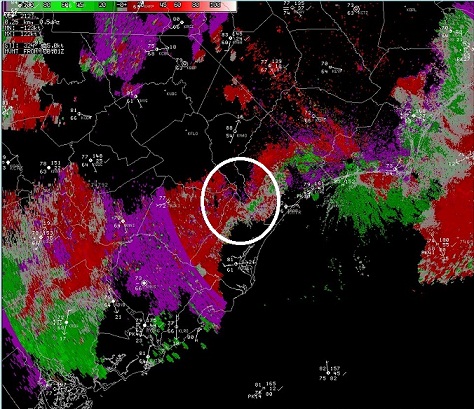 KLTX base velocity at 8pm. The circled region shows weak surface divergence associated with the heat burst. |
As this drifted southward towards Georgetown, it clearly weakened as noted in the image below from just before 9 p.m. Many heat bursts in literature occur very rapidly with incredible temperature rises and wind gusts. However, in this case, winds peaked below 30 mph and the temperature rose only (although still impressively) 11 degrees in 90 minutes. It appears that the heat burst did not occur directly over Georgetown, and instead advected southward into the area causing the more gradual temperature rise and weaker wind gusts. A further example of this advection idea occurred at a mesonet site located north of Georgetown. This site, which was closer to the theorized heat burst origin in the images above, experienced a dramatic temperature rise from 77F to 90F in only 46 minutes! Since Georgetown was further south, it makes sense that the temperature rise here was less extreme.

KLTX base reflectivity just before 9pm showing the weakening reflectivity structure of the heat burst.
While most of us were focused on the extreme heat and significant severe weather outbreak that occurred this day, a rare heat burst caught a few by surprise across Georgetown County. Heat Bursts are quite rare in the southeast, and this was a neat event that will likely not occur again for a long time in this area.
Page Author: Joshua Weiss


 Coastal Flood