 A very damaging winter storm affected eastern North and South Carolina February 11-12, 2014. This event produced devastating amounts of freezing rain along and east of Interstate 95 all the way down to the coast, with ice accumulations measured as high as 1.5 inches in Kingstree, SC. Tree damage across northeastern South Carolina was comparable to that caused by Hurricane Hugo in September 1989. Monetary damage to forests alone was estimated at $360 million. Interior eastern South Carolina and southeastern North Carolina also received large accumulations of snow and sleet -- measured as high as 8 inches in Bennettsville, SC.
In Wilmington this was the second largest ice storm on record since 1947 with over half an inch of ice measured at the Wilmington International Airport. An ice storm of this magnitude is estimated to occur only once every 30-35 years (on average) in this part of the country.
This was actually the second significant winter storm to affect the eastern Carolinas within a few weeks; an earlier winter storm on January 28-29, 2014 dumped 2 to 4 inches of sleet and snow across southeastern North Carolina and the Pee Dee region of South Carolina, with lesser amounts reported along the Grand Strand.
|
Freezing Rain reports Brunswick County NC... .New Hanover County NC... .Pender County NC... .Robeson County NC... .Florence County SC... .Horry County SC... .Marion County SC... |
Freezing Rain Totals for the February 11-12, 2014 Winter Storm |
|
Snow & Sleet reports .Bladen County NC... Dublin, 2 miles ESE 5.8" .Columbus County NC... .Pender County NC... Atkinson Trace .Robeson County NC... .Darlington County SC... .Dillon County SC... .Marlboro County SC... |
Snow and Sleet combined totals from the February 11-12, 2014 Winter Storm |
Meteorological History
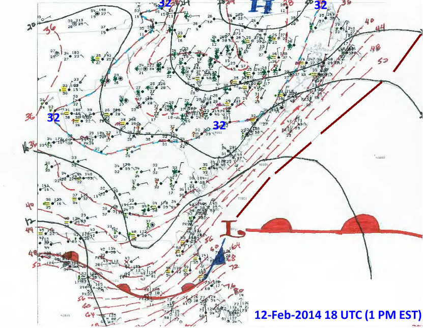 Cold and dry air settled into the Carolinas on February 10, 2014, pushed southward by arctic high pressure over New England. The cold front at the leading edge of this airmass stalled along the Gulf Coast states and northern Florida that evening. Two areas of low pressure developed along the stalled front and moved northeastward into the Atlantic. The first low developed during the morning of February 11th along the front east of the Georgia coast. A broad zone of overrunning precipitation developed in association with this low. Precipitatoin was mainly snow across northern South Carolina and interior North Carolina where cold air was deepest; rain or freezing rain was reported along the coast where slightly warmer air existed above the surface. This first low dissipated off the Georgia coast during the evening of February 11th as dry air arrived in the mid-levels of the atmosphere, ending most of the substantial precipitation and leaving only light pockets of freezing rain overnight.
A second wave of substantial precipitation developed during the morning of February 12th in advance of a deepening upper level trough over the lower Mississippi Valley. As south winds strengthened through the mid-levels of the atmosphere. enough warmth was brought northward to change this second wave of precipitation over to mainly freezing rain across the coastal plain of the Carolinas. This limited snow to just interior North Carolina and northern South Carolina including the Lumberton and Bennettsville areas, plus points farther north and west. The most substantial freezing rain accumulations near the coast occurred during the morning hours of February 12th with precipitation rates over 0.10" per hour. Surface temperatures along the coast began to rise above freezing by noon on the 12th, with the freezing line slowly progressing inland during the afternoon and early evening hours. The freezing line never reached the Interstate 95 corridor until after the end of the precipitation.
The National Weather Service in Wilmington issued a Winter Storm Watch at 4 a.m. on February 10th. This was upgraded to a Winter Storm Warning at 3 p.m. on February 10th for most of the area. (The warning for parts of the coast was issued late in the morning of February 11th) Winter Storm Warnings remained in effect until the conclusion of the hazardous weather during the morning of February 13th.
Local Impacts
Although substantial amounts of snow and sleet fell across interior portions of eastern North and South Carolina, damage from this storm was primarily attributed to a heavy accumulation of freezing rain that fell across the Pee Dee region of South Carolina into coastal North Carolina. A swath of ice accretion in excess of one inch occurred from northern Horry County through Marion County, southern Florence County, and into western Williamsburg County. Widespread damage occurred to trees and power lines, with electric service not fully restored in some areas for a week. South Carolina forestry officials compared the damage across parts of South Carolina to that of Hurricane Hugo back in September 1989. South Carolina Emergency Management declared a state of emergency during the storm; they and the American Red Cross opened emergency shelters. At one point nearly 350,000 South Carolina residents were without power. The severity of the damage led to 21 counties in South Carolina being declared a federal "major disaster area" including Dillon, Florence, Georgetown, Horry, Marion, and Williamsburg counties.
In North Carolina alone there were 1,800 traffic accidents reported to the NC Highway Patrol, with upwards of 100,000 residents without power during the worst of the storm.
A few local pictures from the event:
|
Ice bringing trees down on Kings Grant Road in Wilmington, NC. |
Ice covering a early spring hyacinth. Wilmington, NC |
|
A tree heavily damaged due to large accumulations of freezing rain. Wilmington, NC |
A heavy accumulation of freezing rain on a satellite dish at the National Weather Service office in Wilmington, NC. Over half an inch of ice was measured here. |
|
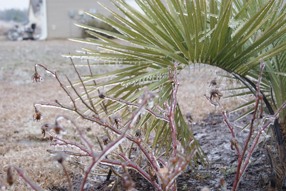
Ice covering a small palm tree. Photo by Heather Solomon of Longs, SC |
A flip-flop, usually a sign of summer, is covered with a layer of ice. Photo by Heather Solomon of Longs, SC |
|
A very icy scene in Burgaw, NC. Photo by Rick Beacham. |
Icicles hanging underneath an outdoor table in Burgaw, NC. Photo by Rick Beacham. |
|
Icy trees in Burgaw, NC. Photo by Rick Beacham. |
Icy bushes in Burgaw, NC. Photo by Rick Beacham. |
Other Links
"One For The History Books" by NWS Peachtree City, GA. Lots of good maps and radar loops here.
February 2014 Significant Snow and Ice Storm by NWS Columbia, SC
Horry County Ice Storm, February 11-13, 2014 by My Horry News
Winter Storm Troubles Persist in Myrtle Beach Area by Myrtle Beach Online
Winter Storm Database for Feb 11, 2014 from the NC Climate Office
Winter Storm Database for Feb 12, 2014 from the NC Climate Office
Wilmington, NC Ice Storms Since 1947 A list of every occurrence of freezing rain in Wilmington since 1947.
Page Author: Tim Armstrong
Page Created: February 10, 2015
Last Updated: February 11, 2015


 Coastal Flood