 Hurricane Bertha made landfall in southeastern North Carolina as a category 2 hurricane on July 12, 1996. Bertha's wind speeds were measured as high as 116 mph at the Frying Pan Shoals tower off Cape Fear. On land, gusts exceeded 90 mph at Kure Beach, Wrightsville Beach, and Figure Eight Island, and reached 108 mph at the New River Marine Corps Air Station near Jacksonville, NC. Bertha was the first significant storm to affect the area since 1984's Hurricane Diana struck almost twelve years earlier. Bertha's arrival unfortunately began a four year period of frequent, damaging hurricanes for eastern North Carolina that would ultimately include Hurricanes Fran, Bonnie, and Floyd.
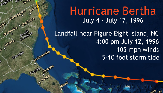
Bertha began as a tropical wave that moved off the west coast of Africa into the Atlantic Ocean on July 1, 1996. During the evening of July 4th the National Hurricane Center began issuing advisories on a newly-formed tropical depression midway between the African coast and the Lesser Antilles islands, upgrading it to Tropical Storm Bertha the next day. Bertha acquired hurricane force winds on July 7th, and on July 9th strengthened into a major hurricane (category three) with winds of 115 mph while located a short distance north of Puerto Rico. This was very early in the hurricane season for such an intense storm to develop; the last time a category three storm occurred so early in an Atlantic hurricane season was in 1966 when Hurricane Alma reached category three intensity on June 8.
After passing Puerto Rico on July 9th, Bertha turned northwestward and slowed its forward speed as it entered the Bahamas. Moving northward on July 11th a few hundred miles east of the Florida coast, Bertha weakened rather substantially as northwesterly wind shear developed over the storm. Maximum sustained winds decreased to 80 mph versus 115 mph only two days earlier. Visible satellite imagery from July 11th showed deep thunderstorms confined to the east side of Bertha's circulation, with an exposed low-level swirl of clouds around the actual center. Thunderstorms wrapped back around the center during the morning of July 12th as the storm approached the North Carolina coast. Maximum sustained winds strengthened to 105 mph before landfall, which occurred at 4:00 pm over Figure Eight Island, NC.
|
Hurricane Bertha GOES-8 infrared satellite loop. July 10-12, 1996 |
Hurricane Bertha GOES-8 visible satellite loop. July 10-12, 1996 |
A Hurricane Watch was issued for the entire coast of North and South Carolina at 11 pm on July 10th. This watch was upgraded to a Hurricane Warning at 5 pm on July 11th. A FEMA report estimated 750,000 people evacuated the Carolinas ahead of Bertha. Residents of the North Carolina coast awoke on July 12th to rain and wind gusts of 20-30 mph; these winds increased to 40-60 mph by late morning and beyond hurricane force near the beaches during the afternoon. Bertha's strongest winds and landfall occurred near the time of low tide which helped prevent more significant coastal flooding and erosion than was observed. The largest storm surge of 8 to 10 feet was observed in Swansboro and Emerald Isle along the Onslow County, NC coast just east of where the eye came ashore.
|
North Topsail Beach: Ocean City Fishing Pier damaged, 200 feet destroyed. Approximately 25% of homes lost roofs. Several thousand feet of New River Inlet Road washed away. Complete power loss across island. Surf City: Barnacle Bill's pier damaged. Forty homes destroyed. Dunes destroyed, and four feet of sand deposited on highway 210. Topsail Beach: 50 homes damaged, five severely. Wrightsville Beach: Town water and sewer service out. Johnnie Mercer Pier damaged with 75 feet missing. Oceanic Pier damaged. Widespread roof damage to homes. Coast Guard closed the Intracoastal Waterway between Wrightsville Beach and Carolina Beach due to the number of sunken boats and submerged debris. Carolina Beach: Carolina Beach pier destroyed; Center Fishing Pier damaged. Northern portion of Pleasure Island overwashed. Twelve homes damaged. Power out, sewage system failed. Two feet of ocean water on main highway, with up to three feet of sand deposited across four blocks of North Carolina Avenue. Dunes destroyed. Kure Beach: Damage to many homes. Kure Beach pier destroyed. Wilmington: State of Emergency declared. 8 pm to 5 am curfew enforced. Damage to over 100 homes. Navy ship moored downtown broke free during the storm and damaged the waterfront docks. Around $1 million in damage to hospital. Southport: City Hall roof destroyed. Historic Wittler's Bench cedar tree destroyed. Long Beach: Two homes lost their roofs. Holden Beach: One home already threatened by erosion was destroyed; four others damaged. Ocean Isle Beach: Seven homes damaged. Frying Pan Shoals tower: Waves measured at 28 feet high. |
||||||||||||||||||||||||||||||||||||||||||||||||||||||||||||||||||||||||||||||||||||||||||||||||||||||||||||||||||||||||||||||||
Hurricane Bertha was responsible for 12 deaths and caused at least $270 million in damage within the mainland United States. Bertha also spawned seven confirmed tornadoes, including one in North Carolina, one in Virginia, and five in Maryland.
In addition to impacts on people, hurricanes often blow oceanic birds far off course and inland. A Wilson's Storm-Petrel was observed on Lake Pinehurst in Moore County, NC on July 13, 1996. At Cape May, NJ, eight Black-capped Petrels were observed. Virtually every inland record of these species is associated with landfalling hurricanes.
Despite the impact Hurricane Bertha had in the Caribbean and United States, it didn't meet the notoriety thresholds needed to retire the name. In 2002 Tropical Storm Bertha affected Louisiana and Texas; in 2008 Hurricane Bertha affected Bermuda; and in 2014 Hurricane Bertha affected parts of the Caribbean islands.

Hurricane Bertha radar loop showing landfall of the storm along the coast of New Hanover and Pender counties in North Carolina. Loop runs from 4:03 AM to 6:41 PM on July 12, 1996.
|
Surface weather maps showing the landfall of Hurricane Bertha on July 12, 1996. These maps were hand-analyzed in July 2016 using historic weather observations collected during the event. |
|
|
H*Wind analyses of wind fields around Hurricane Bertha: July 8-12, 1996 Source: NOAA/AOML/HRD |
|
Newspaper articles on Hurricane Bertha from the Wilmington Morning Star newspaper -- now called the Wilmington Star-News
|
July 13: Bertha Batters Cape Fear |
July 13: Curfews imposed for area beaches |
July 13: It's in God's hands now |
July 14: Carteret County Whipped Hard |
|
July 14: map of observed storm damage |
July 14: Strongest winds rip Onslow, Topsail Island |
July 15: In Bertha's Wake |
July 17: Kure Beach condos teetering |
| Excellent video from Surf City, NC showing a fishing pier collapse, and an amazing view up into Hurricane Bertha''s eye! | Various scenes around Wrightsville Beach and Wilmington during Hurricane Bertha |
| Scenes inside the National Hurricane Center and some Hurricane Bertha damage video | Weather Channel tropical update during Hurricane Bertha; scenes from Wrightsville Beach and Hatteras Island. |
Additional Information on Hurricane Bertha
Official National Hurricane Report: http://www.nhc.noaa.gov/data/tcr/AL021996_Bertha.pdf
Hurricane Bertha NWS Service Assessment: https://www.weather.gov/media/publications/assessments/bertha.pdf
Bertha overview from NWS Newport/Morehead City: https://www.weather.gov/mhx/Jul121996EventReview
County-specific impacts from NCDC's Storm Data Publication: Charleston, Georgetown, Horry, Brunswick, New Hanover, Pender, Onslow, Carteret, Pamlico
Research and Page Author: Tim Armstrong
Date Created: July 7, 2016
Last Updated: July 18, 2021


 H*Wind analyses")


 Coastal Flood