Severe thunderstorms developed across North and South Carolina during the afternoon and evening of April 20, 2024. Large hail and damaging winds occurred in multiple swaths from Maxton and Pembroke into the city of Lumberton, and from Hartsville and Society Hill to Nichols and Loris. This was the most significant outbreak of large hail across this portion of the Carolinas since May 7, 2021.
|
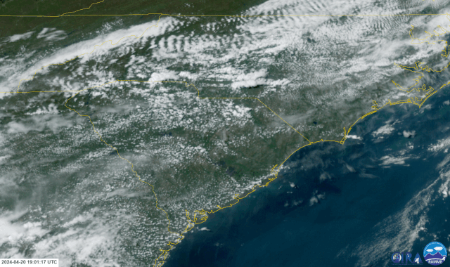
Geocolor weather satellite loop from 3:00 pm until 9:30 pm on April 20, 2024. Clusters of severe thunderstorms can be seen developing and moving east-southeastward across the Carolinas. Imagery processed by CIRA at Colorado State. |
An nearly stationary front extended across eastern North Carolina into western South Carolina during the early afternoon hours. South of the front temperatures soared into the mid 80s, helping generate convective instability as large as 3000 J/kg according to real-time model analysis. In general, values over 2500 J/kg indicates strong instability -- meaning with the proper trigger and wind shear the atmosphere could be capable of supporting strong to severe thunderstorms.
|
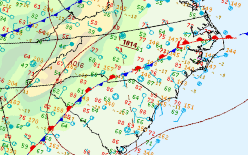
WPC surface analysis maps at 2 pm, 5 pm, 8 pm, and 11 pm on Saturday, April 20, 2024 |
Thunderstorms began developing along the front in the Charlotte area between 2 and 3 pm. These storms became severe before 4 pm, producing large hail and damaging winds in Gaston County, NC; and in York and Cherokee counties in SC. Storms moved east-southeastward across the Sandhills and into the Laurinburg-Maxton area around 4:30 pm. The storms struck Pembroke shortly before 5:00 pm dropping quarter to golf ball-size hail. The storms slid southeastward across Lumberton and into western Bladen county where multiple reports of hail golf ball size or larger were received.
As the front began to sink southward, a second cluster of severe thunderstorms developed south of Charlotte and moved into South Carolina's Pee Dee region around 6:00 pm. Quarter-sized hail fell in Hartsville and Brownsville, SC. In addition, damaging wind gusts blew down trees and power lines in Society Hill, SC. This cluster of storms continued moving east-southeastward into Horry County where quarter to ping pong ball size hail was reported from two locations in Loris shortly after 8:00 pm.
|
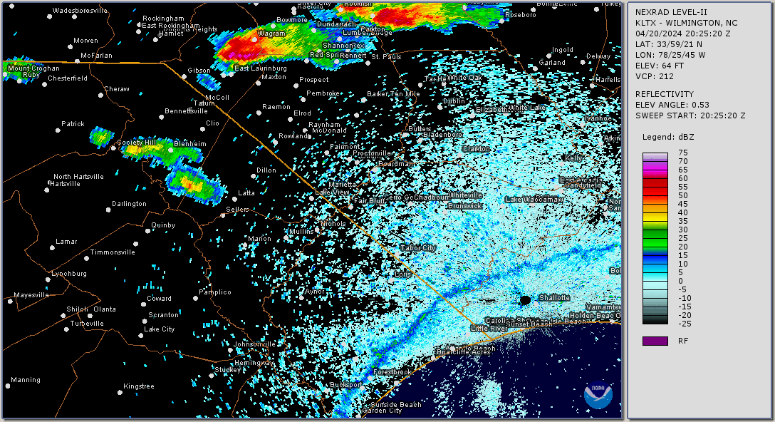
Radar loop from 3:00 pm until 9:30 pm on Saturday, April 20, 2024. |
Another cluster of severe thunderstorms developed near in Duplin County near the county line with Pender around midnight. Damage appears it was limited to Duplin County. A final round of thunderstorms also affected the Grand Strand area around midnight. As these storms exited the coast a wind gust of 49 mph was recorded at Springmaid Pier in Myrtle Beach.
Reports received from locations in and near the NWS Wilmington forecast area:
| Time | Location | County | State | Report |
| 4:17 PM | 6 NNE Laurel Hill | Scotland | NC | Quarter sized hail covered the ground on Camp Monroe Rd. |
| 4:21 PM | 4 NE Laurel Hill | Scotland | NC | Downed trees were reported to down power lines along McFarland Rd, Old Wire Rd, and Traders Rd |
| 4:31 PM | 5 S Wagram | Scotland | NC | Ping pong ball sized hail |
| 4:39 PM | 2 NNE Maxton | Robeson | NC | Ping pong ball sized hail reported at County Line Store |
| 4:39 PM | 6 E East Laurinburg | Scotland | NC | Ping pong ball sized hail reported at County Line Store on NC-71 |
| 4:50 PM | 4 NNE Pembroke | Robeson | NC | Hail fell for about 10 minutes. Size ranged from marbles to quarters. |
| 4:54 PM | 4 N Lancaster | Lancaster | SC | Quarter sized hail |
| 4:57 PM | 2 NNW Pembroke | Robeson | NC | Golf ball sized hail |
| 4:57 PM | 3 NE Lancaster | Lancaster | SC | 2 inch diameter hail. Hail lasted about 10 minutes |
| 4:58 PM | 3 NE Pembroke | Robeson | NC | Golf ball sized hail reported near the intersection of Highway 72 and Union Chapel Road |
| 5:02 PM | 1 ENE Pembroke | Robeson | NC | Quarter sized hail fell for about 5 minutes |
| 5:10 PM | 3 NE Elgin | Lancaster | SC | Public reported quarter sized to ping pong sized hail near the intersection of Potter Rd and Beacon Rd |
| 5:22 PM | 1 SSE Lumberton | Robeson | NC | Very large hail fell along W. 5th St. Some stones were reportedly the size of softballs |
| 5:22 PM | Lumberton | Robeson | NC | Ping pong ball sized hail near the intersection of W 21st Street and Floyd Avenue |
| 5:35 PM | 6 SW Elizabethtown | Bladen | NC | Half-dollar sized hail |
| 5:37 PM | 3 SSW Jefferson | Chesterfield | SC | Large oak down on Mt. Pisgah Church Rd. approx. 0.5 mile before the Lynches River Bridge |
| 5:41 PM | 3 ESE Jefferson | Chesterfield | SC | Multiple power poles snapped at Long Branch Ch. Rd. and Sandhills VFD Rd. intersection |
| 5:41 PM | 2 E Jefferson | Chesterfield | SC | Powerlines in roadway on SC 265 near the C. P. Simpson Rd intersection |
| 5:50 PM | 2 WSW Brunswick | Columbus | NC | Large tree limbs down |
| 6:00 PM | 4 S Mcbee | Chesterfield | SC | Tree in the road |
| 6:17 PM | 1 W Hartsville | Darlington | SC | Quarter-sized hail |
| 6:27 PM | 1 N Society Hill | Darlington | SC | Trees and power lines down near Hwy 52 and Burlington Dr. |
| 6:28 PM | 3 NNW Pembroke | Robeson | NC | Hail up to golf ball size along Hwy 701 near Prospect Rd |
| 6:42 PM | 4 ENE Freeland | Brunswick | NC | Tree and large limb down on Myrtle Head Rd NW just north of the intersection with Exum Rd NW |
| 6:46 PM | 3 NNW Brownsville | Marlboro | SC | Several trees down |
| 6:55 PM | Brownsville | Marlboro | SC | Quarter sized hail reported at intersection of SC 34 and Hwy 38 |
| 7:21 PM | Supply | Brunswick | NC | Small dents on car hoods in Dairy Queen parking lot |
| 7:30 PM | Nichols | Marion | SC | Power outages affecting most of Nichols due to fallen trees |
| 8:07 PM | Loris | Horry | SC | Quarter and ping-pong sized hail observed. Large limbs were also reported down |
| 8:08 PM | Loris | Horry | SC | Public reported quarter-sized hail near Loris |
| 8:08 PM | 1 ENE Green Sea | Horry | SC | Public reported large hail of unknown size that damaged vehicle windows |
| 11:50 PM | 5 N Harrells | Sampson | NC | Multiple trees down along US 421 |
| 12:01 AM | 9 W Teachey | Duplin | NC | Multiple trees down, tops of pines snapped, and roof damage to a small structure |
| 12:01 AM | 9 W Teachey | Duplin | NC | Numerous trees down including some on roads and on houses |
| 12:17 AM | 3 W Wallace | Duplin | NC | Nickel and quarter size hail |
| 12:06 AM | Myrtle Beach | Horry | SC | 49 mph wind gust measured on Springmaid Pier |
| 12:20 AM | Wallace | Duplin | NC | Half dollar size hail |
|
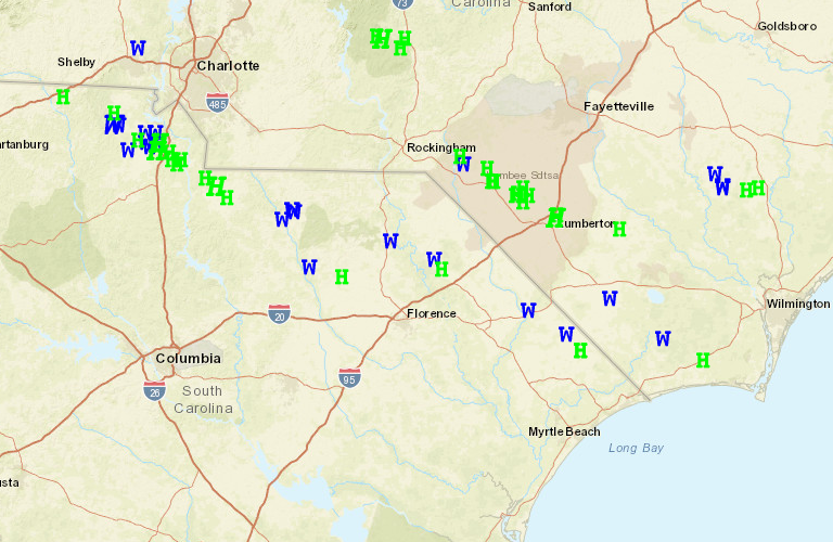
Map of reports of wind damage (W) and large hail (H) from April 20, 2024 courtesy of the NWS Storm Prediction Center |
Additional Links of Interest
Saturday Storm Brought Wind, Hail Damage to Grand Strand and Pee Dee Areas: WPDE
Hail Storm Causes Some Damage in Parts of Robeson County: WPDE
Summary of individual NWS Local Storm Reports: Iowa State University
Summary of SPC Convective Outlooks, Watches, and Mesoscale Discussions Issued on April 20: SPC
Research & Page Author: Tim Armstrong
Page Last Updated: May 3, 2024


 Coastal Flood