Severe thunderstorms with large hail developed across northeastern South Carolina during the afternoon of Thursday, April 7, 2022. Hailstones ranging from ping pong ball to tennis ball in size fell in a number of locations in and around Conway, north across Loris, and into Tabor City, NC.
The largest hail up to the size of baseballs fell between Galivants Ferry and Bayboro where at least one vehicle and a home were damaged.
Horry County is no stranger to large hail. On May 10, 2011, hailstones the size of softballs were reported from two locations in Conway during a severe thunderstorm. On August 28, 2000, baseball size hail fell in the Wampee community of northeastern Horry County.
|
|
|
|
These severe thunderstorms developed within an unseasonably warm and humid airmass for early April. High temperatures inland from the beaches reached the lower 80s with dewpoints approaching 70 degrees. Cool temperatures aloft associated with an upper level disturbance generated significant instability and allowed the storms to grow over 45,000 feet tall where air temperatures were -75° F. Large hail fell in association with the two strongest storms of the day, both of which displayed transient supercellular characteristics on radar. These two cells merged as they crossed the state line, then weakened. Additional large hail fell across northeastern North Carolina with this same weather system later in the evening.
|
Radar reflectivity and visible satellite animation showing severe thunderstorms during the afternoon of April 7, 2022. Yellow polygons are severe thunderstorm warnings. Lightning strikes are shown in white. |
|
|
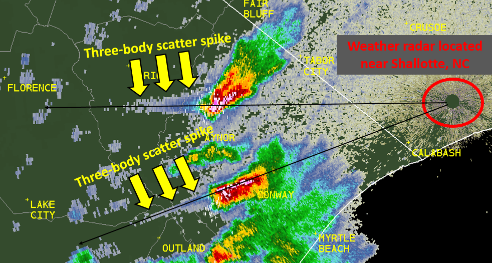
While there are multiple methods available to meteorologists to diagnose the occurrence of large hail, one of the more interesting ones is the appearance of a three-body scatter spike on radar. A three-body scatter spike (TBSS) appears as a "spike" of low reflectivity values extending beyond the thunderstorm as viewed from the radar's perspective. This is an artifact of how radar energy interacts with large hail within the storm. In these situations, a portion of the radar's transmitted energy is reflected by the hailstones down to the ground, then back to the hailstones, then is reflected a third time to the radar receiver. The extra distance the radar energy travels during its bounce between the hailstones, the ground, and the hail again, creates the appearance of a spike of reflectivity extending beyond the storm.
The two strongest storms of the day both showed TBSS signatures on radar, helping meteorologists with their determination large hail was going to occur. Lead times between the warning and the occurrence of hail were as much as 40 minutes during this severe weather event, providing significant time to seek safe shelter.
|
Large hail within two thunderstorm cells over Horry County, SC created three-body scatter spikes on radar. More information on three-body scatter spikes is available at https://courses.comet.ucar.edu/pluginfile.php/3757/mod_imscp/content/1/three_body_scatter_spike.html |
Additional Information
Storm Prediction Center: Storm Reports for April 7, 2022
WMBF: Hail hits Horry County as storms move through area
Research and Page Author: Tim Armstrong
Last Updated: April 8, 2022


 Coastal Flood