
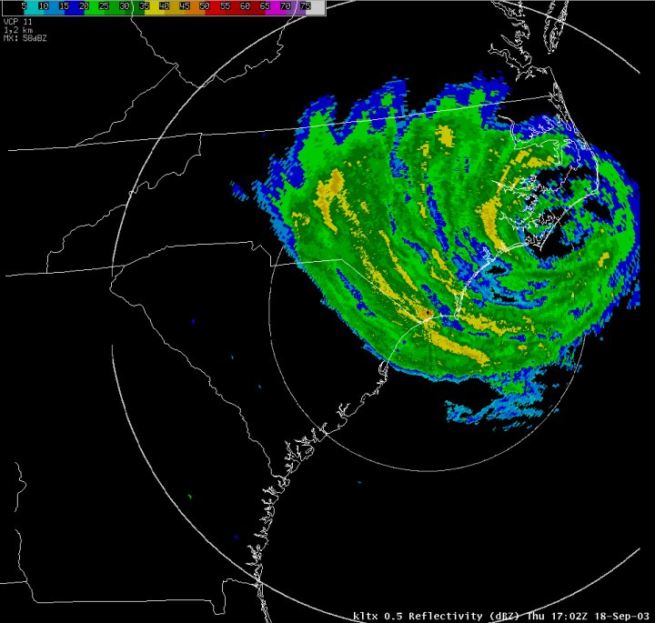
| Event Description
Isabel was identified as a Tropical Storm on Saturday, September 6, 2003 at 9 PM/1300 UTC at 14N 34W, west of the Cape Verde Islands. Moving west-northwest, Isabel developed into a Category 1 Hurricane on Sunday, and strengthened to rare Category 5 Hurricane status (sustained 1-minute wind greater than 155 mph) on Thursday, September 11, 2003. Although Isabel briefly weakened to Category 4 strength it was still a Category 5 storm on Sunday, September 14, 2003, centered 325 miles north of Puerto Rico. Over the next couple of days, Isabel made a slow northwest turn, weakening to Category 3 strength Monday afternoon and Category 2 strength on Tuesday. Isabel continued on a north-northwest course, making landfall on the North Carolina Outer Banks between Cape Lookout and Cape Hatteras on Thursday afternoon, September 18, 2003. Watches/Warnings At 11 AM on Tuesday, September 16, 2003, when the center of Isabel was 600 miles away, a Hurricane Watch was raised for the coast of North Carolina and a Tropical Storm Watch was raised for the South Carolina coast south to the mouth of the South Santee River. At 11 PM, a Hurricane Warning was raised from Cape Fear NC northward, a Tropical Storm Warning was raised from Cape Fear to Little River Inlet SC, with a Tropical Storm Watch remaining from Little River Inlet SC to South Santee River SC...elevated to a Tropical Storm Warning on Wednesday at 11 AM. Following eye landfall, the Hurricane Warning from Surf City NC to Cape Fear NC was lowered to a Tropical Storm Warning, and all warnings south were dropped. At 11 PM, all warnings were dropped along the North Carolina coast. |
|
Actual Track of Isabel (click to enlarge) |
NHC's 5-day Forecast compared to Isabel's actual track (click to enlarge)
|
| Plot of Highest Winds
|
Highest Winds (Note: Official NWS or FAA sites are shaded in gray)
|
||||||||||||||||||||||||||||||||||||||||||||||||||||||||||||||||||||||||||||||||||||||||||||||||||||||||||||||||||||||||||||||||||||||||||||||||||||||||||
|
Rainfall North Carolina
South Carolina
|
|
Lowest Pressure:
NWS Weather Forecast Office Wilmington, NC: 990.5 MB at 1443 EDT.
CMAN FPSN7 Frying Pan Shoals Tower: 993.4 MB at 1300 EDT.
Storm Tides: One-half to One foot above normal.
Beach Erosion: Moderate Erosion in vicinity of Cape Fear (Bald Head Island). Minor Erosion on North Carolina east facing beaches north of Cape Fear, and some sand accretion. None reported elsewhere.
Flooding: Rainwater ponding on roadways mainly in Brunswick and Columbus Counties.
Tornadoes: None.
Storm Effects: Damage described as comparatively minor, including on barrier islands where scattered roof shingles and siding were lost. Across Southeast North Carolina, there were limbs and several trees downed, some on cars and a few houses. There were no damage reports from South Carolina.
Deaths or Injuries: None Reported.
Power: Brief outages, mainly in Southeast North Carolina.
Evacuations: Voluntary along North Carolina barrier islands.
 |
 |


 Coastal Flood