Severe thunderstorms developed across northeast South Carolina during the mid afternoon and moved slowly north into southeast North Carolina, producing hail ranging in size from 0.75 to 1.75 in diameter across Columbus county. Other storms developed across southeast North Carolina and also move north producing hail ranging in size of 0.75 to 2.75 inches and damaging winds across Pender county. A third round of severe weather occurred that evening when additional storms moved southeast across Robeson, Bladen and Columbus counties producing hail ranging from 0.75 to 1.75 inches along with some damaging wind gust. A total of 13 severe thunderstorm warnings were issued for 9 counties in NWS Wilmington's county warning area.
The thunderstorms developed during the afternoon along a trough of low pressure that had migrated into the area and along the sea breeze. The development of severe storms was aided by an upper level system with cold air aloft that was directly over the area. The first report of large hail was received around 3:20 PM as 1 inch diameter hail fell near Tabor City in Columbus county. As other storms developed, several other reports of large hail were received with the largest report of 2.75 inches occurring in Penderlea in Pender county around 4:45 PM. The last report of large hail was received at 9:57 PM when 1.75 inch diameter hail fell in Ash in Columbus county.
Occasional wind damage was reported from some of the storms. The most widespread damage occurred in western Pender county around the time of the large hail during the afternoon. Numerous trees were knocked down and crop damage occured because of the high winds.
The images below show the base reflectivityand vertical integrated liquid (VIL) products from the Wilmington NWS radar. The VIL product gives a look at the total amount of water in a thunderstorm and large values indicate the possibility of large hail.
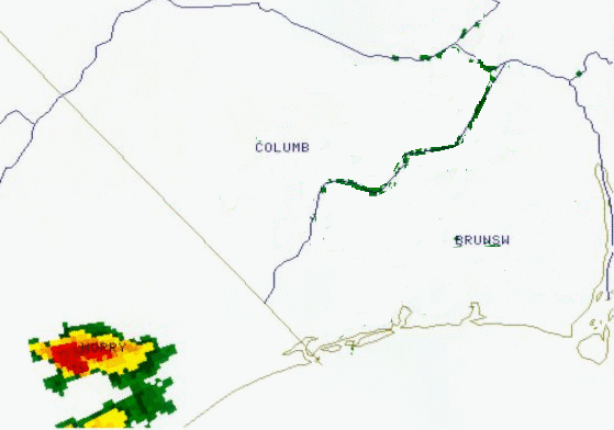
Radar reflectivity loop from 2:14 pm until 3:30 pm. This shows the storms' movement from central Horry County, SC northward into Columbus County, NC.
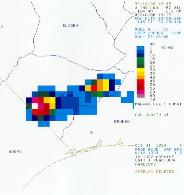
Radar VIL (Vertically Integrated Liquid) image from 3:12 pm
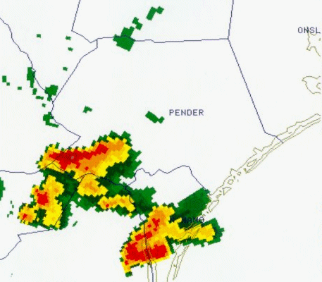
Radar reflectivity loop from 3:53 pm until 4:40 pm, showing the storms' movement across Pender County, NC.
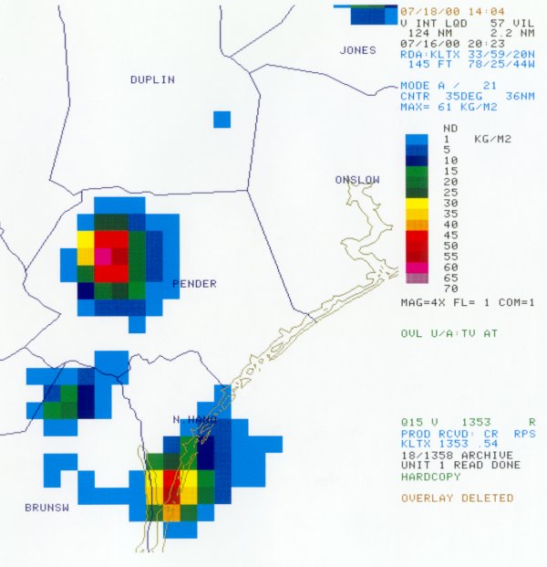
Radar VIL image from 4:23 pm.
PRELIMINARY LOCAL STORM REPORT
NATIONAL WEATHER SERVICE WILMINGTON NC

TIME(EDT)  .....CITY LOCATION.....STATE   ...EVENT/REMARKS...
           ....COUNTY LOCATION....

0320 PM    1 N TABOR CITY            NC   1.00 INCH HAIL
07/16/00   COLUMBUS

0328 PM    TABOR CITY                NC   1.75 INCH HAIL
07/16/00   COLUMBUS

0337 PM    5 S WHITEVILLE            NC   .75 INCH HAIL
07/16/00   COLUMBUS

0355 PM    5 S WHITEVILLE            NC   .75 INCH HAIL
07/16/00   COLUMBUS

0423 PM    WARDS CORNER              NC   1.00 TO 1.25 INCH
7/16/00    PENDER                         HAIL

0435 PM    WATHA                     NC   0.88 INCH HAIL
07/16/00   PENDER

0445 PM    PENDERLEA                 NC   1.75 TO 2.75 INCH
07/16/00   PENDER                         HAIL
                                          WIND GUSTS ESTIMATED
                                          60 MPH
                                          CROP DAMAGE AND LIMBS
                                          SNAPPED OFF TREETOPS
                                          BETWEEN SHILOH RD AND
                                          PENDERLEA HWY

0455 PM    WILLARD                   NC   WIND DAMAGE
07/16/00   PENDER                         NUMEROUS TREES
                                          AND LIMBS DOWN

0720 PM    20 NW ELIZABETHTOWN       NC   1.00 INCH HAIL
07/16/00   BLADEN                         BLADEN/CUMBERLAND
                                          COUNTY LINE NEAR
                                          DUART

0727 PM    DUART                     NC   1.75 INCH HAIL
07/16/00   BLADEN                         REPORTED BY OFF DUTY
                                          OFFICER

0800 PM    ST PAULS                  NC   1.75 INCH HAIL
07/16/00   ROBESON                        BIG SIZE DUMPSTERS BLOWN
                                          OVER

0800 PM    BARKER TEN MILE           NC   .75 INCH HAIL
07/16/00   ROBESON

0811 PM    5 E LUMBERTON             NC   .75 INCH HAIL
07/16/00   ROBESON

0820 PM    BLADENBORO                NC   .75 TO 1.75 INCH HAIL
07/16/00   BLADEN                         REPORTED BY COUNTY SHERIFF

0820 PM    TAR HEEL                  NC   .75 TO 1.75 INCH HAIL
07/16/00   BLADEN                         REPORTED BY COUNTY SHERIFF

0920 PM    LAKE WACCAMAW             NC   1.75 INCH HAIL
07/16/00   COLUMBUS

0954 PM    OLD DOCK                  NC   1.75 INCH HAIL
07/16/00   COLUMBUS

0954 PM    NAKINA                    NC   1.75 INCH HAIL
07/16/00   COLUMBUS

0954 PM    ASH                       NC   1.75 INCH HAIL
07/16/00   COLUMBUS


 Coastal Flood