 An intense low pressure system brought 2 to 8 inches of snow to much of northeast South Carolina and southeast North Carolina late Monday night and early Tuesday. The storm developed off the Georgia coast early Monday morning, rapidly intensifying as it tracked northeast.
Precipitation began as rain across the area on Monday as temperatures hovered in the upper 30s. With temperatures expected to drop to around 32 degrees overnight, NWS forecasters knew that a mix of winter precipitation was likely, and issued a Winter Weather Advisory at 4 PM EST.
As the low moved off the South Carolina coast Monday afternoon, strong northerly winds began to usher in cold Canadian air. By Monday evening, the rain had mixed with sleet across portions of Darlington, Marlboro and Florence counties in South Carolina. By 1 AM EST, the changeover to snow had occurred at the official National Weather Service observation sites in Florence, SC and Lumberton, NC. Shortly after 4 AM EST, the rain had changed to snow at the NWS office in Wilmington, NC.
The Winter Weather Advisory was upgraded to a Winter Storm Warning for Darlington, Marlboro and Florence counties at 3:34 AM EST Tuesday, with expectations of 3 to 6 inch snowfall accumulations.
As moderate to heavy snow continued, the Advisory was upgraded to a Warning for the rest of southeastern North Carolina and northeastern South Carolina with the exception of Williamsburg and Georgetown counties, where the Winter Weather Advisory remained in effect.
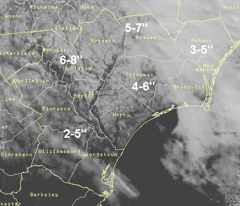
The snow came to an end from west to east on Tuesday, with total accumulations ranging from 2 to 4 inches along the coast to 6 to 8 inches across parts of Darlington, Florence, Dillon, Marion, Marlboro and Robeson counties. The NWS office in Wilmington measured 5 inches when all was said and done.
PUBLIC INFORMATION STATEMENT
NATIONAL WEATHER SERVICE WILMINGTON NC
1115 AM EST TUE JAN 25 2000

HERE ARE THE LATEST SNOWFALL ACCUMULATIONS ESTIMATED FROM EMERGENCY
MANAGERS AND COUNTY SHERIFFS DEPARTMENTS BETWEEN 1030 AND 1100 AM.

NORTH CAROLINA...

ROBESON COUNTY...6 TO 7 INCHES.
COLUMBUS COUNTY...4 INCHES.
PENDER COUNTY...3 TO 4 INCHES.
NEW HANOVER COUNTY...5 INCHES.
BRUNSWICK COUNTY... 4 TO 5 INCHES.
BLADEN COUNTY...4 TO 6 INCHES.

SOUTH CAROLINA....

DARLINGTON COUNTY...5 TO 8 INCHES.
FLORENCE COUNTY...6 TO 8 INCHES.
DILLON COUNTY...6 TO 8 INCHES.
HORRY COUNY...4 TO 6 INCHES.
GEORGETOWN COUNTY...2 TO 5 INCHES.
WILLIAMSBURG COUNTY...3 TO 4 INCHES
MARION COUNTY...6 TO 8 INCHES.
MARLBORO COUNDY...3 TO 4 INCHES
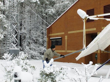
An NWS employee cleaning heavy snow off our satellite communications dish by the weather office.


 Coastal Flood