Severe Weather Awareness Week may not begin until February 20, but an outbreak of thunderstorms during the early morning hours of Monday, February 14, has shown residents of the Carolinas that severe weather can strike at any time of the year.
The same potent storm system that spawned killer tornadoes across Georgia Sunday night triggered numerous strong and severe thunderstorms across the eastern Carolinas early Monday morning. Warm and unstable air was drawn into the area Sunday night as a strengthening low pressure system tracked from Arkansas to Pennsylvania. At the same time, a disturbance in the upper-levels of the atmosphere was moving east from Arkansas, across the Gulf Coast states toward South Carolina.
A well-organized line of strong storms tracked across South Carolina north of Columbia before moving into western sections of the NWS Wilmington County Warning Area (CWA) after midnight. Although these storms were quite impressive on WSR-88D radar, no wind damage or large hail was being reported as they approached Darlington and Marlboro counties.
Additional strong storms developed ahead of this line, to the west of Charleston, SC, and radar suggested that they contained winds well in excess of 58 mph... meeting one of the NWS definitions of a severe thunderstorm. After coordinating with the NWS office in Charleston, SC, concerning the history of these storms, the first Severe Thunderstorm Warning was issued by the NWS in Wilmington at 4:07 AM for Williamsburg County, SC. Although no wind damage reports were initially received, the fast-moving storm was headed for Horry County and the highly populated area of Myrtle Beach. Therefore a Severe Thunderstorm Warning was issued for Horry County at 4:43 AM. At 4:37 AM, a Special Marine Warning was raised from Surf City, NC to South Santee River, SC to alert mariners to the severe weather threat.
By this time, storms were developing rapidly to the southwest and moving northeast at 55 to 65 mph. The NWS Storm Prediction Center in Norman, OK issued Tornado Watch #31 at 4:49 AM, which included all of the NWS Wilmington CWA. A third Severe Thunderstorm Warning was issued at 4:54 AM, as one of the storms was bearing down on Georgetown County, SC. By 5:00 AM, a solid line of storms had begun to fill in from Myrtle Beach to Lake Waccamaw. Severe Thunderstorm Warnings were issued for Columbus, Brunswick, New Hanover and Pender counties in North Carolina at 5:04 AM.
At 5:55 AM, a collapsing storm off the Brunswick county coast prompted a Severe Thunderstorm Warning for Brunswick and New Hanover counties as potentially damaging winds were headed towards Long Beach, Holden Beach, Southport and southern Wilmington. At 8:36 AM, the Storm Prediction Center cancelled Tornado Watch #31, but the excitement wasn't quite over. At 8:44 AM, another storm was making a beeline for Georgetown county at 70 mph, and another Severe Thunderstorm Warning was issued.
A wind gust of 68 mph was measured by a HAM Radio operator and Skywarn Observer in Pender county at 5:10 AM. At 5:36 AM, a wind gust to 62 mph was recorded at the NWS office at Wilmington International Airport. Observing equipment in North Myrtle Beach recorded a gust to 52 mph at 5:01 AM.
Tornado Watch #32 was issued for southeastern North Carolina and a good portion of South Carolina at 1:45 PM. A few severe thunderstorms and a possible tornado occurred late Monday afternoon in the NWS Charleston CWA, however no strong or severe storms threatened the Wilmington CWA. The western counties were cleared from the watch at 4:50 PM, and the watch expired quietly for the rest of the area at 7:00 PM Monday evening.

Radar picture 1: A line of strong thunderstorms move into Darlington and Marlboro counties in South Carolina

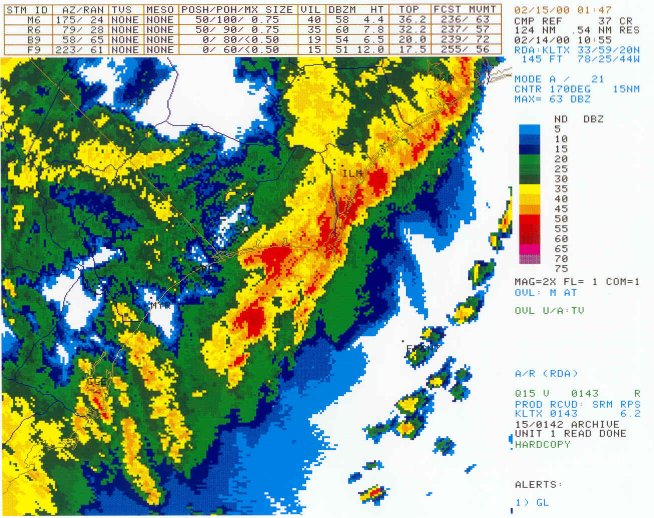
Radar picture 2: Storms strengthened as they moved closer to the coast
Radar picture 3: Two strong thunderstorms off the Brunswick County, NC coast move north toward land.


 Coastal Flood