NWS Wilmington, NC
Weather Forecast Office
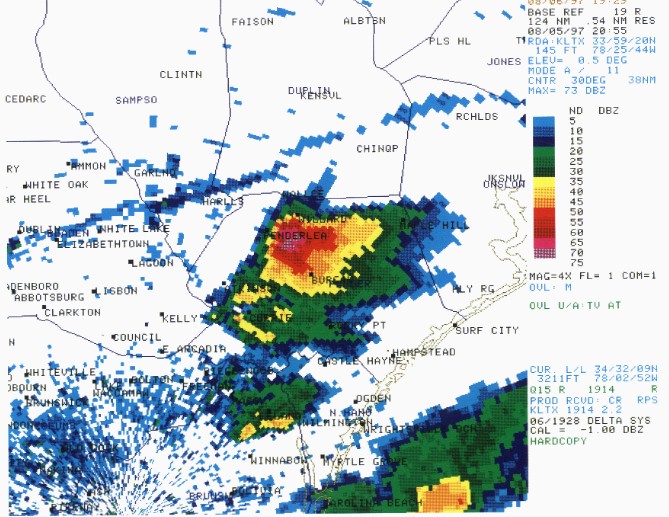
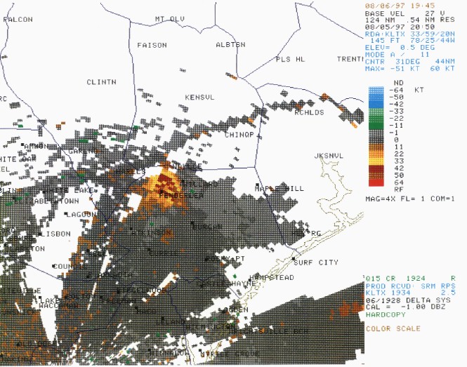
During the late afternoon of Tuesday, August 5th, several severe storms were moving across portions of southeast North Carolina and northeast South Carolina. The most significant of these turned out to be a storm that first develop over western Columbus county in North Carolina. While most of the storms on this afternoon were moving almost due east, this storm deviated from this pattern and moved to the northeast throughout its life cycle. This northeast movement enable the storm to maximize the energy available in the atmosphere and turn this energy into damaging winds and hail. The first damage reports came in around 4 PM from the Kelly area of southeast Bladen county where trees were blown down and quarter sized hail fell. The storm then weakened some as if moved across the western sections of Pender county before intensifying again near Piney Woods. From here a damage track 5 miles wide and 20 miles long occurred through the town of Watha northeast toward the Holly Shelter wildlife refuge. Within in this damage track, hail the size of tennis balls was reported along with wind speeds estimated well over 60 miles an hour. Six structures were totally destroyed, 20 sustained major damage, 71 others has minor damage and crops were destroyed. The total damage estimate to both structures and crops is around $3.5 million. The reflectivity image below is from the Wilmington doppler radar at 4:55 PM 8/5/97. The supercell storm is located over northern Pender county, just southeast of Penderlea, where extensive damage was done to structures in the Watha area. Below the reflectivity image is a velocity image from the Wilmington doppler radar at 4:50 PM. The areas shaded in red indicate radar estimates of wind speeds around 55 miles an hour, however, due to the storms movement relative to the radar, it is possible that wind speeds were actually higher than this.
Forecasts
Local Forecasts
Marine
Tropical
Graphical
Aviation
Rain and Rivers
Fire Weather
Discussion
Beach, Rip Current and Surf
Rip Current Risk
Surf Forecast
Coastal Flood
Weather Activity Planner
Forecast Graph/Tab/Text
Model Guidance
Hazards
Mobile Weather
Briefing Page
Local Hazards
Hazardous Weather Outlook
Latest Briefing
Social Media Feeds
EM Briefing
NOAA Weather Radio
Submit Storm Report
Current Conditions
Marine Obs (List)
Observations Map
Satellite
Marine Obs (Map)
Local Observations (List)
Regional Temps and Precipitation
Daily Temp and Precip Summary
Radar
NWS Wilmington Radar
Southeast Regional Radar
Enhanced National Radar
National Radar
Past Weather and Hydrology
Local Climate Records
Climate Plots
Local Hydro Information
Rainfall and Rivers
Past Significant Events
Weather History Calendar
US Dept of Commerce
National Oceanic and Atmospheric Administration
National Weather Service
NWS Wilmington, NC
2015 Gardner Drive
Wilmington, NC 28405
(910) 762-4289
Comments? Questions? Please Contact Us.


 Coastal Flood