Winter Storms in Wisconsin
Protect yourself and your family before the first winter storm strikes.
| What Makes a Winter Storm?
Cold air: Below freezing temperatures in the clouds and near the ground are necessary to make snow and ice. Moisture: Needed to form clouds and precipitation. Lift: Something to raise the moist air to form clouds and precipitation, such as a front. |
 |
Where Do Winter Storms Develop?
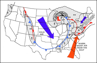
Storms that affect Wisconsin develop over southeast Colorado, northwest Canada, and over the southern Plains. These storms move toward the Midwest and use both the southward plunge of cold air from Canada and the northward flow of moisture from the Gulf of America to produce heavy snow over the region.
"Alberta Clippers," which develop in the lee of the Canadian Rockies and move southeast toward Wisconsin, not only bring accumulating snow, but also strong winds and extremely cold air to the state.
"Lake effect" snowstorms develop as cold air moves across the relatively warmer waters of Lake Michigan and Lake Superior. Moisture from the lakes is then deposited as heavy snow within several miles of the shore.
Winter Storm Climatology
On average, northeast and north-central Wisconsin experiences 3 to 5 winter storms a season and a significant ice storm once every 4 or 5 years.
The average date of the first snowstorm in Wisconsin is November 10. Click here for a chart and map of normal snowfall across the area.
Be Prepared...
Before the Storm Strikes
At home and at work...
Have available:
In cars and trucks...
Plan your travel and check the latest weather reports to avoid the storm. If you do travel:
|
When Caught in a Winter Storm... |
||
| Outside | In a Vehicle | At Home |
Find Shelter:
|
Stay in Your Vehicle and Run the Motor Sparingly:
|
Stay Inside:
|
Additional Information
 Be Informed! -- Winter weather forecasts and advisories from the NWS
 The NWS Weather Awareness Page -- Winter safety and awareness topics