
Isolated heavy rainfall will continue through tonight across portions of central Texas, though some relief from the heavy rain is expected on Tuesday. Heat and humidity will remain in place across the Eastern U.S. and interior Northwest U.S. over the next few days with widespread moderate to major Heat Risk. Dangerous heat will build into the Desert Southwest Tuesday through Thursday. Read More >
On the afternoon of August 12, 2015, a fire erupted at an auto salvage yard on the east side of Green Bay. A news story from the Green Bay Press Gazette summarizing the fire was published here. The fire produced a very dramatic smoke plume that could be seen from some distance, including from our office near Austin Straubel International Aiport on the far west side of Green Bay.
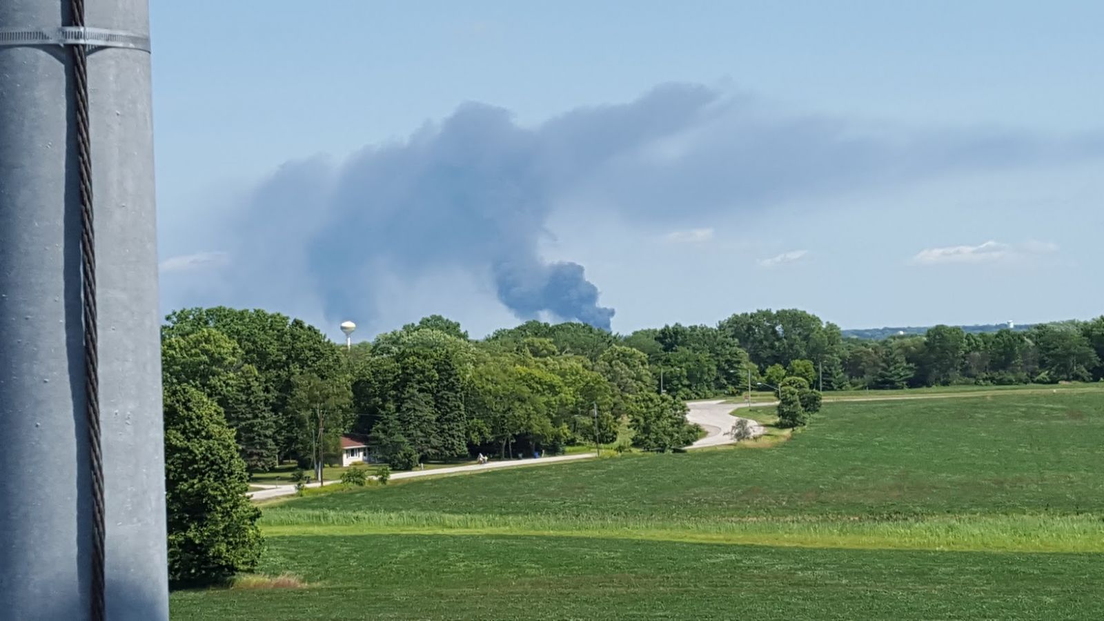 |
| Photo of the smoke plume taken from the NWS office in Green Bay, taken just after 2:30 PM |
But more than eyes were able to observe this smoke plume. The plume was also visible to our radar beginning at 2:05 PM, and continuing until the last traces disappeared around 3:30 PM. Below is a loop of the radar reflectivity from when the plume was most obvious. It's important to note that the actual smoke particles are too small to be sensed well by our radar. What it's actually picking up is tiny pieces of material lofted up by the heat produced by the fire. In this case, it's likely tiny particles of tires and other related materials. Because it was so close to the radar, the plume blends in a little bit with the normal ground clutter around that part of town. Indeed, we're showing images from our second-lowest 1.5° radar sweep, rather than the lowest angle that we typically show, to make the plume stand out a little better.
 |
| Loop of the 1.5° degree radar scan from 1:55 PM until 3:29 PM CDT on August 12, 2015 |
Taking a more in depth look, we can analyze the radar data using our recently added dual polarization capability. For this, we'll examine the radar at 2:44 PM:
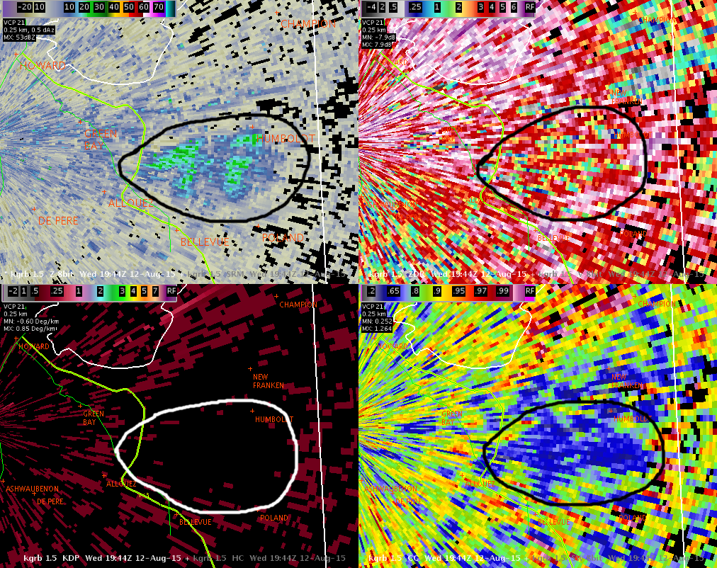 |
| KGRB at 2:44 PM CDT on August 12, 2015. The plume is highlighted with a black/white circle. Clockwise, from upper left: Reflectivity (Z), Differential Reflectivity (ZDR), Correlation Coefficient (CC), and Specific Differential Phase (KDP) |
The upper left panel shows the familiar reflectivity image. One thing that immediately distinguishes it from the ground clutter around it is a look at the correlation coefficient in the lower right panel. The solid patch of very low CC values is different from the other clutter - which has low values, but mostly higher than in the smoke plume. In contrast, precipitation shows up in the CC display at much higher levels, usually above 0.95! This is why CC is very useful in determining whether a radar return is meteorological or not.
Another interesting factor is in the lower left panel, which is KDP. This variable is used to help estimate the intensity of rainfall, and is found in algorithms we use to estimate how much rain has fallen from radar data. It wouldn't help to contaminate these algorithms with echoes that aren't caused by precipitation, so you can see that the plume is blacked out because of its very low CC values. Of course, on a sunny day like today, you can see that this filter doesn't quite eliminate everything. Fortunately, what gets through the filter is minimal enough that it doesn't impact rainfall estimates.
Finally, in the upper right panel, we see what the ZDR looks like for the plume. ZDR can be a very noisy product, especially when the radar is observing non-meteorological returns! But, we can see some subtle differences from the outlined plume and the other clutter around it. Very near the source of the fire, on the left point of the plume, ZDR is very small, with values near 0. This is likely because the observed particles are tumbling in the fire's turbulent updraft, and appear more spherical to the radar. Farther to the east, as the plume blows along with the wind, the objects are likely settling more, and the ZDR becomes larger. This indicates that the particles are longer/wider than they are tall.
Of course, our radar wasn't the only data we monitor that observed the smoke plume. The weather observations from Austin Straubel also noted the smoke! In coded form, these are the reports we received from the airport. The code for smoke is FU, and it's observed northeast of the station, moving to the southeast:
KGRB 122053Z 21007KT 10SM CLR 27/17 A3010 RMK AO2 SLP189 FU NE MOV SE T02670167 56016
KGRB 122019Z 24006KT 10SM CLR 27/17 A3010 RMK AO2 FU NE MOV SE T02670167
KGRB 121953Z 30008KT 10SM CLR 27/17 A3011 RMK AO2 SLP194 FU NE MOV SE T02670167

