|
The first signs of spring occurred on March 6th with highs in the 50s and lower 60s, but the unprecedented warmth across north-central and northeast Wisconsin occurred from March 10th through March 24th. In the Green Bay forecast area which covers 22 counties across north-central and northeast Wisconsin, at least one location reported a record high temperature or record high minimum temperature on every day between the 10th and 24th except for the 13th. On the 13th, a cold front that moved across the area the night before brought temperatures closer to normal. The peak of the heat wave occurred from the 14th to the 24th when daily departures from normal ranged from 25 to 40 degrees above normal. On the 20th, Green Bay averaged 37 degrees above normal for the date. This established a new record for the greatest daily above normal temperature departure for any single date since records began in 1886. The old record of 34 degrees above normal occurred on March 8, 2000. More record highs were reported on the 27th at Marshfield.
Many daily record high temperatures and record high minimum temperatures were broken by 10 to 20 degrees between the 14th and 24th. Many locations also reported the earliest 80 degree temperature for so early in the year. Many sites also recorded the most number of days above 60, 70 and 80 degrees during the month of March. Usually during the spring, night time lows fall back into the 40s due to the cooler ground, longer nights or the cooling effects of the lake-breeze off the Bay of Green Bay or Lake Michigan. During this warm spell, this was not the case as most sites away from the bay and lake reported lows well into the 50s to around 60. At Wausau, the low temperature of 60 on the 21st was the earliest low temperature of 60 degrees. The previous earliest low temperature of 60 was 62 degrees on April 16th, 1921 or nearly a month later than the newly established record. It was the same story for Wisconsin Rapids which reported a low of 60 degrees on the 21st. The previous earliest low temperature of 60 degrees was 64 degrees on April 15, 1929. The combination of unseasonably warm days and mild nights allowed for many loca-tions to record a number of cooling degree days for the month of March. As a matter of fact, some sites reported the 1st cooling degree ever during the month of March. The above normal tempera-tures came to an end on the 29th and 30th.
Overall, March 2012 will go down in the record books as the warmest March on record. Depar-tures from normal were from 14 to 17 degrees above normal for the month away from the Bay of Green Bay and Lake Michigan. Temperatures near the bay and lake averaged 10 to 13 degrees above normal for the month. Most locations broke their previous warmest March on record by an astound-ing 4 to 6 degrees!
The main impacts of the extremely warm March were to agricultural interests. The green up and flowering of plants occurred 4 to 6 weeks earlier than normal.
The early warmth concerned area growers due to the potential for a hard freeze later in the spring which would cause significant damage to crops. Also, the National Weather Service in Green Bay began to issue freeze advisories in late March when temperatures were expected to fall to 28 degrees or lower. The freeze headlines normally do not start until late April or early May. During the ex-tremely warm stretch of weather, several grass fires were reported across the area. One of these fires forced Interstate 43 to shut down near Green Bay for a short period of time. One benefit of the unprecedented warm was that less fuel was used to heat homes during the month.
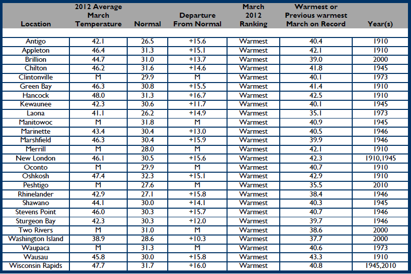
Temperature Summary for Green Bay Area March 1-31, 2012
Observed daily maximum and minimum temperatures for March 2012 are connected by dark blue bars. Normal maximum and minimum temperatures are shaded in yellow. Red line connects record high temperatures. Blue line connects record low temperatures.
--
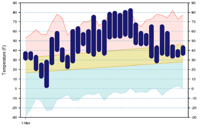
Temperature Summary for Wausau downtown airport. March 1-31, 2012
Observed daily maximum and minimum temperatures for March 2012 are connected by dark blue bars. Normal maximum and minimum temperatures are shaded in yellow. Red line connects record high temperatures. Blue line connects record low temperatures.
The National Weather Service office in La Crosse, Wisconsin collected data for the southwest part of Wisconsin. You can find the article here. |
 |
Media use of NWS Web News Stories is encouraged! Please acknowledge the NWS as the source of any news information accessed from this site. |
|