Overview
|
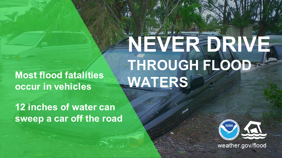
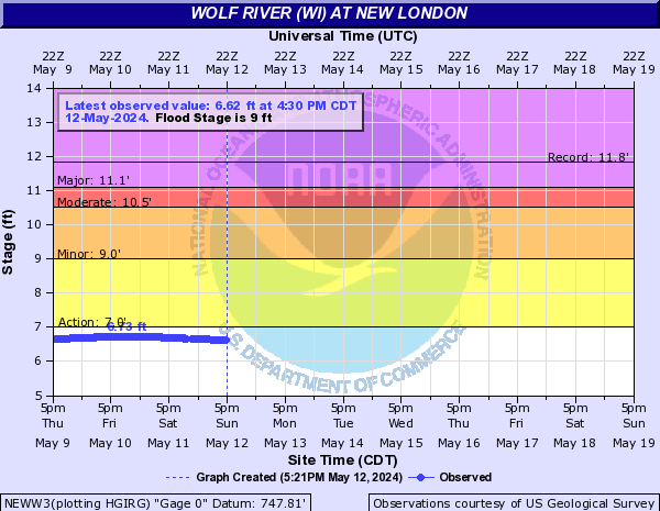
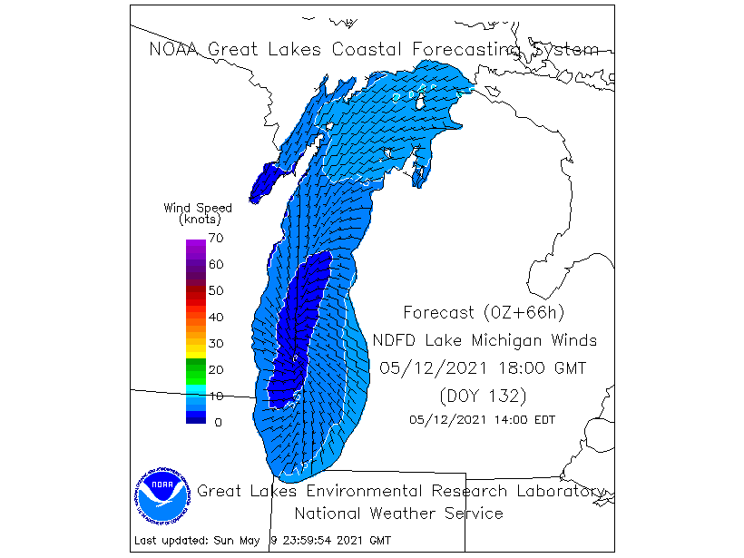
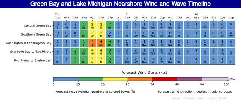
Snow / Ice / Wind: Snow and sleet will continue across northern WI into this evening, changing over to freezing rain later tonight. Up to 2" of additional snow is possible. Farther south, a mix of rain, freezing rain, and sleet is expected through the evening, changing to mainly rain. Ice accumulations up to 0.15" will also be possible, highest across central and north-central Wisconsin. In addition to the wintry precipitation, winds of 15 to 25 mph with gusts near 35 mph will continue into this evening. The strong wind could create ice shoves along the west shores of the Bay and Lake Winnebago. Flooding: Due to recent snow melt, plus the forecast snow/rain, river flooding will remain possible across the area through the weekend. If you are in a flood prone area, be prepared for rapidly changing conditions. Remember, if you come upon a flooding roadway...Turn Around, Do Not Drown! Please visit our river page for the latest river stages and forecasts. Severe Weather: Severe weather is not expected at this time. However, a few storms are possible, especially across central and east-central Wisconsin into this evening. Gusty winds and small hail are the main threats from the storms. Marine: Winds up to 30 knots with gale force gusts to around 35 knots through this evening. The strong winds will generate waves of 6 to 10 feet on Lake Michigan. Much of Green Bay remains ice-covered, however ice free areas will see waves up to 3 feet. Be sure to check back for the latest forecast.
Please click on the tabs below for more information. Click on any image for a larger view. |
The science of how different precipitation types form
|
Latest Watches & Warnings
|
|
 Current Watches, Warnings, & Advisories Current Watches, Warnings, & Advisories |
|
 National Hazards Map (click map for more info) National Hazards Map (click map for more info) |
 Current Convective Watches Current Convective Watches |
Snow / Rainfall Forecasts / Flooding
|
Latest Snowfall Forecast |
|||
|
|
 WPC Rainfall Forecast Day 2 (more info) WPC Rainfall Forecast Day 2 (more info) |
 WPC Rainfall Forecast Day 3 (more info) WPC Rainfall Forecast Day 3 (more info) |
 WPC Rainfall Forecast Days 1-3 (more info) WPC Rainfall Forecast Days 1-3 (more info) |
 WPC Excessive Rainfall Day 1 (discussion) WPC Excessive Rainfall Day 1 (discussion) |
 WPC Excessive Rainfall Day 2 (discussion) WPC Excessive Rainfall Day 2 (discussion) |
 WPC Excessive Rainfall Day 3 (discussion) WPC Excessive Rainfall Day 3 (discussion) |
 WPC Mesoscale Precip Discussions (more info) WPC Mesoscale Precip Discussions (more info) |
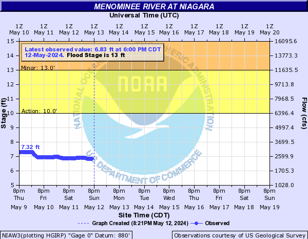
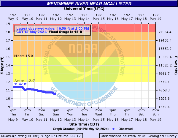
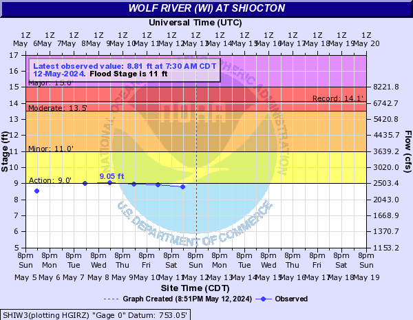
| Current River Stages and Forecasts (click here for additional locations) | |
 |
 |
 |
 |
|
SPC Outlooks
 Day 1 (discussion) Day 1 (discussion) |
 Day 1 Tornado Probabilities Day 1 Tornado Probabilities |
 Day 1 Hail Probabilities Day 1 Hail Probabilities |
 Day 1 Wind Probabilities Day 1 Wind Probabilities |
 Day 2 (discussion) Day 2 (discussion) |
 Day 2 Probabilities Day 2 Probabilities |
 Day 3 (discussion) Day 3 (discussion) |
 Day 3 Probabilities Day 3 Probabilities |
 Mesoscale Discussions (more info) Mesoscale Discussions (more info) |
 Severe Storm Risk Categories Severe Storm Risk Categories |
|
Radar & Satellite
| Radar Data | ||
 |
|
|
|
|
||
    |
||
| Satellite Imagery | ||
|
Visible (Click here for LOOP) |
|
|
Snow and Severe Weather Reports
|
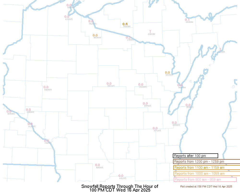
Latest Snow Reports |
For the latest Wisconsin road conditions, visit: |
|
Today's Storm Reports |
Yesterday's Storm Reports |
 |
Media use of NWS Web News Stories is encouraged! Please acknowledge the NWS as the source of any news information accessed from this site. |
|


.png)