
Thunderstorms, some severe, may produce heavy to excessive rainfall and isolated flooding over portions of the Southern Plains today and Saturday. Dry conditions, combined with gusty winds and low relative humidities will continue to support an elevated to critical fire weather threat in the Desert Southwest into to early next week. Read More >
Thunderstorms produced a widespread soaking rainfall across much of Wisconsin Wednesday night. The heaviest rains fell in central through southwest Wisconsin. The far north and northeast portions of the state received much lighter rains.
| Radar Rainfall Estimates from mid-day Tuesday through Thursday Morning |
 |
Here is a list of rainfall reports received by the National Weather Service in Green Bay.
NOUS43 KGRB 221557
PNSGRB
PUBLIC INFORMATION STATEMENT
NATIONAL WEATHER SERVICE GREEN BAY WI
1057 AM CDT THU SEP 22 2016

                        rainfall amounts ending around 7 am
                          last      previous       2 day
                          24hrs      24 hrs        total
Location
......North central wisconsin......
...Vilas county...
phelps dnr                0.44       0.00          0.44
Phelps WWTP               0.40       0.00          0.40
Eagle River south         0.70       0.00          0.70
Phelps-L Vieux Desert     0.40       0.00          0.00
Rest Lake                 0.80       0.00          0.00
Arbor Vitae Johnson Lake  0.79          T          0.79

...Oneida county...
Rhinelander Airport       1.39       0.04          1.43
woodruff dnr              1.06       0.00          1.06
Rhinelander 4E-LK Thomps  1.28       0.02          1.30
Tomahawk 7NW HAM          0.91       0.00          0.91
Minocqua                  0.90       0.00          0.90
Rhinelander 4NE           1.24       0.02          1.26
Lake Tomahawk-2SE         1.21          T          1.21

...Lincoln county...
merrill 5ne usgs          1.38       0.02          1.40
tomahawk dnr              0.74       0.02          0.76
Tomahawk-Rice Reservoir   0.86       0.00          0.86
Merrill 8W                1.15       0.20          1.35

......Northeast wisconsin......
...Forest county...
laona dnr                 0.75       0.00          0.75
Argonne 2NW               1.13          T          1.13

...Florence county and adjacent portions of upper michigan...
fence 3nw usgs/we         0.62       0.00          0.10

...Marinette county...
wausaukee dnr 1nw         0.37       0.01          0.38
Marinette                 0.73       0.02          0.75
Amberg 9E                 0.35       0.00          0.35
Crivitz WPS               0.49       0.00          0.49
Crivitz High Falls        0.55          T          0.55

...Langlade county...
antigo dnr                1.15       1.15          3.30
Antigo COOP               1.19       0.10          1.29
White Lake 1SE            0.80       0.06          0.86
Summit Lake               1.01       0.05          1.06

...Oconto county...
Suring WWTP               0.72       0.06          0.78
Oconto Radio WOCO         0.86       0.08          0.94
Stiles 1S                 0.91       0.24          1.15
Mountain 1SW              0.66       0.09          0.73


......Central wisconsin......
...Marathon county...
Wausau Airport            1.33       0.06          1.39
mead dnr                  1.38       0.50          1.88
Dancy 1NE                 1.58       0.72          2.29
Spencer WWTP              2.51       0.29          2.80
Wausau Northeast          1.30       0.06          1.36
Mosinee 2N HAM            1.35       0.24          1.59
Stevens Point-8NE Poloni  1.37       0.64          2.01

...Wood county...
Wisconsin Rapids ASOS     2.38       0.60          2.98
Marshfield ASOS           1.96       0.63          2.59
nekoosa-6se rome dnr      3.25       0.70          3.95
Marshfield Exp Farm       2.27       0.50          2.77
Pittsville                2.99       0.91          3.90
Wisconsin Rapids SE       2.52       0.73          3.25
Wisconsin Rapids          2.37       0.80          3.17

...Portage county...
Almond 5NE                2.37       0.52          2.89
Amherst 3SE               1.67       0.73          2.40
Plover south              1.84       1.22          3.06
Plover HAM                1.62       1.08          2.70
Plover-2E Water Treatmen  1.52       0.96          2.48
Stevens Point             1.64       0.60          2.24
Stevens PT-Whiting HAM    1.58       0.82          2.40
Junction City 4S HAM      2.58       0.99          3.57
...Waupaca county...
new london usace          1.81       0.17          1.98
waupaca usace             2.34       0.49          2.83
Clintonville WWTP         1.91       0.18          2.09
New London WWTP           1.96       0.25          2.21
Waupaca WDUX RADIO        2.06       0.38          0.38


......East central wisconsin......
...Shawano county...
Pella 3SE                 1.49       0.11          1.60
Cecil 6NE-Pulcifer        1.09       0.18          1.27
Shawano-4SE               1.29       0.24          1.53
Shawano COOP              1.30       0.16          1.46

...Outagamie county...
Appleton                  1.39       0.20          1.59
Shiocton                  1.81       0.14          1.95

...Brown county...
Denmark WWTP              0.96       0.20          1.16
Pulaski WWTP              1.14       0.14          1.28

...Winnebago county...
oshkosh-lk butte d. mrt   1.30       0.28          1.58
menasha-jef park usace    1.20       0.19          1.39
Oshkosh WWTP              1.72       1.32          3.04
Omro 2SW                  2.11       0.98          3.09
Oshkosh 5N                1.40       1.73          3.13
Oshkosh north             1.73       1.42          3.15

...Calumet county...
stockbridge-l win.        0.57       0.49          1.06
Brillion WWTP             1.30       0.35          1.30
Chilton WWTP              1.04       1.23          2.27
New Holstein WWTP         0.82       1.27          2.09


...Kewaunee county...
Casco                     0.71       0.25          0.25
Kewaunee southwest        0.83          T          0.83
Kewaunee WWTP COOP        0.62       0.25          0.87

...Manitowoc county...
Two Rivers                0.53       0.18          0.71
Francis Creek             0.79       0.16          0.79
ST. Nazianz 2W            0.71       0.85          1.56


$$
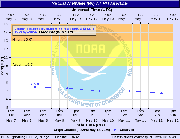
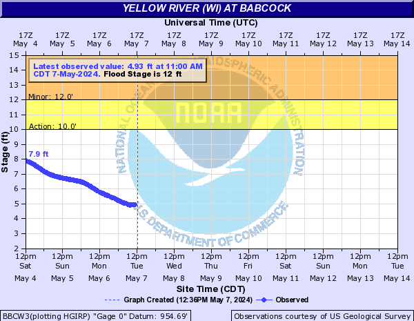
River levels will rise the next few days as the runoff from the rains work through river systems. Flood warnings are in effect for the Yellow River in Wood county, where the river is expected to crest in the next 24 hours.
 |
|
 |
Here are some additional links to help monitor the weather:

