Overview
|
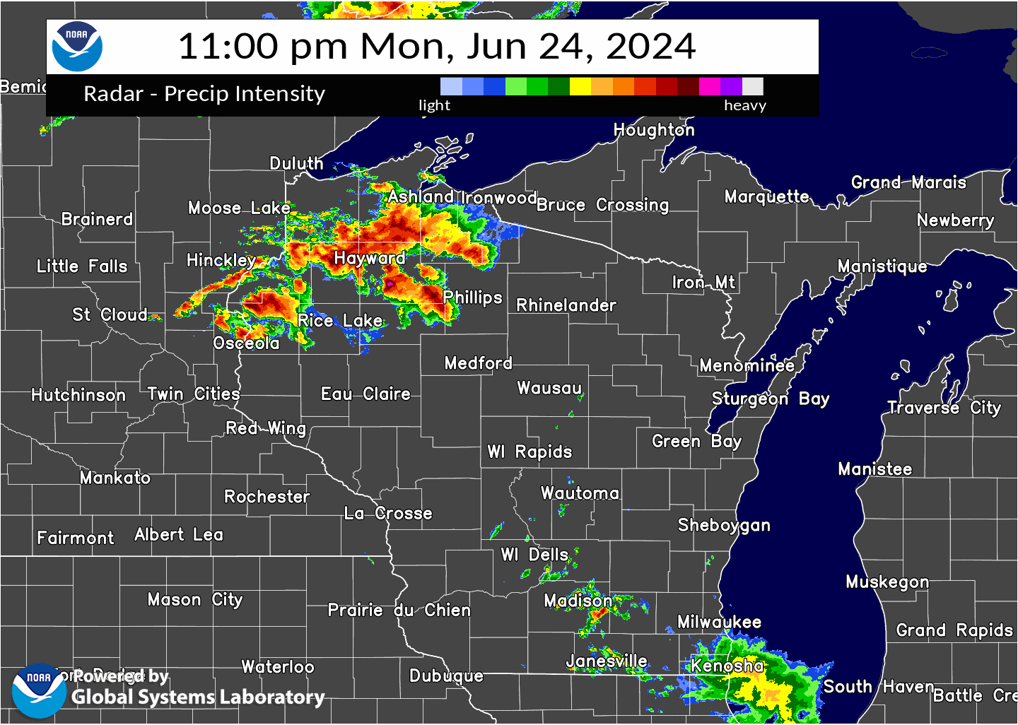
Severe thunderstorms swept across much of northeast Wisconsin late on June 24, 2024, into the early morning hours of June 25, 2024. A complex of storms developed across western Wisconsin, consolidated, and then raced southeast across the area between midnight and 5am. A few storms developed ahead of the line, producing some large hail and brief gusty winds as well. The main line of storms had an impressive forward speed of 40 to 70 mph. The most concentrated wind damage was reported from Lincoln County to Manitowoc County. The storms uprooted and knocked down trees and power lines, causing thousands of customers to lose power. The highest observed wind reports were at the Green Bay Airport with 61 mph, and at the Manitowoc Airport with 58 mph. Minor flooding was also reported across the area. The worst flooding occurred in southern Door County east of Forestville, where a road was partially washed out. This coincides with the highest observed rainfall report of 3.80 inches, measured 4 miles East of Forestville. NWS Green Bay conducted storm damage surveys across portions of the area. It was concluded there was 1 tornado in Menominee County, rated as an EF1.
Please click on the tabs below for more information. |
 |
A Favorable Environment for Severe Thunderstorms
|
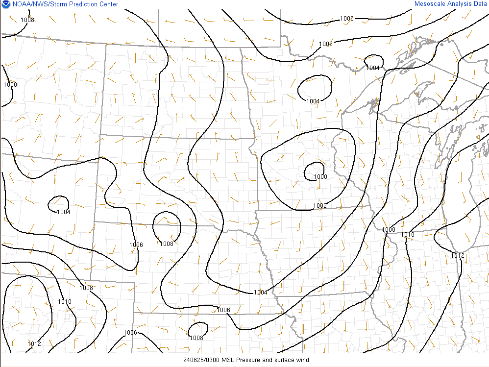
In advance of a surface low pressure, an influx of warm and moist air
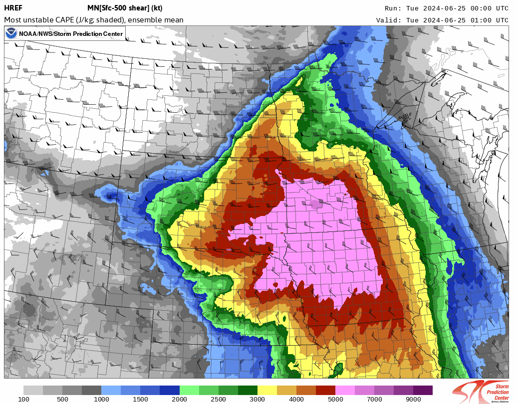
set the stage for thunderstorm development over northwest Wisconsin by late in the evening of June 24, 2024. These thunderstorms developed in a region of increasingly unstable air characterized by most unstable cape values upwards of 4000 j/kg.
Winds aloft were relatively strong for this time of the year with 40 to 60 kts of west to east flow at 500mb over northern Wisconsin. This strong deep layer shear was favorable for thunderstorms to become organized into a potent squall line, which tracked from northwest to southeast across northern Wisconsin.
|
 RAP Mean Sea Level Pressure from 10 pm June 24 to 7 am June 25 |
|
|
HREF Most Unstable Cape from 8 pm June 24 to 7 am June 25 |
Tornado Listing
|
Keshena to Berry Lake -
Track Map 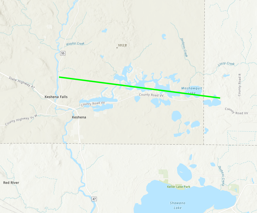 
|
|||||||||||||||||||
| EF0 Weak 65-85 mph |
EF1 Moderate 86-110 mph |
EF2 Significant 111-135 mph |
EF3 Severe 136-165 mph |
EF4 Extreme 166-200 mph |
EF5 Catastrophic 200+ mph |
 |
|||||
Storm Reports
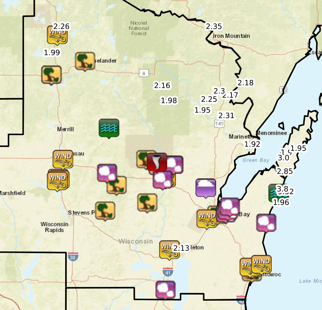 |
|
| Storm Reports on June 25, 2024 |
PRELIMINARY LOCAL STORM REPORT...SUMMARY
NATIONAL WEATHER SERVICE GREEN BAY WI
550 PM CDT Tue Jun 25 2024
..TIME... ...EVENT... ...CITY LOCATION... ...LAT.LON...
..DATE... ....MAG.... ..COUNTY LOCATION..ST.. ...SOURCE....
..REMARKS..
1219 AM Tstm Wnd Gst 2 S Minocqua 45.84N 89.69W
06/25/2024 M51 MPH Oneida WI Public
0202 AM Tstm Wnd Gst Wausau Downtown Airport 44.93N 89.63W
06/25/2024 M56 MPH Marathon WI ASOS
0220 AM Tstm Wnd Gst 1 ENE Shawano 44.79N 88.56W
06/25/2024 E44 MPH Shawano WI AWOS
0220 AM Tstm Wnd Gst 1 NE Mosinee 44.79N 89.68W
06/25/2024 E65 MPH Marathon WI Public
Also had 1/2 inch hail.
0220 AM Tstm Wnd Gst 1 S Mosinee 44.77N 89.69W
06/25/2024 M43 MPH Marathon WI Public
South Shantytown.
0235 AM Tstm Wnd Gst 1 E Mosinee 44.78N 89.67W
06/25/2024 M46 MPH Marathon WI ASOS
0304 AM Tstm Wnd Gst 3 W Ashwaubenon 44.49N 88.13W
06/25/2024 M61 MPH Brown WI ASOS
At Austin Straubel International Airport.
0335 AM Tstm Wnd Gst 2 SSE Greenville 44.26N 88.52W
06/25/2024 M53 MPH Outagamie WI Public
At Appleton International Airport.
0339 AM Tstm Wnd Gst 3 SW Shoto 44.13N 87.68W
06/25/2024 M58 MPH Manitowoc WI ASOS
At Manitowoc Airport.
0340 AM Tstm Wnd Gst Two Rivers 44.15N 87.56W
06/25/2024 M42 MPH Manitowoc WI Trained Spotter
0111 AM Tstm Wnd Dmg 1 NNE Rhinelander 45.65N 89.40W
06/25/2024 Oneida WI Broadcast Media
Corrects previous tstm wnd dmg report from 1
NNE Rhinelander. Multiple trees down across
Rhinelander.
0120 AM Tstm Wnd Dmg 1 N Bradley 45.55N 89.75W
06/25/2024 Lincoln WI NWS Storm Survey
*** 2 INJ ***
Widespread large trees uprooted and snapped
along the south shore of Lake Nokomis. Some
trees fell onto roofs and a tree fell into a
cabin causing it to collapse where two
injuries occurred. Preliminary indications
from NWS survey suggest damage was caused by
straight line winds.
0120 AM Tstm Wnd Dmg 1 NNW Bradley 45.55N 89.75W
06/25/2024 Lincoln WI 911 Call Center
*** 2 INJ ***
Trees down on cabin causing the cabin to
collapse. 2 injuries reported.
0220 AM Tstm Wnd Dmg 4 NE Morgan 44.93N 88.76W
06/25/2024 Shawano WI Public
Multiple trees uprooted near Big Lake.
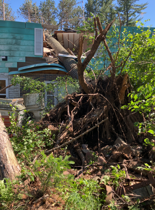
0227 AM Tstm Wnd Dmg Keshena 44.88N 88.63W
06/25/2024 Menominee WI Public
Uprooted trees and a tree down on house
along with broken power poles. Via social
media.
0228 AM Tstm Wnd Dmg Keshena 44.88N 88.63W
06/25/2024 Menominee WI Public
Multiple trees snapped and broken in the
Keshena areas. Photos of trees onto some
houses and garages and power poles knocked
down. Via social media.
0228 AM Tstm Wnd Dmg 5 E Keshena 44.89N 88.52W
06/25/2024 Menominee WI Public
Along Legend Lake. Hundreds of trees down.
0229 AM Tstm Wnd Dmg 5 W Underhill 44.89N 88.48W
06/25/2024 Oconto WI Public
At Berry Lake. Campers flipped, docks
missing. Downed trees all around the lake.
Via social media.
0230 AM Tstm Wnd Dmg Tigerton 44.74N 89.07W
06/25/2024 Shawano WI Public
Trees down with building damage at Tigerton
Historical Society in Tigerton. Via social
media.
0242 AM Tstm Wnd Dmg Clintonville 44.61N 88.75W
06/25/2024 Waupaca WI Public
Multiple trees down. Via social media.
0252 AM Tstm Wnd Dmg 2 ESE Peru 44.55N 89.19W
06/25/2024 Waupaca WI Public
Near Iola. Multiple trees downed.
0305 AM Tstm Wnd Dmg 1 NW Green Bay 44.52N 88.02W
06/25/2024 Brown WI Public
Multiple trees down. Via social media.
0340 AM Tstm Wnd Dmg Manitowoc 44.09N 87.66W
06/25/2024 Manitowoc WI 911 Call Center
Multiple trees down county-wide across
Manitowoc County.
0341 AM Tstm Wnd Dmg 2 N Manitowoc 44.12N 87.66W
06/25/2024 Manitowoc WI Public
Multiple trees and powerlines down. Via
social media.
0227 AM Tornado 2 NNW Keshena 44.91N 88.65W
06/25/2024 Menominee WI NWS Storm Survey
NWS damage survey confirmed tornado. An EF-1
tornado developed north of Keshena along
highway 55 and tracked east-southeast across
the Legend Lake area before lifting east of
Berry Lake. Multiple trees snapped and
uprooted with several campers flipped at
campground on east shore of Berry Lake.
Damage to residence on north shore of Berry
Lake. Path length of 9 miles with estimated
wind speed of 95-100 mph and path width of
90 yards.
0406 AM Rain 3 SE Greenville 44.26N 88.48W
06/25/2024 M2.13 Inch Outagamie WI Public
Storm total rainfall. Via social media.
0600 AM Rain 3 SW Clay Banks 44.68N 87.39W
06/25/2024 M3.52 Inch Door WI Public
Rain fell between 1 am and 6 am.
0600 AM Rain 2 NW Townsend 45.35N 88.61W
06/25/2024 M1.98 Inch Oconto WI Cocorahs
Cocorahs station WI-OC-9 Townsend 1.7 NNW.
0600 AM Rain 2 ESE Athelstane 45.42N 88.06W
06/25/2024 M2.30 Inch Marinette WI CO-OP Observer
CO-OP Observer station ASTW3 Athelstane 1.6
E.
0619 AM Rain 9 E Amberg 45.48N 87.81W
06/25/2024 M2.18 Inch Marinette WI CO-OP Observer
CO-OP Observer station ABGW3 Amberg 9 E.
0630 AM Rain 2 NNW Carlsville 44.97N 87.36W
06/25/2024 M1.90 Inch Door WI CO-OP Observer
CO-OP Observer station CVLW3 Carlsville 1.9
NW.
0630 AM Rain 2 WSW Woodruff 45.89N 89.73W
06/25/2024 M2.26 Inch Oneida WI CO-OP Observer
CO-OP Observer station MQRW3 Minocqua.
0700 AM Rain 3 SSE Egg Harbor 45.00N 87.26W
06/25/2024 M1.95 Inch Door WI Cocorahs
Cocorahs station WI-DR-16 Egg Harbor 3.7
SSE.
0700 AM Rain 1 SE Willow Reservoir 45.70N 89.83W
06/25/2024 M1.99 Inch Oneida WI CO-OP Observer
CO-OP Observer station WILW3 Willow.
0700 AM Rain 4 ESE Caldron Falls Res 45.36N 88.19W
06/25/2024 M2.25 Inch Marinette WI CO-OP Observer
CO-OP Observer station CRVW3 Athelstane 6
SW.
0700 AM Rain 1 NNW Spread Eagle 45.89N 88.14W
06/25/2024 M2.35 Inch Florence WI Cocorahs
Cocorahs station WI-FL-4 Spread Eagle 1 NW.
0723 AM Rain Crivitz 45.24N 88.01W
06/25/2024 M2.31 Inch Marinette WI CO-OP Observer
CO-OP Observer station CVZW3 Marinette -
Wps.
0730 AM Rain 2 SSE Peshtigo 45.03N 87.74W
06/25/2024 M1.92 Inch Marinette WI CO-OP Observer
CO-OP Observer station PSHW3 Peshtigo 1 S.
0735 AM Rain 3 WSW High Falls Reserv 45.28N 88.26W
06/25/2024 M1.95 Inch Marinette WI Cocorahs
Cocorahs station WI-MR-11 Crivitz 12.5 WNW.
0800 AM Rain 2 WSW Clay Banks 44.70N 87.40W
06/25/2024 M3.80 Inch Door WI CO-OP Observer
CO-OP Observer station FORW3 Forestville 4
E.
0820 AM Rain 3 WSW Carlsville 44.93N 87.39W
06/25/2024 M3.00 Inch Door WI Cocorahs
Cocorahs station WI-DR-25 2 WSW Carlsville.
1005 AM Rain 2 NNW Wausaukee 45.39N 87.97W
06/25/2024 M2.17 Inch Marinette WI Mesonet
Mesonet station WUEW3 Wausaukee 2 NW.
1130 AM Rain 2 NNW Wabeno 45.46N 88.68W
06/25/2024 M2.16 Inch Forest WI Mesonet
Mesonet station LAAW3 Wabeno 2 NNW.
1150 AM Rain 1 WSW Sturgeon Bay 44.83N 87.40W
06/25/2024 M2.85 Inch Door WI Mesonet
Mesonet station 3592D Potawatomi State Park
3 SE.
1154 AM Rain 1 SW Algoma 44.60N 87.44W
06/25/2024 M1.96 Inch Kewaunee WI Mesonet
Mesonet station ALGMS Rankin 2 E.
0255 AM Lightning 3 SSE Sampson 44.72N 88.14W
06/25/2024 Oconto WI Broadcast Media
Barn destroyed by fire started by lightning
in the town of Chase. Via WBAY.
1155 PM Hail Wittenberg 44.83N 89.17W
06/24/2024 M0.75 Inch Shawano WI Broadcast Media
Via WSAW.
1234 AM Hail Shawano 44.78N 88.59W
06/25/2024 M0.70 Inch Shawano WI Public
MPING report.
1255 AM Hail 4 ENE Green Bay 44.53N 87.93W
06/25/2024 M1.00 Inch Brown WI 911 Call Center
At Brown County Dispatch.
0100 AM Hail 4 WNW New Franken 44.55N 87.91W
06/25/2024 E0.88 Inch Brown WI Public
3/4 to almost 1 inch hail.
0101 AM Hail 4 W Champion 44.58N 87.89W
06/25/2024 M0.88 Inch Brown WI Trained Spotter
Intersection of County K and Shore Crest
Lane in the town of Scott.
0138 AM Hail Kewaunee 44.46N 87.51W
06/25/2024 M0.75 Inch Kewaunee WI Public
0234 AM Hail 5 W Underhill 44.89N 88.48W
06/25/2024 M1.50 Inch Oconto WI Public
Corrects previous hail report from 5 W
Underhill. Picture of hail at Berry Lake.
Via Social Media.
0352 AM Hail 2 SSW Wittman Field 43.96N 88.56W
06/25/2024 M1.00 Inch Winnebago WI Public
Via social media. Photo.
0256 AM Flood 1 N Antigo 45.16N 89.15W
06/25/2024 Langlade WI Trained Spotter
Street flooding near the Antigo Animal
Shelter.
0848 AM Flash Flood 2 SSW Clay Banks 44.68N 87.38W
06/25/2024 Door WI Emergency Mngr
County Highway U and Shiloh Road washed out
and closed until further notice. Based on
nearby reports, majority of 3+ inches of
rain fell between 2 am and 515 am this
morning.
Rainfall
24-Hour Rainfall TotalRainfall Totals from 6/24-6/25 Location Amount Time/Date Lat/Lon/Elev (ft.) ...Wisconsin... ...Calumet County... New Holstein 1 W 1.63 in 1155 AM 06/25 43.95N/88.10W/994 Chilton 0.5 E 1.60 in 0700 AM 06/25 44.03N/88.15W/840 Brillion 4.9 S 1.26 in 0700 AM 06/25 44.11N/88.05W/831 Menasha 2.7 ENE 1.17 in 0700 AM 06/25 44.22N/88.38W/799 Brillion 1.15 in 0630 AM 06/25 44.18N/88.07W/810 Hilbert 5.9 WSW 1.10 in 0700 AM 06/25 44.11N/88.27W/941 Chilton 1 W 1.01 in 1154 AM 06/25 44.03N/88.17W/876 ...Door County... Forestville 4 E 3.80 in 0800 AM 06/25 44.70N/87.40W/694 3 SW Clay Banks 3.52 in 0600 AM 06/25 44.68N/87.39W 2 WSW Carlsville 3.00 in 0820 AM 06/25 44.93N/87.39W Potawatomi State Park 3 SE 2.85 in 1150 AM 06/25 44.83N/87.40W/696 Egg Harbor 4.6 SW 2.64 in 0700 AM 06/25 44.99N/87.35W/763 Egg Harbor 3.7 SSE 1.95 in 0700 AM 06/25 45.00N/87.26W Carlsville 1.9 NW 1.90 in 0630 AM 06/25 44.97N/87.36W/768 Potawatomi State Park 4 ESE 1.79 in 1154 AM 06/25 44.83N/87.36W/643 Washington Island 1.55 in 0700 AM 06/25 45.36N/86.89W/686 Fish Creek 0.1 SSE 1.53 in 0700 AM 06/25 45.13N/87.25W Egg Harbor 2.4 ENE 1.49 in 0700 AM 06/25 45.06N/87.25W Brussels 3 N 1.42 in 0700 AM 06/25 44.78N/87.62W/718 1 NE Jacksonport 1.40 in 0700 AM 06/25 44.99N/87.17W Ephraim 1 NE - WWTP 1.35 in 0735 AM 06/25 45.17N/87.15W/728 Ephraim 2.9 S 1.26 in 0700 AM 06/25 45.12N/87.17W/684 Sister Bay 1 N 1.25 in 0700 AM 06/25 45.20N/87.11W/700 Ellison Bay 0.0 SE 1.15 in 0615 AM 06/25 45.25N/87.07W/591 Ellison Bay 3.6 NE 1.13 in 0700 AM 06/25 45.29N/87.02W/594 ...Florence County... Spread Eagle 1 NW 2.35 in 0700 AM 06/25 45.89N/88.14W/1216 Florence 1.15 in 0700 AM 06/25 45.93N/88.26W/1305 ...Forest County... Wabeno 2 NNW 2.16 in 1130 AM 06/25 45.46N/88.68W/1560 Crandon 1.65 in 1150 AM 06/25 45.52N/88.85W/1650 Argonne 1.5 NW 1.60 in 0658 AM 06/25 45.67N/88.90W/1673 ...Kewaunee County... Rankin 2 E 1.96 in 1154 AM 06/25 44.60N/87.44W/604 Algoma 3.2 WNW 1.94 in 0517 PM 06/25 44.63N/87.50W/661 Kewaunee 1.02 in 0630 AM 06/25 44.46N/87.50W/592 ...Langlade County... Bryant 5.5 NE 1.90 in 0800 AM 06/25 45.27N/88.95W/1683 Summit Lake 1.65 in 0500 AM 06/25 45.38N/89.19W/1733 Antigo 1 SSW 1.64 in 0800 AM 06/25 45.13N/89.15W/1450 Lily 3.3 NE 1.62 in 0700 AM 06/25 45.34N/88.81W Elcho 4.8 SW 1.53 in 0530 AM 06/25 45.38N/89.25W/1737 Antigo 2 ENE 1.49 in 1005 AM 06/25 45.16N/89.11W/1499 White Lake 1.4 SE 1.37 in 0800 AM 06/25 45.15N/88.74W/1289 ...Lincoln County... Tomahawk 1.2 SSW 1.71 in 0700 AM 06/25 45.46N/89.73W/1451 Tomahawk 4.6 N 1.06 in 0700 AM 06/25 45.54N/89.71W/1485 Merrill 14.1 W 1.05 in 0700 AM 06/25 45.15N/89.99W ...Manitowoc County... St. Nazianz 2 W 1.83 in 0700 AM 06/25 44.00N/87.96W/853 Millhome 2 E 1.60 in 0700 AM 06/25 43.90N/87.91W/900 Valders 3.3 WSW 1.47 in 0700 AM 06/25 44.04N/87.94W/814 Manitowoc 5.1 SW 1.30 in 0800 AM 06/25 44.06N/87.76W/788 Manitowoc 4.1 SW 1.25 in 0630 AM 06/25 44.06N/87.74W/775 Reedsville 1.12 in 1145 AM 06/25 44.23N/87.96W/869 Brillion 2 SSE 1.08 in 0800 AM 06/25 44.14N/88.04W/858 ...Marathon County... Mosinee 2 W 1.23 in 0700 AM 06/25 44.77N/89.73W/1149 Mosinee 3.6 NE 1.12 in 0700 AM 06/25 44.82N/89.63W/1286 Athens 0.6 SSW 1.10 in 0700 AM 06/25 45.03N/90.08W Mosinee 1.03 in 1145 AM 06/25 44.86N/89.68W/1167 ...Marinette County... Marinette - Wps 2.31 in 0723 AM 06/25 45.24N/88.01W/680 Athelstane 1.6 E 2.30 in 0600 AM 06/25 45.42N/88.06W/962 Athelstane 6 SW 2.25 in 0700 AM 06/25 45.36N/88.19W/954 Amberg 9 E 2.18 in 0619 AM 06/25 45.48N/87.81W/728 Wausaukee 2 NW 2.17 in 1005 AM 06/25 45.39N/87.97W/763 Crivitz 12.5 WNW 1.95 in 0735 AM 06/25 45.28N/88.26W/896 Peshtigo 1 S 1.92 in 0730 AM 06/25 45.03N/87.74W/603 Amberg 1.3 SW 1.68 in 0700 AM 06/25 45.49N/88.01W/949 Crivitz 1 ESE 1.54 in 1155 AM 06/25 45.23N/88.00W/896 ...Oconto County... Townsend 1.7 NNW 1.98 in 0600 AM 06/25 45.35N/88.61W/1352 Lakewood 1.65 in 1130 AM 06/25 45.31N/88.47W/1220 Townsend 5.0 WSW 1.63 in 0800 AM 06/25 45.29N/88.68W/1389 Mountain 0.9 E 1.31 in 0700 AM 06/25 45.18N/88.46W/1031 Oconto 4 W 1.25 in 0700 AM 06/25 44.89N/87.95W/660 Pound 9.0 WNW 1.18 in 0700 AM 06/25 45.13N/88.21W/856 Mountain 0.9 SW 1.12 in 0730 AM 06/25 45.17N/88.49W/943 Mountain 1.1 SW 1.12 in 0700 AM 06/25 45.17N/88.49W/966 Mountain 1.08 in 1148 AM 06/25 45.17N/88.44W/928 Breed 5 NE 1.06 in 1130 AM 06/25 45.12N/88.37W/910 ...Oneida County... Minocqua 2.26 in 0630 AM 06/25 45.89N/89.73W/1601 Willow 1.99 in 0700 AM 06/25 45.70N/89.83W/1511 Minocqua 2 ESE 1.87 in 1150 AM 06/25 45.84N/89.65W/1592 Arbor Vitae - Woodruff 2 S 1.80 in 1010 AM 06/25 45.89N/89.65W/1619 Rhinelander 5 N 1.59 in 0700 AM 06/25 45.71N/89.42W/1654 Rhinelander 2 SW 1.50 in 0730 AM 06/25 45.60N/89.45W/1571 Rhinelander 4 NE 1.50 in 0600 AM 06/25 45.65N/89.31W/1586 Rhinelander 5.5 NW 1.30 in 0600 AM 06/25 45.70N/89.48W Lac Du Flambeau 8.0 SSW 1.29 in 0834 AM 06/25 45.87N/89.99W Tomahawk 3 W 1.11 in 1010 AM 06/25 45.59N/89.72W/1535 ...Outagamie County... 3 SE Greenville 2.13 in 0406 AM 06/25 44.26N/88.48W Grand Chute 1.50 in 1147 AM 06/25 44.31N/88.42W/801 Appleton 1.45 in 0500 AM 06/25 44.28N/88.44W/792 Appleton 3.0 ESE 1.45 in 0510 AM 06/25 44.25N/88.34W Appleton 0.9 W 1.41 in 0733 AM 06/25 44.27N/88.42W/795 Mackville 2 S 1.24 in 0700 AM 06/25 44.31N/88.41W/835 Appleton 2.3 NW 1.23 in 0700 AM 06/25 44.29N/88.43W/821 Appleton 1.18 in 1007 AM 06/25 44.29N/88.46W/830 Kaukauna 1.1 NW 1.18 in 0700 AM 06/25 44.29N/88.29W Shiocton 0.6 NW 1.15 in 0730 AM 06/25 44.44N/88.58W/755 Kaukauna 1 W 1.13 in 0500 AM 06/25 44.26N/88.29W/720 New London 3.3 NE 1.11 in 0711 AM 06/25 44.43N/88.70W/818 New London 4.1 N 1.09 in 0600 AM 06/25 44.45N/88.73W/791 Appleton 2.5 NW 1.09 in 0800 AM 06/25 44.30N/88.43W/837 New London 2 SE 1.05 in 0630 AM 06/25 44.36N/88.72W/791 ...Portage County... Rosholt 1.43 in 0700 AM 06/25 44.63N/89.31W/1141 ...Vilas County... Arbor Vitae-Johnson Lake 1.75 in 0600 AM 06/25 45.90N/89.73W/1601 St Germain 0.6 NW 1.55 in 0700 AM 06/25 45.92N/89.49W/1643 Woodruff 2.5 NE 1.49 in 0700 AM 06/25 45.92N/89.66W/1662 Phelps 2 SW 1.41 in 1131 AM 06/25 46.04N/89.10W/1770 Conover 4.8 WNW 1.31 in 0715 AM 06/25 46.09N/89.35W Manitowish Waters 0.6 S 1.06 in 0700 AM 06/25 46.12N/89.88W/1612 ...Waupaca County... Ogdensburg 2 E 1.37 in 0700 AM 06/25 44.46N/88.98W/922 Iola 0.4 SSW 1.17 in 0500 AM 06/25 44.50N/89.13W Manawa 3.6 SSW 1.10 in 0505 AM 06/25 44.41N/88.95W/895 ...Winnebago County... Oshkosh 1.5 SSE 1.37 in 0700 AM 06/25 44.00N/88.54W/750 Menasha 0.3 W 1.24 in 0700 AM 06/25 44.21N/88.44W/768 Oshkosh 1.20 in 0700 AM 06/25 44.03N/88.56W/761 Neenah 1.1 ENE 1.19 in 0700 AM 06/25 44.17N/88.45W/770 Oshkosh 0.8 NW 1.06 in 0700 AM 06/25 44.02N/88.57W/758 Oshkosh 1.02 in 1145 AM 06/25 44.01N/88.55W/757 Observations are collected from a variety of sources with varying equipment and exposures. We thank all volunteer weather observers for their dedication. Not all data listed are considered official.
Photos
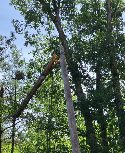
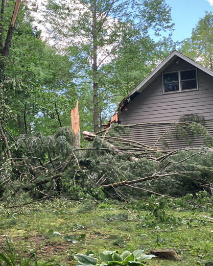
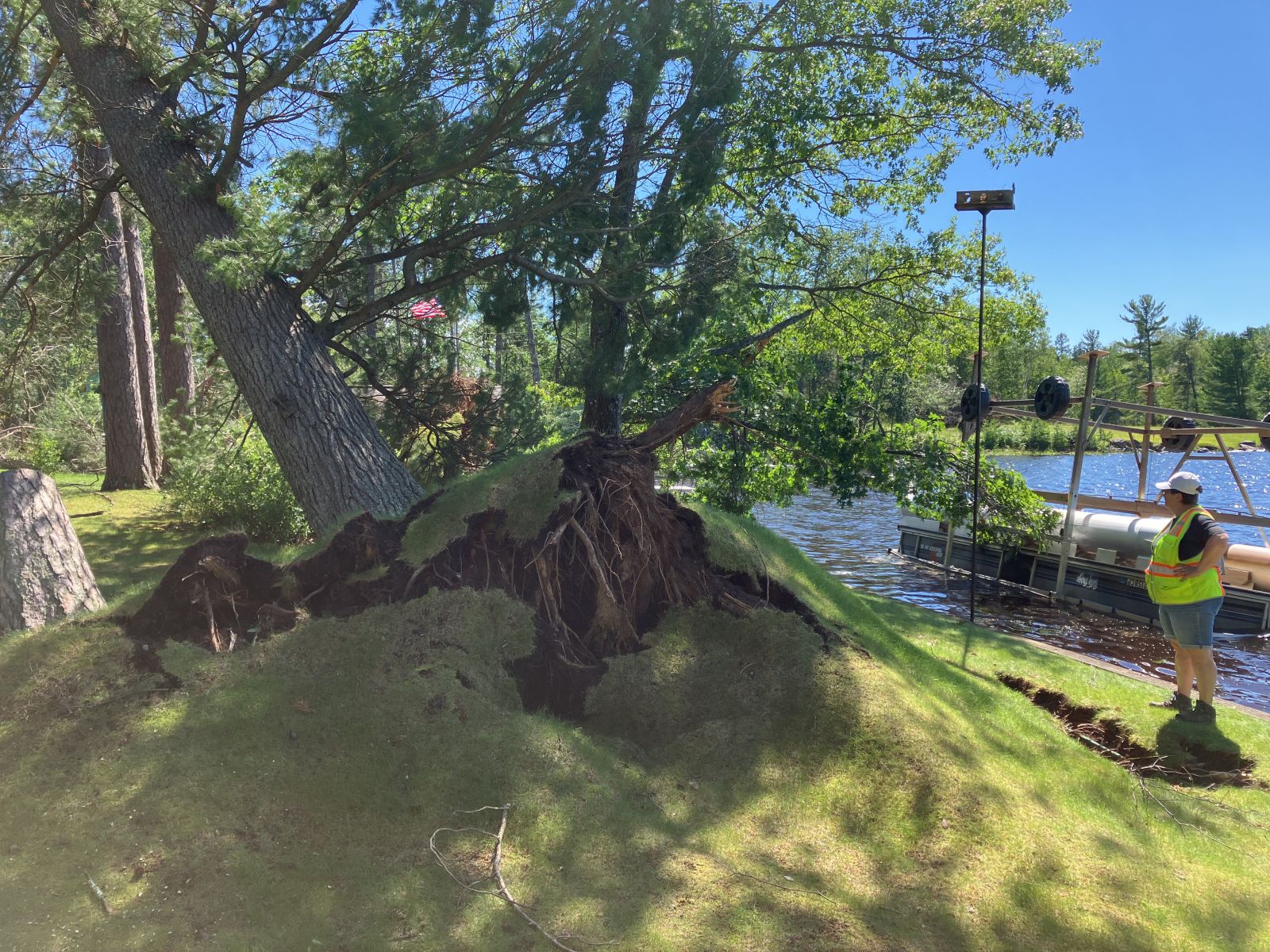 Bradley (Credit: NWS Storm Survey) |
 Bradley (Credit: NWS Storm Survey) |
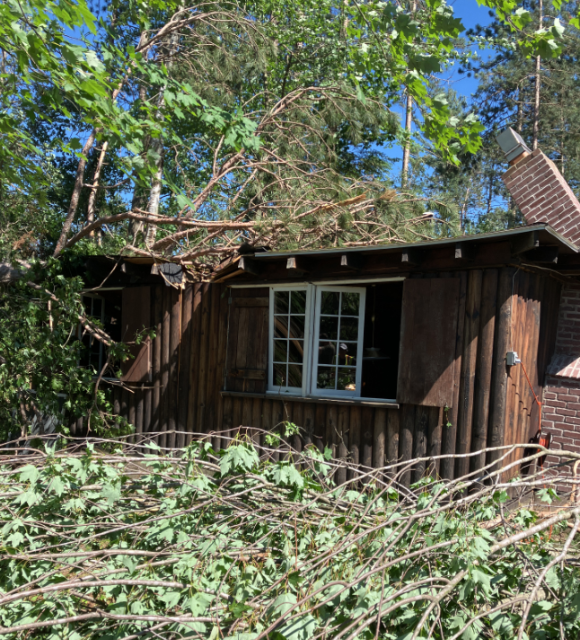 Bradley (Credit: NWS Storm Survey) |
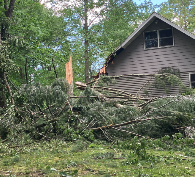 Bradley (Credit: NWS Storm Survey) |
|
|
 Keshena - Berry Lake (Credit: NWS Storm Survey) |
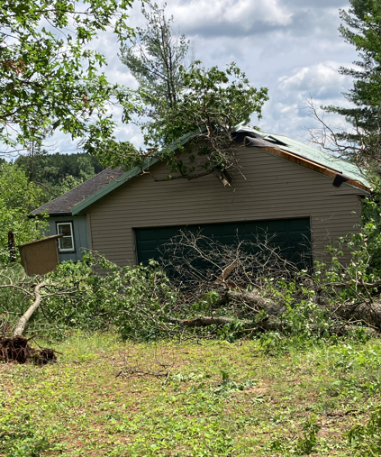 Keshena - Berry Lake (Credit: NWS Storm Survey) |
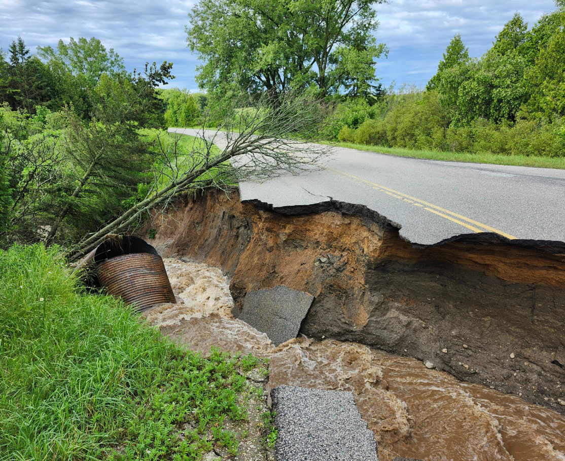 East of Forestville East of Forestville(Credit: Door Co. Emergency Management) |
 |
Media use of NWS Web News Stories is encouraged! Please acknowledge the NWS as the source of any news information accessed from this site. |
|