|
Event Overview Severe storms produced large hail and damaging straight-lines across central and east-central Wisconsin during the evening of Tuesday June 2, 2020. Hail as large as 2 inches in diameter and wind gusts of 65 to 70 were reported generally south of Highway 10 between 6 pm and 9 pm Tuesday evening (Figure 1 - see Storm/Rainfall Reports tab). The storms were also accompanied by torrential rainfall with widespread 1-2 inches of rain reported (Figure 2 - see Storm/Rainfall Reports tab), producing mostly minor flooding. Hundreds of residents also lost power due to fallen power lines and lightning strikes. The severe storm outbreak was the most significant so far this convective season in northeast Wisconsin. Environmental Overview An upper-level disturbance and associated cold front approaching from the Dakotas interacted with a hot and humid airmass situated over Wisconsin late Tuesday afternoon. The key ingredients that ultimately led to the formation of severe thunderstorms were strong upper-level winds and extreme instability. A mid-level wind maximum (green colored area in Figure 6 - see Environmental Overview tab) associated with the upper-level disturbance, created favorable vertical wind shear to support long-lived storms. Meanwhile, sunny skies allowed temperatures to soar into the 90s, with several locations breaking record highs including Green Bay, Rhinelander and Wisconsin Rapids. The hot temperatures and high moisture content allowed extreme instability to develop during the day, especially over the southern half of Wisconsin. A measure of airmass instability is called Convective Available Potential Energy (CAPE). CAPE values reached 3000 to 4000 J/kg over southern Wisconsin which caused storm updrafts to be very intense. Please see tabs below for more information. |
|
|
Storm Reports:
.jpg)
Figure 1: Storm Reports
PRELIMINARY LOCAL STORM REPORT...CORRECTED
NATIONAL WEATHER SERVICE GREEN BAY WI
1010 PM CDT TUE JUN 2 2020

..TIME...   ...EVENT...      ...CITY LOCATION...     ...LAT.LON...
..DATE...   ....MAG....      ..COUNTY LOCATION..ST.. ...SOURCE....
            ..REMARKS..

0615 PM     HAIL             BABCOCK                 44.29N 90.13W
06/02/2020  M2.00 INCH       WOOD               WI   PUBLIC

            RELAYED BY WSAW.

0615 PM     HAIL             BABCOCK                 44.29N 90.13W
06/02/2020  E1.00 INCH       WOOD               WI   TRAINED SPOTTER

0633 PM     HAIL             PORT EDWARDS            44.33N 89.84W
06/02/2020  M0.75 INCH       WOOD               WI   AMATEUR RADIO

0638 PM     TSTM WND GST     JUNCTION CITY           44.58N 89.75W
06/02/2020  E55.00 MPH       PORTAGE            WI   TRAINED SPOTTER

0640 PM     HAIL             2 S PORT EDWARDS        44.31N 89.84W
06/02/2020  M0.75 INCH       WOOD               WI   AMATEUR RADIO

            HIGHWAY 73 AND RANGELINE ROAD.

0644 PM     HAIL             1 E PLAINFIELD          44.21N 89.46W
06/02/2020  E0.88 INCH       WAUSHARA           WI   STORM CHASER

0644 PM     HAIL             JUNCTION CITY           44.58N 89.75W
06/02/2020  E0.25 INCH       PORTAGE            WI   AMATEUR RADIO

0647 PM     TSTM WND GST     3 W WISCONSIN RAPIDS    44.40N 89.90W
06/02/2020  E40.00 MPH       WOOD               WI   AMATEUR RADIO

            LEAVES BLOWING OFF BRANCHES AND SMALL BRANCHES BREAKING.

0649 PM     TSTM WND DMG     JUNCTION CITY           44.58N 89.75W
06/02/2020                   PORTAGE            WI   PUBLIC

            6 INCH DIAMETER TREE BRANCH SNAPPED AT MAIN AND NORTH
            AVENUE. REPORT VIA SOCIAL MEDIA.

0650 PM     TSTM WND GST     WISCONSIN RAPIDS        44.40N 89.84W
06/02/2020  M61.00 MPH       WOOD               WI   ASOS

0655 PM     TSTM WND GST     1 S ALMOND              44.25N 89.40W
06/02/2020  M65.00 MPH       PORTAGE            WI   STORM CHASER

            RELAYED BY WSAW.

0701 PM     TSTM WND GST     PLOVER                  44.45N 89.53W
06/02/2020  E70.00 MPH       PORTAGE            WI   CO-OP OBSERVER

            PLOW3 COOP STATION.

0703 PM     FUNNEL CLOUD     5 NW WAUTOMA            44.11N 89.35W
06/02/2020                   WAUSHARA           WI   PUBLIC

            REPORT VIA THE WAUSHARA COUNTY SHERIFF OFFICE.

0724 PM     TSTM WND GST     WAUTOMA                 44.06N 89.28W
06/02/2020  M46.00 MPH       WAUSHARA           WI   AWOS

0728 PM     HAIL             WAUTOMA                 44.06N 89.28W
06/02/2020  E1.50 INCH       WAUSHARA           WI   TRAINED SPOTTER

0732 PM     HAIL             1 SSW POY SIPPI         44.12N 89.01W
06/02/2020  M1.25 INCH       WAUSHARA           WI   STORM CHASER

0735 PM     HAIL             OSHKOSH                 44.01N 88.55W
06/02/2020  M1.00 INCH       WINNEBAGO          WI   LAW ENFORCEMENT

            NORTHSIDE OF OSHKOSH.

0735 PM     HAIL             WAUTOMA                 44.06N 89.28W
06/02/2020  M1.00 INCH       WAUSHARA           WI   TRAINED SPOTTER

            REPORTED RELAYED VIA WSAW.

0757 PM     TSTM WND GST     4 WSW WAUPACA           44.31N 89.12W
06/02/2020  E40.00 MPH       WAUPACA            WI   AMATEUR RADIO

            8-10 INCH BRANCH DOWN ON HIGHWAY K AND PAFFREYVILLE RD.

0758 PM     TSTM WND DMG     OMRO                    44.03N 88.75W
06/02/2020                   WINNEBAGO          WI   LAW ENFORCEMENT

            TREES DOWN.

0800 PM     TSTM WND GST     OSHKOSH                 44.01N 88.55W
06/02/2020  E50.00 MPH       WINNEBAGO          WI   TRAINED SPOTTER

            AT HIGHWAY 45 AND INTERSTATE 41. PONDING OF WATER ON
            INTERSTATE 41.

0804 PM     HAIL             4 N RUSH LAKE           43.97N 88.85W
06/02/2020  E0.50 INCH       WINNEBAGO          WI   LAW ENFORCEMENT

            DIME SIZE HAIL ON HIGHWAY 91 AND COUNTY E. REPORT RELAYED
            BY EM.

0808 PM     HAIL             4 N OSHKOSH             44.07N 88.54W
06/02/2020  E1.00 INCH       WINNEBAGO          WI   AMATEUR RADIO

            QUARTER SIZE HAIL AND NUMEROUS 2 TO 5 INCH BRANCHES DOWN
            FROM 804 TO 811 PM.

0808 PM     TSTM WND GST     OSHKOSH                 44.01N 88.55W
06/02/2020  M52.00 MPH       WINNEBAGO          WI   ASOS

0810 PM     TSTM WND GST     4 N RUSH LAKE           43.97N 88.83W
06/02/2020  E45.00 MPH       WINNEBAGO          WI   LAW ENFORCEMENT

            ESTIMATED WIND GUST ON HIGHWAY 91 AND COUNTY E. REPORT
            RELAYED BY EM.

0815 PM     TSTM WND DMG     OSHKOSH                 44.01N 88.55W
06/02/2020                   WINNEBAGO          WI   TRAINED SPOTTER

            8 INCH DIAMETER TREE BRANCH DOWN IN THE STREET.

0826 PM     TSTM WND GST     APPLETON                44.26N 88.40W
06/02/2020  M53.00 MPH       OUTAGAMIE          WI   TRAINED SPOTTER

0845 PM     TSTM WND DMG     CHILTON                 44.03N 88.16W
06/02/2020                   CALUMET            WI   LAW ENFORCEMENT

            TREES DOWN.SOME ON LIVE WIRES IN CHILTON.

0855 PM     TSTM WND DMG     SE CHILTON              44.03N 88.16W
06/02/2020                   CALUMET            WI   AMATEUR RADIO

            12 INCH LIVE TREE DOWN.

0919 PM     TSTM WND GST     MANITOWOC               44.08N 87.66W
06/02/2020  M45.00 MPH       MANITOWOC          WI   AWOS
Rainfall Reports
.jpg)
Figure 2: Rainfall Reports
Radar:
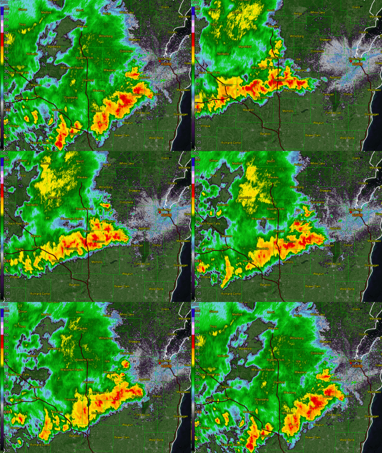
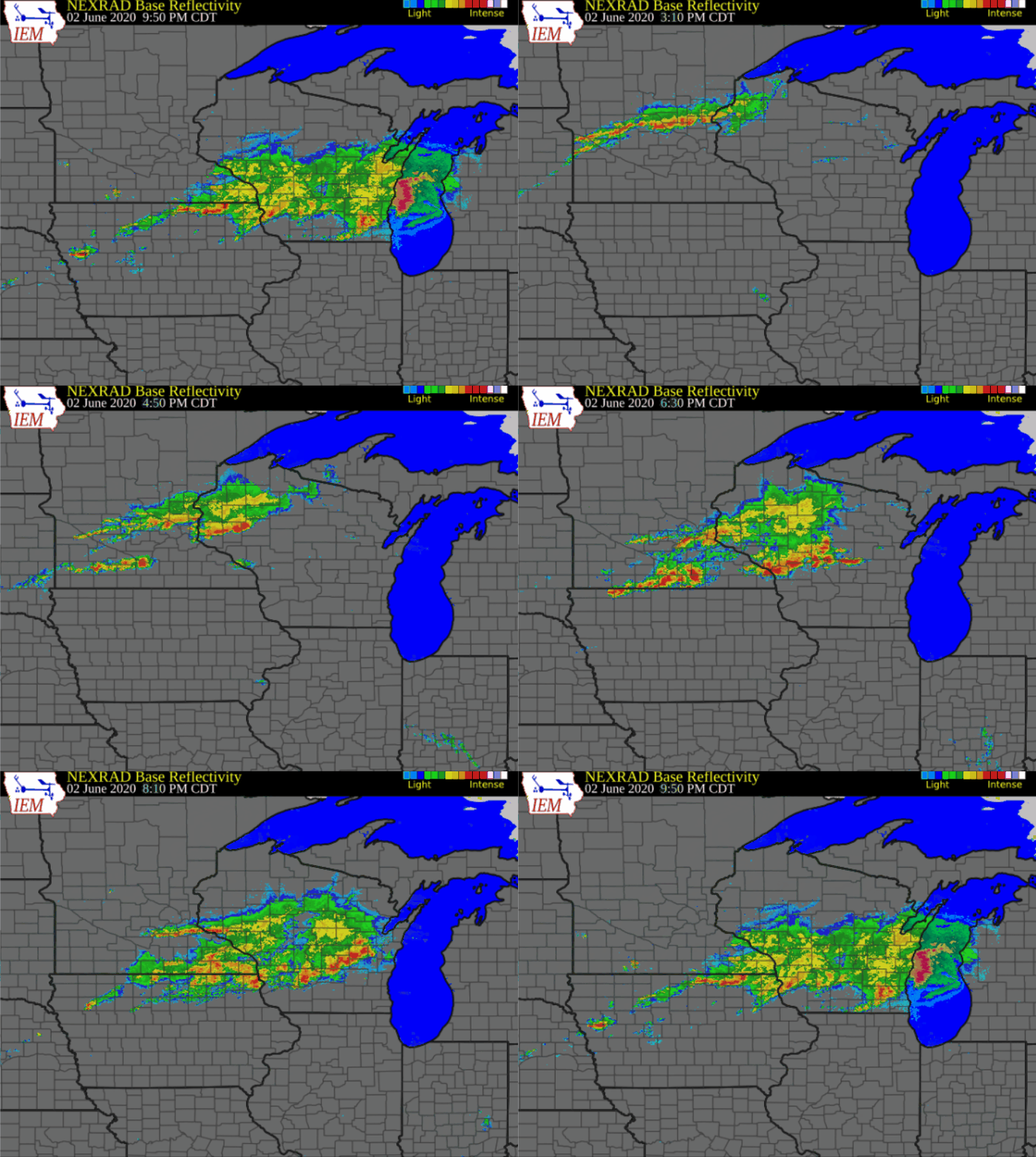
The radar evolution of the severe storm outbreak over the Upper Mississippi Valley and Western Great Lakes region is shown in Figure 4. Note the southeastward surging line of storms over central Minnesota as they merged with more discrete storms further to the south. A close-up view of the storm evolution over central and east-central Wisconsin is shown in Figure 3. Note how the discrete storms eventually congeal into approximate N-S line of storms. As this transition occurs, the threat for damaging straight line winds also increased.
Northeast Wisconsin

Figure 3: Northeast Wisconsin Radar
Regional Radar

Figure 4: Regional Radar Loop
Satellite:
|
Figure 5: Satellite Loop With Lightning Flash Detection |
Enhanced Visible Image. The enhanced visible satellite animation reveals the explosive thunderstorm development that occurred south of a cold front over far southern Minnesota into far southwest Wisconsin. Some of these initial thunderstorms produced very large hail (> 2 inches in diameter) and a few tornadoes. These storms eventually merged with other storms located further to the north, with the entire cluster of storms eventually moving into central and northeast Wisconsin after 6 pm Tuesday evening. Superimposed on the satellite imagery are visible optical lightning flashes detected from the GOES-16 satellite onboard Geostationary Lightning Mapper (GLM). As is typical with large summertime thunderstorm complexes, lightning both within the cloud, and deadly cloud-to-ground lightning strikes were prolific. |
Environmental Conditions
|
|
500mb Pattern. An upper-level disturbance and associated cold front approaching from the Dakotas interacted with a hot and humid airmass situated over Wisconsin late Tuesday afternoon. The key ingredients that ultimately led to the formation of severe thunderstorms were strong upper-level winds and extreme instability. A mid-level wind maximum (green colored area in Figure 6) associated with the upper-level disturbance, created favorable vertical wind shear to support long-lived storms. |
|
|
Convective Available Potential Energy. A measure of airmass instability is called Convective Available Potential Energy (CAPE). CAPE values reached 3000 to 4000 J/kg over southern Wisconsin which caused storm updrafts to be very intense. |
 |
Media use of NWS Web News Stories is encouraged! Please acknowledge the NWS as the source of any news information accessed from this site. |
 |