Late May 1947 Snowstorm in Wisconsin
As people were about to commemorate Decoration Day 1947 (now called Memorial Day), they were unaware that a late season snowstorm was poised to hit the central United States and western Great Lakes region. When finished, this unprecedented storm would leave up to a foot of snow in some areas causing damage to homes, trees, and other property.
The days leading up to the storm saw a noticeable drop in temperatures. On May 25, temperatures were near 70 at many locations across Wisconsin. A weak cold front pushed through Wisconsin on the 26th, bringing cooler conditions with highs around 60. A secondary and stronger cold front moved across the state on the 27th. The cold front continued south and finally stalled across the central plains into the Ohio Valley (Figure 1). Behind the cold front, cold Canadian air was firmly entrenched across Wisconsin with temperatures in the 30s and 40s.

The storm began to brew on the 27th across Colorado and was heading eastward into the central plains early on the 28th (Figure 1). A sharp contrast in temperatures was noted on the daily weather map. To the north of the front, temperatures were in the 30s and 40s with unseasonably cold dew point temperatures for late May in the teens and 20s across the northern plains. South of the front, temperatures were in the 60s and 70s with abundant moisture flowing northward into the central plains with dew point temperatures in the 50s and 60s. The ingredients were coming together for a significant spring storm across the central United States and western Great Lakes region.
As the low pressure system deepened across the central plains, the cold and dry air across the plains was driven southward. The rain changed to snow across Nebraska on the morning of the 28th and became very heavy where Alliance and Harrison received a foot of snow. The storm continued to move northeast across northern Missouri during the afternoon of the 28th. Snow was reported across the northern two thirds of Iowa with 8 inches at Cherokee, 7.5 inches at Waukton, 6 inches at Alton, and 4.5 inches at Mason City. The storm then moved northeast to near Chicago early on the 29th (Figure 2). The storm was a significant liquid precipitation producer across Wisconsin as totals (rain and melted snow combined) were generally between one and two inches across the southern half of the state. The cold air that dropped south out of Canada was the key ingredient for the rain to change to snow despite the calendar indicating it was almost June. Some locations across the plains and Wisconsin experienced their biggest May snowfalls on record.
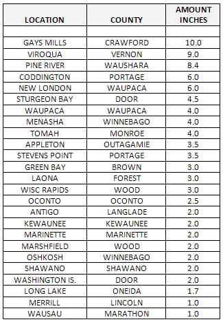
Newspaper accounts indicated that the heaviest snows fell across Wisconsin during the afternoon and evening hours on the 28th. Some snowfall totals across the state are listed in the following table.
In Wisconsin, the wet, clinging snow broke large branches off trees, damaging or killing the fruit and the trees themselves. In addition, the heavy snow knocked down power lines from the central plains into Wisconsin during the height of the storm. The spring storm also caused recurring swells on Lake Michigan of 5 feet or more along the southeast Wisconsin coastline. The high waves produced damage to small craft, docks, waterfront buildings, and property.

