Overview
|
A strong, slow-moving low pressure system drifted southeast across the upper Midwest over a 3-day period from Sunday May 17 through early Tuesday May 19. This system interacted with copious moisture streaming north from the Gulf of America that resulted in several rounds of moderate to heavy rainfall from Wisconsin, northern Illinois and Lower Michigan. Widespread rainfall amounts of 3-5 inches fell across much of east-central and northeast Wisconsin with a few locations breaking daily rainfall totals. The heavy rainfall was also accompanied by strong northeast winds gusting to 40 to 50 mph. The combination of heavy rainfall, high Lake Michigan water levels and northeast winds, led to widespread flooding and beach erosion at shoreline areas along the Bay of Green Bay and Lake Michigan. The strong northeast winds hindered the drainage of water from the Fox and East Rivers into the mouth of the bay, which contributed to flooding in parts of downtown Green Bay and further inland along the East River. Significant flooding was also observed in the city of Oconto along the Oconto River. With Lake Michigan remaining near record levels, eastern Wisconsin will continue to be vulnerable to flooding as we move into the summer months.
Preliminary 3-Day Storm Total Rainfall Please see tabs below for more information. |
|
|
Precipitation Summary:

Here is a listing of rainfall reports:
PUBLIC INFORMATION STATEMENT
NATIONAL WEATHER SERVICE GREEN BAY WI
944 AM CDT TUE MAY 19 2020

...PRECIPITATION TOTALS SINCE SATURDAY NIGHT...

LOCATION                     AMOUNT    TIME/DATE       LAT/LON
TWO RIVERS 0.9 SE            5.10 IN   0700 AM 05/19   44.15N/87.57W
MISHICOT 0.1 NNW             5.02 IN   0700 AM 05/19   44.23N/87.64W
TWO RIVERS 4.1 WNW           4.36 IN   0700 AM 05/19   44.19N/87.65W
TWO RIVERS                   4.09 IN   0700 AM 05/19   44.14N/87.57W
MANITOWOC AIRPORT            4.02 IN   0915 AM 05/19   44.12N/87.67W
GREEN BAY NWS                3.81 IN   0600 AM 05/19   44.50N/88.11W
OSHKOSH 2.0 W                3.36 IN   0700 AM 05/19   44.02N/88.59W
BRUSSELS 3 N                 3.27 IN   0700 AM 05/19   44.78N/87.62W
OCONTO AIRPORT               3.19 IN   0915 AM 05/19   44.87N/87.92W
KEWAUNEE                     3.12 IN   0700 AM 05/19   44.46N/87.50W
OSHKOSH 1.5 SSE              3.07 IN   0700 AM 05/19   44.00N/88.54W
OSHKOSH AIRPORT              3.04 IN   0853 AM 05/19   43.97N/88.55W
DENMARK WWTP                 2.86 IN   0800 AM 05/19   44.35N/87.81W
BRILLION                     2.74 IN   0658 AM 05/19   44.18N/88.07W
APPLETON 0.9 W               2.70 IN   0700 AM 05/19   44.27N/88.42W
WILD ROSE 0.5 E              2.65 IN   0700 AM 05/19   44.18N/89.24W
APPLETON                     2.52 IN   0600 AM 05/19   44.28N/88.44W
WAUTOMA 1 WSW                2.52 IN   0912 AM 05/19   44.06N/89.29W
BREED 5 NE                   2.51 IN   0903 AM 05/19   45.12N/88.37W
ALMOND 6.7 ENE               2.51 IN   0700 AM 05/19   44.29N/89.28W
OMRO 1 WSW                   2.41 IN   0700 AM 05/19   44.02N/88.78W
BONDUEL 3.3 NW               2.38 IN   0700 AM 05/19   44.78N/88.49W
WRIGHTSTOWN 0.4 ENE          2.31 IN   0700 AM 05/19   44.33N/88.17W
APPLETON                     2.30 IN   0907 AM 05/19   44.29N/88.46W
ZITTAU                       2.30 IN   0600 AM 05/19   44.22N/88.78W
KESHENA 2 WNW                2.28 IN   0905 AM 05/19   44.89N/88.66W
NEW LONDON 2 SE              2.19 IN   0630 AM 05/19   44.36N/88.72W
SHAWANO 2 SSW                2.19 IN   0800 AM 05/19   44.76N/88.62W
MENASHA 2.4 E                2.19 IN   0700 AM 05/19   44.21N/88.39W
NEENAH 1.1 ENE               2.13 IN   0700 AM 05/19   44.17N/88.45W
AMHERST 3 SE                 1.92 IN   0700 AM 05/19   44.41N/89.26W
WAUTOMA AIRPORT              1.90 IN   0856 AM 05/19   44.03N/89.30W
PULASKI 3.7 W                1.88 IN   0700 AM 05/19   44.67N/88.31W
BRILLION 2 SSE               1.86 IN   0800 AM 05/19   44.14N/88.04W
SPLIT ROCK 1 NNW             1.79 IN   0800 AM 05/19   44.72N/89.02W
SHIOCTON 0.6 NW              1.71 IN   0730 AM 05/19   44.44N/88.58W
SHAWANO AIRPORT              1.69 IN   0935 AM 05/19   44.78N/88.57W
BLACK CREEK 3 NW             1.59 IN   0700 AM 05/19   44.50N/88.47W
1.5 W MENASHA                1.53 IN   0900 AM 05/19   44.20N/88.47W
CLINTONVILLE AIRPORT         1.52 IN   0915 AM 05/19   44.62N/88.73W
WAUPACA                      1.50 IN   0935 AM 05/19   44.33N/89.02W

OBSERVATIONS ARE COLLECTED FROM A VARIETY OF SOURCES WITH VARYING
EQUIPMENT AND EXPOSURES. WE THANK ALL VOLUNTEER WEATHER OBSERVERS
FOR THEIR DEDICATION. NOT ALL DATA LISTED ARE CONSIDERED OFFICIAL.

Image – This is a forecast average accumulated precipitation over the Great Lakes over a 48 hour period ending on Monday evening May 19. Note the area of 4-6 inches over east-central Wisconsin and another area over lower Michigan. Lower Michigan received even more rainfall than northeast Wisconsin, which led to two dam failures near the city of Midland, MI that resulted in historic and catastrophic flooding late Tuesday May 19 and Wednesday May 20.
Wind Reports:

Surface Pattern/Radar/Satellite:
.gif) |
Image - Surface Pressure Animation. Associated with the upper-level circulation, a slow-moving surface low meandered over eastern Iowa and northern Illinois before finally drifting southeast and weakening. Note that there was also a strengthening area of high pressure (brown shaded area) that was parked just north of Wisconsin. The combination of these pressure systems created very strong and persistent northeast winds across much of Wisconsin on Sunday May 17th and Monday May 18th. The strong winds caused water levels to rise significantly along lake shore areas. |
.gif) |
Image – Radar Composite Animation. An extensive area of moderate to heavy precipitation surged northward into the upper-Midwest and Great Lakes region. Note the precipitation echoes being wrapped back toward the west into east-central Wisconsin. This extended the duration of heavy rainfall over Lower Michigan and eastern Wisconsin, leading to significant 2-3 day rainfall totals and flooding.
|
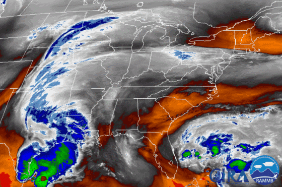 |
Image - GOES-16 water vapor satellite image animation. This animation shows a strong and slow moving upper-level circulation heading southeast across the upper Midwest from May 17th through May 19th. The upper-level system passed to the south of Wisconsin. |
Flooding
Reports of flooding across Green Bay:

 |
Downtown Green Bay |
 |
Downtown Green Bay - South Broadway |
 |
Green Bay Boat Landing and Coast Guard Station |
 |
East River Green Bay |
 |
East River Green Bay |
 |
East River Green Bay |
 |
Oconto, WI |
 |
Menominee, MI |
 |
Media use of NWS Web News Stories is encouraged! Please acknowledge the NWS as the source of any news information accessed from this site. |
|


