March 4-5, 2025 -- Rain, Snow & Wind Event Summary
|
Event Overview Deep low pressure originating over the southwestern United States - sometimes termed as a “Colorado Low” - lifted into the western Great Lakes by daybreak Wednesday, March 5. The low resulted in a multi-faceted hazardous weather event across central and northeast Wisconsin including heavy rain, strong winds, and heavy snow beginning on the afternoon of Tuesday (March 4) and continuing through the early evening of Wednesday, March 5. Highlights from this storm included almost 2 inches of total liquid precipitation over northern portions of Door County, around a foot of snow leading to snow covered roads and difficult travel over north-central Wisconsin from Vilas to Florence counties, and gusty winds reaching as high as 54 mph at Wausau. To start off, a swath of moderate to heavy rain arrived from the south early Tuesday evening and spread across the entire area. A few lightning strikes also accompanied the rain in the Wausau area. As cold air worked in from the north, the rain quickly changed to snow as early as 9 pm at Rhinelander. Heavy snow fell the rest of the evening with snowfall rates of 1”/hr observed through midnight. In areas further south and east where precipitation didn't change over to snow, the rain became heavy at times overnight, pushing many rivers in the area above bankfull. Some additional minor flooding and ponding was also reported in low-lying and poor drainage areas. The rain finally fully switched over to snow over portions of central Wisconsin shortly before daybreak early Wednesday morning. As the low shifted over central Lake Michigan through the latter part of Wednesday morning, the remaining areas of rain changed over to rain across the rest of central and northeast Wisconsin. Despite the switch to snow relatively early in the day, little to no accumulation was observed across east-central Wisconsin due to the relatively warm ground temperatures across eas- However, warmer ground temperatures still present. Accumulations didn't really start in these areas until around midday when ground temperatures finally dropped below freezing, but were limited mainly to grassy areas and untreated roads. Northerly winds were on the increase during this time, with gusts increasing up to over 40 mph from west to east through the early afternoon. The combination of wind and snow led to considerable blowing and drifting snow and poor visibility down to 1/4 to 1/2 mile at times. The worst of the snow, blowing snow, and poor visibility for the Fox Valley and east-central Wisconsin occurred late Wednesday afternoon, resulting in a slower than normal evening commute. As the low tracked into northern lower Michigan Wednesday afternoon, snow began to diminish over north-central and central Wisconsin. The gusty winds did lead to lingering blowing snow in open areas. The last of the snow ended by mid-evening over northeast and east-central Wisconsin. Temperatures falling into the teens and 20s Wednesday evening caused any lingering moisture from the earlier rain and snow to freeze on roads and surfaces, resulting in icy conditions on untreated roads for the next morning. The highest snowfall totals were observed across northern Wisconsin, with widespread amounts of 8 to 12 inches. The rest of the area saw lesser snow amounts, generally from 1 to 5 inches, due to a slower than expected change from rain to snow and the warmer ground temperatures at the start of the change over to snow. All areas saw moderate to heavy precipitation totals (rain and melted snow combined) of 0.75 to 1.50 inches, and isolated amounts from 1.50 inches to nearly 2 inches. The gusty winds affected most of the area as well, reducing visibility due to the falling snow and causing tree limbs to break under the weight of the wet, sticky snow, which led to sporadic power outages. Please see tabs below for more information. |
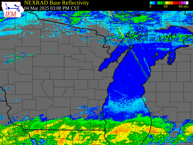
Radar Loop from 3pm Tue, March 4, 2025 - 11pm Wed, March 5, 2025
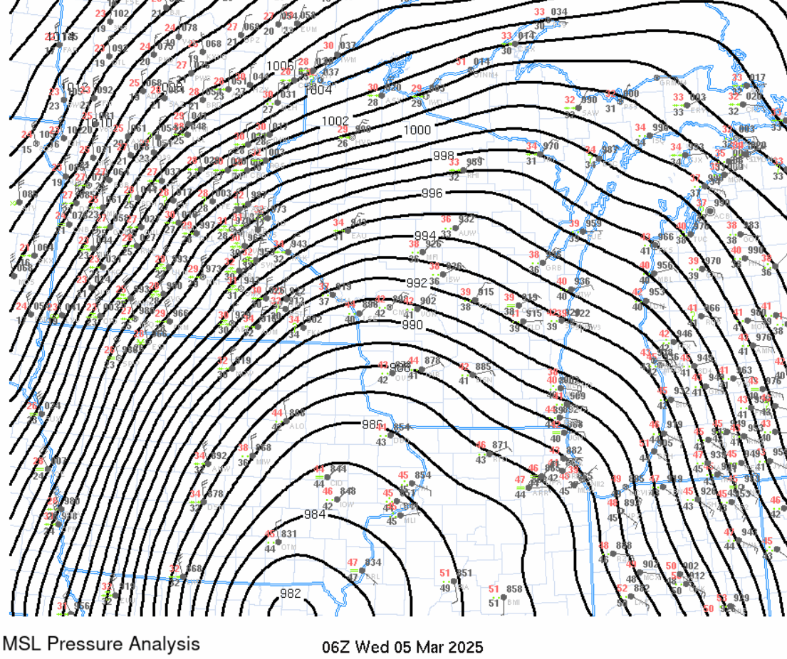
Mean Sea Level Pressure Analysis with station plots showing the track of the surface low pressure system from 12am-11pm Wed, March 5, 2025. |
Snow Reports
Map shows estimated observed snowfall over a 48-hour period ending
at 6 AM CST 3/6/25.

...PRELIMINARY 48-HOUR SNOWFALL REPORTS...

Location                     Amount    Time/Date       Provider

...Wisconsin...

...Brown County...
Green Bay 3.8 SSE            2.0 in    0700 AM 03/06   COCORAHS
Howard 1.7 SSW               1.6 in    0700 AM 03/06   COCORAHS
3 NW Ashwaubenon             1.5 in    0600 AM 03/06   Official NWS Obs
Wrightstown 0.4 ENE          0.5 in    0700 AM 03/06   COCORAHS
Denmark WWTP                 0.4 in    0800 AM 03/06   COOP

...Calumet County...
Brillion                     1.0 in    0630 AM 03/06   COOP

...Door County...
Forestville 4 E              1.2 in    0700 AM 03/06   UCOOP
Sturgeon Bay Exp Farm        1.0 in    0730 AM 03/06   COOP
Egg Harbor 2.4 ENE           1.0 in    0700 AM 03/06   COCORAHS

...Florence County...
Spread Eagle 1 NW            13.0 in   0700 AM 03/06   COCORAHS
Florence                     10.3 in   0700 AM 03/06   COOP
Aurora 0.7 E                 10.0 in   0530 AM 03/06   COCORAHS

...Forest County...
Argonne 1.5 NW               9.9 in    0745 AM 03/06   COOP

...Kewaunee County...
Kewaunee                     0.7 in    0615 AM 03/06   COOP

...Langlade County...
White Lake 1.4 SE            3.5 in    0800 AM 03/06   COOP

...Lincoln County...
Tomahawk 1.2 SSW             6.2 in    0700 AM 03/06   COCORAHS
Merrill 8 W                  5.1 in    0600 AM 03/06   UCOOP

...Manitowoc County...
Two Rivers                   1.5 in    0700 AM 03/06   COOP
St. Nazianz 2 W              0.9 in    0700 AM 03/06   UCOOP
Millhome 2 E                 0.2 in    0713 AM 03/06   COCORAHS

...Marathon County...
Wausau 2.4 W                 3.8 in    0800 AM 03/06   COCORAHS
Wausau 1.6 ENE               3.5 in    0600 AM 03/06   COCORAHS
Weston 1 NE                  2.9 in    0700 AM 03/06   COCORAHS
Wausau WSAW TV               2.8 in    1100 PM 03/05   COOP
Dancy 1 NNW                  2.3 in    0700 AM 03/06   COCORAHS
Spencer - Wwtp               0.5 in    0730 AM 03/06   UCOOP
Stratford 1 NW               0.3 in    0615 AM 03/06   COOP

...Marinette County...
Athelstane 1.6 E             3.4 in    0600 AM 03/06   UCOOP
Peshtigo 1 S                 2.0 in    0730 AM 03/06   COOP
Amberg 9 E                   1.7 in    0646 AM 03/06   UCOOP
Marinette - Wps              1.3 in    0637 AM 03/06   UCOOP
Wausaukee 1.6 NW             1.0 in    0749 AM 03/06   COOP

...Oconto County...
Mountain 0.9 E               3.3 in    0700 AM 03/06   COCORAHS
Oconto Falls 1.0 SE          2.9 in    0630 AM 03/06   COCORAHS
2 E Sampson                  2.5 in    0641 AM 03/06   Trained Spotter
Shawano Lake 6 NNE           1.5 in    0800 AM 03/06   COCORAHS

...Oneida County...
2 W Pelican Lake             10.5 in   1000 PM 03/05   Public
Rhinelander 5.5 NW           10.1 in   0600 AM 03/06   COCORAHS
4 ESE Mc Naughton            10.1 in   0424 PM 03/05   Public
3 W Goodnow                  10.0 in   0234 PM 03/05   Public
Rhinelander                  9.9 in    0914 PM 03/05   Broadcast Media
Rhinelander 2 SW             8.0 in    0730 AM 03/06   COOP
Hazelhurst 2.1 SSE           8.0 in    0700 AM 03/05   COCORAHS
Minocqua                     6.0 in    0630 AM 03/06   COOP

...Outagamie County...
Shiocton 0.6 NW              5.0 in    0730 AM 03/06   COOP
Appleton                     1.4 in    0500 AM 03/06   COOP

...Portage County...
Almond 5 NE                  3.4 in    0800 AM 03/06   UCOOP
Amherst 3 SE                 3.4 in    0700 AM 03/06   UCOOP
5 SW Amherst                 3.1 in    0400 PM 03/05   Trained Spotter
Wisconsin Rapids 9.8 SE      3.0 in    0700 AM 03/06   COCORAHS
Stevens Point                2.7 in    0712 AM 03/06   COOP
Plover 1.4 S                 2.1 in    0700 AM 03/06   COCORAHS
Rudolph 1 NNE                1.5 in    0500 AM 03/06   COCORAHS

...Shawano County...
Pella 3 SE                   5.0 in    0530 AM 03/06   UCOOP
Shawano 2 SSW                5.0 in    0800 AM 03/06   COOP

...Vilas County...
Phelps 4.2 N                 11.0 in   0733 AM 03/06   COOP
Conover 4.8 WNW              8.5 in    0700 AM 03/06   COCORAHS
St Germain 0.6 NW            7.7 in    0700 AM 03/06   COOP
Woodruff 2.5 NE              7.2 in    0700 AM 03/06   COCORAHS
Boulder Junction 9 ENE       7.0 in    0700 AM 03/06   COCORAHS
Boulder Junction 1.4 NE      6.7 in    0700 AM 03/06   COCORAHS
Arbor Vitae-Johnson Lake     5.0 in    0600 AM 03/06   UCOOP

...Waupaca County...
Clintonville                 4.5 in    0700 PM 03/05   Trained Spotter
Waupaca 1.4 W                4.5 in    0600 AM 03/06   COCORAHS
Ogdensburg 2 E               3.0 in    0700 AM 03/06   COCORAHS
New London - WWTP            2.0 in    0700 AM 03/06   UCOOP

...Waushara County...
Wild Rose 0.5 E              2.8 in    0500 AM 03/06   COCORAHS
Plainfield                   2.5 in    0900 PM 03/05   Public

...Winnebago County...
Neenah 1.1 ENE               2.1 in    0700 AM 03/06   COCORAHS
Oshkosh                      2.0 in    0700 AM 03/06   COOP

...Wood County...
Hewitt 0.8 N                 2.4 in    0730 AM 03/06   COOP
Port Edwards 2 E             2.3 in    0730 AM 03/06   COCORAHS
Marshfield 6.5 S             2.3 in    0800 AM 03/06   COCORAHS
Pittsville - WWTP            2.0 in    0700 AM 03/06   UCOOP


Observations are collected from a variety of sources with varying
equipment and exposures. We thank all volunteer weather observers
for their dedication. Not all data listed are considered official.
Rainfall Reports
Map shows estimated observed precipitation (rainfall and melted down snow)
over a 48-hour period ending at 2 PM CST 3/6/25.

...PRELIMINARY 48-HOUR PRECIPITATION REPORTS...

Location                     Amount    Time/Date       Provider

...Wisconsin...

...Brown County...
Howard 1.7 SSW               1.47 in   0700 AM 03/06   COCORAHS
Green Bay 3.8 SSE            1.42 in   0700 AM 03/06   COCORAHS
3 NW Ashwaubenon             1.36 in   1200 AM 03/06   Official NWS Obs
Wrightstown 0.4 ENE          1.36 in   0700 AM 03/06   COCORAHS
Denmark WWTP                 1.34 in   0800 AM 03/06   COOP

...Calumet County...
Chilton 0.5 E                1.36 in   0700 AM 03/06   COOP
Brillion 4.9 S               1.31 in   0700 AM 03/06   COCORAHS
Brillion                     1.22 in   0630 AM 03/06   COOP

...Door County...
Sister Bay 1 N               1.91 in   0700 AM 03/06   COCORAHS
Ellison Bay 0.0 SE           1.88 in   0800 AM 03/06   COCORAHS
Egg Harbor 2.4 ENE           1.85 in   0700 AM 03/06   COCORAHS
Sturgeon Bay Exp Farm        1.72 in   0730 AM 03/06   COOP
Fish Creek 1 E WWTP          1.48 in   0836 AM 03/06   UCOOP
Forestville 4 E              1.29 in   0700 AM 03/06   UCOOP

...Florence County...
Florence                     1.12 in   0700 AM 03/06   COOP

...Forest County...
Argonne 1.5 NW               1.33 in   0745 AM 03/06   COOP

...Kewaunee County...
Luxemburg 0.9 S              1.36 in   0722 AM 03/06   COCORAHS
Casco 0.4 NNW                1.23 in   0610 AM 03/06   COCORAHS

...Langlade County...
White Lake 1.4 SE            1.15 in   0800 AM 03/06   COOP

...Lincoln County...
Merrill 8 W                  1.35 in   0600 AM 03/06   UCOOP
Tomahawk 1.2 SSW             0.98 in   0700 AM 03/06   COCORAHS

...Manitowoc County...
Two Rivers 1.2 N             1.57 in   0700 AM 03/06   COCORAHS
Manitowoc 0.6 NE             1.52 in   0600 PM 03/05   COOP
Two Rivers                   1.49 in   0700 AM 03/06   COOP
Mishicot 0.1 NNW             1.44 in   0800 AM 03/06   COCORAHS
Two Rivers 4.1 WNW           1.40 in   0700 AM 03/06   COCORAHS
St. Nazianz 2 W              1.32 in   0700 AM 03/06   UCOOP
Manitowoc 5.1 SW             1.30 in   0800 AM 03/06   COCORAHS
Millhome 2 E                 1.26 in   0713 AM 03/06   COCORAHS

...Marathon County...
Rothschild 0.5 ENE           1.55 in   0700 AM 03/06   COCORAHS
Wausau 1.6 ENE               1.54 in   0600 AM 03/06   COCORAHS
Wausau 2.4 W                 1.44 in   0800 AM 03/06   COCORAHS
Weston 1 NE                  1.43 in   0700 AM 03/06   COCORAHS
Dancy 1 NNW                  1.24 in   0700 AM 03/06   COCORAHS
Spencer - Wwtp               0.77 in   0730 AM 03/06   UCOOP

...Marinette County...
Amberg 9 E                   1.28 in   0646 AM 03/06   UCOOP
Athelstane 1.6 E             1.24 in   0600 AM 03/06   UCOOP

...Oconto County...
Mountain 0.9 E               1.29 in   0700 AM 03/06   COCORAHS
Oconto Falls 1.0 SE          1.27 in   0630 AM 03/06   COCORAHS

...Oneida County...
Rhinelander 5.5 NW           1.45 in   0600 AM 03/06   COCORAHS
Rhinelander 2 SW             1.13 in   0730 AM 03/06   COOP
Minocqua                     1.10 in   0630 AM 03/06   COOP

...Outagamie County...
Appleton 3.0 ESE             1.37 in   0620 AM 03/06   COCORAHS
Shiocton 0.6 NW              1.36 in   0730 AM 03/06   COOP
Appleton                     1.32 in   0500 AM 03/06   COOP

...Portage County...
Amherst 3 SE                 1.36 in   0700 AM 03/06   UCOOP
Wisconsin Rapids 6.6 ESE     1.24 in   0700 AM 03/06   COCORAHS
Plover 1.4 S                 1.18 in   0700 AM 03/06   COCORAHS
Stevens Point                1.17 in   0712 AM 03/06   COOP
Almond 5 NE                  1.14 in   0800 AM 03/06   UCOOP
Rudolph 1 NNE                0.82 in   0500 AM 03/06   COCORAHS

...Shawano County...
Shawano 2 SSW                1.39 in   0800 AM 03/06   COOP
Pella 3 SE                   1.17 in   0530 AM 03/06   UCOOP

...Vilas County...
Woodruff 2.5 NE              1.00 in   0700 AM 03/06   COCORAHS
Phelps 4.2 N                 0.94 in   0733 AM 03/06   COOP
Conover 4.8 WNW              0.92 in   0700 AM 03/06   COCORAHS
St Germain 0.6 NW            0.91 in   0700 AM 03/06   COOP
Boulder Junction 9 ENE       0.88 in   0700 AM 03/06   COCORAHS

...Waupaca County...
New London - WWTP            1.34 in   0700 AM 03/06   UCOOP
Waupaca 7.6 SW               1.20 in   0700 AM 03/06   COCORAHS
Waupaca 1.4 W                1.00 in   0600 AM 03/06   COCORAHS

...Waushara County...
Wild Rose 0.5 E              1.42 in   0500 AM 03/06   COCORAHS

...Winnebago County...
Neenah 1.1 ENE               1.41 in   0700 AM 03/06   COCORAHS
Menasha 0.3 W                1.36 in   0700 AM 03/06   COCORAHS
Oshkosh 1.5 SSE              1.34 in   0700 AM 03/06   COCORAHS
Oshkosh                      1.22 in   0700 AM 03/06   COOP

...Wood County...
New Rome 3 WNW               1.23 in   0700 AM 03/06   COCORAHS
Port Edwards 2 E             1.13 in   0730 AM 03/06   COCORAHS
Rudolph 2.1 W                1.04 in   0700 AM 03/06   COCORAHS
Marshfield 5.6 SSW           1.02 in   0700 AM 03/06   COCORAHS
Pittsville - WWTP            0.93 in   0700 AM 03/06   UCOOP
Hewitt 0.8 N                 0.85 in   0730 AM 03/06   COOP

Observations are collected from a variety of sources with varying
equipment and exposures. We thank all volunteer weather observers
for their dedication. Not all data listed are considered official.
Peak Wind Reports:
...PRELIMINARY PEAK WIND GUST REPORTS...

Location                     Amount    Time/Date       Provider

...Wisconsin...

...Brown County...
De Pere                      46 MPH    0500 PM 03/05   MESOWEST
Green Bay Airport            46 MPH    0253 PM 03/05   ASOS
Green Bay - Leo Frigo Bridge 41 MPH    0547 PM 03/05   MESOWEST
De Pere                      39 MPH    0540 PM 03/05   CWOP
Wrightstown                  35 MPH    0525 PM 03/05   CWOP

...Calumet County...
Brillion                     39 MPH    0445 PM 03/05   MESOWEST

...Door County...
Sturgeon Bay Airport         48 MPH    0608 PM 03/05   AWOS
Washington Island Airport    47 MPH    0635 PM 03/05   AWOS
Chambers Island 1 NNW        46 MPH    0440 PM 03/05   NDBC
Sturgeon Bay Airport         45 MPH    0514 PM 03/05   AWOS
Ephraim Airport              41 MPH    0535 PM 03/05   AWOS
Egg Harbor 3.1 SE (MAWN)     36 MPH    0420 PM 03/05   MESOWEST

...Florence County...
Sth 70 At Sth 139            47 MPH    0137 PM 03/05   MESOWEST

...Kewaunee County...
Kewaunee MET, WI             49 MPH    0212 PM 03/05   NOS-NWLON
Kewaunee                     37 MPH    0535 PM 03/05   MESOWEST

...Langlade County...
Antigo Airport               49 MPH    0255 PM 03/05   AWOS
Antigo 2 ENE                 43 MPH    0305 PM 03/05   RAWS
Antigo                       37 MPH    0430 PM 03/05   MESOWEST

...Lincoln County...
Merrill Airport              37 MPH    0415 PM 03/05   AWOS

...Manitowoc County...
Manitowoc Airport            46 MPH    0630 PM 03/05   AWOS
Valders                      41 MPH    0530 PM 03/05   MESOWEST
Reedsville                   38 MPH    0600 PM 03/05   CWOP
Valders                      36 MPH    0510 PM 03/05   MESOWEST
MANITOWOC                    36 MPH    0455 PM 03/05   CWOP

...Marathon County...
Wausau Airport               54 MPH    0257 PM 03/05   ASOS
Marshfield                   41 MPH    0115 PM 03/05   MESOWEST
Mosinee Airport              39 MPH    0450 PM 03/05   AWOS

...Marinette County...
Menominee                    41 MPH    0500 AM 03/05   NOS-NWLON

...Oconto County...
Breed 5 NE                   43 MPH    0530 PM 03/05   RAWS
Suring                       39 MPH    0340 PM 03/05   MESOWEST

...Oneida County...
Rhinelander Airport          36 MPH    0649 PM 03/05   ASOS

...Vilas County...
Arbor Vitae Airport          43 MPH    0135 PM 03/05   AWOS
Eagle River Airport          37 MPH    0415 PM 03/05   AWOS
Manitowish Waters Airport    36 MPH    0355 PM 03/05   AWOS
Land O Lakes Airport         36 MPH    0315 PM 03/05   AWOS

...Waupaca County...
Clintonville Airport         37 MPH    0415 PM 03/05   AWOS
Waupaca Airport              35 MPH    0535 PM 03/05   AWOS

...Winnebago County...
Oshkosh Airport              44 MPH    0436 PM 03/05   ASOS
Oshkosh                      38 MPH    0645 PM 03/05   CWOP

...Wood County...
Marshfield Airport           51 MPH    0503 PM 03/05   AWOS

...Maritime Stations...
Gills Rock 1 ENE             51 MPH    0400 PM 03/05   NDBC

Observations are collected from a variety of sources with varying
equipment and exposures. We thank all volunteer weather observers
for their dedication. Not all data listed are considered official.
 |
Media use of NWS Web News Stories is encouraged! Please acknowledge the NWS as the source of any news information accessed from this site. |
|