February 14-16, 2025 Snow Event Summary
|
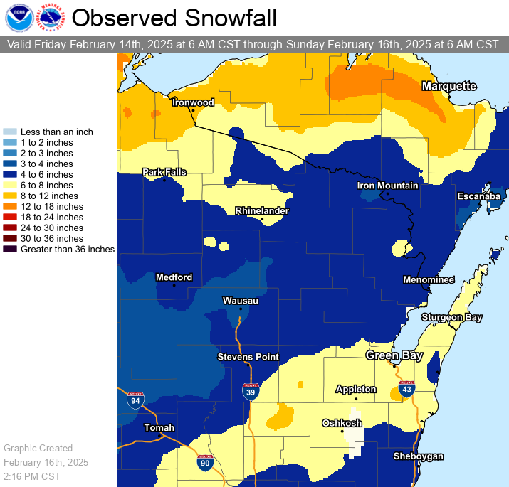
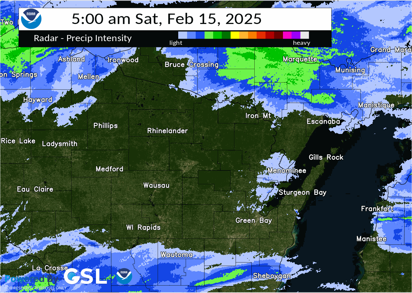
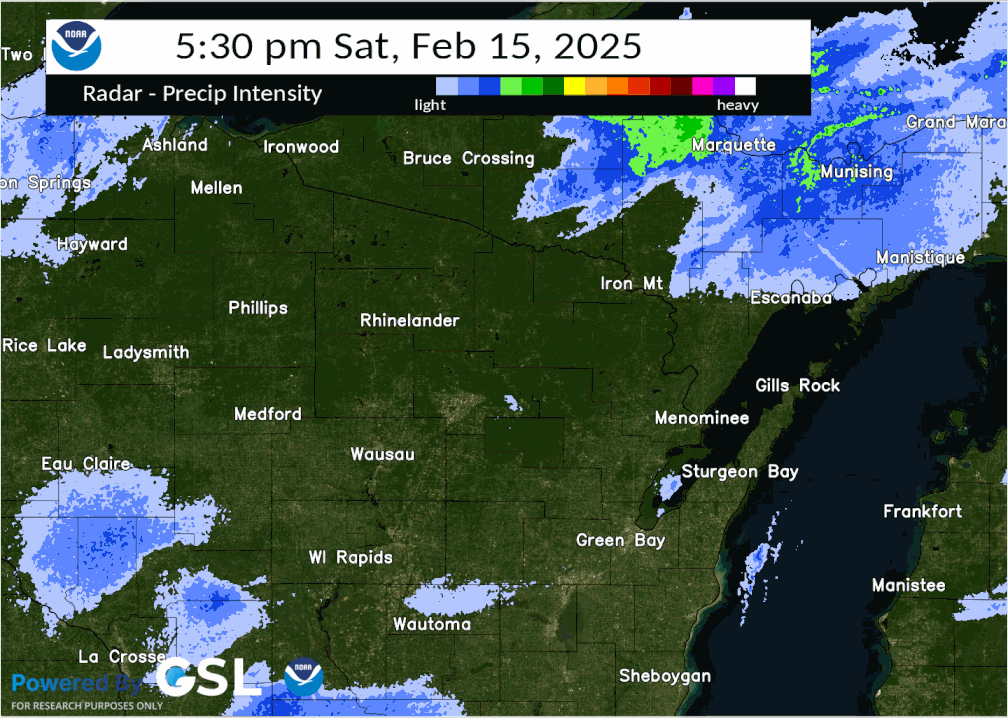
Event Overview A complex winter storm brought three rounds of snow from late Friday afternoon through Sunday morning. The highest snowfall totals of 6 to 10 inches were from portions of central into east-central Wisconsin. The first round of snow moved into north-central and central Wisconsin late Friday afternoon, in response to strong warm advection and an upper level disturbance moving across the region. The snow then spread eastward across the entire area Friday evening and continued into early Saturday morning. The first wave of steadier snow exited the area around day break. Meanwhile, a southwest to northeast band of snow developed across central into northeast Wisconsin by mid-morning on Saturday. This band of snow was associated with snowfall rates around an inch per hour and dropped visibilities down to around a half mile at times. The snow band dissipated late Saturday afternoon. The lull in the snow across northeast Wisconsin was brief! The third wave of snow was associated with an upper level disturbance moving across the region along with lake effect snow showers. Low pressure passing well south of the area resulted in winds turning northeast off the relatively warmer waters of Lake Superior and Lake Michigan. Locally higher snowfall rates and totals were reported near the Lake Michigan shoreline. Appleton, Green Bay, Oshkosh, and Steven Point set a new daily snowfall record on the 15th. The snow tapered off Sunday morning as winds backed to the northwest. The gusty northwest winds on Sunday resulted in areas of blowing and drifting snow, especially in open areas. The blowing and drifting snow likely impacted sturgeon spearing on Lake Winnebago and ice fishing on the Bay of Green Bay.
Please see tabs below for more information. |
|
Snow Reports
...PRELIMINARY SNOWFALL REPORTS...

Location                     Amount    Time/Date       Provider

...Wisconsin...

...Brown County...
2 WNW Ashwaubenon            7.2 in    1200 PM 02/16   Official NWS Obs
3 SE De Pere                 6.4 in    0630 AM 02/16   Public
Howard 1.7 SSW               6.3 in    0700 AM 02/16   COCORAHS
Green Bay 3.8 SSE            6.3 in    0700 AM 02/16   COCORAHS
2 WNW Howard                 6.1 in    0236 PM 02/15
Wrightstown 0.4 ENE          5.5 in    0700 AM 02/16   COCORAHS

...Calumet County...
High Cliff State Park        6.4 in    0530 PM 02/15   Public
Brillion WWTP                5.5 in    0945 AM 02/16   COOP

...Door County...
Fish Creek 1 E WWTP          7.3 in    0740 AM 02/16   UCOOP
Washington Island            6.7 in    0700 AM 02/16   COOP
Forestville 4 E              6.5 in    0700 AM 02/16   UCOOP
Sturgeon Bay                 6.2 in    0820 PM 02/15   Trained Spotter
Egg Harbor 2.4 ENE           6.1 in    0700 AM 02/16   COCORAHS
Sister Bay 1 N               6.0 in    0700 AM 02/16   COCORAHS

...Forest County...
Argonne 1.5 NW               4.9 in    0744 AM 02/16   COOP

...Kewaunee County...
Kewaunee                     4.1 in    0700 AM 02/16   COOP

...Langlade County...
White Lake 1.4 SE            4.0 in    0700 AM 02/16   COOP
Summit Lake                  3.9 in    0500 AM 02/16   COOP

...Lincoln County...
Tomahawk 1.2 SSW             6.6 in    0700 AM 02/16   COCORAHS
Bradley 1.0 NE               4.6 in    0700 AM 02/16   COOP
Merrill 8 W                  3.2 in    0600 AM 02/16   UCOOP

...Manitowoc County...
Two Rivers                   8.3 in    0928 AM 02/16   Public
Two Rivers 2 NW              7.0 in    0700 AM 02/16   COCORAHS
Two Rivers 1.2 N             7.0 in    0700 AM 02/16   COCORAHS
Two Rivers                   6.4 in    0700 AM 02/16   COOP
Mishicot 0.1 NNW             5.0 in    0800 AM 02/16   COCORAHS

...Marathon County...
Moon 1 E                     5.0 in    0500 AM 02/16   COOP
Wausau 1.6 ENE               4.2 in    0600 AM 02/16   COCORAHS
Stratford 1 NW               3.5 in    0618 AM 02/16   COOP

...Marinette County...
Amberg 9 E                   7.6 in    0701 AM 02/16   UCOOP
Athelstane 6 SW              6.0 in    0700 AM 02/16   COOP
Athelstane 1.6 E             5.4 in    0600 AM 02/16   UCOOP
Menominee 1.6 S              5.0 in    0730 AM 02/16   COOP
Peshtigo 1 S                 4.9 in    0730 AM 02/16   COOP

...Oconto County...
Pulaski - WWTP               6.7 in    0600 AM 02/16   COOP
Oconto 4 W                   5.4 in    0700 AM 02/16   COOP
Suring                       5.3 in    0825 AM 02/16   COOP
Mountain 0.9 E               4.5 in    0700 AM 02/16   COCORAHS
Shawano Lake 6 NNE           4.3 in    0800 AM 02/16   COCORAHS

...Oneida County...
Rhinelander 5 N              7.1 in    0800 AM 02/16   COCORAHS
Minocqua                     7.0 in    0630 AM 02/16   COOP
Rhinelander 4 NE             6.6 in    0600 AM 02/16   COOP
Rhinelander WJFW-TV          5.7 in    1010 PM 02/15   COOP
Rhinelander 2 SW             5.0 in    0730 AM 02/16   COOP
Willow                       4.3 in    0700 AM 02/16   COOP

...Outagamie County...
Kaukauna 1 W                 8.1 in    0415 AM 02/16   COCORAHS
2 NNW Appleton               8.0 in    0732 AM 02/16   Public
Greenville                   7.5 in    0441 PM 02/15
Kimberly                     7.5 in    0500 PM 02/15   Public
Appleton                     7.2 in    0500 AM 02/16   COOP
Appleton 3.0 ESE             7.1 in    0825 AM 02/16   COCORAHS
Shiocton 0.6 NW              6.9 in    0730 AM 02/16   COOP
New London 2 SE              6.7 in    0630 AM 02/16   COOP

...Portage County...
Amherst 2.6 SSE              6.5 in    0700 AM 02/16   COCORAHS
Amherst 3 SE                 6.5 in    0700 AM 02/16   UCOOP
5 SSW Amherst                6.0 in    0415 PM 02/15   Trained Spotter
Rosholt                      5.3 in    0750 AM 02/16   COOP
Plover 1.4 S                 5.1 in    0700 AM 02/16   COCORAHS
Stevens Point                4.5 in    0530 AM 02/16   COOP
Rudolph 1 NNE                4.0 in    0500 AM 02/16   COCORAHS

...Shawano County...
Shawano 2 SSW                5.5 in    0800 AM 02/16   COOP

...Vilas County...
Manitowish Waters 0.6 S      7.0 in    0830 AM 02/16   COOP
Boulder Junction 9 ENE       6.9 in    0700 AM 02/16   COCORAHS
St Germain 0.6 NW            6.2 in    0700 AM 02/16   COOP
Arbor Vitae-Johnson Lake     5.0 in    0625 AM 02/16   UCOOP
Conover 4.8 WNW              4.9 in    0800 AM 02/16   COCORAHS

...Waupaca County...
Marion                       10.0 in   0430 PM 02/15   Amateur Radio
Waupaca 1 E                  8.0 in    0600 AM 02/16   COOP
Waupaca 1.4 W                8.0 in    0600 AM 02/16   COCORAHS
Clintonville                 7.0 in    0215 PM 02/15   Trained Spotter
Clintonville WWTP            5.8 in    0700 AM 02/16   COOP

...Waushara County...
Poy Sippi                    10.5 in   0500 PM 02/15   Broadcast Media
1 WNW Coloma                 10.0 in   0237 PM 02/15
Wautoma                      9.5 in    0925 PM 02/15   Public
1 WNW Coloma                 9.0 in    0108 PM 02/15
Pine River                   8.5 in    0320 PM 02/15   Public
Wautoma 3 SE                 7.8 in    0630 AM 02/16   COOP
3 WSW Hancock                6.8 in    0950 AM 02/15
3 N Tustin                   6.0 in    1037 AM 02/15   CO-OP Observer
Hancock 1.5 SW               5.1 in    0700 AM 02/16   COOP

...Winnebago County...
Omro                         9.5 in    0900 PM 02/15   Public
Neenah 1.1 ENE               8.2 in    0700 AM 02/16   COCORAHS
Omro 1 WSW                   8.0 in    0700 AM 02/16   COCORAHS
Oshkosh                      6.5 in    0700 AM 02/16   COOP

...Wood County...
Wisconsin Rapids 4.5 SSE     5.1 in    0600 AM 02/16   COCORAHS
Port Edwards 2 E             4.3 in    0745 AM 02/16   COCORAHS
Marshfield 5.6 SSW           3.9 in    0700 AM 02/16   COCORAHS

Observations are collected from a variety of sources with varying
equipment and exposures. We thank all volunteer weather observers
for their dedication. Not all data listed are considered official.
Records Set
Appleton:
Daily Snowfall Record for February 15 - 5.8" (Previous record was 3.1" in 1967)
Green Bay:
Daily Snowfall Record for February 15 - 4.8" (Previous record was 3.9" in 1979 & 2014)
Oshkosh:
Daily Snowfall Record for February 15 - 5.0" (Previous record was 4.5" in 1986)
Stevens Point:
Daily Snowfall Record for February 15 - 4.0" (Previous record was 2.0" in 1910)
Radar:
Part 1: Radar loop from 12 PM (2/14/25) - 4:30 AM (2/15/25)

Part 2: Radar loop from 5 AM (2/15/25) - 5 PM (2/15/25)
Part 3: Radar loop from 5:30 PM (2/15/25) - 10 AM (2/16/25)
 |
Media use of NWS Web News Stories is encouraged! Please acknowledge the NWS as the source of any news information accessed from this site. |
|