Overview
|
A fast-moving, intense winter storm brought icy conditions, heavy snow, and gusty winds to central and northeastern Wisconsin Thursday through Friday morning. This event generally occurred in three phases- with the first phase starting Thursday morning. During the Thursday morning phase, several locations in central Wisconsin, especially from Wausau to Wisconsin Rapids to Appleton, reported a few hundredths of an inch of ice accumulation. This ice accumulation helped lead to slippery roads and traffic accidents across the area. The transition to the second phase of this event- the heavy snow phase- began during the Thursday afternoon hours. Shortly after noon, precipitation made it into the Fox Valley region, and with colder temperatures wrapping in, the precipitation type changed from freezing rain/sleet to all snow. The heavy snow continued through the evening hours across all of central through northeastern Wisconsin. Snowfall totals were the highest in northern Wisconsin, where amounts generally were in the 7 to 11 inch range. For the Fox Valley region, snowfall totals were generally 4 to 7 inches around Lake Winnebago and the Green Bay metro. Southeast of the Fox Valley, snowfall totals were a little less- topping out closer to the 2 to 5 inch range- as dry air delayed the arrival of the snow by several hours. As snow tapered off early Thursday night, strong winds overspread the area. Winds gusted in the 25 to 40 mph range across central to northeastern Wisconsin. These winds led to blowing and drifting of snow back onto some roadways, which kept some roads snow-covered and slippery through the Friday morning hours. See the tabs below for more information. |
Note: Estimated snow amounts. |
Snowfall Reports
...FEBRUARY 4-5 SNOWFALL REPORTS... LOCATION AMOUNT TIME/DATE LAT/LON ...WISCONSIN... ...BROWN COUNTY... FLINTVILLE 3.4 S 7.9 IN 0600 AM 02/05 44.60N/88.10W GREEN BAY BOTANICAL GARDEN 7.0 IN 0800 AM 02/05 44.53N/88.10W NWS GREEN BAY 6.7 IN 0600 AM 02/05 44.50N/88.11W ...CALUMET COUNTY... DARBOY 3 SE 5.2 IN 0700 AM 02/05 44.20N/88.33W CHILTON 0.5 E 4.0 IN 0700 AM 02/05 44.03N/88.15W BRILLION 3.2 IN 0630 AM 02/05 44.18N/88.07W ...DOOR COUNTY... EPHRAIM 1 NE - WWTP 7.0 IN 0740 AM 02/05 45.17N/87.15W SISTER BAY 1 N 6.0 IN 0700 AM 02/05 45.20N/87.11W WASHINGTON ISLAND 5.8 IN 0700 AM 02/05 45.36N/86.89W ELLISON BAY 1 ENE 5.5 IN 0700 AM 02/05 45.26N/87.03W FISH CREEK 1 E WWTP 5.0 IN 0730 AM 02/05 45.12N/87.23W FISH CREEK 3 S - JUDDVILLE 4.5 IN 0800 AM 02/05 45.09N/87.26W BAILEYS HARBOR 3 ENE 4.0 IN 0700 AM 02/05 45.09N/87.07W FORESTVILLE 4 E 2.5 IN 0700 AM 02/05 44.70N/87.40W ...FLORENCE COUNTY... FLORENCE 8.4 IN 0700 AM 02/05 45.93N/88.26W SPREAD EAGLE 1 NW 6.0 IN 0700 AM 02/05 45.89N/88.14W ...FOREST COUNTY... ARGONNE 1.5 NW 10.8 IN 0742 AM 02/05 45.67N/88.90W ...KEWAUNEE COUNTY... KEWAUNEE 5.0 IN 0700 AM 02/05 44.46N/87.50W CASCO 0.4 NNW 4.9 IN 0710 AM 02/05 44.56N/87.62W ...LANGLADE COUNTY... WHITE LAKE 1.4 SE 8.1 IN 0800 AM 02/05 45.15N/88.74W ANTIGO 1 SSW 8.0 IN 0800 AM 02/05 45.13N/89.15W SUMMIT LAKE 8.0 IN 0500 AM 02/05 45.38N/89.19W ...LINCOLN COUNTY... TOMAHAWK 1.2 SSW 10.0 IN 0700 AM 02/05 45.46N/89.73W BRADLEY 1.0 NE 9.2 IN 0700 AM 02/05 45.54N/89.73W TOMAHAWK 4.6 N 8.1 IN 0700 AM 02/05 45.54N/89.71W MERRILL 8 W 7.8 IN 0600 AM 02/05 45.18N/89.85W MERRILL 7 W 7.8 IN 0600 AM 02/05 45.18N/89.85W ...MANITOWOC COUNTY... ST. NAZIANZ 2 W 4.4 IN 0700 AM 02/05 44.00N/87.96W SHOTO 1 NW 3.0 IN 0700 AM 02/05 44.17N/87.67W TWO RIVERS 2.5 IN 0700 AM 02/05 44.14N/87.57W MILLHOME 2 E 2.5 IN 0701 AM 02/05 43.90N/87.91W TWO RIVERS 4.1 WNW 2.3 IN 0700 AM 02/05 44.19N/87.65W TWO RIVERS 2 NW 2.2 IN 0431 AM 02/05 44.18N/87.58W TWO RIVERS 0.9 SE 1.5 IN 0700 AM 02/05 44.15N/87.57W MISHICOT 0.1 NNW 1.5 IN 0800 AM 02/05 44.23N/87.64W ...MARATHON COUNTY... WAUSAU WSAW TV 8.1 IN 0245 AM 02/05 44.95N/89.62W WESTON 1 NE 7.9 IN 0700 AM 02/05 44.92N/89.54W MOSINEE 2 W 7.8 IN 0500 AM 02/05 44.77N/89.73W WAUSAU 1 ENE 7.7 IN 0700 AM 02/05 44.97N/89.61W STRATFORD 1 NW 7.1 IN 0546 AM 02/05 44.82N/90.09W MOON 1 E 6.8 IN 0500 AM 02/05 44.77N/89.77W SPENCER - WWTP 6.8 IN 0730 AM 02/05 44.75N/90.29W EVERGREEN 1.5 WSW 6.6 IN 0630 AM 02/05 44.84N/89.67W DANCY 1 NNW 5.2 IN 0700 AM 02/05 44.70N/89.70W ...MARINETTE COUNTY... ATHELSTANE 1.6 E 8.0 IN 0600 AM 02/05 45.42N/88.06W WAUSAUKEE 1.6 NW 8.0 IN 0800 AM 02/05 45.38N/87.96W AMBERG 9 E 7.5 IN 0641 AM 02/05 45.48N/87.81W ATHELSTANE 6 SW 6.5 IN 0700 AM 02/05 45.36N/88.19W MARINETTE - WPS 5.2 IN 0645 AM 02/05 45.24N/88.01W ...OCONTO COUNTY... STILES 1 S 7.1 IN 0730 AM 02/05 44.84N/88.05W SURING 7.0 IN 0900 AM 02/05 45.00N/88.38W PULASKI - WWTP 6.5 IN 0600 AM 02/05 44.68N/88.23W MOUNTAIN 0.9 E 5.5 IN 0700 AM 02/05 45.18N/88.46W ...ONEIDA COUNTY... RHINELANDER WJFW-TV 11.1 IN 0245 AM 02/05 45.63N/89.41W MINOCQUA 10.2 IN 0630 AM 02/05 45.89N/89.73W RHINELANDER 5 N 9.2 IN 0800 AM 02/05 45.71N/89.42W RHINELANDER 4 NE 9.0 IN 0600 AM 02/05 45.65N/89.31W RHINELANDER 2 SW 8.5 IN 0730 AM 02/05 45.60N/89.45W WILLOW 8.5 IN 0600 AM 02/05 45.70N/89.83W HAZELHURST 2.1 SSE 8.5 IN 0700 AM 02/05 45.78N/89.70W ...OUTAGAMIE COUNTY... NEW LONDON 4.1 N 7.5 IN 0600 AM 02/05 44.45N/88.73W APPLETON 6.9 IN 0500 AM 02/05 44.28N/88.44W APPLETON 1 N 6.7 IN 0700 AM 02/05 44.29N/88.39W NEW LONDON 2 SE 6.5 IN 0630 AM 02/05 44.36N/88.72W KAUKAUNA 1 W 5.4 IN 0400 AM 02/05 44.26N/88.29W ...PORTAGE COUNTY... ROSHOLT 8.0 IN 0734 AM 02/05 44.63N/89.31W STEVENS POINT 7.9 IN 0730 AM 02/05 44.51N/89.59W AMHERST 3 SE 7.2 IN 0700 AM 02/05 44.41N/89.26W ALMOND 5 NE 6.5 IN 0800 AM 02/05 44.31N/89.35W PLOVER 2 E 6.5 IN 0700 AM 02/05 44.46N/89.50W RUDOLPH 1 NNE 5.7 IN 0500 AM 02/05 44.53N/89.79W ...SHAWANO COUNTY... PELLA 3 SE 7.5 IN 0530 AM 02/05 44.74N/88.74W SHAWANO 2 SSW 7.5 IN 0800 AM 02/05 44.76N/88.62W STOCKBRIDGE-MUNSEE RESERVATI 7.3 IN 0830 AM 02/05 44.87N/88.90W CECIL 5.6 ENE 6.9 IN 0800 AM 02/05 44.85N/88.35W SPLIT ROCK 1 NNW 6.5 IN 0800 AM 02/05 44.72N/89.02W PULASKI 3.7 W 6.5 IN 0730 AM 02/05 44.67N/88.31W BONDUEL 3.3 NW 6.5 IN 0700 AM 02/05 44.78N/88.49W ...VILAS COUNTY... PHELPS 4.2 N 12.0 IN 0900 AM 02/05 46.12N/89.08W EAGLE RIVER - SOUTH 11.0 IN 0659 AM 02/05 45.91N/89.24W BOULDER JUNCTION 9 ENE 10.9 IN 0722 AM 02/05 46.19N/89.46W PHELPS 10.0 IN 0700 AM 02/05 46.07N/89.08W BOULDER JUNCTION 1.4 NE 8.9 IN 0700 AM 02/05 46.13N/89.62W ARBOR VITAE-JOHNSON LAKE 8.5 IN 0605 AM 02/05 45.90N/89.73W ST GERMAIN 0.6 NW 8.5 IN 0600 AM 02/05 45.92N/89.49W ...WAUPACA COUNTY... CLINTONVILLE 0.9 N 8.1 IN 0700 AM 02/05 44.62N/88.75W WAUPACA 1 E 7.1 IN 0600 AM 02/05 44.35N/89.06W NEW LONDON - WWTP 7.0 IN 0700 AM 02/05 44.39N/88.75W ...WAUSHARA COUNTY... WILD ROSE 0.5 E 8.2 IN 0627 AM 02/05 44.18N/89.24W BERLIN WWTP 7.0 IN 0700 AM 02/05 43.99N/88.94W HANCOCK 1.5 SW 6.6 IN 0700 AM 02/05 44.12N/89.54W ...WINNEBAGO COUNTY... WINNEBAGO 3 NW 7.0 IN 0700 AM 02/05 44.09N/88.55W NEENAH 1.1 ENE 7.0 IN 0700 AM 02/05 44.17N/88.45W ZITTAU 6.2 IN 0600 AM 02/05 44.22N/88.78W OSHKOSH 5.5 IN 0700 AM 02/05 44.03N/88.56W OSHKOSH 1.8 N 5.0 IN 0700 AM 02/05 44.03N/88.54W OSHKOSH 2.0 W 5.0 IN 0700 AM 02/05 44.02N/88.59W OSHKOSH 1.6 ESE 5.0 IN 0700 AM 02/05 44.01N/88.52W OMRO 1 WSW 4.7 IN 0700 AM 02/05 44.02N/88.78W ...WOOD COUNTY... PITTSVILLE - WWTP 8.0 IN 0700 AM 02/05 44.44N/90.13W PORT EDWARDS 2 E 7.1 IN 0830 AM 02/05 44.34N/89.78W HEWITT 0.8 N 6.0 IN 0730 AM 02/05 44.64N/90.13W OBSERVATIONS ARE COLLECTED FROM A VARIETY OF SOURCES WITH VARYING EQUIPMENT AND EXPOSURES. WE THANK ALL VOLUNTEER WEATHER OBSERVERS FOR THEIR DEDICATION. NOT ALL DATA LISTED ARE CONSIDERED OFFICIAL. |
Event Summary / Radar & Satellite:
Here is a look at the radar loop .
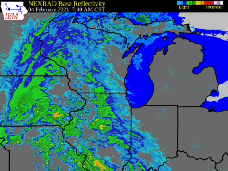 |
WSR-88D Doppler Radar Mosaic from 8 am to 10 pm February 4th
|
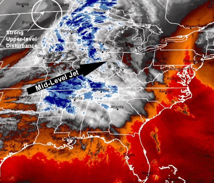 |
GOES-16 Low-Level Water Vapor Satellite. The animation reveals rapid development of the winter storm over the western Great Lakes region between 6 am Thursday February 4th through 6 am Friday February 5th.
|
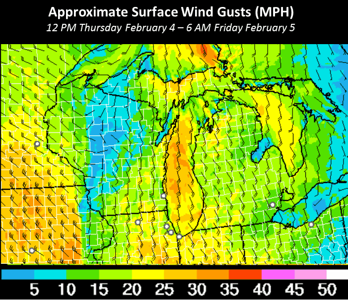 |
Estimated maximum surface wind gusts (mph) derived from the HRRR model.
See the wind tab for peak wind reports from across the area. |
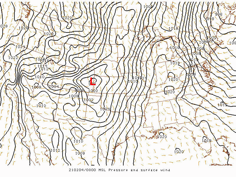 |
RAP Mean Sea Level Pressure Analysis (mb) from 6 pm Wednesday February 3 through 6 am February 5th. Surface wind barbs are also plotted (light brown).
|
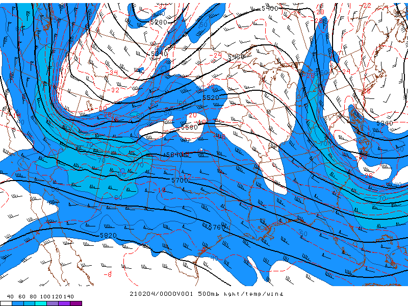 |
RAP Analysis 500 MB Height (Meters - black contours), Wind Speed (Knots - blue shading) and Temperature (Degrees C – red dashed). Valid 6 pm February 3rd to 6 am February 5th.
|
Wind Reports:
Here is a look at the highest wind gusts reported during the winter storm.
The winds create minor blowing and drifting snow across much of the area.
PUBLIC INFORMATION STATEMENT
NATIONAL WEATHER SERVICE GREEN BAY WI
750 AM CST FRI FEB 5 2021

...HIGHEST WIND REPORTS...

LOCATION                     SPEED     TIME/DATE       LAT/LON
--------------------------------------------------------------------
MANITOWOC AIRPORT            41 MPH    1256 AM 02/05   44.12N/87.67W
GREEN BAY AIRPORT            40 MPH    0153 AM 02/05   44.48N/88.13W
MARSHFIELD AIRPORT           40 MPH    0854 PM 02/04   44.63N/90.18W
OSHKOSH AIRPORT              40 MPH    1053 PM 02/04   43.97N/88.55W
WISCONSIN RAPIDS AIRPORT     39 MPH    0654 PM 02/04   44.37N/89.83W
WITTMAN REGIONAL AIRPORT     39 MPH    1153 PM 02/04   43.97N/88.56W
WAUTOMA AIRPORT              39 MPH    0956 PM 02/04   44.03N/89.30W
WAUSAU AIRPORT               37 MPH    0354 AM 02/05   44.93N/89.62W
STURGEON BAY AIRPORT         37 MPH    1156 PM 02/04   44.85N/87.42W
MENOMINEE                    37 MPH    1124 PM 02/04   45.10N/87.59W
MOSINEE AIRPORT              35 MPH    0847 PM 02/04   44.78N/89.67W
EPHRAIM                      33 MPH    1155 PM 02/04   45.13N/87.18W
STEVENS POINT AIRPORT        33 MPH    0335 AM 02/05   44.55N/89.53W
ST NAZIANZ                   32 MPH    1135 PM 02/04   44.01N/87.89W
APPLETON AIRPORT             32 MPH    0545 AM 02/05   44.27N/88.52W
RHINELANDER AIRPORT          31 MPH    0953 PM 02/04   45.63N/89.48W
ANTIGO 2 ENE                 29 MPH    1005 PM 02/04   45.16N/89.11W
OMRO                         29 MPH    1201 AM 02/05   44.07N/88.69W
MERRILL AIRPORT              29 MPH    0355 AM 02/05   45.20N/89.72W
MANITOWOC                    28 MPH    1050 PM 02/04   44.09N/87.66W
WAUPACA                      28 MPH    0335 AM 02/05   44.33N/89.02W
WABENO 2 NNW                 28 MPH    1001 PM 02/04   45.46N/88.68W
WAUTOMA 1 WSW                28 MPH    0112 AM 02/05   44.06N/89.29W
TWO CREEKS                   27 MPH    1120 PM 02/04   44.27N/87.55W
KESHENA 2 WNW                27 MPH    0105 AM 02/05   44.89N/88.66W
WASHINGTON ISLAND            26 MPH    0435 AM 02/05   45.38N/86.92W
MANITOWISH WATERS AIRPORT    26 MPH    0115 AM 02/05   46.12N/89.88W
SHAWANO AIRPORT              26 MPH    1135 PM 02/04   44.78N/88.57W
WASHINGTON ISLAND 1 WSW      26 MPH    1225 AM 02/05   45.36N/86.93W
CLINTONVILLE AIRPORT         25 MPH    0415 AM 02/05   44.62N/88.73W
EAGLE RIVER AIRPORT          25 MPH    0955 PM 02/04   45.93N/89.27W


OBSERVATIONS ARE COLLECTED FROM A VARIETY OF SOURCES WITH VARYING
EQUIPMENT AND EXPOSURES. WE THANK ALL VOLUNTEER WEATHER OBSERVERS
FOR THEIR DEDICATION. NOT ALL DATA LISTED ARE CONSIDERED OFFICIAL.
 |
Media use of NWS Web News Stories is encouraged! Please acknowledge the NWS as the source of any news information accessed from this site. |
|


.png)