Overview
|
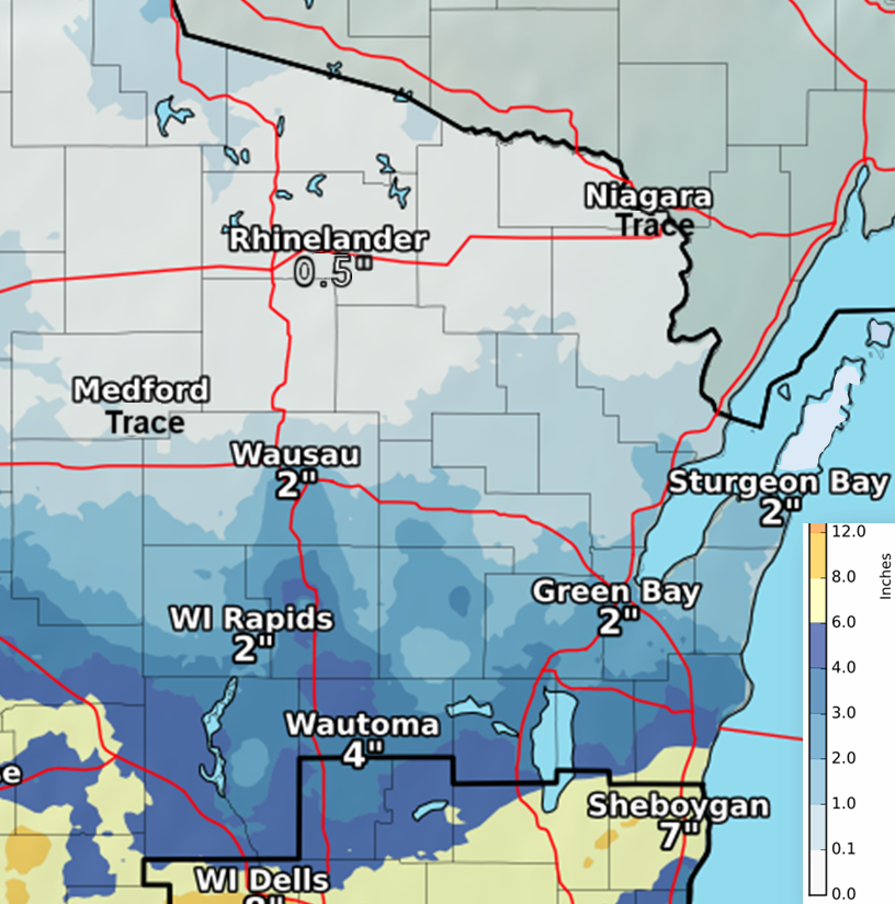
Accumulating snow was observed across much of the area January 25-26, 2017. The snow developed as an area of low pressure moved south of the area. The highest snowfall totals were found across southern Manitowoc County, with amounts approaching 7 inches. Much of the north only saw an inch or less. Snowfall accumulations across portions of central and east-central WI were a little shy of forecast totals. This was mainly due to above freezing surface temps and a slightly thawed ground that allowed the snow to melt and compact throughout the day. Plus, some of the precipitation fell as rain and drizzle. Green Bay received 0.4” of liquid during the event, which, with a 10:1 snow ratio, would be 4 inches of snow. However, we never saw that amount actually on the ground, as Green Bay ended up with 2.5” of snow. Ground temps were just a little too warm for higher accumulations. See the tabs below for the snowfall and liquid water equivalent (melted snow, drizzle, rain) reports from across northeast Wisconsin.
|
 January 25-26 Snowfall. Click for larger image. |
Snowfall Reports
Here is a sample of snowfall reports from across northeast Wisconsin.
...Preliminary Snowfall Totals For January 25-26...

Location                     Amount    Time/Date       Provider

...Wisconsin...

...Brown County...
Denmark Wwtp                 2.3 in    0800 AM 01/26   COOP
NWS Green Bay                2.5 in    0600 AM 1/26    NWS GREEN BAY

...Calumet County...
New Holstein - East - Wwtp   3.0 in    0800 AM 01/26   UCOOP
Chilton                      2.9 in    0700 AM 01/26   COCORAHS
Darboy 3 SE                  2.6 in    0700 AM 01/26   COCORAHS

...Door County...
Sturgeon Bay Exp Farm        1.5 in    0730 AM 01/26   COOP

...Manitowoc County...
Two Rivers 2 NW              2.5 in    0533 AM 01/26   COCORAHS

...Outagamie County...
Shiocton                     3.5 in    0743 AM 01/26   COOP
Appleton                     3.2 in    0700 AM 01/26   COOP

...Portage County...
Almond-5 Ne                  4.3 in    0800 AM 01/26   UCOOP

...Shawano County...
Split Rock 1 NNW             3.2 in    0800 AM 01/26   COCORAHS

...Vilas County...
Boulder Junction 9 ENE       1.7 in    0725 AM 01/26   COCORAHS

...Waupaca County...
Waupaca                      2.0 in    0800 AM 01/26   COOP

...Waushara County...
Wautoma Silver Lake Sanitary 5.3 in    0830 AM 01/26   COOP
Hancock Exp Farm             3.8 in    0800 AM 01/26   COOP

...Winnebago County...
Omro 1 WSW                   3.7 in    0700 AM 01/26   COCORAHS
Neenah                       3.3 in    0700 AM 01/26   COCORAHS
Liquid Water Equivalent Reports
Here is a sample of liquid water equivalent (melted snow, drizzle, rain) reports from across northeast Wisconsin.
...Liquid Water Equivelent Reports From January 25-26...

Location                     Amount    Time/Date       Provider

...Wisconsin...

...Brown County...
NWS Green Bay                0.40 in   0600 AM 01/26   NWS GREEN BAY
De Pere                      0.35 in   1210 PM 01/26   CWOP
Howard 2 WNW                 0.34 in   1223 PM 01/26   CWOP
Denmark Wwtp                 0.33 in   0800 AM 01/26   COOP

...Calumet County...
Chilton                      0.52 in   0700 AM 01/26   COCORAHS
Darboy 3 SE                  0.45 in   0700 AM 01/26   COCORAHS
New Holstein - East - Wwtp   0.41 in   0800 AM 01/26   UCOOP

...Door County...
Sister Bay 1 N               0.30 in   0700 AM 01/26   COCORAHS
Sturgeon Bay Exp Farm        0.26 in   0730 AM 01/26   COOP

...Kewaunee County...
Kewaunee                     0.41 in   0700 AM 01/26   COOP

...Manitowoc County...
Two Rivers 2 NW              0.76 in   0533 AM 01/26   COCORAHS

...Marinette County...
Peshtigo                     0.22 in   0730 AM 01/26   COOP

...Menominee County...
Keshena 2 WNW                0.29 in   1205 PM 01/26   RAWS

...Oconto County...
Pulaski - Wwtp               0.40 in   0700 AM 01/26   COOP
Oconto 4 W                   0.32 in   0700 AM 01/26   COOP

...Outagamie County...
Appleton                     0.46 in   0700 AM 01/26   COOP
Appleton Whby Radio          0.38 in   0805 AM 01/26   UCOOP
Shiocton                     0.36 in   0743 AM 01/26   COOP

...Portage County...
Amherst 3 SE                 0.49 in   0700 AM 01/26   UCOOP
Almond-5 Ne                  0.42 in   0800 AM 01/26   UCOOP

...Shawano County...
Split Rock 1 NNW             0.29 in   0800 AM 01/26   COCORAHS
Shawano 2 SSW                0.24 in   0800 AM 01/26   COOP
Angelica                     0.22 in   0700 AM 01/26   COCORAHS
Stockbridge-munsee Reservati 0.22 in   0848 AM 01/26   COOP

...Waupaca County...
Waupaca                      0.29 in   0800 AM 01/26   COOP
New London                   0.27 in   1100 AM 01/26   HADS
Clintonville                 0.24 in   0700 AM 01/26   COOP
Waupaca 3 E                  0.21 in   1100 AM 01/26   USARMY-COE
Lt Wolf. River               0.21 in   1200 PM 01/26   GOES

...Waushara County...
Wautoma Silver Lake Sanitary 0.52 in   0830 AM 01/26   COOP
Wautoma 1 WSW                0.52 in   1212 PM 01/26   RAWS
Hancock Exp Farm             0.32 in   0800 AM 01/26   COOP

...Winnebago County...
Oshkosh                      0.52 in   0700 AM 01/26   COCORAHS
Neenah                       0.51 in   0700 AM 01/26   COCORAHS
Lake Winnebago               0.50 in   1200 PM 01/26   GOES

...Wood County...
Pittsville - Wwtp            0.26 in   0700 AM 01/26   UCOOP
Port Edwards 2 WNW           0.25 in   1207 PM 01/26   CWOP

Observations are collected from a variety of sources with varying
equipment and exposures. Not all data listed are considered official.
 |
Media use of NWS Web News Stories is encouraged! Please acknowledge the NWS as the source of any news information accessed from this site. |
 |