The January 12-13, 2024 Winter Storm
|
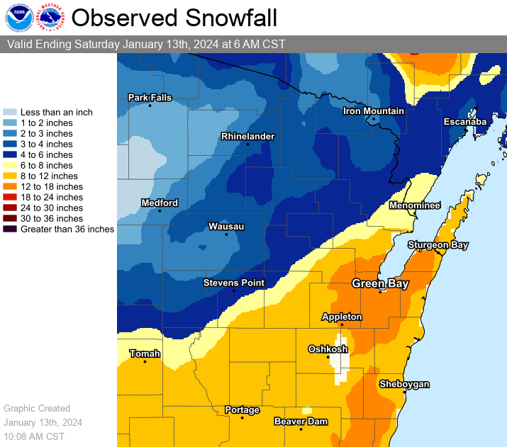
Event Overview A strong low pressure system storm moved from the southern Plains northeast into the central Great Lakes, bringing near-blizzard conditions to the southeast half of Wisconsin from January 12 to early January 13, 2024. The low pressure system strengthened rapidly as it approached southern lower Michigan by early evening January 12. By 6 am Saturday January 13, the storm dumped a swath of heavy wet snow that was accompanied by very strong northeast winds that created 2-3 foot snow drifts. The highest snow totals (~18 inches), were associated with a relatively narrow lake-enhanced snow band that meandered over far northern Brown, southern Oconto and Door counties. The snow band produced snowfall rates up to 2 inches per hour and near whiteout conditions at times. The intense surface low pressure developed in associated with strong upper-level jet stream energy that dove southward into Texas a few days earlier, then raced northeast toward the Great Lakes Region. Roads quickly became snow covered, making for hazardous travel conditions. Some school activities and businesses were closed Friday into Saturday. Winds of 35 to 55 mph caused sporadic power outages with over 100,000 customers losing power during the storm. On Lake Michigan, winds gusted to around 40-45 kts and created waves of 10 to 18 feet.
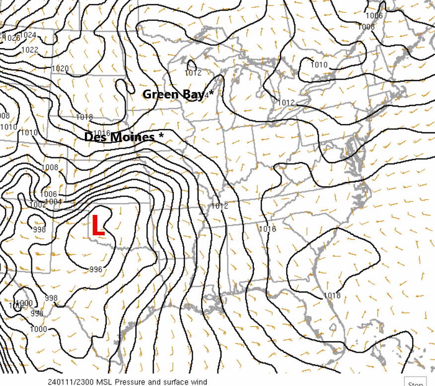
RAP Analysis - Wind Barbs and Mean Sea Level Pressure (MSL). The track of the low pressure system is denoted by the "L" on the analysis.
Please see tabs below for more information. |
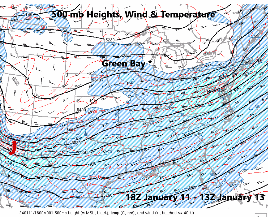
RAP Analysis - Wind Barbs, Wind speed (shaded) and Heights (solid black lines). Red "J" denotes the approximate location of strong jet maximum. Analysis is at 500 mb. |
Snow Reports
...PRELIMINARY SNOWFALL REPORTS...

Location                     Amount    Time/Date       Lat/Lon

...Wisconsin...

...Brown County...
Suamico                      18.0 in   1036 AM 01/13   44.63N/88.05W
Howard                       17.0 in   1034 AM 01/13   44.56N/88.06W
Suamico                      17.0 in   1032 AM 01/13   44.63N/88.05W
2 ENE Oneida                 15.0 in   1036 AM 01/13   44.52N/88.16W
De Pere                      14.0 in   0852 AM 01/13   44.45N/88.06W
NWS Green Bay                13.5 in   0600 AM 01/13   44.50N/88.11W
3 SE De Pere                 13.0 in   0933 AM 01/13   44.42N/88.01W
Green Bay 3.8 SSE            13.0 in   0700 AM 01/13   44.47N/87.97W
2 WNW Ashwaubenon            11.8 in   1200 AM 01/13   44.50N/88.11W
Wrightstown                  11.5 in   0738 AM 01/13   44.33N/88.17W

...Calumet County...
Chilton 0.5 E                12.0 in   0700 AM 01/13   44.03N/88.15W
2 SSW High Cliff State Park  11.0 in   1013 AM 01/13   44.14N/88.29W

...Door County...
1 SSE Institute              16.0 in   0900 AM 01/13   44.89N/87.30W
Sturgeon Bay                 14.4 in   0735 AM 01/13   44.83N/87.38W
Sister Bay                   12.8 in   1130 PM 01/12   45.18N/87.11W

...Florence County...
Spread Eagle 1 NW            3.0 in    0700 AM 01/13   45.89N/88.14W

...Forest County...
Argonne 1.5 NW               3.8 in    0736 AM 01/13   45.67N/88.90W

...Kewaunee County...
2 WNW Luxemburg              15.0 in   0848 AM 01/13   44.54N/87.72W
Casco 0.4 NNW                7.5 in    0703 AM 01/13   44.56N/87.62W

...Lincoln County...
Tomahawk 1.2 SSW             3.5 in    0700 AM 01/13   45.46N/89.73W
Merrill 8 W                  3.2 in    0600 AM 01/13   45.18N/89.85W
Harrison                     3.0 in    0855 AM 01/13   45.48N/89.50W
Bradley 1.0 NE               2.4 in    0700 AM 01/13   45.54N/89.73W

...Manitowoc County...
2 E Millhome                 15.1 in   0715 AM 01/13   43.90N/87.91W
Millhome 2 E                 15.1 in   0715 AM 01/13   43.90N/87.91W
2 NW Two Rivers              11.7 in   0700 AM 01/13   44.18N/87.58W
2 NW Two Rivers              11.7 in   0700 AM 01/13   44.18N/87.58W
Manitowoc 1.4 NW             9.7 in    0700 AM 01/13   44.11N/87.69W
Two Rivers                   9.2 in    0931 AM 01/13   44.15N/87.56W

...Marathon County...
Wausau WSAW TV               4.1 in    1100 PM 01/12   44.95N/89.62W
Weston 1 NE                  2.7 in    0700 AM 01/13   44.92N/89.54W
Stratford 1 NW               2.3 in    0729 AM 01/13   44.82N/90.09W

...Marinette County...
Peshtigo 1 S                 8.0 in    0730 AM 01/13   45.03N/87.74W

...Oconto County...
Oconto Falls 1.0 SE          10.7 in   0615 AM 01/13   44.86N/88.13W
Mountain 0.9 E               4.3 in    0700 AM 01/13   45.18N/88.46W

...Oneida County...
Rhinelander 5.5 NW           3.2 in    0600 AM 01/13   45.70N/89.48W
Rhinelander                  3.2 in    1130 PM 01/12   45.62N/89.41W
Hazelhurst 2.1 SSE           2.0 in    0700 AM 01/13   45.78N/89.70W
Minocqua                     2.0 in    0630 AM 01/13   45.89N/89.73W

...Outagamie County...
Kaukauna                     15.0 in   0857 AM 01/13   44.26N/88.26W
3 NE Appleton                11.5 in   0927 AM 01/13   44.29N/88.37W
1 NE Shiocton                10.0 in   0843 AM 01/13   44.45N/88.56W
New London 4.1 N             9.0 in    0600 AM 01/13   44.45N/88.73W

...Portage County...
Amherst 3 SE                 8.0 in    0700 AM 01/13   44.41N/89.26W
Amherst 2.6 SSE              8.0 in    0700 AM 01/13   44.41N/89.26W
Rosholt                      5.3 in    0931 AM 01/13   44.63N/89.30W
Rudolph 1 NNE                3.2 in    0500 AM 01/13   44.53N/89.79W

...Shawano County...
1 NW Tigerton                8.0 in    0925 AM 01/13   44.74N/89.06W
Shawano 2 SSW                7.5 in    0800 AM 01/13   44.76N/88.62W
Shawano                      7.5 in    0800 AM 01/13   44.78N/88.59W
Shawano 5.3 WNW              5.8 in    0713 AM 01/13   44.80N/88.69W

...Vilas County...
Boulder Junction 9 ENE       2.7 in    0700 AM 01/13   46.19N/89.46W
Boulder Junction 1.4 NE      2.1 in    0700 AM 01/13   46.13N/89.62W
St Germain 0.6 NW            1.9 in    0700 AM 01/13   45.92N/89.49W

...Waupaca County...
Manawa                       13.5 in   0859 AM 01/13   44.46N/88.91W
Clintonville                 13.5 in   0735 AM 01/13   44.61N/88.75W
Manawa 3.6 SSW               13.5 in   0700 AM 01/13   44.41N/88.95W
Scandinavia                  12.3 in   0951 AM 01/13   44.46N/89.13W

...Waushara County...
Wild Rose 0.5 E              9.6 in    0700 AM 01/13   44.18N/89.24W

...Winnebago County...
2 NNE Oshkosh                10.0 in   0819 AM 01/13   44.03N/88.54W
Omro 1 WSW                   9.0 in    0700 AM 01/13   44.02N/88.78W
Zittau                       9.0 in    0600 AM 01/13   44.22N/88.78W
Oshkosh                      5.1 in    0700 AM 01/13   44.03N/88.56W

...Wood County...
Wisconsin Rapids             6.0 in    0600 AM 01/13   44.39N/89.83W
Pittsville - WWTP            2.5 in    0600 AM 01/13   44.44N/90.13W


Observations are collected from a variety of sources with varying
equipment and exposures. We thank all volunteer weather observers
for their dedication. Not all data listed are considered official.
Records Set
Green Bay
Daily Snowfall Record for January 12 - 11.8" (Previous record was 11.5" in 1890)
Appleton
Daily Snowfall Record for January 12 - 9.5" (Previous record was 6.5" in 1966)
Wisconsin Rapids
Daily Snowfall Record for January 12 - 6.0" (Previous record was 5.0" in 1988)
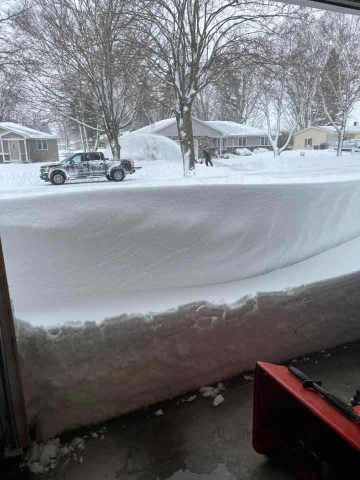
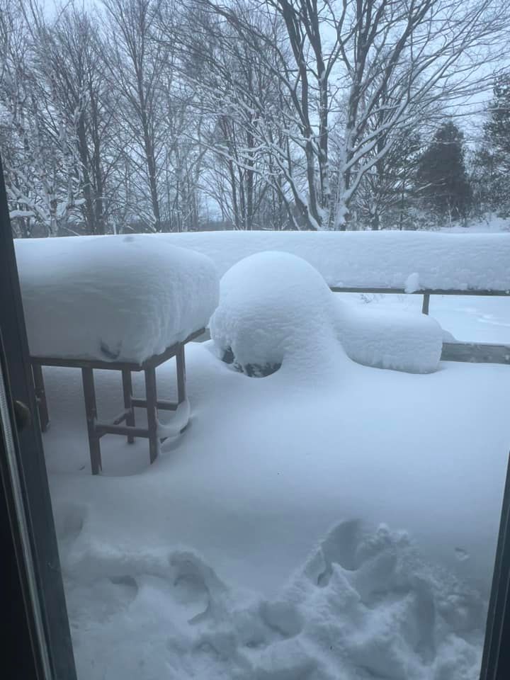
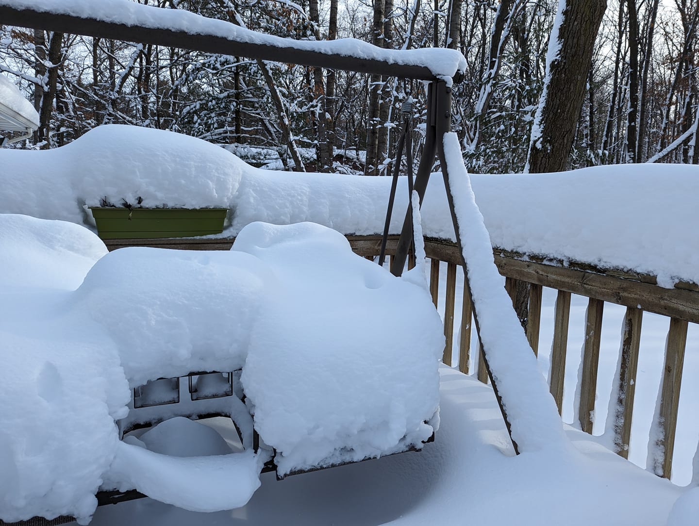
Photos:
 |
 |
 |
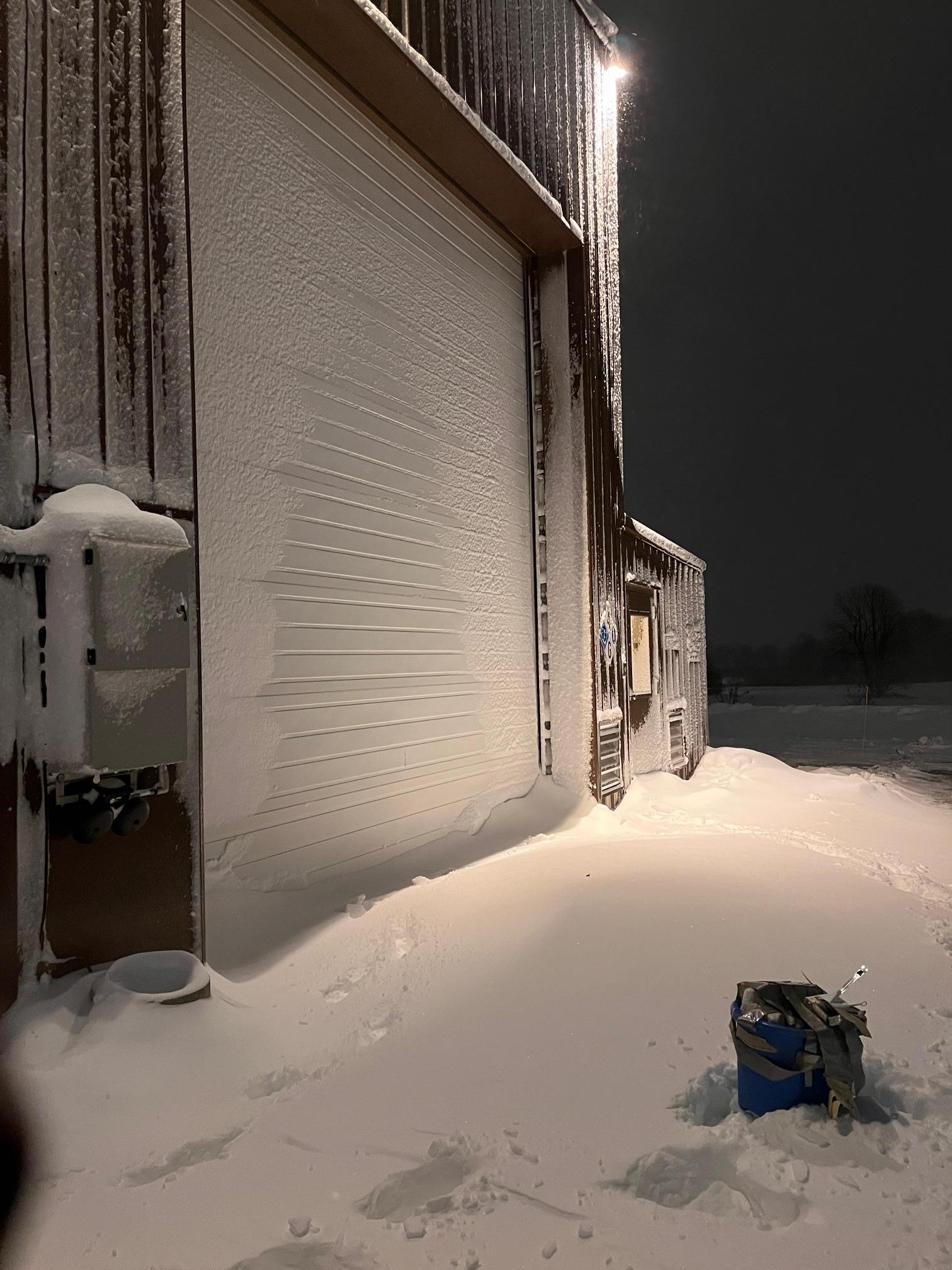 |
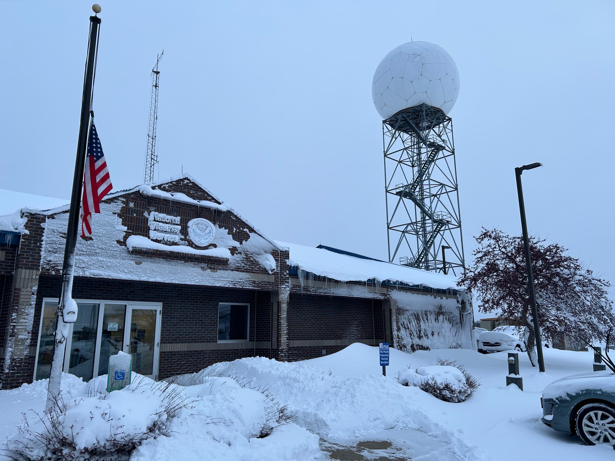
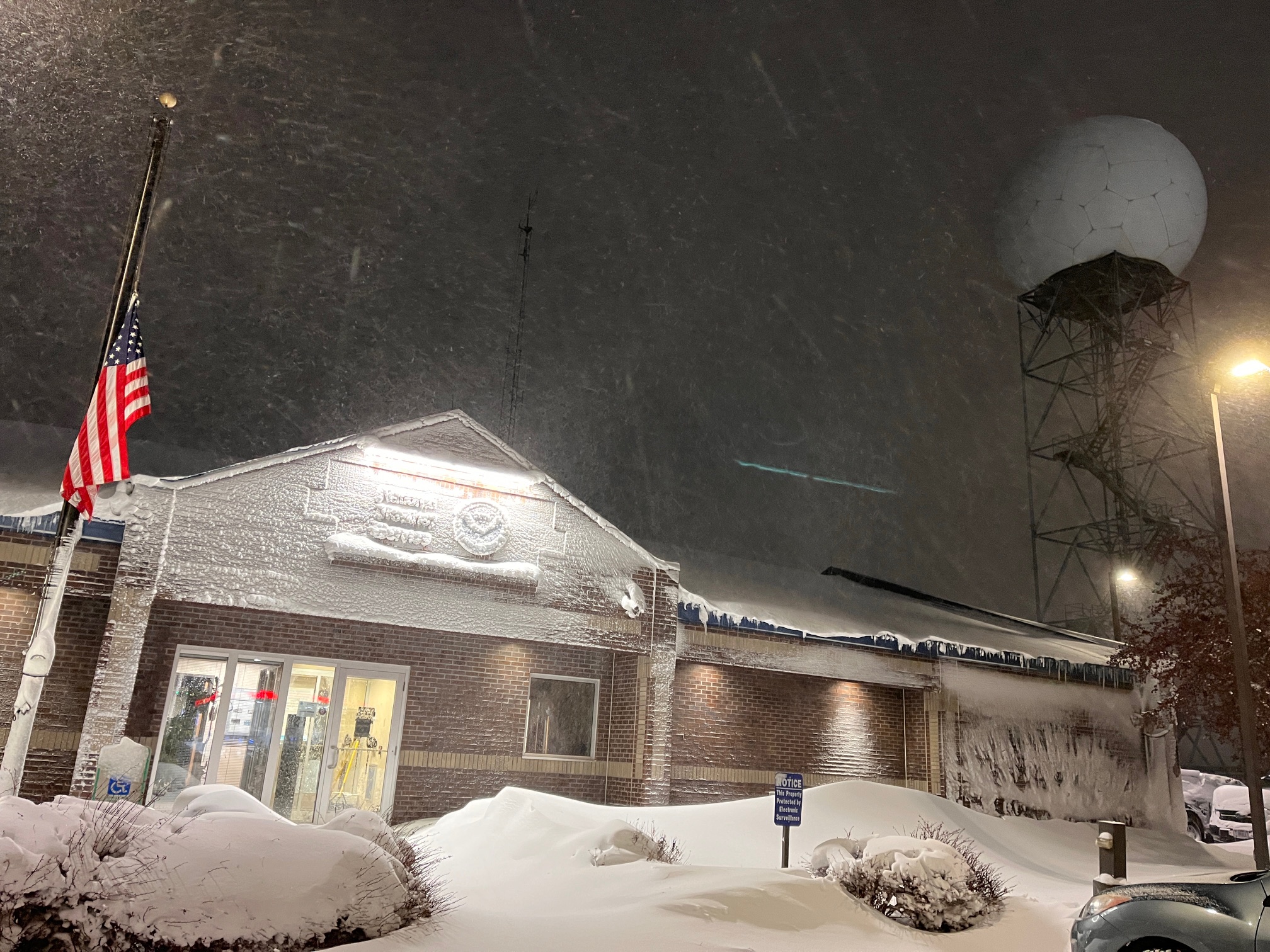
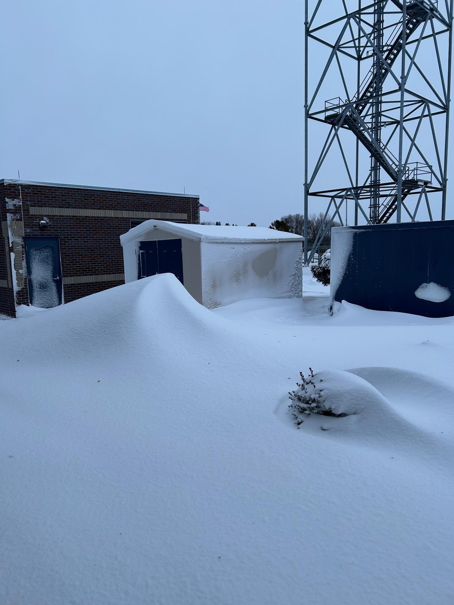
| NWS Green Bay Office | NWS Green Bay Office | NWS Green Bay Office | NWS Green Bay Upper Air Building |
 |
 |
 |
|
| Algoma Courtesy of DeeDee Sternard |
Sevastopol Courtesy of Shelly Cook Bath |
Suamico Courtesy of Cindy Albin |
|
Satellite & Radar:
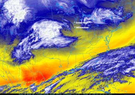
Low-level GOES-16 Water Vapor Animation Showing the Storm Evolution
Radar loop from midnight Jan 12, 2024 to midnight Jan 13, 2024
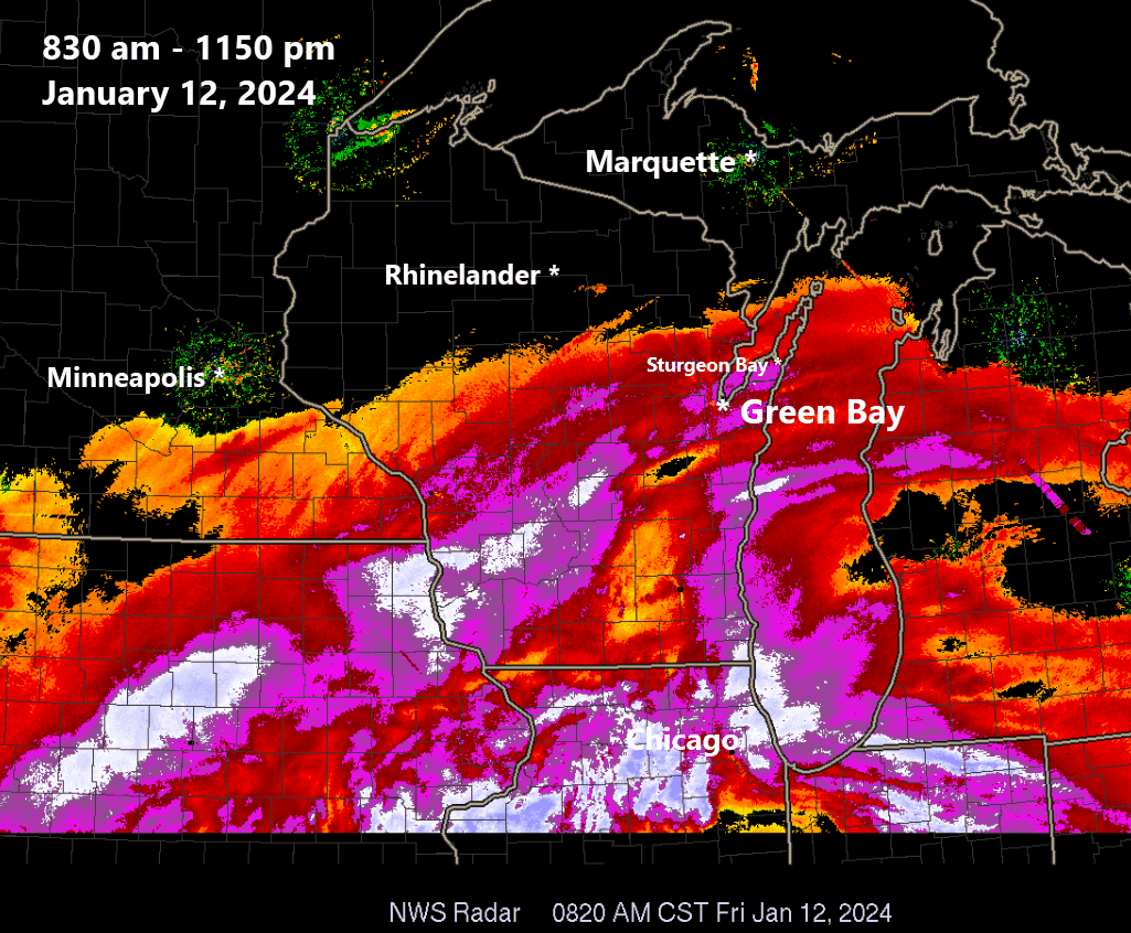
Enhanced radar loop. The white/dark purple colored areas denote hourly snowfall rates of 1-2 inches per hour. Note the SW-NE orientated snow band near and just north of Green Bay. This the area that received the highest snowfall.
Peak Winds
...PEAK 24-HOUR WIND GUST REPORTS...

Location                     Speed     Time/Date       Lat/Lon
--------------------------------------------------------------------
Green Bay Airport            54 MPH    0654 PM 01/12   44.48N/88.13W
Kewaunee MET, WI             54 MPH    0848 PM 01/12   44.47N/87.50W
Menominee                    54 MPH    0842 PM 01/12   45.10N/87.59W
I-43 Se End Of Leo Frigo Bri 54 MPH    0818 PM 01/12   44.51N/88.04W
Oshkosh Airport              52 MPH    0815 PM 01/12   43.97N/88.55W
Gills Rock 1 ENE             51 MPH    0700 AM 01/13   45.29N/86.98W
Two Creeks                   47 MPH    0820 PM 01/12   44.27N/87.55W
Sturgeon Bay Airport         47 MPH    0702 AM 01/13   44.85N/87.42W
Chambers Island 1 NNW        46 MPH    0940 PM 01/12   45.20N/87.36W
Green Bay 1 N                44 MPH    0800 PM 01/12   44.54N/88.00W
De Pere                      40 MPH    0750 PM 01/12   44.44N/88.05W
Ephraim                      40 MPH    0515 AM 01/13   45.13N/87.18W
Manitowoc Airport            40 MPH    0243 PM 01/12   44.12N/87.67W
Antigo 2 ENE                 39 MPH    0805 PM 01/12   45.16N/89.11W
Washington Island            39 MPH    0715 AM 01/13   45.38N/86.92W
Antigo Airport               39 MPH    0355 AM 01/13   45.15N/89.12W
Ellison Bay 2.2 S (MAWN)     39 MPH    0645 AM 01/13   45.22N/87.07W
Egg Harbor 3.1 SE (MAWN)     39 MPH    0850 PM 01/12   45.01N/87.23W
Appleton Airport             38 MPH    1045 PM 01/12   44.27N/88.52W
Wisconsin Rapids Airport     37 MPH    0204 PM 01/12   44.37N/89.83W
Marshfield Airport           37 MPH    0346 AM 01/13   44.63N/90.18W
Forest Junction              36 MPH    0455 AM 01/13   44.21N/88.21W
Mosinee Airport              36 MPH    0515 AM 01/13   44.78N/89.67W
Eagle River Airport          36 MPH    0555 AM 01/13   45.93N/89.27W
Wausau Airport               35 MPH    0755 AM 01/13   44.93N/89.62W
Clintonville Airport         35 MPH    0135 PM 01/12   44.62N/88.73W
Oconto Airport               33 MPH    0635 PM 01/12   44.87N/87.92W
Stevens Point Airport        33 MPH    0255 PM 01/12   44.55N/89.53W
Wautoma Airport              33 MPH    0655 PM 01/12   44.03N/89.30W
Shawano Airport              32 MPH    0715 PM 01/12   44.78N/88.57W
Land O Lakes                 31 MPH    0535 AM 01/13   46.15N/89.22W
Rhinelander Airport          31 MPH    0321 PM 01/12   45.63N/89.48W
Merrill Airport              31 MPH    0635 AM 01/13   45.20N/89.72W
Arbor Vitae Airport          30 MPH    0415 AM 01/13   45.92N/89.72W

Observations are collected from a variety of sources with varying
equipment and exposures. We thank all volunteer weather observers
for their dedication. Not all data listed are considered official.
A meteogram of wind speed (red line) and wind gusts (green plus signs) at Green Bay, Wisconsin. Note that the strongest winds (at Green Bay) occurred between about 6 pm (00Z) and 8 pm (02Z). The peak gust of 54 mph was recorded at 654 pm CST.
 |
Media use of NWS Web News Stories is encouraged! Please acknowledge the NWS as the source of any news information accessed from this site. |
|


.jpg)