Overview
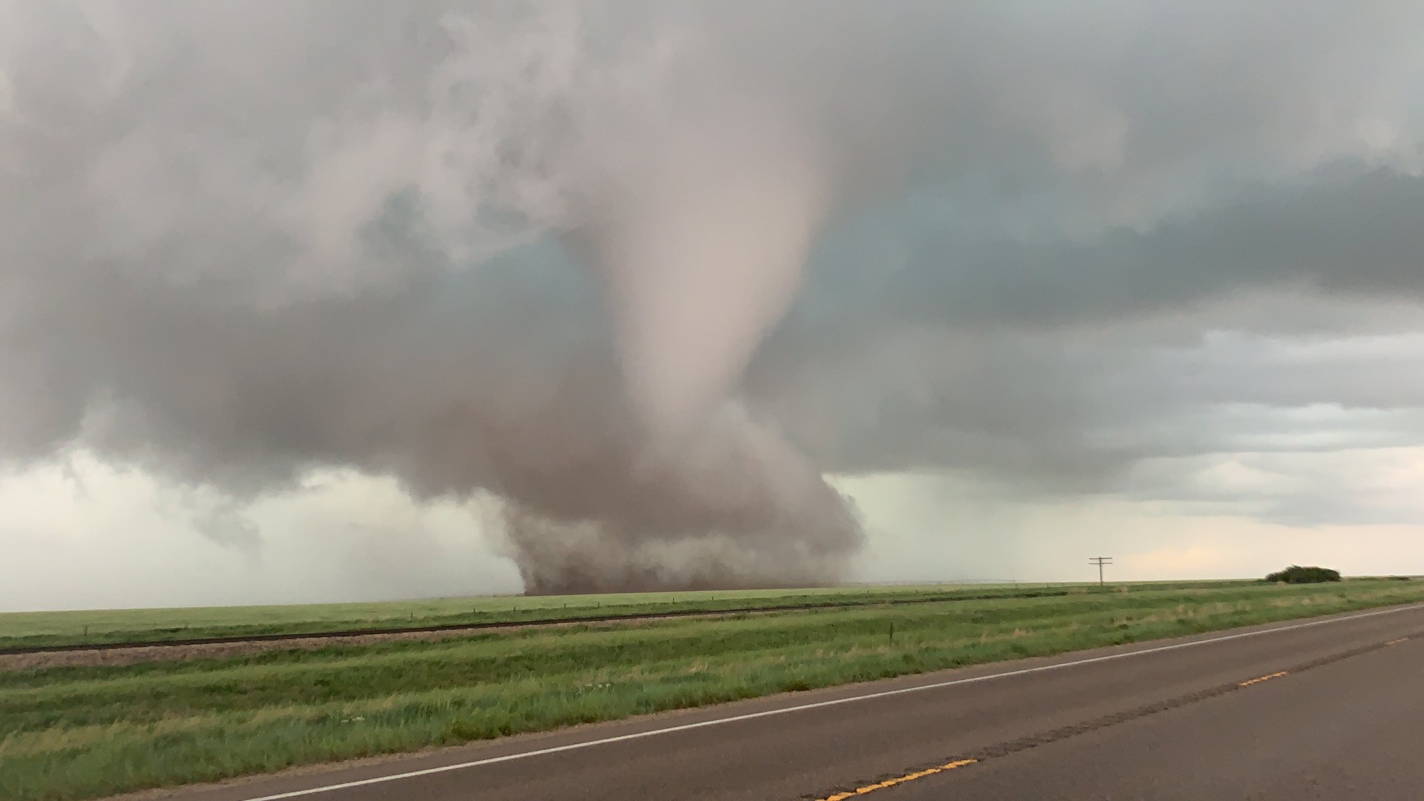
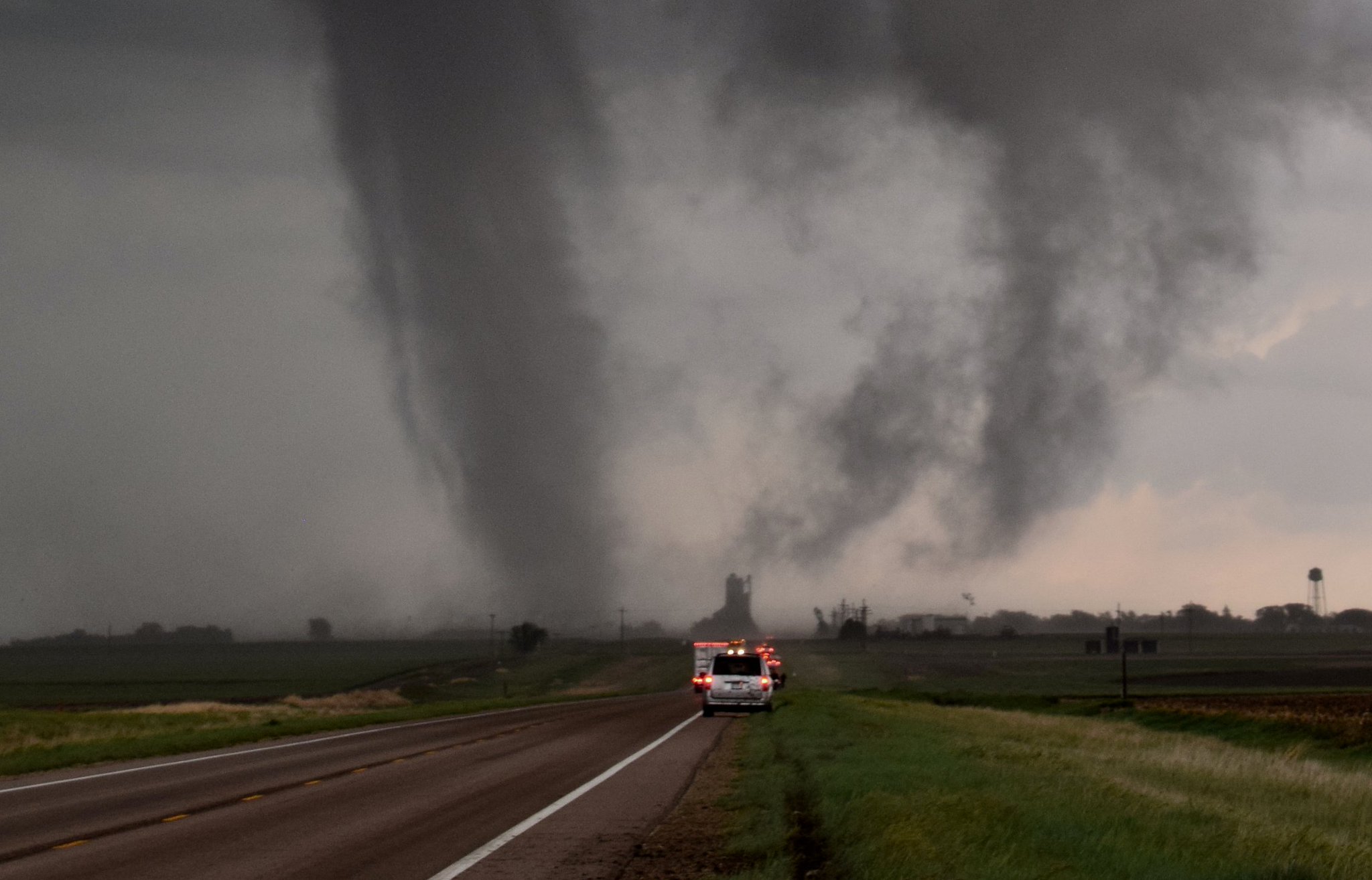
May 24th, 2021 was a day in which northwest Kansas won't forget for a while. On this day, numerous tornadoes occurred across the region. A cold front had moved through the area on May 23rd, and on May 24th, was stalled across western Kansas. During the early afternoon, storms began to form along and just north of the cold front. Several of them quickly became tornadic, eventually producing tornadoes across Wallace, Logan, Thomas, and Sheridan Counties. The most significant storm formed right over Colby, KS around 3:30 pm CDT. This storm eventually produced a tornado just northeast of Colby, KS at around 4:16 CDT. The storm progressed to the northeast, producing funnel clouds and tornadoes up until it moved into far northwestern Sheridan County. As the storm approached Selden, KS, a tornado formed around four miles west of town. The tornado slowly moved to the east, eventually crossing Highway 83 and moving into town. It was here the most significant damage of the day was observed as a multi-vortex tornado pushed through town, producing high-end EF-1 damage with estimated wind speeds of around 110 mph. The tornado then turned left, moving northeast out of town along Highway 83. The tornado eventually dissipated around the Highway 83 and Highway 383 junction.
Tornadoes are still being counted and this page will provide preliminary storm information on this memorable event. The page will be updated as more information becomes available. No additional storm surveys are planned at this time.
Tornadoes:
|
SELDEN, KS
|
||||||||||||||||
The Enhanced Fujita (EF) Scale classifies tornadoes into the following categories:
| EF0 Weak 65-85 mph |
EF1 Moderate 86-110 mph |
EF2 Significant 111-135 mph |
EF3 Severe 136-165 mph |
EF4 Extreme 166-200 mph |
EF5 Catastrophic 200+ mph |
 |
|||||
Photos & Video
(click image to enlarge)
 |
 |
 |
| Selden, KS Tornado Credit: Brandon and Lauren Morris |
3 miles west of Selden, KS Credit: Chad Griffin |
Tornado near Selden, KS Credit: Jacob Terrell |
 |
 |
 |
| Selden, KS tornado Credit: Jesse Risley |
Close-up of the Selden tornado Credit: Matthew Cappucci |
Image of Selden, KS Tornado Credit: Jesse Risley |
 |
 |
 |
|
Damage in Selden, KS Credit: NWS Damage Assessment |
Damage in Selden, KS Credit: NWS Damage Assessment |
Damage in Selden, KS Credit: NWS Damage Assessment |
 |
 |
 |
|
Damage in Selden, KS Credit: NWS Damage Assessment |
Damage in Selden, KS Credit: NWS Damage Assessment |
Damage in Selden, KS Credit: NWS Damage Assessment |
 |
 |
 |
|
Damage in Selden, KS Credit: NWS Damage Assessment |
Damage in Selden, KS Credit: NWS Damage Assessment |
Damage in Selden, KS Credit: NWS Damage Assessment |
— Brittany Newman (@Sturms112010) May 24, 2021 |
|
|
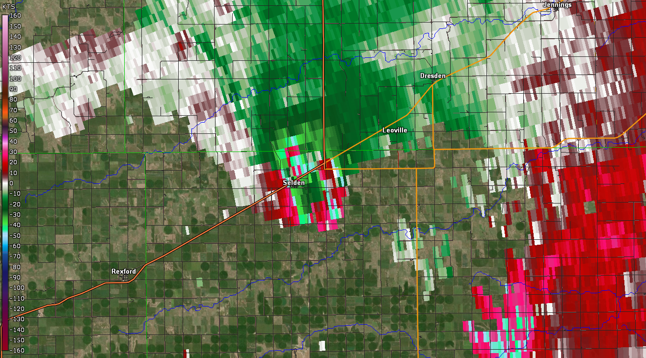
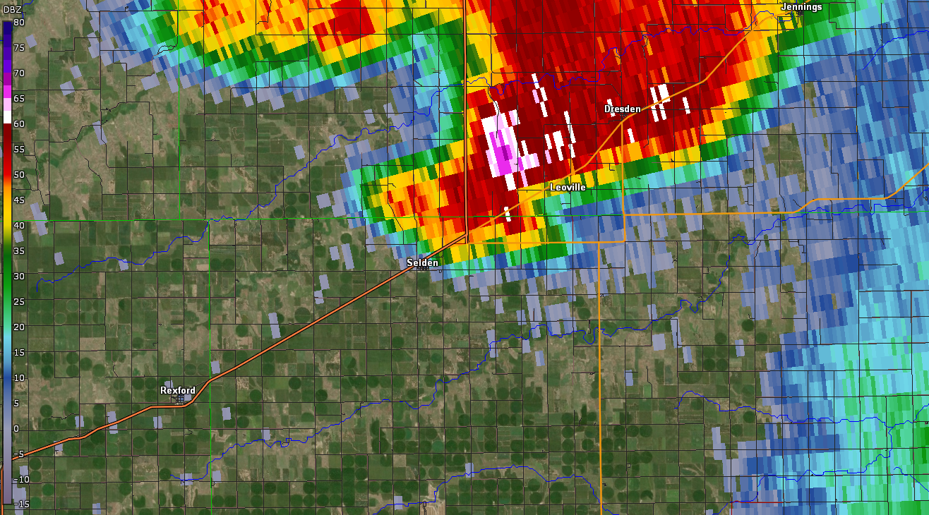
Radar
(click image to enlarge)
 |
 |
 |
 |
| Radar Reflectivity around the time the Selden, KS Tornado began. | Radar Storm Relative Velocity around the time the Selden, KS Tornado began. | Radar Reflectivity shortly after the Selden, KS Tornado began. | Radar Storm Relative Velocity shortly after the Selden, KS Tornado began. |
 |
 |
 |
 |
| Radar Reflectivity at the time the tornado was impacting Selden, KS. | Radar Storm Relative Velocity at the time the tornado was impacting Selden, KS. | Radar Correlation Coefficient at the time the tornado was impacting Selden, KS. The large are of low CC indicates debris in the air as sampled by radar. | Radar Differential Reflectivity at the time the tornado was impacting Selden, KS. The large are of low ZDR indicates debris in the air as sampled by radar. |
 |
 |
 |
 |
| Radar Reflectivity around the time the Selden, KS Tornado was dissipating. | Radar Storm Relative Velocity around the time the Selden, KS Tornado was dissipating. | Radar Reflectivity around the time the Selden, KS Tornado was dissipating. | Radar Storm Relative Velocity around the time the Selden, KS Tornado was dissipating. |
Storm Reports
For a map of all preliminary storm reports, please see this website.
PRELIMINARY LOCAL STORM REPORT...SUMMARY
NATIONAL WEATHER SERVICE GOODLAND KS
540 PM MDT TUE MAY 25 2021
..TIME... ...EVENT... ...CITY LOCATION... ...LAT.LON...
..DATE... ....MAG.... ..COUNTY LOCATION..ST.. ...SOURCE....
..REMARKS..
0206 PM TORNADO 11 NNE WALLACE 39.06N 101.52W
05/24/2021 WALLACE KS TRAINED SPOTTER
DISPATCH RELAYED A SPOTTER REPORT OF A BRIEF
TORNADO.
0208 PM TORNADO 8 NW WINONA 39.15N 101.35W
05/24/2021 THOMAS KS TRAINED SPOTTER
DISPATCH RELAYED A SPOTTER REPORT OF A BRIEF
TORNADO.
0212 PM TORNADO 14 NNE WALLACE 39.10N 101.51W
05/24/2021 WALLACE KS TRAINED SPOTTER
TRAINED SPOTTER REPORTED TORNADO ON GROUND
AT TIME OF REPORT. 8 MILES NW OF MCALLASTER.
0213 PM TORNADO 12 WNW WINONA 39.10N 101.46W
05/24/2021 LOGAN KS PUBLIC
REPORT OF 2 TORNADOES ON THE GROUND AT THE
SAME TIME, ONE APPEARED TO BE A LANDSPOUT.
0218 PM FUNNEL CLOUD 9 NW WINONA 39.16N 101.35W
05/24/2021 THOMAS KS PUBLIC
FUNNEL CLOUD REPORTED.
0250 PM TORNADO 12 NNW WALLACE 39.08N 101.67W
05/24/2021 WALLACE KS PUBLIC
CORRECTS PREVIOUS TORNADO REPORT FROM 12 NNW
WALLACE. CALLER REPORTED SEEING TORNADO ON
THE GROUND FAR NORTH OF SHARON SPRINGS.
0300 PM FLASH FLOOD 15 N LEOTI 38.70N 101.37W
05/24/2021 WICHITA KS LAW ENFORCEMENT
REPORTS OF WATER OVER THE ROAD DEEP ENOUGH
FOR KS-25 TO BE BARRICADED AT HACKBERRY
CREEK. ESTIMATED TIME OF REPORT.
0304 PM FUNNEL CLOUD 3 NE COLBY 39.41N 101.01W
05/24/2021 THOMAS KS PUBLIC
SHORT LIVED FUNNEL CLOUD REPORTED NE OF
COLBY BY PUBLIC.
0315 PM TORNADO 10 SSE BREWSTER 39.24N 101.30W
05/24/2021 THOMAS KS TRAINED SPOTTER
REPORTED SMALL ROPE TORNADO NNW OF WINONA,
KS. DELAYED REPORT.
0316 PM TORNADO 8 SSW LEVANT 39.27N 101.26W
05/24/2021 THOMAS KS TRAINED SPOTTER
SMALL SHORT LIVED TORNADO REPORTED BY
SPOTTER.
0316 PM TORNADO 4 NE COLBY 39.43N 101.00W
05/24/2021 THOMAS KS LAW ENFORCEMENT
LAW ENFORCEMENT REPORTED TORNADO BRIEFLY
TOUCHED GROUND NE OF COLBY BEFORE LIFTING
BACK UP.
0323 PM TORNADO 3 WNW GEM 39.44N 100.96W
05/24/2021 THOMAS KS TRAINED SPOTTER
SPOTTER REPORTS TORNADO WEST OF GEM, KS.
0328 PM FUNNEL CLOUD 3 WNW GEM 39.44N 100.96W
05/24/2021 THOMAS KS TRAINED SPOTTER
0340 PM FUNNEL CLOUD 4 NNE COLBY 39.43N 101.01W
05/24/2021 THOMAS KS PUBLIC
SOCIAL MEDIA PICTURE OF A FUNNEL CLOUD.
0345 PM TORNADO 5 NNW GEM 39.49N 100.92W
05/24/2021 THOMAS KS TRAINED SPOTTER
TRAINED SPOTTER REPORTED BRIEF TORNADO. ALSO
REPORTED VIA SOCIAL MEDIA.
0359 PM FUNNEL CLOUD 5 N GEM 39.49N 100.90W
05/24/2021 THOMAS KS PUBLIC
PICTURE FROM SOCIAL MEDIA OF A FUNNEL CLOUD
NORTH OF GEM, KS.
0413 PM TSTM WND GST 15 SSE RUSSELL SPRINGS 38.72N 101.06W
05/24/2021 E60 MPH LOGAN KS PUBLIC
ESTIMATED 50-60 MPH WINDS WITH PEA SIZE HAIL
AND LOTS OF RAIN. ALSO REPORTED WATER IN THE
CREEKS ARE RISING.
0420 PM HAIL 6 WSW THE MONUMENT ROCK 38.74N 100.87W
05/24/2021 E0.75 INCH LOGAN KS PUBLIC
REPORT OF HEAVY RAIN AND HAIL UP TO PENNY IN
SIZE.
0425 PM FUNNEL CLOUD 5 NNW GEM 39.49N 100.93W
05/24/2021 THOMAS KS PUBLIC
SOCIAL MEDIA REPORT WITH PICTURE.
0447 PM FUNNEL CLOUD 2 N REXFORD 39.49N 100.74W
05/24/2021 THOMAS KS TRAINED SPOTTER
MULTIPLE REPORTS FROM MULTIPLE SPOTTERS OF A
FUNNEL HALFWAY TO THE GROUND.
0505 PM HAIL 9 N REXFORD 39.59N 100.71W
05/24/2021 M0.88 INCH DECATUR KS PUBLIC
PUBLIC REPORTED DIME TO NICKEL SIZE HAIL
OCCURING.
0506 PM TORNADO 4 W SELDEN 39.53N 100.64W
05/24/2021 SHERIDAN KS NWS STORM SURVEY
SELDEN, KS EF-1 TORNADO BEGAN HERE AT THIS
TIME.
0507 PM TORNADO 5 NE REXFORD 39.52N 100.68W
05/24/2021 SHERIDAN KS TRAINED SPOTTER
CONFIRMED TORNADO ON THE GROUND MOVING
EASTWARD REPORTED BY SPOTTER.
0518 PM HAIL 7 WNW SELDEN 39.59N 100.68W
05/24/2021 E1.75 INCH DECATUR KS PUBLIC
PUBLIC REPORTED GOLF BALL SIZE HAIL.
0524 PM TORNADO SELDEN 39.54N 100.57W
05/24/2021 SHERIDAN KS NWS STORM SURVEY
*** 1 INJ ***
SELDEN, KS TORNADO STRUCK THE TOWN AROUND
THIS TIME. CONFIRMED BY NWS DAMAGE
ASSESSMENT TEAM.
0526 PM TORNADO SELDEN 39.54N 100.57W
05/24/2021 SHERIDAN KS EMERGENCY MNGR
CORRECTS PREVIOUS TORNADO REPORT FROM
SELDEN. EMERGENCY MANAGER REPORTING
BUILDINGS, POWER LINES AND TREES DOWN, HOMES
DAMAGED, AN OVERTURNED SEMI, AND GAS LEAKS
DUE TO TORNADO.
0526 PM TORNADO SELDEN 39.54N 100.57W
05/24/2021 SHERIDAN KS TRAINED SPOTTER
SPOTTER REPORTS LARGE MULTI VORTEX TORNADO
WITH LOTS OF DAMAGE IN SELDON. TRAIN IS
OVERTURNED AND SILOS ARE DETROYED.
0536 PM TORNADO 2 NE SELDEN 39.56N 100.54W
05/24/2021 SHERIDAN KS NWS STORM SURVEY
SELDEN, KS TORNADO ENDED HERE AT THIS TIME.
EF1 WITH WINDS OF 110 MPH. TORNADO TRAVELED
AROUND 6 MILES AND LASTED AROUND 30 MINUTES.
MULTIPLE VORTEX TORNADO AT TIMES.
0551 PM HEAVY RAIN 3 S OBERLIN 39.77N 100.53W
05/24/2021 M1.00 INCH DECATUR KS TRAINED SPOTTER
0555 PM HAIL 10 S GOVE 38.82N 100.50W
05/24/2021 E0.25 INCH GOVE KS TRAINED SPOTTER
SPOTTER NOTED PEA SIZED HAIL WITH HEAVY
RAINFALL.
0605 PM HAIL 12 S GOVE 38.79N 100.51W
05/24/2021 M0.25 INCH GOVE KS TRAINED SPOTTER
0853 PM NON-TSTM WND GST 1 E HILL CITY 39.37N 99.83W
05/24/2021 M59 MPH GRAHAM KS ASOS
ASOS STATION KHLC HILL CITY.
0909 PM NON-TSTM WND GST 3 ENE GOVE 38.97N 100.44W
05/24/2021 M59 MPH GOVE KS MESONET
WUNDERGROUND SITE KKSGRAIN4.
0300 AM HEAVY RAIN 4 N BLAKEMAN 39.88N 101.13W
05/25/2021 M1.10 INCH RAWLINS KS TRAINED SPOTTER
STORM TOTAL RAINFALL REPORT. SPOTTER
ESTIMATED TIME.
 |
Media use of NWS Web News Stories is encouraged! Please acknowledge the NWS as the source of any news information accessed from this site. |
|


