Overview
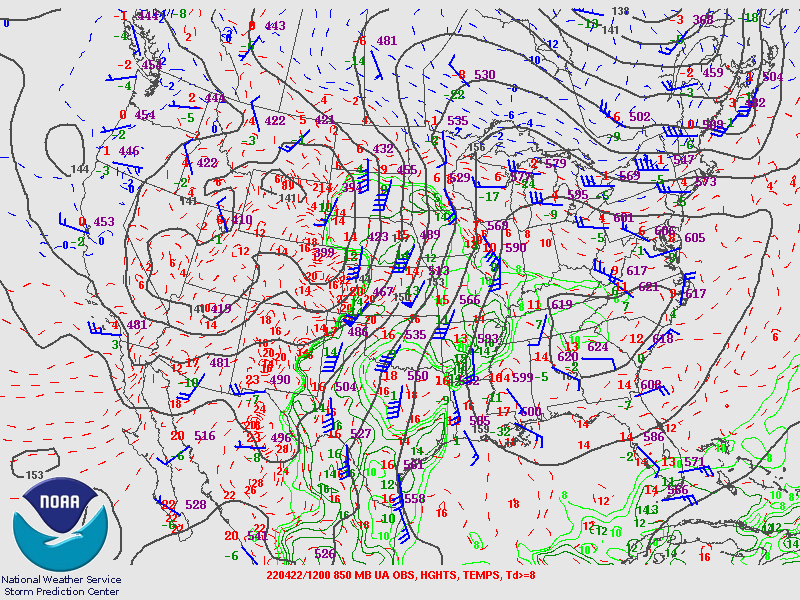
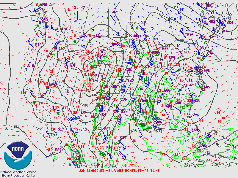
An intense low pressure system brought an extended period of high impact weather to the region throughout the day on April 22nd. This system brought nearly every kind of hazardous weather to the region including numerous wind driven wildfires, widespread damaging winds, blowing dust, severe thunderstorms with large hail and several tornadoes to the Tri-State area. The following image is an analysis of weather balloon data taken at 6 PM MDT on April 22nd at a constant pressure of 850 mb (near the surface in eastern Colorado but rising higher in the atmosphere as elevation decreases). These two images not only show the scale of the system that impacted the region, but also indicates how much the low pressure system intensified through the day. As the storm intensified, winds just off the surface increased to over 70 mph, resulting in widespread damaging wind gusts through the evening.
 |
 |
|
April 22nd 850 MB Observations and Analysis at 6 AM Image from the Storm Prediction Center |
April 22nd 850 MB Observations and Analysis at 6 PM Image from the Storm Prediction Center |
This increase in low level wind speeds not only brought widespread damaging winds, the created a shear profile favorable for tornadoes. As a cold front began to move through the area in the late evening, a line of strong thunderstorms developed in advance of it. While thunderstorms forming into a line often signal that the threat will transition to high winds, the orientation of the front with respect to the strong low level winds created an environment where several short lived tornadoes developed and moved rapidly along the line of storms.
Tornadoes:
|
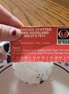
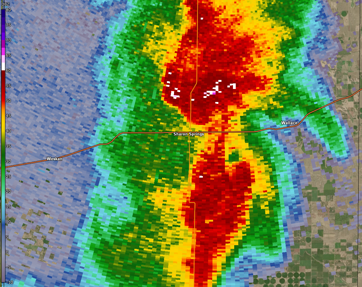
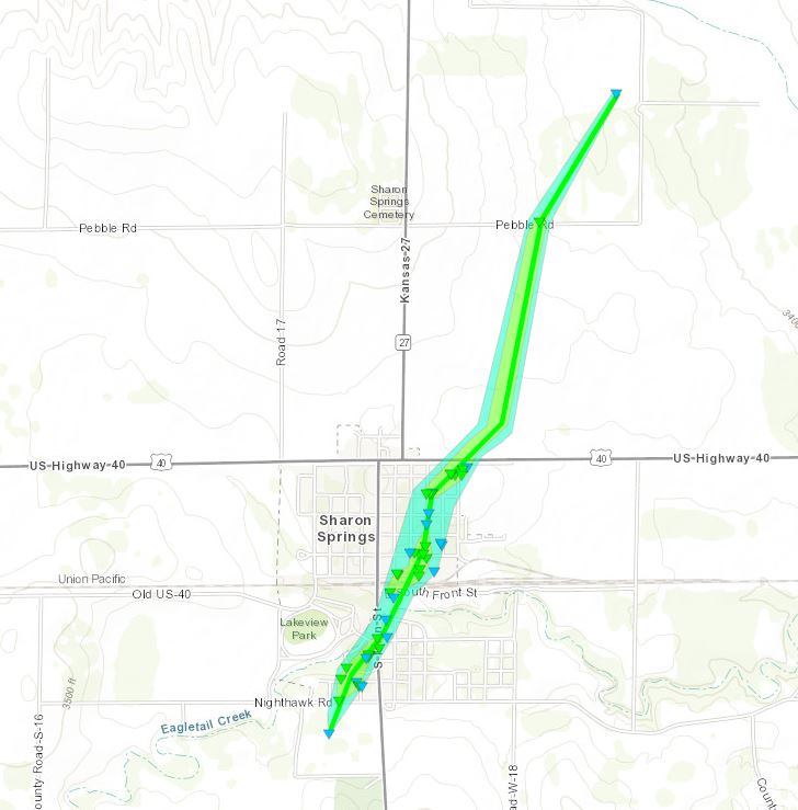
Tornado - Sharon Springs, KS
|
||||||||||||||||
|
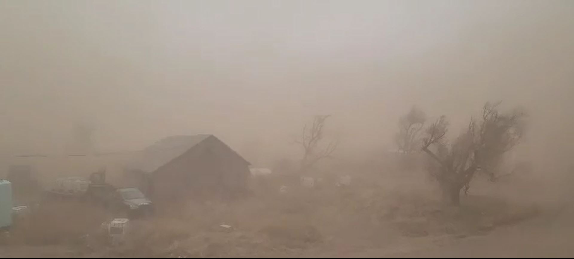
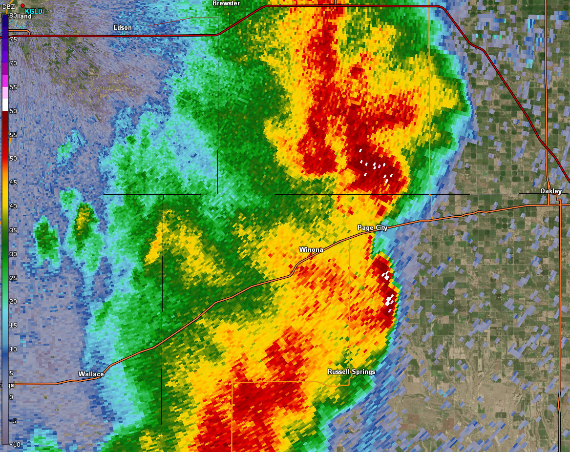
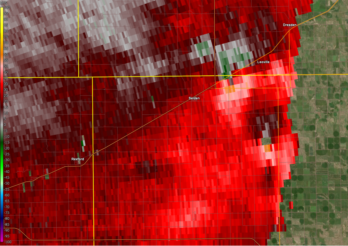
Tornado - NE of Selden, Kansas
|
||||||||||||||||
The Enhanced Fujita (EF) Scale classifies tornadoes into the following categories:
| EF0 Weak 65-85 mph |
EF1 Moderate 86-110 mph |
EF2 Significant 111-135 mph |
EF3 Severe 136-165 mph |
EF4 Extreme 166-200 mph |
EF5 Catastrophic 200+ mph |
 |
|||||
Photos & Video
Header
 |
 |
 |
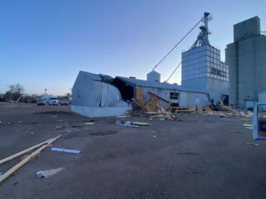 |
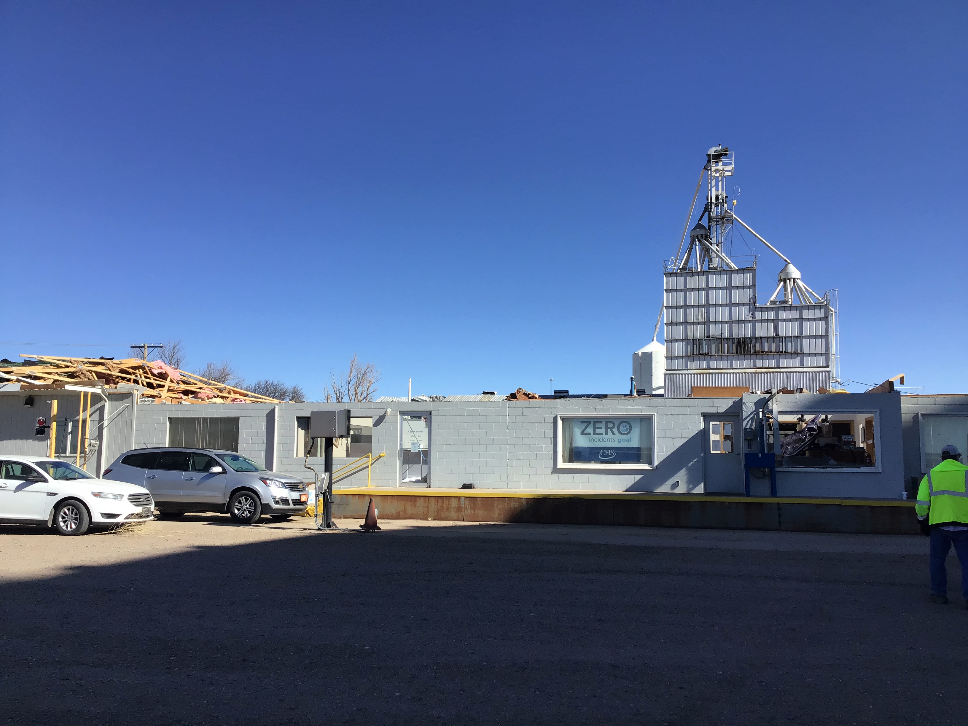
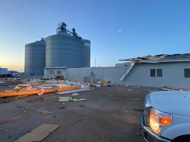
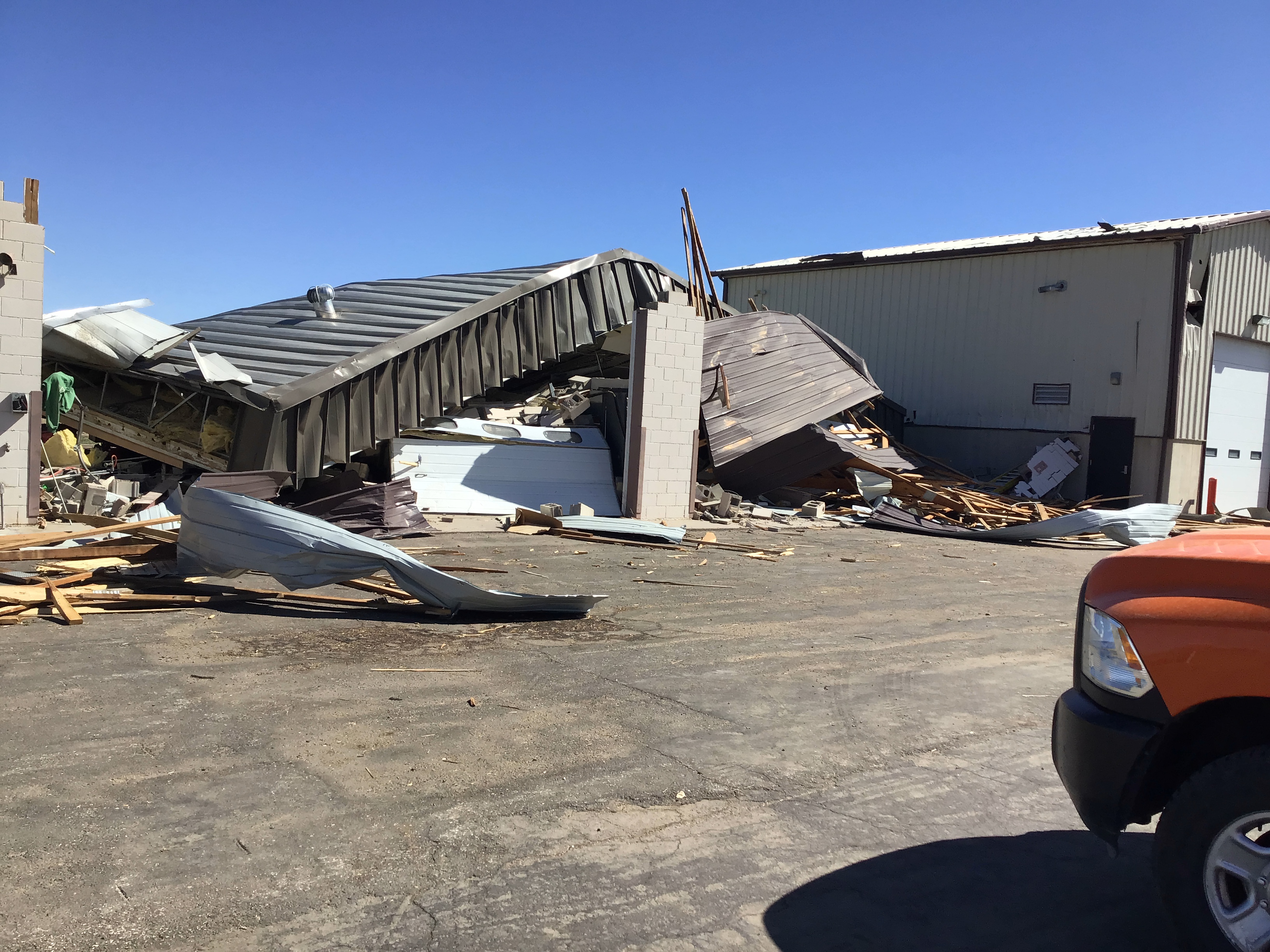
| Sharon Springs CHS Building Damage Credit: NWS Storm Survey |
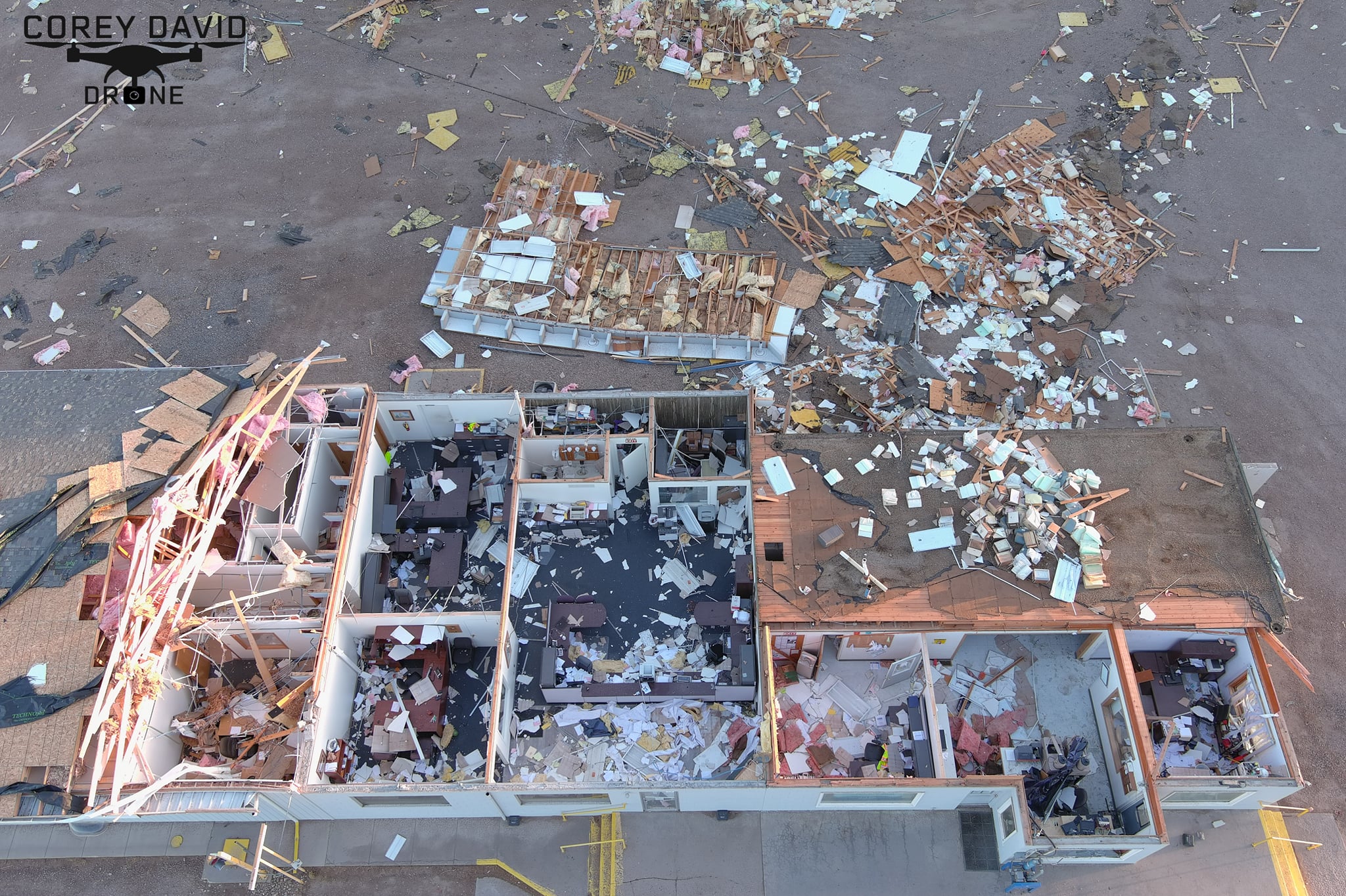
Sharon Springs Building Damage Credit: Corey David |
Sharon Springs Building Damage Credit: Marshall Unruh |
Sharon Springs Building Damage Credit: Marshall Unruh |
 |
 |
 |
 |
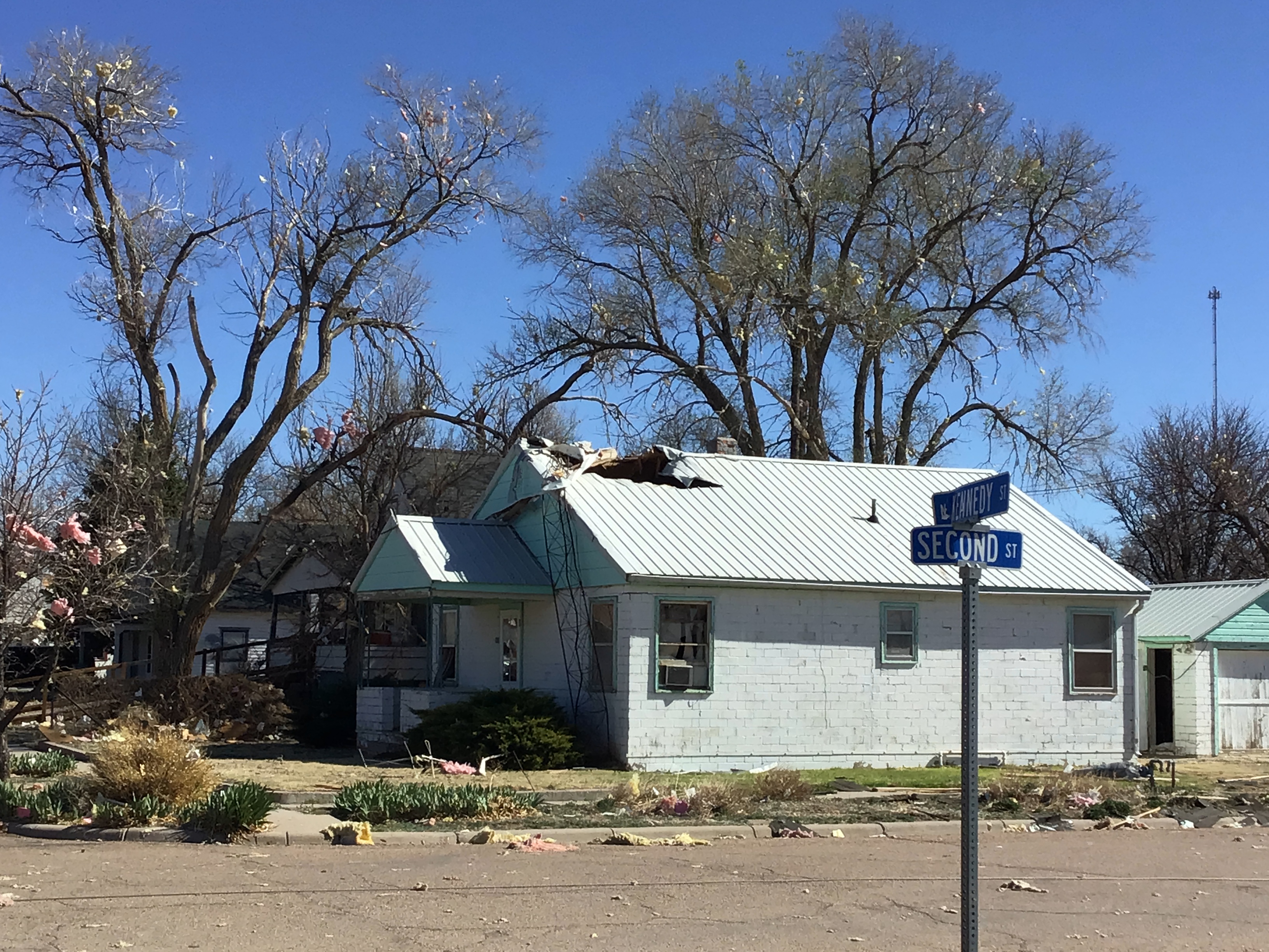
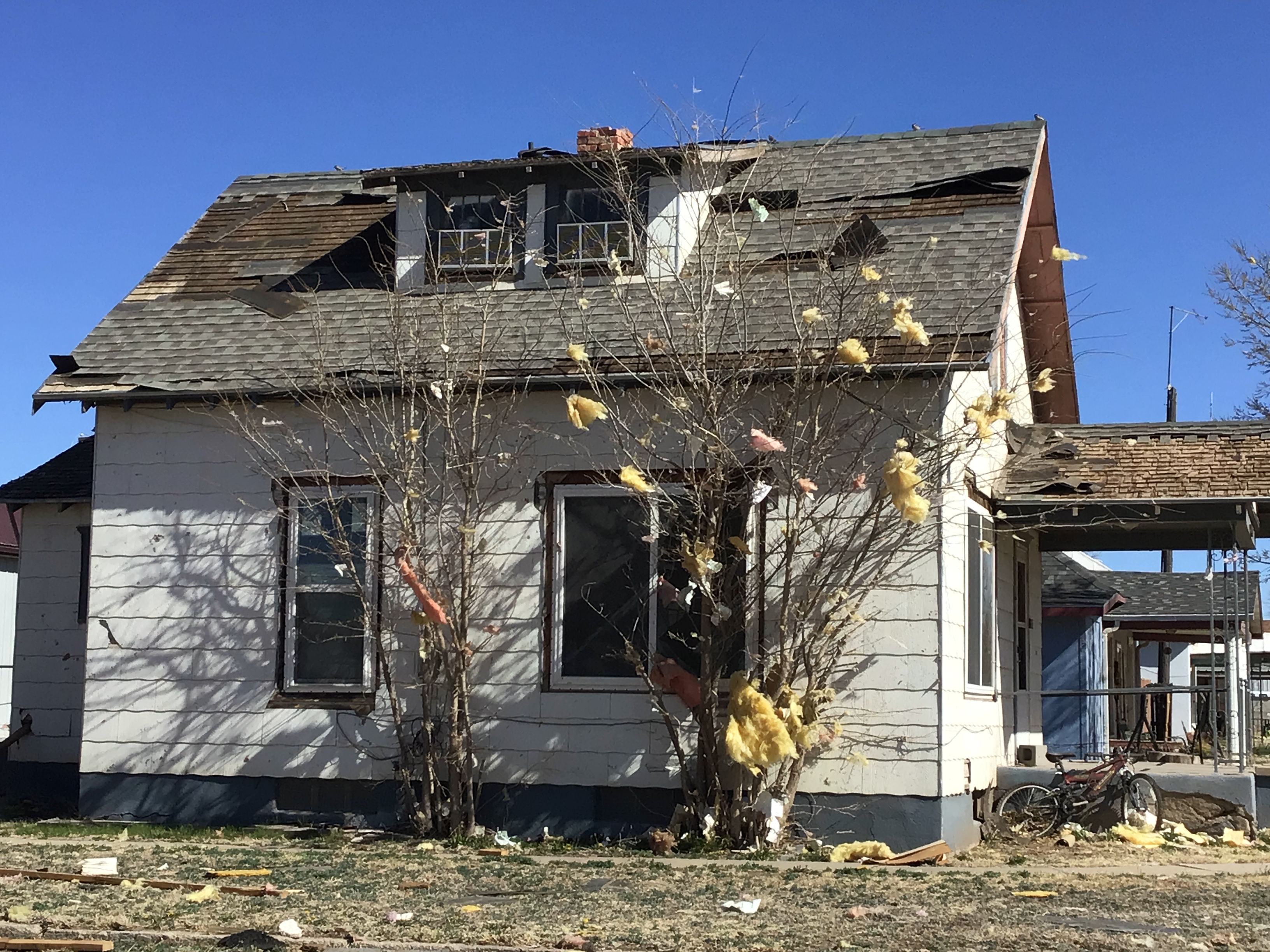
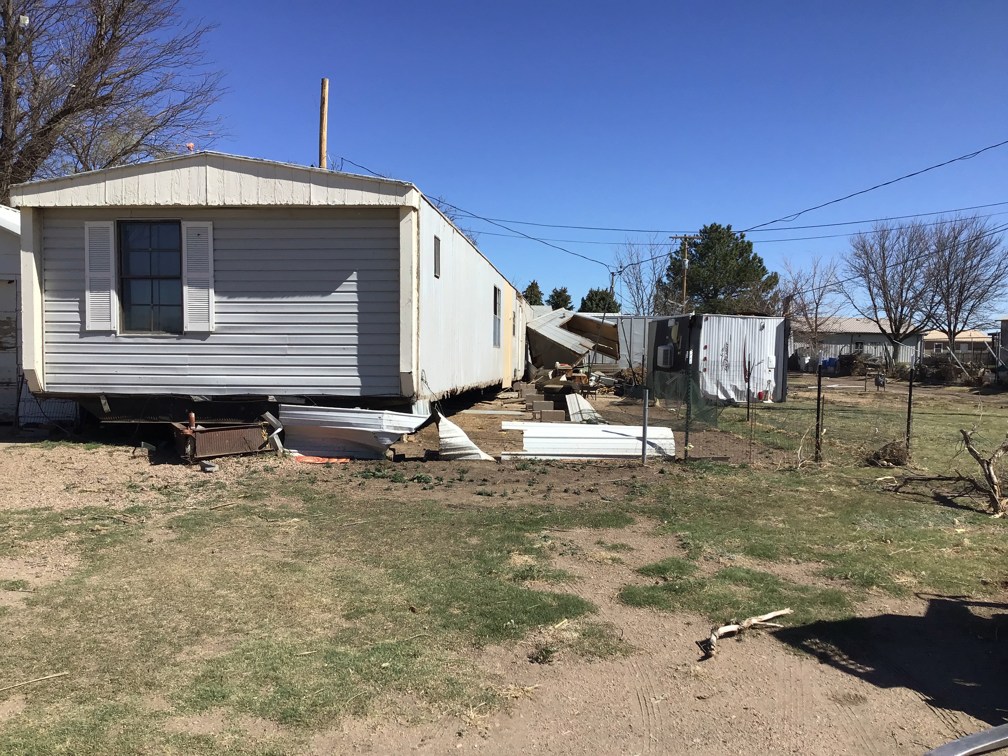
| Sharon Springs House Damage Credit: NWS Storm Survey |
Sharon Springs House Damage Credit: NWS Storm Survey |
Sharon Springs House Damage Credit: NWS Storm Survey |
Sharon Springs KDOT Building Damage Credit: NWS Storm Survey |
 |
 |
 |
 |
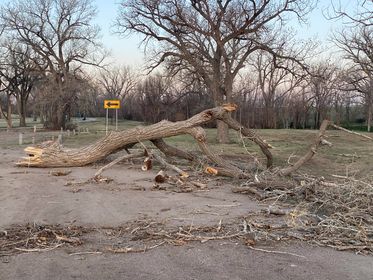
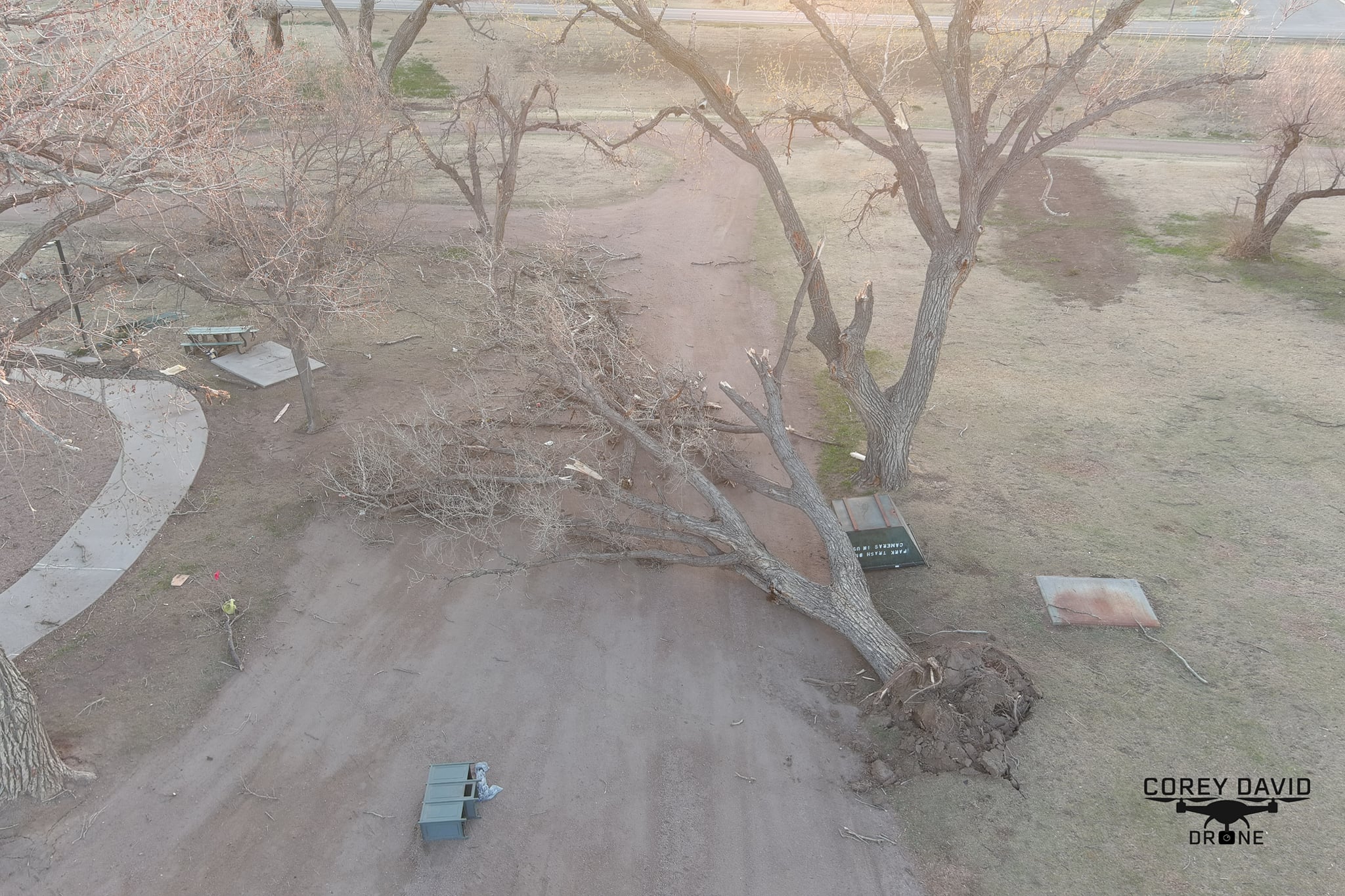
| Sharon Springs Tree Damage Credit: Marshall Unruh |
Sharon Springs Tree Damage Credit: Corey David |
Leoti Hail Credit: Laura Lee Callen |
Dust Storm in Hitchcock County Credit: Ellie Palmer |
Radar
Header
 |
.9.png) |
 |
.8.png) |
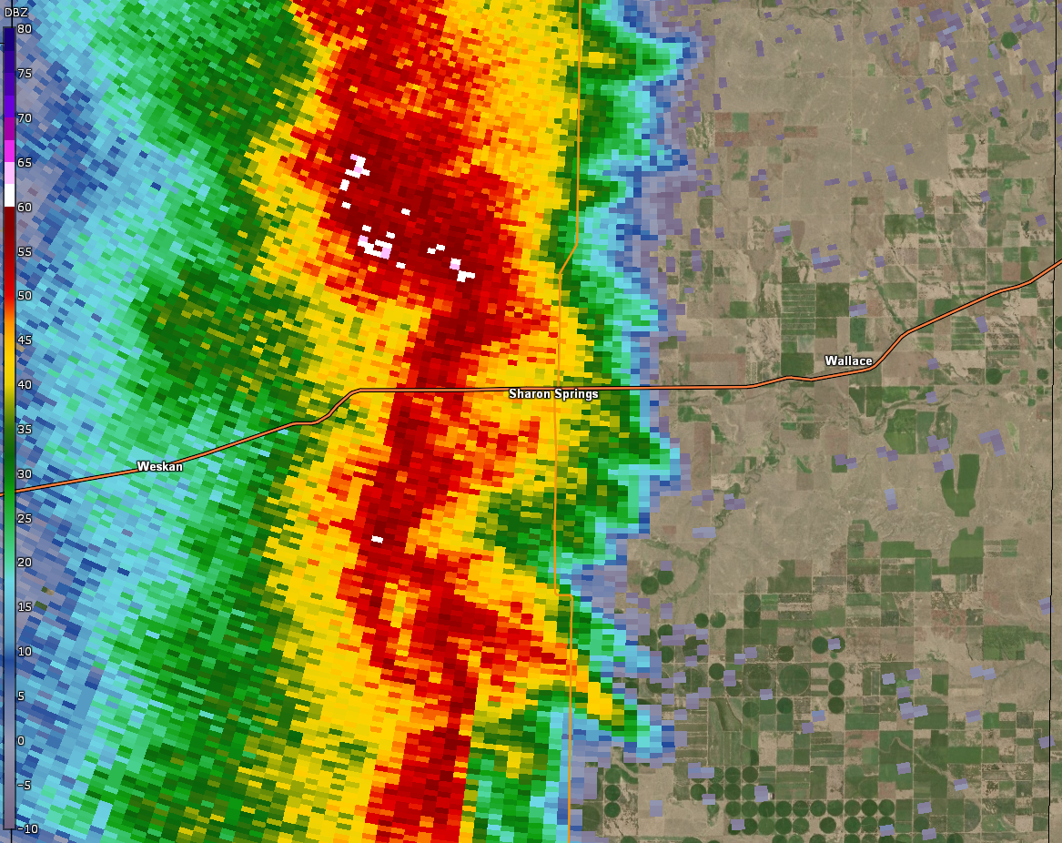
| Base reflectivity at 1034 PM MDT (line approaching Sharon Springs) | Storm Relative Velocity at 1034 PM MDT (line approaching Sharon Springs) | Base reflectivity at 1042 PM MDT (line approaching Sharon Springs) | Storm Relative Velocity at 1042 PM MDT (line approaching Sharon Springs) |
 |
.8.png) |
| Base Reflectivity at 1046 PM MDT (line approaching Sharon Springs) | Storm Relative Velocity at 1046 PM MDT (line approaching Sharon Springs) |
 |
 |
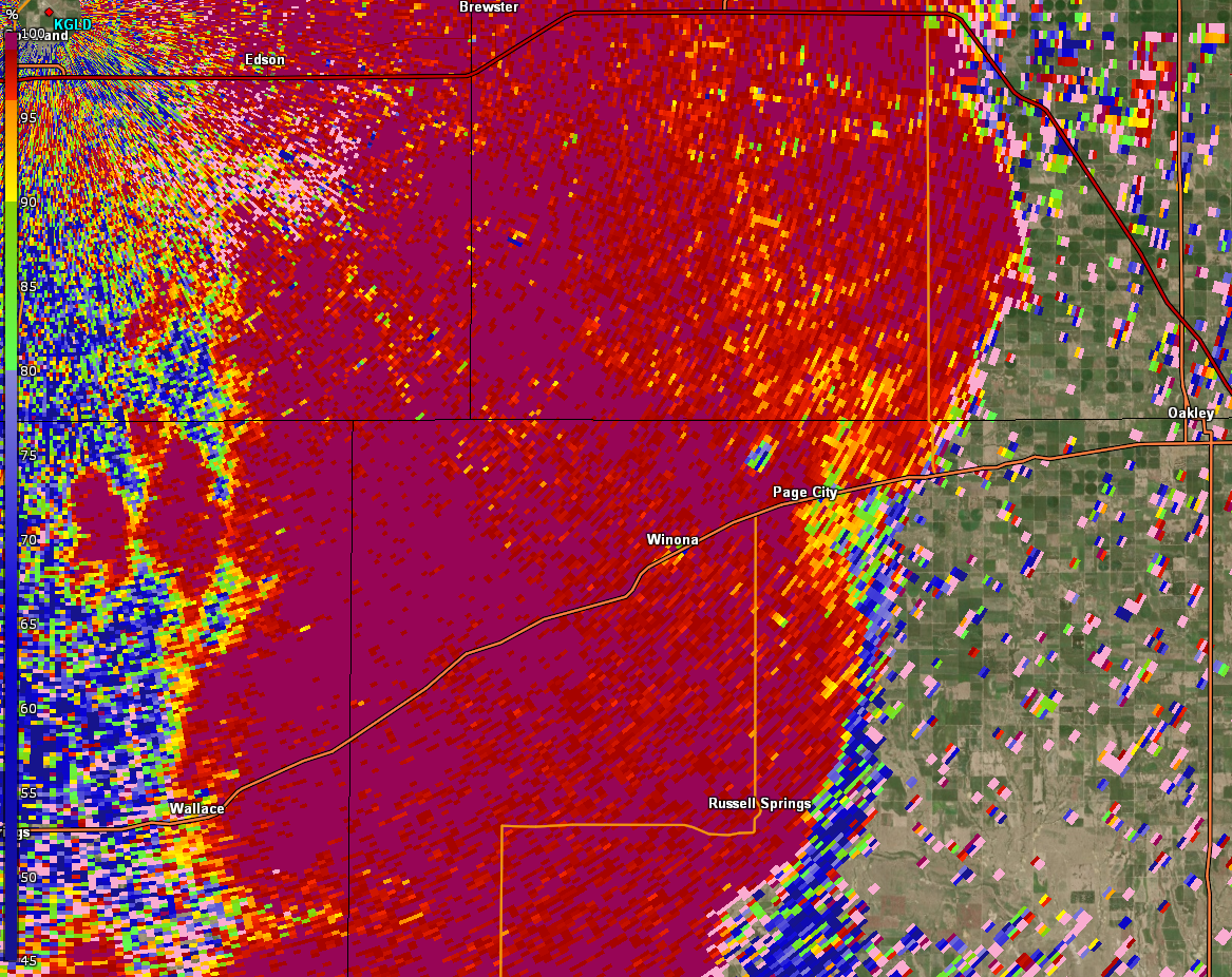 |
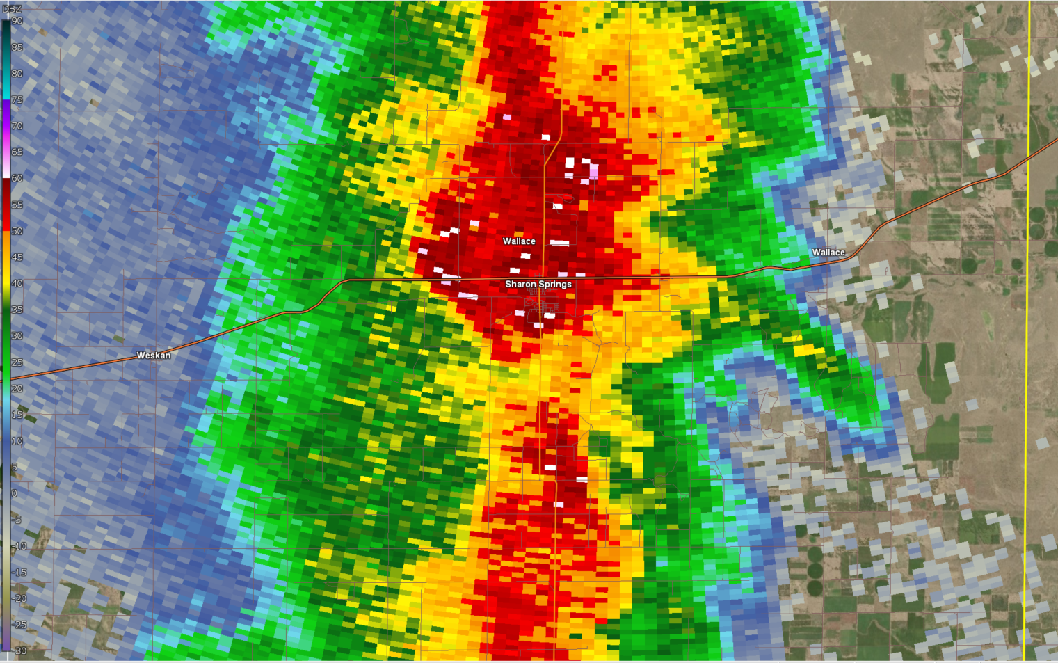
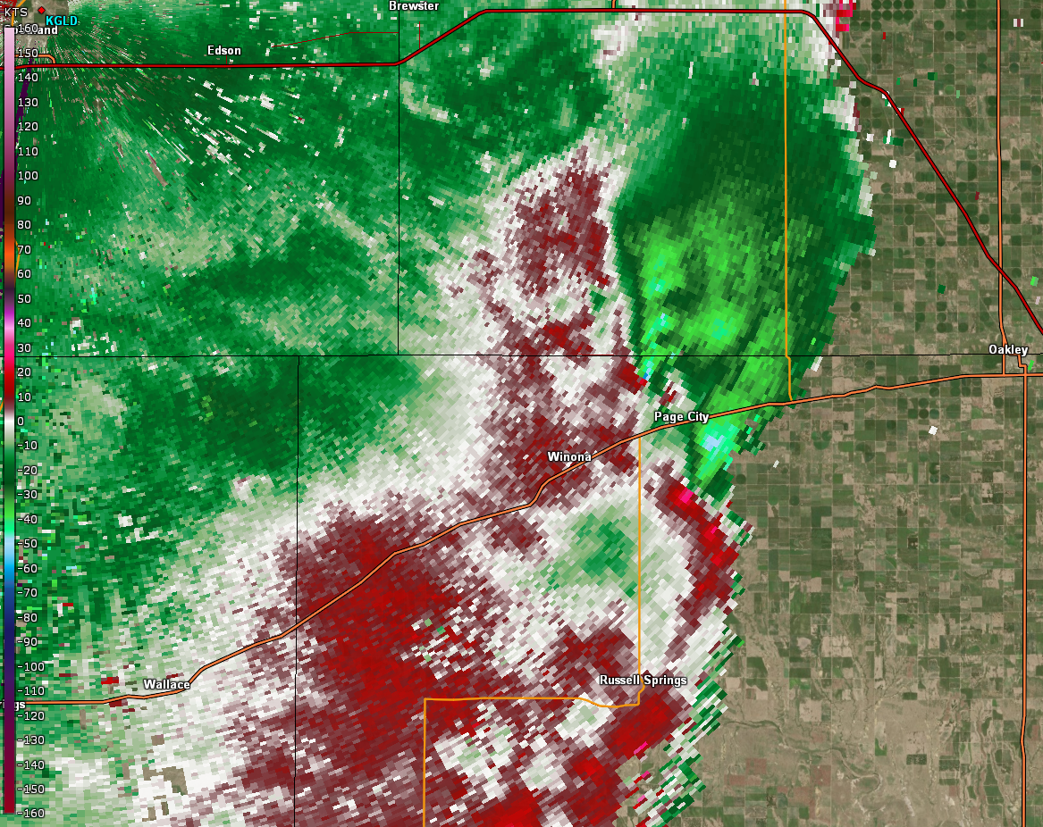
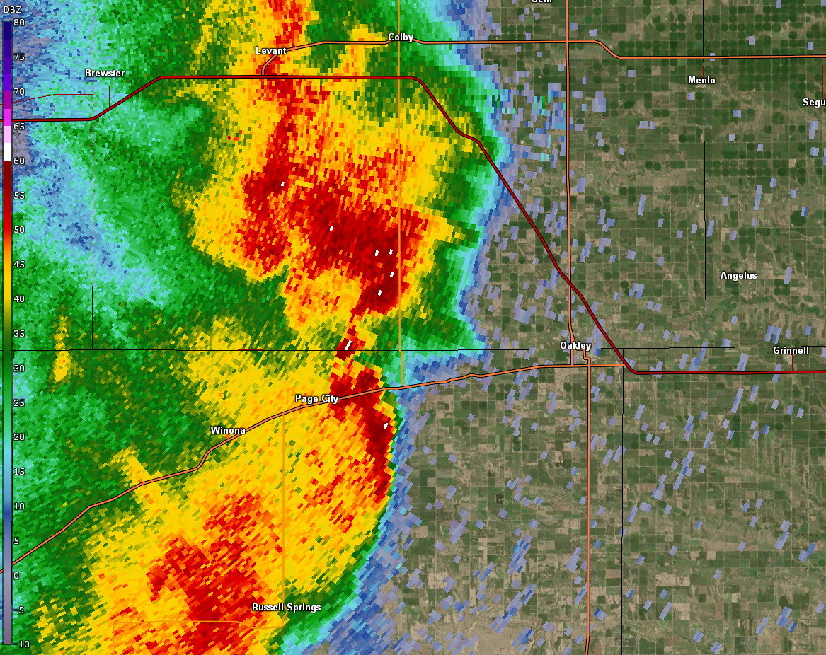
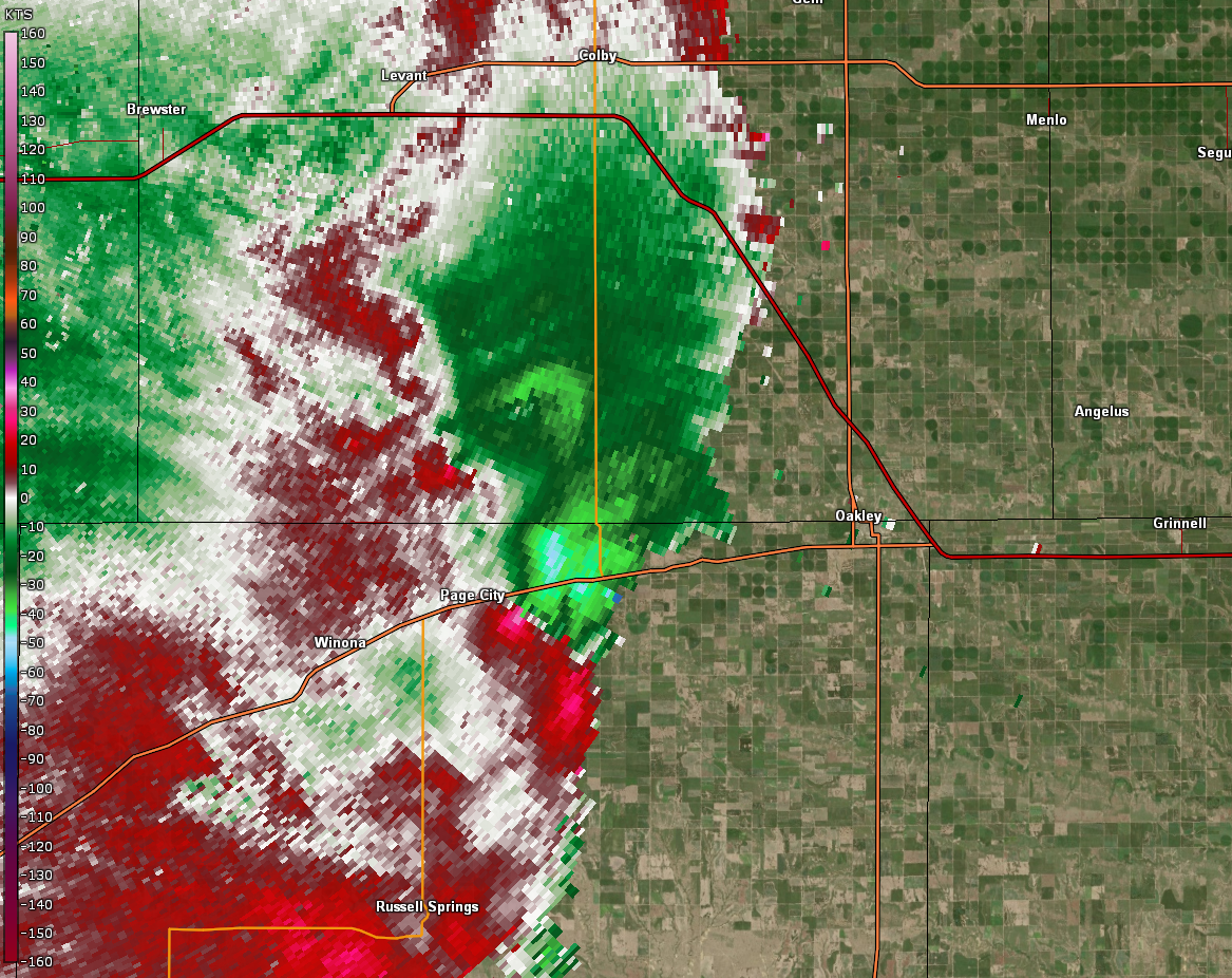
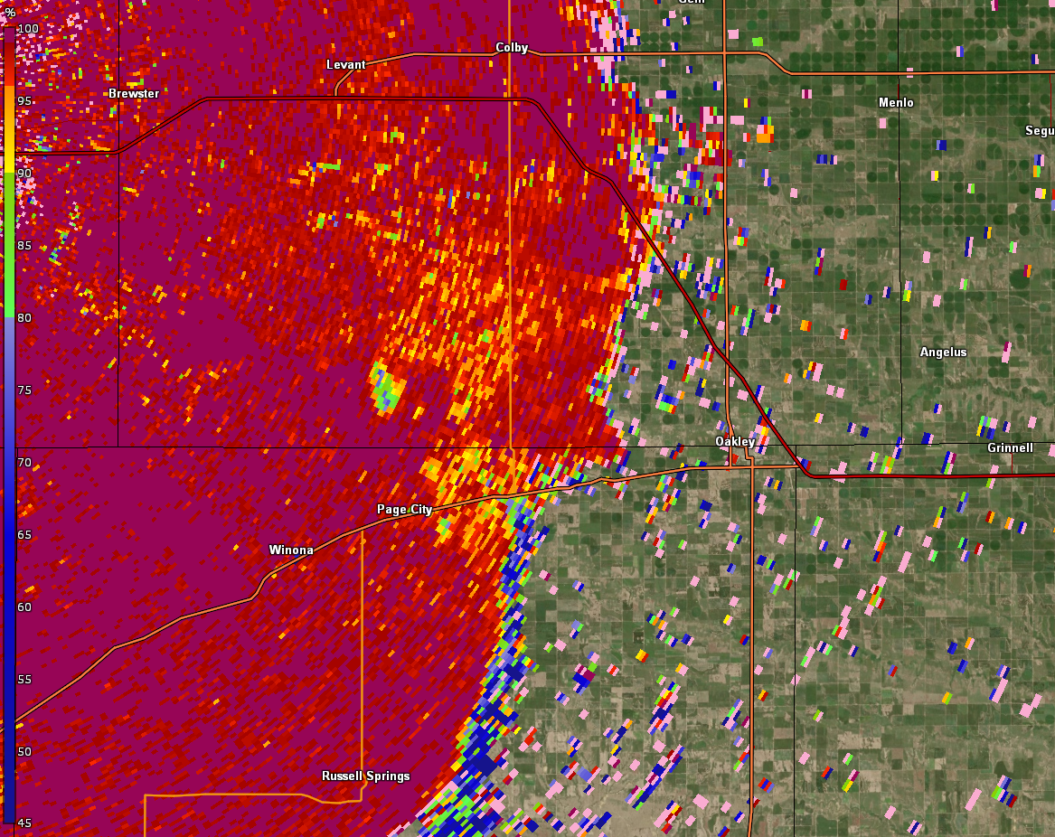
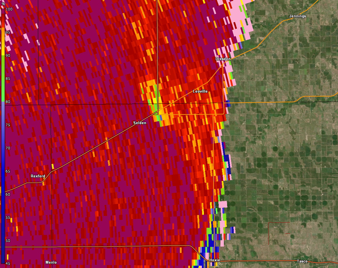
| Base Reflectivity at 1130 PM MDT (Tornado northeast of Winona) | Storm Relative Velocity at 1130 PM MDT (Tornado northeast of Winona a second circulation noted southeast of Page City) | Correlation Coefficient at 1130 PM MDT. Small area of blue values embedded in red area northeast of Winona is in same position as strong circulation. Indicates some form of debris (leaves, dirt, building material) is being lofted). Known as a tornadic debris signature. |
 |
 |
 |
| Base Reflectivity at 1133 PM MDT (Tornado northeast of Winona) | Storm Relative Velocity at 1133 PM MDT , weakening circulation following debris signature in other image. | Correlation Coefficient at 1133 PM MDT. Debris signature moved several miles in just 3 minutes into Thomas county. |
 |
 |
 |
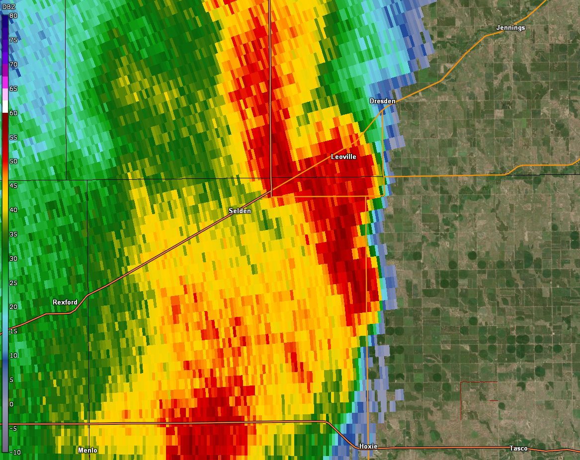
| Base Reflectivity at 1226 AM, tornado to the east of Selden, near the intersection of highway 83 and highway 383 | Storm Relative Velocity at 1226 AM MDT. Potential debris signature noted near the Highway 83/383 junction. | Correlation Coefficient at 1226 AM MDT. Potential debris signature noted near the Highway 83/383 junction. |
Storm Reports
..TIME... ...EVENT... ...CITY LOCATION... ...LAT.LON...
..DATE... ....MAG.... ..COUNTY LOCATION..ST.. ...SOURCE....
..REMARKS..
-----------------------WILDFIRE REPORTS-----------------------------
0329 PM WILDFIRE BENKELMAN 40.05N 101.53W
04/22/2022 DUNDY NE PUBLIC
ONGOING WILDFIRE.
0322 PM WILDFIRE 1 N MCCOOK 40.21N 100.62W
04/22/2022 RED WILLOW NE 911 CALL CENTER
ONGOING WILDFIRE HALF A MILE NORTH OF
MCCOOK.
0650 PM WILDFIRE 7 NNE SAINT FRANCIS 39.87N 101.75W
04/21/2022 CHEYENNE KS 911 CALL CENTER
WILDFIRE REPORTED AND WAS MOSTLY CONTAINED
AS OF 7:06 PM MDT.
---------------THUNDERSTORM WIND GUST REPORTS-----------------------
0642 PM TSTM WND GST 3 N COLBY 39.43N 101.05W
04/22/2022 M72 MPH THOMAS KS AWOS
AWOS STATION KCBK 2 N COLBY.
0635 PM TSTM WND GST 1 SE COLBY 39.38N 101.04W
04/22/2022 M69 MPH THOMAS KS MESONET
0629 PM TSTM WND GST 10 WSW MINGO 39.21N 101.13W
04/22/2022 M62 MPH THOMAS KS MESONET
0726 PM TSTM WND GST 2 E MCCOOK 40.20N 100.58W
04/22/2022 M61 MPH RED WILLOW NE ASOS
ASOS STATION KMCK MCCOOK AIRPORT.
0639 PM TSTM WND GST 5 N COLBY 39.46N 101.05W
04/22/2022 M60 MPH THOMAS KS MESONET
0630 PM TSTM WND GST 8 WSW MINGO 39.23N 101.10W
04/22/2022 M59 MPH THOMAS KS MESONET
0633 PM TSTM WND GST 3 SE OAKLEY 39.10N 100.82W
04/22/2022 M59 MPH LOGAN KS AWOS
AWOS STATION KOEL 2 ESE OAKLEY. 1.75 SM
VISIBILITY.
0713 PM TSTM WND GST 5 WNW THE MONUMENT ROCK 38.80N 100.86W
04/22/2022 M59 MPH LOGAN KS TRAINED SPOTTER
REPEATED 59 MPH GUSTS MEASURED BY HAND
ANEMOMETER.
0135 AM TSTM WND GST 8 N HILL CITY 39.49N 99.85W
04/23/2022 M54 MPH GRAHAM KS MESONET
MESONET STATION K5BCR STOCKTON 8 N.
----------------THUNDERSTORM WIND DAMAGE REPORTS---------------------
0710 PM TSTM WND DMG 5 N BLAKEMAN 39.89N 101.14W
04/22/2022 RAWLINS KS TRAINED SPOTTER
SPOTTER REPORTED SMALL TREE LIMBS DOWN AND
SIDING TORN OFF A BUILDING.
1000 PM TSTM WND DMG BURLINGTON 39.31N 102.27W
04/22/2022 KIT CARSON CO PUBLIC
SOCIAL MEDIA REPORT WITH PICTURE OF A LIVE
TREE DOWNED. TIME ESTIMATED FROM RADAR.
0128 AM TSTM WND DMG HILL CITY 39.37N 99.84W
04/23/2022 GRAHAM KS PUBLIC
SOCIAL MEDIA REPORT IF A FEW SHINGLES BLOWN
OFF OF A ROOF. TIME ESTIMATED BY RADAR.
0107 AM TSTM WND DMG LENORA 39.61N 100.00W
04/23/2022 NORTON KS PUBLIC
SOCIAL MEDIA REPORT WITH PICTURE OF DAMAGE
TO A METAL ROOF. TIME ESTIMATED FROM RADAR.
1126 PM TSTM WND DMG 3 WSW LEVANT 39.37N 101.24W
04/22/2022 THOMAS KS PUBLIC
TWITTER REPORT OF SEMI BLOWN OVER FROM
STRAIGHT LINE WINDS NEAR COUNTRY RD 9. TIME
ESTIMATED FROM RADAR.
1130 PM TSTM WND DMG LEVANT 39.38N 101.20W
04/22/2022 THOMAS KS PUBLIC
SOCIAL MEDIA REPORT WITH PICTURE OF A SHED
DAMAGED IN LEVANT. TIME ESTIMATED BASED ON
RADAR.
0103 AM TSTM WND DMG 7 SSE NEW ALMELO 39.49N 100.07W
04/23/2022 GRAHAM KS PUBLIC
SOCIAL MEDIA REPORT WITH PICTURES OF BROKEN
POWER POLES AND DAMAGE TO A SMALL BARN. TIME
ESTIMATED FROM RADAR.
1245 AM TSTM WND DMG NORCATUR 39.84N 100.19W
04/23/2022 DECATUR KS PUBLIC
SOCIAL MEDIA REPORT WITH PICTURE OF DAMAGE
TO THE NORCATUR SCHOOL ROOF. TIME ESTIMATED
FROM RADAR.
1248 AM TSTM WND DMG 2 N NORCATUR 39.86N 100.19W
04/23/2022 DECATUR KS PUBLIC
SOCIAL MEDIA REPORT OFF WIND DAMAGE TO A
METAL SHED. TIME ESTIMATED FROM RADAR.
1225 AM TSTM WND DMG 1 SSW OBERLIN 39.81N 100.53W
04/23/2022 DECATUR KS PUBLIC
SOCIAL MEDIA REPORT WITH PICTURE OF DAMAGE
TO A ROOF ON AN OUTER BUILDING. TIME
ESTIMATED FROM RADAR.
1230 AM TSTM WND DMG OBERLIN 39.83N 100.53W
04/23/2022 DECATUR KS PUBLIC
SOCIAL MEDIA REPORT WITH PICTURE OF LIVE
TREE SNAPPED. ESTIMATED 6 INCHES IN
DIAMETER. TIME ESTIMATED FROM RADAR.
1200 AM TSTM WND DMG REXFORD 39.47N 100.75W
04/23/2022 THOMAS KS PUBLIC
SOCIAL MEDIA REPORT WITH PICTURE OF DAMAGE
TO A ROOF OF AN OUTER BUILDING. TIME
ESTIMATED FROM RADAR.
1225 AM TSTM WND DMG 1 E SELDEN 39.54N 100.54W
04/22/2022 SHERIDAN KS PUBLIC
DELAYED REPORT VIA SOCIAL MEDIA. PIVOT
IRRIGATION SYSTEM KNOCKED DOWN BY POSSIBLE
TORNADO. TIME BASED OFF RADAR.
1222 PM TSTM WND DMG 2 S SELDEN 39.51N 100.56W
04/23/2022 SHERIDAN KS PUBLIC
DELAYED REPORT VIA SOCIAL MEDIA. THREE BLOWN
OVER PIVOT IRRIGATION SYSTEMS ON EITHER SIDE
OF COUNTY ROAD 110 N AND WEST OF 60 W.
DAMAGE POSSIBLY BY A TORNADO. TIME ESTIMATED
BY RADAR.
1130 PM TSTM WND DMG 8 S SELKIRK 38.36N 101.51W
04/22/2022 WICHITA KS PUBLIC
SOCIAL MEDIA REPORT WITH PICTURES OF DAMAGE
TO A FARM VEHICLE AND A BARN WALL. TIME
ESTIMATED FROM RADAR.
-----------------------TORNADO REPORTS------------------------------
1241 AM TORNADO 5 NNE GRAINFIELD 39.18N 100.42W
04/23/2022 SHERIDAN KS STORM CHASER
TIME AND LOCATION ESTIMATED.
1148 PM TORNADO 1 WSW MINGO 39.27N 100.98W
04/22/2022 THOMAS KS NWS EMPLOYEE
TORNADO DEBRIS SIGNATURE SEEN ON RADAR,
POTENTIAL TORNADO.
1225 AM TORNADO 3 ENE SELDEN 39.56N 100.52W
04/23/2022 SHERIDAN KS LAW ENFORCEMENT
REPORT FROM EM RELAYED VIA DISPATCH. DAMAGE
LOCATED NEAR THE 83/383 JUNCTION. POWER
FLASHES NOTED AS WELL AS A DAMAGED RAILROAD
CROSSING ASSEMBLY. OTHER DAMAGE POTENTIALLY
NEAR LEOVILLE. RADAR CONFIRMED TDS SIGNATURE
AT THIS TIME AND LOCATION.
1050 PM TORNADO SHARON SPRINGS 38.89N 101.75W
04/22/2022 WALLACE KS LAW ENFORCEMENT
MULTIPLE REPORTS OF POWERLINES DOWN AND
DEBRIS IN SHARON SPRINGS.
1130 PM TORNADO 5 NE WINONA 39.12N 101.18W
04/22/2022 LOGAN KS NWS EMPLOYEE
TORNADO DEBRIS SIGNATURE OBSERVED ON RADAR
AT LOCATION. THIS REPORT CORRECTS THE
PREVIOUS REPORT OF A TORNADO IN WINONA.
1146 PM TORNADO 10 NNW WINONA 39.20N 101.33W
04/22/2022 THOMAS KS PUBLIC
RECEIVED A REPORT OF POSSIBLE TORNADO DAMAGE
AT LOCATION. AREA CORRESPONDS TO A TDS AND
CIRCULATION ON RADAR.
--------------NON-THUNDERSTORM WIND GUST REPORTS--------------------
0719 PM NON-TSTM WND GST 3 WNW TRENTON 40.19N 101.07W
04/22/2022 M82 MPH HITCHCOCK NE MESONET
0815 PM NON-TSTM WND GST 4 NNW VERNON 39.98N 102.30W
04/22/2022 M75 MPH YUMA CO MESONET
0344 PM NON-TSTM WND GST 5 S BURLINGTON 39.23N 102.28W
04/22/2022 M74 MPH KIT CARSON CO ASOS
ASOS STATION KITR BURLINGTON CO AIRPORT. 4
SM VISIBILITY DUE TO BLOWING DUST.
0540 PM NON-TSTM WND GST 1 WNW COLBY 39.39N 101.07W
04/22/2022 M74 MPH THOMAS KS MESONET
KANSAS MESONET.
0640 PM NON-TSTM WND GST 1 NNE GOODLAND 39.37N 101.70W
04/22/2022 M74 MPH SHERMAN KS ASOS
ASOS STATION KGLD GOODLAND. 1 SM VISIBILITY
DUE TO BLOWING DUST.
0451 PM NON-TSTM WND GST 4 NNW VERNON 39.98N 102.30W
04/22/2022 M73 MPH YUMA CO MESONET
0753 PM NON-TSTM WND GST 1 E HILL CITY 39.37N 99.83W
04/22/2022 M72 MPH GRAHAM KS ASOS
ASOS STATION KHLC HILL CITY. VISIBILITY
REDUCED TO 4SM DUE TO BLOWING DUST.
0510 PM NON-TSTM WND GST 3 WSW RUSSELL SPRINGS 38.89N 101.22W
04/22/2022 M71 MPH LOGAN KS MESONET
KANSAS MESONET.
0422 PM NON-TSTM WND GST 2 S WRAY 40.05N 102.23W
04/22/2022 M71 MPH YUMA CO PUBLIC
0626 PM NON-TSTM WND GST 1 NNE GOODLAND 39.37N 101.70W
04/22/2022 M70 MPH SHERMAN KS ASOS
ASOS STATION KGLD GOODLAND. 5 SM VISIBILITY
DUE TO BLOWING DUST.
0206 PM NON-TSTM WND GST 5 S BURLINGTON 39.23N 102.28W
04/22/2022 M69 MPH KIT CARSON CO ASOS
ASOS STATION KITR BURLINGTON CO AIRPORT.
0659 PM NON-TSTM WND GST 5 S BURLINGTON 39.23N 102.28W
04/22/2022 M68 MPH KIT CARSON CO ASOS
ASOS STATION KITR BURLINGTON CO AIRPORT. 2
SM VISIBILITY DUE TO BLOWING DUST.
0853 PM NON-TSTM WND GST 5 S BURLINGTON 39.23N 102.28W
04/22/2022 M68 MPH KIT CARSON CO ASOS
ASOS STATION KITR BURLINGTON CO AIRPORT.
VISIBILITY REDUCED TO 5SM IN BLOWING DUST.
0610 PM NON-TSTM WND GST 4 N LUDELL 39.91N 100.96W
04/22/2022 M68 MPH RAWLINS KS MESONET
KANSAS MESONET.
0307 PM NON-TSTM WND GST 5 S BURLINGTON 39.23N 102.28W
04/22/2022 M67 MPH KIT CARSON CO ASOS
ASOS STATION KITR BURLINGTON CO AIRPORT. 5
SM VISIBILITY DUE TO BLOWING DUST.
0415 PM NON-TSTM WND GST 5 NNW HEARTSTRONG 40.01N 102.63W
04/22/2022 M67 MPH YUMA CO MESONET
0645 PM NON-TSTM WND GST 1 E HILL CITY 39.37N 99.83W
04/22/2022 M67 MPH GRAHAM KS ASOS
ASOS STATION KHLC HILL CITY. VISIBILITY
REDUCED TO 6SM DUE TO BLOWING DUST.
0700 PM NON-TSTM WND GST 2 E MCCOOK 40.20N 100.58W
04/22/2022 M67 MPH RED WILLOW NE ASOS
ASOS STATION KMCK MCCOOK AIRPORT.
0706 PM NON-TSTM WND GST 2 N ATWOOD 39.84N 101.04W
04/22/2022 M66 MPH RAWLINS KS AWOS
0245 PM NON-TSTM WND GST 13 NNW RULETON 39.52N 101.93W
04/22/2022 M66 MPH SHERMAN KS MESONET
MESONET STATION FW1147 16 NW GOODLAND.
0915 PM NON-TSTM WND GST 2 NW WRAY 40.10N 102.25W
04/22/2022 M66 MPH YUMA CO AWOS
AWOS STATION K2V5 2 NW WRAY. VISIBILITY
REDUCED TO 5SM DUE TO BLOWING DUST.
0548 PM NON-TSTM WND GST 1 NNE GOODLAND 39.37N 101.70W
04/22/2022 M65 MPH SHERMAN KS ASOS
ASOS STATION KGLD GOODLAND. 5 SM VISIBILITY
DUE TO BLOWING DUST.
0709 PM NON-TSTM WND GST 6 NW MCDONALD 39.85N 101.43W
04/22/2022 M64 MPH CHEYENNE KS MESONET
0855 PM NON-TSTM WND GST SAINT FRANCIS 39.77N 101.80W
04/22/2022 M64 MPH CHEYENNE KS AWOS
AWOS STATION KSYF ST. FRANCIS CITY.
VISIBILITY REDUCED TO 4SM DUE TO BLOWING
DUST.
1250 PM NON-TSTM WND GST 2 SW FIRSTVIEW 38.80N 102.55W
04/22/2022 M63 MPH CHEYENNE CO MESONET
0414 PM NON-TSTM WND GST 8 N MARIENTHAL 38.60N 101.23W
04/22/2022 M63 MPH WICHITA KS MESONET
0129 AM NON-TSTM WND GST 2 E MCCOOK 40.20N 100.58W
04/23/2022 M63 MPH RED WILLOW NE ASOS
ASOS STATION KMCK MCCOOK AIRPORT.
0343 PM NON-TSTM WND GST CAMPUS 39.13N 100.74W
04/22/2022 M62 MPH GOVE KS MESONET
0650 PM NON-TSTM WND GST 1 E HILL CITY 39.37N 99.83W
04/22/2022 M62 MPH GRAHAM KS ASOS
ASOS STATION KHLC HILL CITY. 7 SM VISIBILITY
DUE TO BLOWING DUST.
0331 PM NON-TSTM WND GST JOES 39.65N 102.68W
04/22/2022 M62 MPH YUMA CO MESONET
1241 PM NON-TSTM WND GST 9 WSW WINONA 39.00N 101.39W
04/22/2022 M62 MPH LOGAN KS MESONET
MESONET STATION UP840 9.0 W WINONA (UPR).
0431 PM NON-TSTM WND GST 4 ENE YUMA 40.14N 102.65W
04/22/2022 M62 MPH YUMA CO MESONET
1234 AM NON-TSTM WND GST 5 S BURLINGTON 39.23N 102.28W
04/22/2022 M61 MPH KIT CARSON CO ASOS
ASOS STATION KITR BURLINGTON CO AIRPORT.
0240 PM NON-TSTM WND GST 2 E MCCOOK 40.20N 100.58W
04/22/2022 M61 MPH RED WILLOW NE ASOS
ASOS STATION KMCK MCCOOK AIRPORT. 5 SM
VISIBILITY DUE TO BLOWING DUST.
0203 PM NON-TSTM WND GST 9 SSE SHARON SPRINGS 38.77N 101.68W
04/22/2022 M61 MPH WALLACE KS MESONET
MESONET STATION CW6099 9 SSE SHARON SPRINGS.
0240 PM NON-TSTM WND GST 3 SE BEARDSLEY 39.78N 101.19W
04/22/2022 M61 MPH RAWLINS KS MESONET
MESONET STATION K5ADT US-36 - 9 MI. W OF
ATWOOD.
0349 PM NON-TSTM WND GST BURLINGTON 39.30N 102.27W
04/22/2022 M60 MPH KIT CARSON CO MESONET
0845 PM NON-TSTM WND GST HALE 39.63N 102.12W
04/22/2022 M60 MPH YUMA CO MESONET
0149 PM NON-TSTM WND GST LEOTI 38.48N 101.36W
04/22/2022 M60 MPH WICHITA KS MESONET
1245 PM NON-TSTM WND GST 4 N LUDELL 39.91N 100.96W
04/22/2022 M60 MPH RAWLINS KS MESONET
KANSAS MESONET.
0320 PM NON-TSTM WND GST 2 E MCCOOK 40.20N 100.58W
04/22/2022 M60 MPH RED WILLOW NE ASOS
ASOS STATION KMCK MCCOOK AIRPORT. 4 SM DUE
TO BLOWING DUST.
0655 PM NON-TSTM WND GST SAINT FRANCIS 39.77N 101.80W
04/22/2022 M60 MPH CHEYENNE KS AWOS
AWOS STATION KSYF ST. FRANCIS CITY. 1.75 SM
VISIBILITY DUE TO BLOWING DUST.
1250 PM NON-TSTM WND GST 4 W WALLACE 38.92N 101.67W
04/22/2022 M60 MPH WALLACE KS MESONET
MESONET STATION K5WLC US-40 - 2 MI. W OF
WALLACE.
0724 PM NON-TSTM WND GST 8 N BENKELMAN 40.16N 101.53W
04/22/2022 M59 MPH DUNDY NE MESONET
0224 PM NON-TSTM WND GST 8 SSE BURLINGTON 39.20N 102.20W
04/22/2022 M59 MPH KIT CARSON CO MESONET
0406 PM NON-TSTM WND GST 1 SE COLBY 39.38N 101.04W
04/22/2022 M59 MPH THOMAS KS MESONET
0128 PM NON-TSTM WND GST 1 NNE GOODLAND 39.37N 101.70W
04/22/2022 M59 MPH SHERMAN KS ASOS
ASOS STATION KGLD GOODLAND. 3 SM VISIBILITY
DUE TO BLOWING DUST.
0200 PM NON-TSTM WND GST 1 NNE GOODLAND 39.37N 101.70W
04/22/2022 M59 MPH SHERMAN KS ASOS
ASOS STATION KGLD GOODLAND. 3SM VISIBILITY
DUE TO BLOWING DUST.
0458 PM NON-TSTM WND GST GOVE 38.96N 100.49W
04/22/2022 M59 MPH GOVE KS MESONET
0405 PM NON-TSTM WND GST KANORADO 39.34N 102.04W
04/22/2022 M59 MPH SHERMAN KS MESONET
0221 PM NON-TSTM WND GST 2 E MCCOOK 40.20N 100.58W
04/22/2022 M59 MPH RED WILLOW NE ASOS
ASOS STATION KMCK MCCOOK AIRPORT. 6 SM
VISIBILITY DUE TO BLOWING DUST.
0139 PM NON-TSTM WND GST 3 SSW RULETON 39.30N 101.90W
04/22/2022 M59 MPH SHERMAN KS MESONET
0213 PM NON-TSTM WND GST 12 WNW SAINT FRANCIS 39.83N 102.01W
04/22/2022 M59 MPH CHEYENNE KS MESONET
0239 PM NON-TSTM WND GST 5 S SELDEN 39.47N 100.57W
04/22/2022 M59 MPH SHERIDAN KS MESONET
0154 PM NON-TSTM WND GST 3 WNW TRENTON 40.19N 101.07W
04/22/2022 M59 MPH HITCHCOCK NE MESONET
0215 PM NON-TSTM WND GST 8 NNE TRIBUNE 38.57N 101.70W
04/22/2022 M59 MPH GREELEY KS MESONET
0254 PM NON-TSTM WND GST 5 S TRIBUNE 38.39N 101.74W
04/22/2022 M59 MPH GREELEY KS MESONET
MESONET STATION DW9439 TRIBUNE.
0329 PM NON-TSTM WND GST 6 E TRIBUNE 38.47N 101.65W
04/22/2022 M59 MPH GREELEY KS MESONET
0535 PM NON-TSTM WND GST 2 NW WRAY 40.10N 102.25W
04/22/2022 M59 MPH YUMA CO AWOS
AWOS STATION K2V5 2 NW WRAY. VISIBILITY
REDUCED TO 3SM DUE TO BLOWING DUST.
0703 PM NON-TSTM WND GST 3 W BIRD CITY 39.76N 101.59W
04/22/2022 M58 MPH CHEYENNE KS MESONET
MESONET STATION DW4654 BIRD CITY.
0829 PM NON-TSTM WND GST 1 ENE BURLINGTON 39.31N 102.25W
04/22/2022 M58 MPH KIT CARSON CO MESONET
1231 AM NON-TSTM WND GST 1 NNE GOODLAND 39.37N 101.70W
04/22/2022 M58 MPH SHERMAN KS ASOS
ASOS STATION KGLD GOODLAND. 6SM VISIBILITY
DUE TO BLOWING DUST.
1236 AM NON-TSTM WND GST 1 NNE GOODLAND 39.37N 101.70W
04/22/2022 M58 MPH SHERMAN KS ASOS
ASOS STATION KGLD GOODLAND. 4 SM VISIBILITY
DUE TO BLOWING DUST.
0130 PM NON-TSTM WND GST 2 W EDSON 39.33N 101.58W
04/22/2022 M58 MPH SHERMAN KS MESONET
MESONET STATION K5ED7 I-70 - EDSON
INTERCHANGE.
0305 PM NON-TSTM WND GST 2 E LEOTI 38.49N 101.33W
04/22/2022 M58 MPH WICHITA KS MESONET
KANSAS MESONET.
0409 PM NON-TSTM WND GST LEOTI 38.49N 101.36W
04/22/2022 E58 MPH WICHITA KS PUBLIC
A MEASURED 58MPH WIND GUST JUST NORTH OF
LEOTI.
0204 PM NON-TSTM WND GST 8 N MARIENTHAL 38.60N 101.23W
04/22/2022 M58 MPH WICHITA KS MESONET
0550 PM NON-TSTM WND GST 5 WNW NORTON 39.87N 99.97W
04/22/2022 M58 MPH NORTON KS MESONET
KANSAS MESONET.
0435 PM NON-TSTM WND GST 3 SE OAKLEY 39.10N 100.82W
04/22/2022 M58 MPH LOGAN KS AWOS
AWOS STATION KOEL 2 ESE OAKLEY. 5 SM
VISIBILITY DUE TO BLOWING DUST.
0625 PM NON-TSTM WND GST 7 NE OBERLIN 39.90N 100.44W
04/22/2022 M58 MPH DECATUR KS MESONET
KANSAS MESONET.
0623 PM NON-TSTM WND GST QUINTER 39.07N 100.23W
04/22/2022 M58 MPH GOVE KS MESONET
0120 PM NON-TSTM WND GST 3 WSW RUSSELL SPRINGS 38.89N 101.22W
04/22/2022 M58 MPH LOGAN KS MESONET
KANSAS MESONET.
0455 PM NON-TSTM WND GST SAINT FRANCIS 39.77N 101.80W
04/22/2022 M58 MPH CHEYENNE KS AWOS
AWOS STATION KSYF ST. FRANCIS CITY. 4 SM
VISIBILITY DUE TO BLOWING DUST.
0100 PM NON-TSTM WND GST 1 S TRIBUNE 38.46N 101.75W
04/22/2022 M58 MPH GREELEY KS PUBLIC
KTRB AWOS. 2.5 SM VISIBILITY DUE TO BLOWING
DUST.
0440 PM NON-TSTM WND GST 8 NE YUMA 40.20N 102.60W
04/22/2022 M58 MPH YUMA CO MESONET
0919 PM NON-TSTM WND GST 2 SSE YUMA 40.10N 102.72W
04/22/2022 M58 MPH YUMA CO AWOS
AWOS STATION K2V6 1 SE YUMA. VISIBILITY
REDUCED TO 5SM DUE TO BLOWING DUST.
0419 PM NON-TSTM WND GST 2 SSE YUMA 40.10N 102.72W
04/22/2022 M56 MPH YUMA CO AWOS
AWOS STATION K2V6 1 SE YUMA. VISIBILITY
REDUCED TO 3SM DUE TO BLOWING DUST.
0140 PM NON-TSTM WND GST 1 NNE GOODLAND 39.37N 101.70W
04/22/2022 M55 MPH SHERMAN KS ASOS
ASOS STATION KGLD GOODLAND. 1.25 SM
VISIBILITY DUE TO BLOWING DUST.
0518 PM NON-TSTM WND GST 1 S TRIBUNE 38.46N 101.75W
04/22/2022 M55 MPH GREELEY KS AWOS
3 SM VISIBILITY DUE TO BLOWING DUST.
0250 PM NON-TSTM WND GST 1 E HILL CITY 39.37N 99.83W
04/22/2022 M54 MPH GRAHAM KS ASOS
ASOS STATION KHLC HILL CITY.
1148 AM NON-TSTM WND GST 5 S BURLINGTON 39.23N 102.28W
04/22/2022 M53 MPH KIT CARSON CO ASOS
ASOS STATION KITR BURLINGTON CO AIRPORT.
0655 PM NON-TSTM WND GST 1 NNW OBERLIN 39.83N 100.53W
04/22/2022 M53 MPH DECATUR KS AWOS
AWOS STATION KOIN OBERLIN. VISIBILITY
REDUCED TO 1.25SM DUE TO BLOWING DUST.
0131 PM NON-TSTM WND GST SAINT FRANCIS 39.77N 101.80W
04/22/2022 M53 MPH CHEYENNE KS AWOS
AWOS STATION KSYF ST. FRANCIS CITY. 4 SM
VISIBILITY DUE TO BLOWING DUST.
1237 PM NON-TSTM WND GST 1 S TRIBUNE 38.46N 101.75W
04/22/2022 M53 MPH GREELEY KS AWOS
VISIBILITY REDUCED TO 5SM DUE TO BLOWING
DUST.
0315 PM NON-TSTM WND GST 3 SE OAKLEY 39.10N 100.82W
04/22/2022 M52 MPH LOGAN KS AWOS
AWOS STATION KOEL 2 ESE OAKLEY. VISIBILITY
REDUCED TO 5SM DUE TO BLOWING DUST.
1155 AM NON-TSTM WND GST 4 W WALLACE 38.92N 101.67W
04/22/2022 M51 MPH WALLACE KS MESONET
MESONET STATION K5WLC US-40 - 2 MI. W OF
WALLACE.
0210 PM NON-TSTM WND GST 2 N ATWOOD 39.84N 101.04W
04/22/2022 M50 MPH RAWLINS KS MESONET
MESONET STATION KADT ATWOOD-RAWLINS COUNTY
CITY-COUNTY. 5 SM VISIBILITY DUE TO BLOWING
DUST.
0135 PM NON-TSTM WND GST 3 N COLBY 39.43N 101.05W
04/22/2022 M49 MPH THOMAS KS AWOS
AWOS STATION KCBK 2 N COLBY. 5 SM VISIBILITY
DUE TO BLOWING DUST.
0555 PM NON-TSTM WND GST 3 SE OAKLEY 39.10N 100.82W
04/22/2022 M48 MPH LOGAN KS AWOS
AWOS STATION KOEL 2 ESE OAKLEY. VISIBILITY
REDUCED TO 4SM DUE TO BLOWING DUST.
0435 PM NON-TSTM WND GST 1 NNW OBERLIN 39.83N 100.53W
04/22/2022 M48 MPH DECATUR KS AWOS
AWOS STATION KOIN OBERLIN. VISIBILITY
REDUCED TO 2SM DUE TO BLOWING DUST.
0306 PM NON-TSTM WND GST 1 NNW OBERLIN 39.84N 100.54W
04/22/2022 M47 MPH DECATUR KS AWOS
VISIBILITY REDUCED TO 5SM DUE TO BLOWING
DUST.
1255 PM NON-TSTM WND GST SAINT FRANCIS 39.77N 101.80W
04/22/2022 M47 MPH CHEYENNE KS AWOS
AWOS STATION KSYF ST. FRANCIS CITY. 5 SM
VISIBILITY DUE TO BLOWING DUST.
0415 PM NON-TSTM WND GST 1 NNW OBERLIN 39.83N 100.53W
04/22/2022 M46 MPH DECATUR KS AWOS
AWOS STATION KOIN OBERLIN. VISIBILITY
REDUCED TO 2.5SM DUE TO BLOWING DUST.
1220 AM NON-TSTM WND DMG 2 NW BIRD CITY 39.77N 101.56W
04/23/2022 CHEYENNE KS 911 CALL CENTER
CHEYENNE DISPATCH REPORTS POWER POLE SNAPPED
JUST A LITTLE NW OF BIRD CITY. TIME
ESTIMATED FROM RADAR.
1221 AM NON-TSTM WND DMG 2 ESE BIRD CITY 39.74N 101.49W
04/23/2022 CHEYENNE KS 911 CALL CENTER
CHEYENNE DISPATCH REPORTS SNAPPED POWER
POLES NEAR THE INTERSECTION OF ROAD M AND
ROAD 31. TIME ESTIMATED FROM RADAR.
0400 PM NON-TSTM WND DMG BURLINGTON 39.30N 102.27W
04/22/2022 KIT CARSON CO 911 CALL CENTER
REPORTED A FEW PARTIALLY BLOWN DOWN POWER
POLES IN THE COUNTY.
0238 PM NON-TSTM WND DMG 1 SE CARUSO 39.33N 101.80W
04/22/2022 SHERMAN KS PUBLIC
I-70 EASTBOUND SEMI BLOWN INTO MEDIAN AND
BLOWN OVER NEAR MILE MARKER 13.
0700 PM NON-TSTM WND DMG 13 N EDSON 39.51N 101.57W
04/22/2022 SHERMAN KS NWS EMPLOYEE
REPORT OF LIVE TREE DOWN THAT WAS 10FT TALL
AND 6-8 INCHES IN DIAMETER. TIME ESTIMATED.
0500 PM NON-TSTM WND DMG GOODLAND 39.35N 101.72W
04/22/2022 SHERMAN KS PUBLIC
DELAYED REPORT. REPORT OF TOP OF CARPORT
BLOWN OFF BY STRAIGHT LINE WINDS. TIME IS
ESTIMATED.
0600 PM NON-TSTM WND DMG 1 SW GOODLAND 39.34N 101.72W
04/22/2022 SHERMAN KS PUBLIC
SOCIAL MEDIA REPORT WITH PICTURE OF A SHED
BLOWN OVER BY THE WIND. TIME IS ESTIMATED.
0600 PM NON-TSTM WND DMG 1 NNW GOODLAND 39.36N 101.71W
04/22/2022 SHERMAN KS PUBLIC
SOCIAL MEDIA REPORT OF DAMAGE TO A ROOF
PANEL.
0406 PM NON-TSTM WND DMG 1 SE KANORADO 39.33N 102.02W
04/22/2022 SHERMAN KS PUBLIC
TRAILER BLOWN OVER DUE TO WIND AT MM3 ON
I-70 EASTBOUND.
1100 AM NON-TSTM WND DMG 3 W OAKLEY 39.12N 100.90W
04/22/2022 LOGAN KS PUBLIC
DELAYED REPORT. SOCIAL MEDIA REPORT WITH
PICTURE OF A WALL BLOWN OUT OF A CARPORT.
1215 AM NON-TSTM WND DMG SAINT FRANCIS 39.78N 101.80W
04/23/2022 CHEYENNE KS PUBLIC
SOCIAL MEDIA REPORT OF WINDOW PANES BLOWN
OUT OF A SCREEN DOOR.
-------------------------HAIL REPORTS-------------------------------
0609 PM HAIL 1 W LEOTI 38.48N 101.38W
04/22/2022 E2.75 INCH WICHITA KS TRAINED SPOTTER
FOUND HAILSTONE ESTIMATED TO BE 2.5 TO 2.75
INCHES 1 MILE WEST OF LEOTI.
0603 PM HAIL LEOTI 38.48N 101.36W
04/22/2022 E2.50 INCH WICHITA KS PUBLIC
SOCIAL MEDIA REPORT WITH PICTURE, FOLLOW UP
REPORT OF THE LARGER HAIL THAT FELL WITH THE
STORM.
0608 PM HAIL LEOTI 38.48N 101.36W
04/22/2022 M2.50 INCH WICHITA KS PUBLIC
PERSON WAS HIT IN HEAD BY LARGE HAIL WHILE
RETREIVING PET DOG THAT WAS STUCK OUTSIDE.
0540 PM HAIL LEOTI 38.49N 101.36W
04/22/2022 M1.75 INCH WICHITA KS EMERGENCY MNGR
EMERGENCY MANAGER REPORTED GOLF BALL SIZED
HAIL IN LEOTI.
0602 PM HAIL 1 N LEOTI 38.49N 101.36W
04/22/2022 M1.75 INCH WICHITA KS PUBLIC
SOCIAL MEDIA REPORT OF GOLF BALL SIZED HAIL
IN LEOTI.
0607 PM HAIL RUSSELL SPRINGS 38.91N 101.18W
04/22/2022 M1.75 INCH LOGAN KS TRAINED SPOTTER
SPOTTER REPORTED GOLF BALL SIZED HAIL IN
RUSSEL SPRINGS.
1030 PM HAIL 3 NNE WESKAN 38.89N 101.94W
04/22/2022 M1.75 INCH WALLACE KS PUBLIC
FACEBOOK REPORT OF GOLF BALL SIZE HAIL.
0603 PM HAIL LEOTI 38.48N 101.36W
04/22/2022 M1.50 INCH WICHITA KS PUBLIC
SOCIAL MEDIA REPORT OF 1.5 INCH HAIL.
0535 PM HAIL LEOTI 38.48N 101.36W
04/22/2022 M1.25 INCH WICHITA KS PUBLIC
SOCIAL MEDIA REPORT WITH PICTURE OF HALF
DOLLAR SIZED HAIL.
0546 PM HAIL LEOTI 38.48N 101.36W
04/22/2022 M1.25 INCH WICHITA KS TRAINED SPOTTER
0555 PM HAIL LEOTI 38.49N 101.36W
04/22/2022 M1.25 INCH WICHITA KS PUBLIC
SOCIAL MEDIA REPORT WITH PICTURE OF HALF
DOLLAR SIZED HAIL.
0635 PM HAIL 1 NNE COLBY 39.40N 101.04W
04/22/2022 E1.00 INCH THOMAS KS PUBLIC
SOCIAL MEDIA REPORT OF NICKEL TO QUARTER
SIZED HAIL.
0614 PM HAIL LYDIA 38.28N 101.29W
04/22/2022 M1.00 INCH WICHITA KS TRAINED SPOTTER
MIX OF NICKEL TO QUARTER SIZED HAIL.
0705 PM HAIL 6 SW OBERLIN 39.76N 100.61W
04/22/2022 M1.00 INCH DECATUR KS PUBLIC
CALLED IN REPORT OF NICKEL TO QUARTER SIZED
HAIL SW OF OBERLIN.
1022 PM HAIL 1 NW WESKAN 38.87N 101.97W
04/22/2022 U1.00 INCH WALLACE KS PUBLIC
REPORT FROM MPING: QUARTER (1.00 IN.).
0730 PM HAIL 7 NNW DANBURY 40.13N 100.46W
04/22/2022 M0.88 INCH RED WILLOW NE TRAINED SPOTTER
0634 PM HAIL 8 NW MONUMENT 39.17N 101.11W
04/22/2022 M0.88 INCH THOMAS KS TRAINED SPOTTER
0710 PM HAIL HERNDON 39.91N 100.79W
04/22/2022 M0.75 INCH RAWLINS KS TRAINED SPOTTER
SPOTTER REPORTS 3/4 INCH HAIL.
1126 PM HAIL WINONA 39.07N 101.24W
04/22/2022 M0.50 INCH LOGAN KS TRAINED SPOTTER
0740 PM HAIL BARTLEY 40.25N 100.31W
04/22/2022 M0.25 INCH RED WILLOW NE TRAINED SPOTTER
ALSO 0.11 INCHES OF RAIN.
1054 PM HAIL 1 NNE GOODLAND 39.37N 101.70W
04/22/2022 M0.25 INCH SHERMAN KS NWS EMPLOYEE
AT NWS GOODLAND.
-----------------------DUST STORM REPORTS----------------------------
0200 PM DUST STORM 1 NE BIRD CITY 39.76N 101.52W
04/22/2022 CHEYENNE KS PUBLIC
SOCIAL MEDIA REPORT WITH PICTURE OF 1/4 MILE
VISIBILITY NEAR BIRD CITY.
0210 PM DUST STORM 5 S GOODLAND 39.28N 101.72W
04/22/2022 SHERMAN KS NWS EMPLOYEE
OFF DUTY NWS EMPLOYEE REPORTS NEAR ZERO
VISIBILITY 5 MILES SOUTH OF GOODLAND.
0255 PM DUST STORM 1 SSE LEVANT 39.36N 101.18W
04/22/2022 THOMAS KS DEPT OF HIGHWAYS
KDOT SHARED VIDEO OF 1/4 MILE VISIBILITY
AROUND MILE MARKER 49 ON I-70.
0235 PM DUST STORM 4 W OAKLEY 39.12N 100.92W
04/22/2022 LOGAN KS EMERGENCY MNGR
EM REPORTS VISIBILITY OF A MILE OR LESS WITH
A LOCALIZED AREA OF NEAR ZERO VISIBILITY.
0150 PM DUST STORM 2 W PECONIC 39.32N 102.18W
04/22/2022 KIT CARSON CO PUBLIC
SOCIAL MEDIA REPORT WITH VIDEO SHOWING 1/4
MILE VISIBILITY ALONG HIGHWAY I-70 NEAR MILE
MARKER 443.
0709 PM DUST STORM 11 SSW TRENTON 40.02N 101.06W
04/22/2022 HITCHCOCK NE PUBLIC
DELAYED REPORT. SOCIAL MEDIA REPORT WITH
VIDEO OF 1/4 MILE VISIBILITY IN BLOWING
DUST. LASTED FOR 5 MINUTES.
 |
Media use of NWS Web News Stories is encouraged! Please acknowledge the NWS as the source of any news information accessed from this site. |
|


.JPG)