
Scattered thunderstorms with severe gusts, hail and a tornado risk are possible near a cold front from the Ohio Valley to the Mid-Atlantic tonight. Tropical Storm Bertha is expected to bring tropical storm conditions to portions of the Gulf Coast from the panhandle of Florida into Louisiana through Wednesday. Read More >
Grand Junction, CO
Weather Forecast Office
St. Patrick's Day Climatology for Eastern Utah and Western Colorado

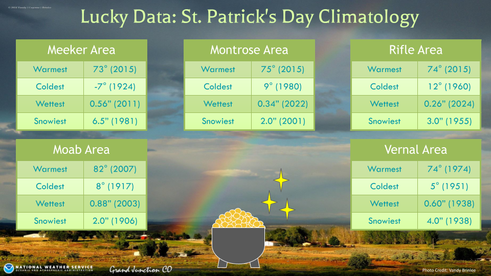
Let's take a look at some "Lucky Data" (aka St. Patrick's Day Climatology) for selected cities across eastern Utah and western Colorado. By far the most impressive St. Patrick's Day took place in 1981 when a late season snowstorm dropped 7 inches of snow in the Aspen area with 6.5 inches in Meeker. Although some snow in the Aspen area in 2022 just surpassed that 7.0 inch record. The lowest minimum temperature on St. Patrick's Day was -7 degrees which occurred in the Meeker area in 1924. The warmest temperature of 82 degrees occurred in the Moab area in 2007.
For more climate information from other sites, please visit our climate page on our website at https://www.weather.gov/wrh/climate?wfo=gjt. You can also follow us on Facebook (@NWSGrandJunction) or X (@nwsgjt).
Hazards
Detailed Hazards Viewer
National Briefing
Outlooks
Transportation Decision Support
Winter Storm Severity Index
Forecasts
Aviation Weather
Fire Weather
Forecast Discussion
Forecast Points
Local Area
Severe Weather
Soaring Forecast
Winter Weather
Hydrology
Recreational River Report
River Forecast
Weather Safety
Preparedness
NOAA Weather Radio
StormReady
SkyWarn
US Dept of Commerce
National Oceanic and Atmospheric Administration
National Weather Service
Grand Junction, CO
2844 Aviators Way
Grand Junction, CO 81506-8644
970-243-7007
Comments? Questions? Please Contact Us.

