Overview
|
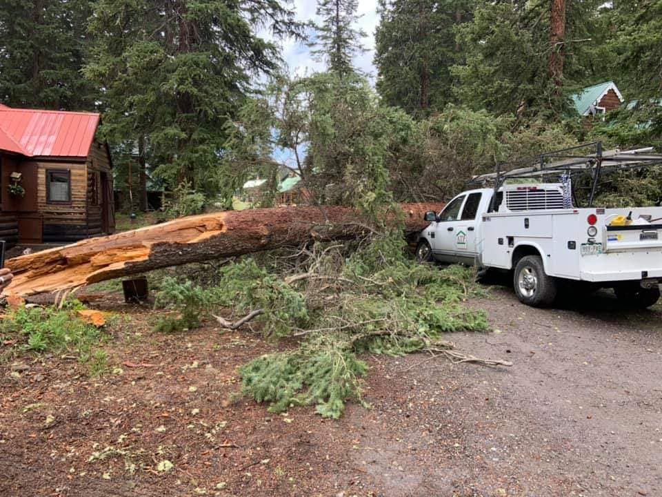
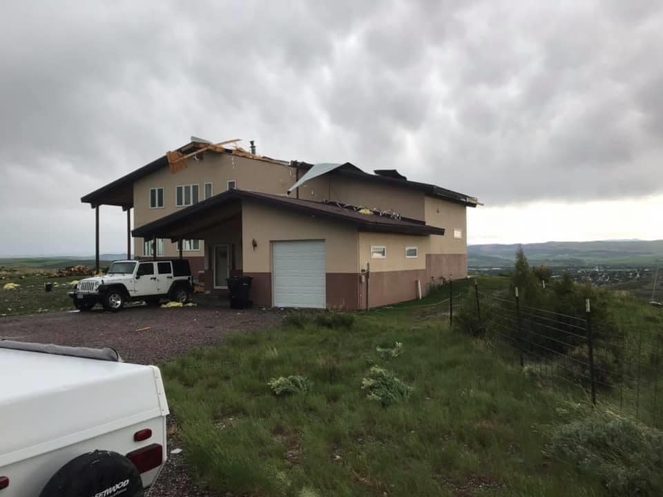
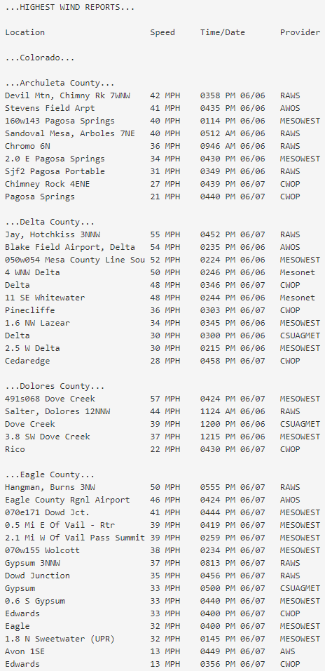
A Flash Flood Watch was in place by the afternoon of the 5th of June for all of eastern Utah and southwestern Colorado as a very moist and strong system approached the Great Basin. Hot, dry and windy conditions preceded this moisture however with critical fire weather conditions spread across a large portion of the region. Grand Junction also reached a record high of 100 degrees Friday afternoon. Thunderstorms formed on the nose of the arriving moisture late in the afternoon of June 5th across the 4 Corners region. A strong, northward moving, outflow boundary was produced from these initial storms and survived to the Wyoming border by late in the evening. The fast movement of the boundary enhanced the wind threat from thunderstorms forming along it, and numerous reports of strong outflow winds and localized damage were received. In addition, lightning and strong winds exacerbated the growth of existing fires and contributed to numerous fire starts across western Colorado. Early Saturday morning much of eastern Utah and western Colorado, near the state line, was experiencing moderate to heavy rainfall rates. Meanwhile, atmospheric conditions were becoming favorable for the likelihood of strong thunderstorm development. Strong outflow winds appeared to be the most probable threat, although all modes of severe weather would be possible, between 1000-1400 MDT. Short-lived clearing in southeast Utah provided just enough time to destabilize the atmosphere and the initial thunderstorms that formed quickly evolved into discrete supercells around mid-morning. As these storms dropped hail up to the size of golf balls and produced 70+ mph wind gusts, a Severe Thunderstorm Watch was issued for the entirety of eastern Utah and western Colorado. Both of these are very rare events in this part of the world. Slower moving storms with extreme rainfall rates also caused flash flooding across a portion of southern San Juan County, Utah. The initial thunderstorms transitioned into a larger line of fast moving storms...leading to the beginning stages of what would become the first derecho to impact the Great Basin / western slopes in well over a decade. This derecho event extended from the 4 Corners to the western Dakotas. Although some lower valleys were spared, numerous reports of damaging winds spotted the CWA with several observations of winds up to and in excess of 80 mph estimated and measured. Trees were uprooted, at least one roof was torn off (with others damaged), several houses/cabins and vehicles were damaged by falling trees and/or large hail, and power lines were downed. The heavy rainfall also impacted reservoir operations and several streams saw rapid increases in flow. |
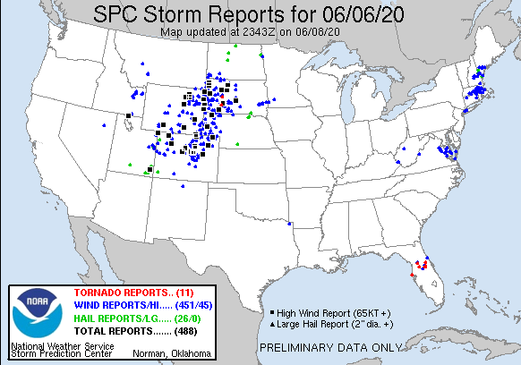 Severe Weather Reports For June 6 2020 |
 |
 |
 |
| Grand Mesa, Colorado (Shawn Montgomery) | Craig, Colorado (Lucas Bergstrom) | Craig, Colorado (Lucas Bergstrom) |
Wind & Hail:
Add a written summary or simply an LSR map in this section. If writing an extensive report, you can break the report down into wind and hail below (otherwise delete).
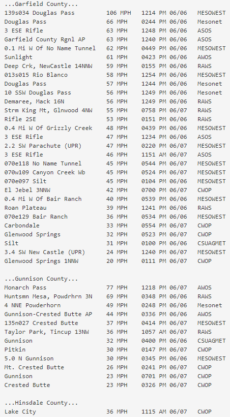
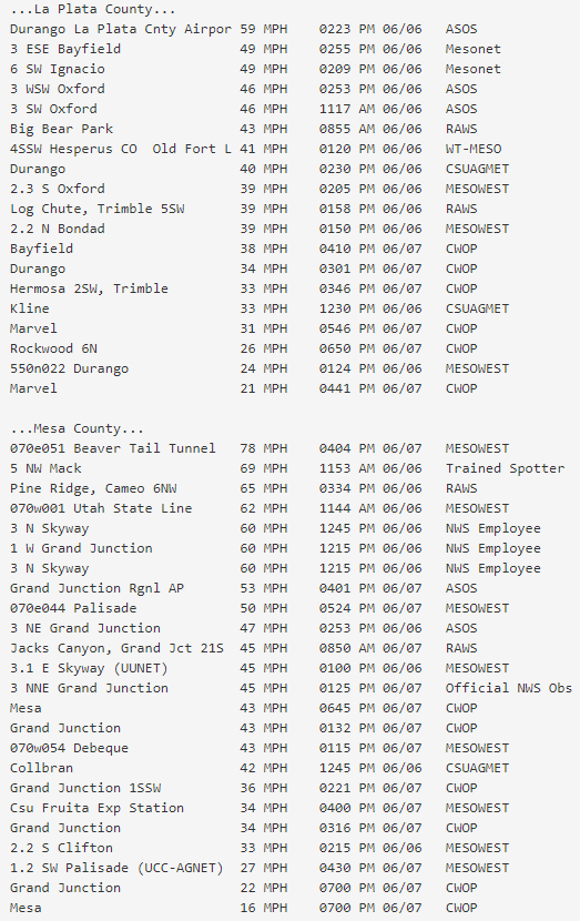
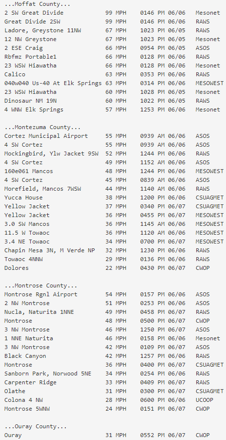
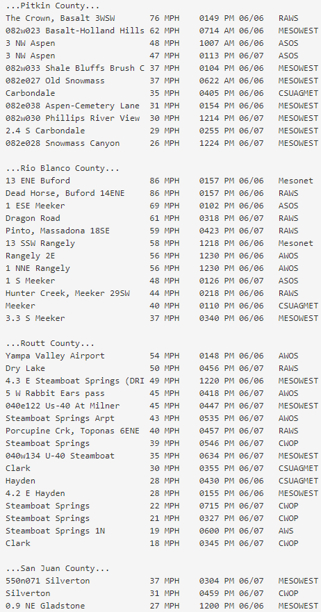
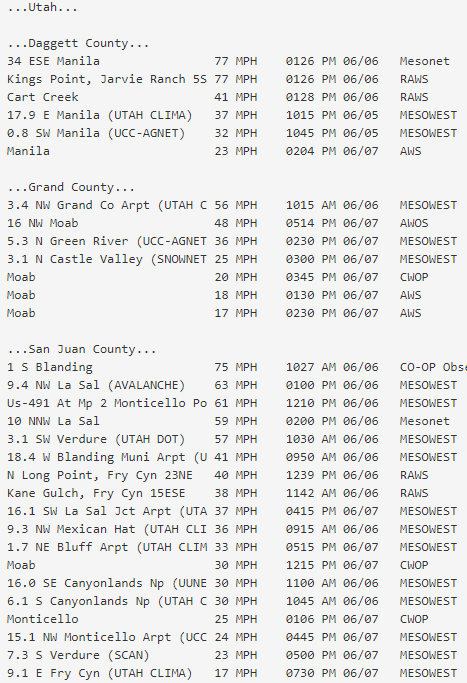
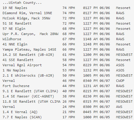
Wind
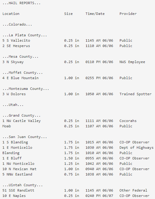
Hail
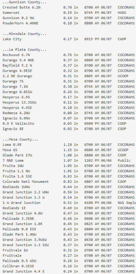
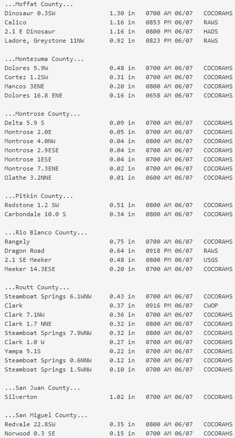
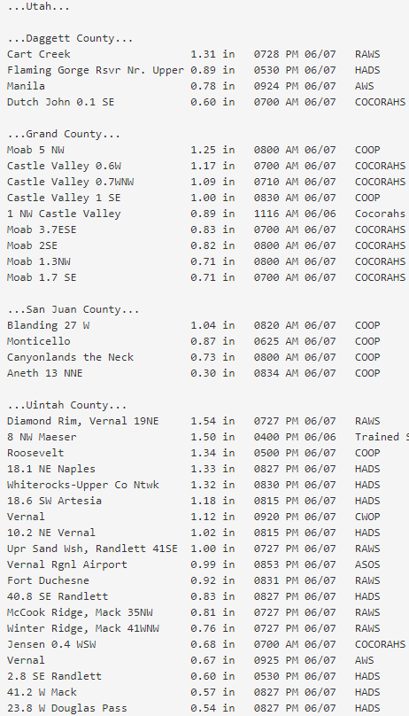
Rain Reports
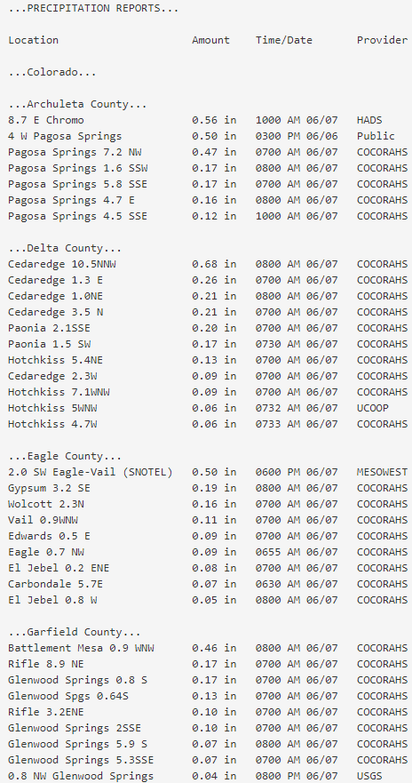
Insert rainfall reports here. Copy in PNS, paste rainfall map, or create table.
 |
Media use of NWS Web News Stories is encouraged! Please acknowledge the NWS as the source of any news information accessed from this site. |
|

