Overview
|
A long-duration snowfall event began across northwest Colorado near the Wyoming border as early as the morning of Monday, January 2nd, as moisture off the Pacific began to work its way across the area. This coincided with an arctic front that remained stationary across the north near the Wyoming border, producing significant snowfall under heavy snow bands for the northern Park range and northwest Colorado valleys, where Craig picked up over a foot of snow through the afternoon of Tuesday, January 3rd. A break in the action occurred late Tuesday afternoon as the arctic front retreated northward as milder air and deeper moisture surged ahead of the strong trough that brought significant snowfall to the region from late in the day on Wednesday, January 4th through the early morning hours on Friday, January 6th. The snow fell as a result of a plume of moisture surging inland along the Pacific Coast, and continuing east into the central Rocky Mountains. This moisture fetch off the Pacific is also known as an Atmospheric River, or "Pineapple Express" event. An arctic cold front moved south from Wyoming and into northern Colorado during the day on January 5th, enhancing snowfall across the region. The key to this event was the progress of the arctic front and resulting heavy banding of snow that resulted in some areas seeing much higher totals than other locations nearby. The arctic front stalled along the I-70 corridor by the morning of Thursday, January 5th resulting in heavy snow banding for parts of this area. The arctic front progressed towards the central and southern mountains Thursday afternoon and stalled over the San Juans, keeping the southern valleys near the Four Corners very mild with rain and thunderstorms. This arctic front eventually dropped south through the Four Corners region Thursday evening, resulting in a changeover to snow and some brief heavy snow banding before quickly dropping south of the border after midnight. This storm was notable for producing a plowable snowfall in the Grand Valley and many other lower-elevation locations after temperatures cooled behind the front. Throughout the Colorado high country, snowfall totals ranged from 1 to 2 feet in the San Juan Mountains to 3 feet or more in the central and northern mountains. Locally higher amounts up to 5 feet were seen in some mountain locations with the Tower snotel in the Park Range the grand winner with an estimated 66 inches! One of the more impressive valley totals was Gunnison with close to 2 feet of snow. |
Preliminary Storm Total Snowfall from Wednesday, Jan 4th thru Friday, Jan 6th. Note: These totals do not include the amounts that fell across northwest Colorado with the leading disturbance on Monday, Jan 2nd thru Tuesday, Jan 3rd. |
 |
 |
 |
| Snowfall outside the NWS Grand Junction office where 3.1" officially fell (NWS GJT) |
14" of snow on Pitkin Mesa near Paonia (Bob Storvern) |
Grand Junction, CO area: Amounts varied from about 3" at the airport on the northern end of town to around 8" in the Redlands near the Colorado National Monument on the southern end of town (Rick Hudak) |
Photos & Video:
Snowfall pictures During the Storm and Hazardous Travel Conditions
 |
 |
 |
 |
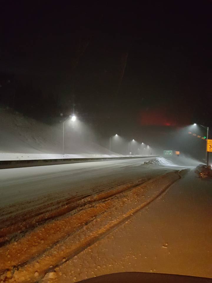
| Eisenhower Tunnel I-70 on Jan 3rd (Kevin Anderson) |
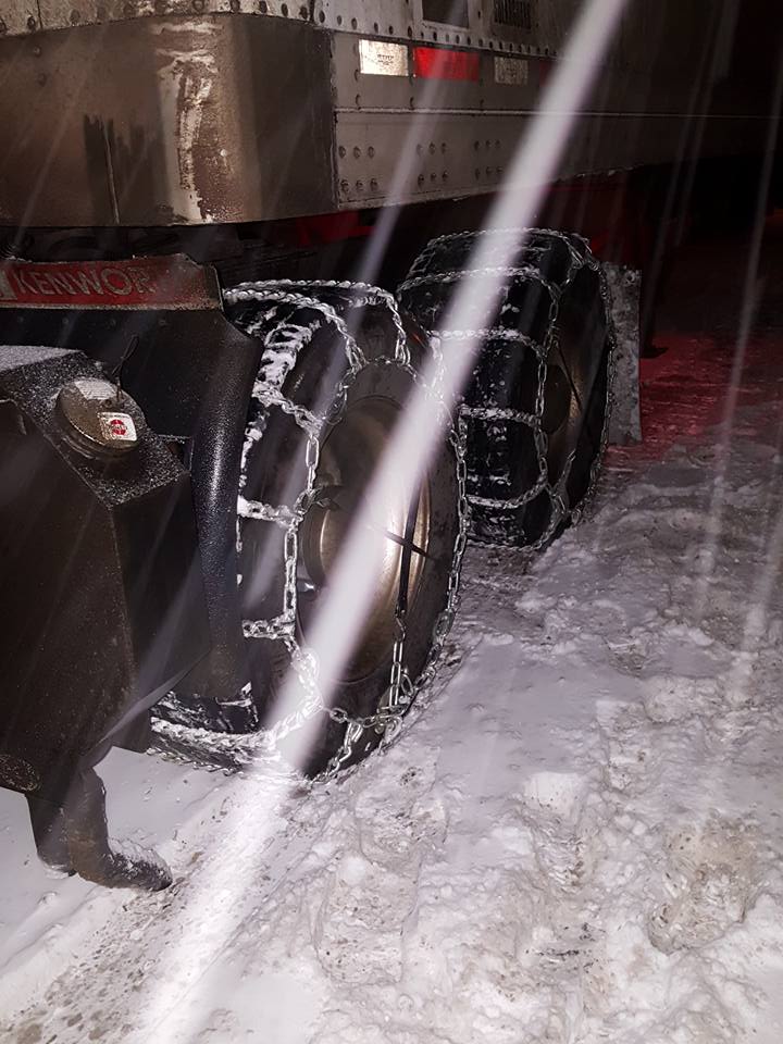
Eisenhower Tunnel I-70 Chaining Up on Jan 3rd (Kevin Anderson) |
Closure on Loveland Pass on Jan 3rd (Kevin Anderson) |
Eagle, CO on Jan 4th (Emily Ehlert) |
 |
 |
 |
 |
| Highway 50 between Olathe and Montrose, CO on Jan 5th (Abbie Beckwith Dodson) |
12" in Gypsum, CO on Jan 5th (Lisa Figgs) |
Nighttime driving conditions on Highway 550 with wind drifts (CAIC) |
Tour bus incident on Highway 145 on Jan 5th (San Miguel Sheriff's Office) |
Avalanche Mitigation on Highway 550 in the San Juan Mountains:
Strong Winds and Heavy Snow Accumulation on January 5th resulted in a closure of Red Mountain Pass due to avalanche threat, where 3 natural avalanches occurred during this time period. Numerous slides were also triggered to help with mitigating the avalanche threat.
 |
 |
 |
| Avalanche Debris and plastered trees on Coal Bank Pass (CAIC) |
Avalanche powder cloud produced by triggered avalanche near Red Mountain Pass (CAIC) |
Triggered avalanche debris on Red Mountain Pass (CAIC) |
 |
 |
 |
| Avalanche clean up on Red Mountain Pass (CAIC) |
Avalanche debris on Highway 550 after blower cleared path (CAIC) |
Morning after the storm on Coal Bank Pass - Trees plastered by winds (CAIC) |
Pristine Snowfall Photos in the Aftermath of the Storm (photos taken January 6th)
 |
 |
 |
 |
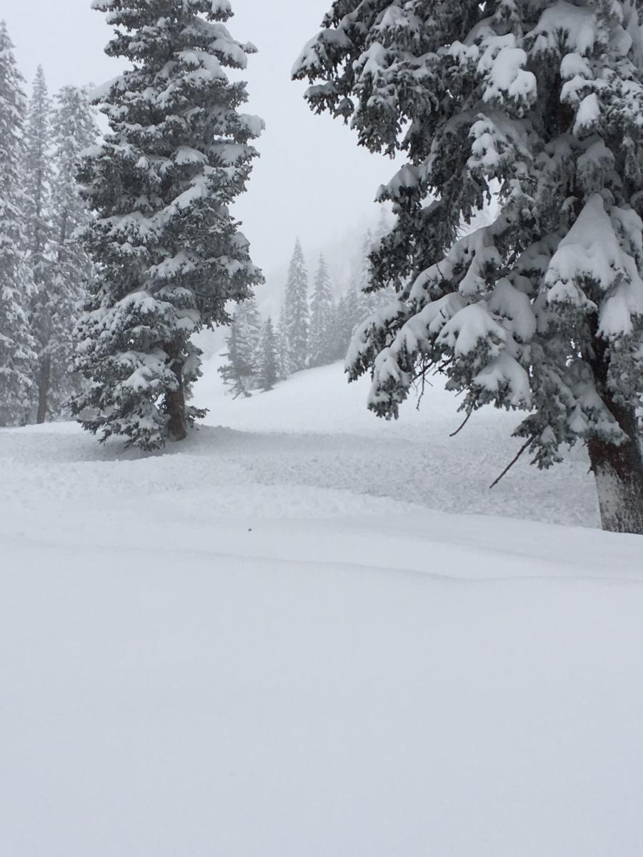
| Aspen, CO (Pablo Baez) |
Crested Butte, CO (Eric Yackel) |
Sundogs in Cimarron Ridge, CO (David Olivero) |
"Snowed In" in Clark, CO (Maryedith Davies) |
 |
 |
 |
 |
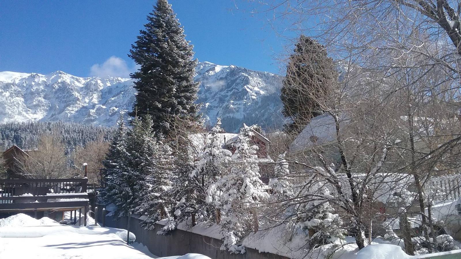
| Ouray, CO (Mandy Simpson) |
7" in Redlands, CO with view of Colorado National Monument (Joe and Kathy Kimbrough) |
Pagosa Springs, CO (Dottie George) |
Sunset in Paonia, CO (Michael Jensen) |
Colorado and Utah Snowpack Update
 |
 |
 |
 |
| Utah Snowpack - Jan 1, 2017 (before the storm) (Credit: USDA/NRCS) |
Utah Snowpack - Jan 7, 2017 (after the storm) (Credit: USDA/NRCS) |
Colorado Snowpack - Jan 1, 2017 (before the storm) (Credit: USDA/NRCS) |
Colorado Snowpack - Jan 7, 2017 (after the storm) (Credit: USDA/NRCS) |
Storm Reports
Snow began falling across the northern portion of eastern Utah
and western Colorado on Tuesday, slowly spreading southwards
Wednesday and Thursday, ending from north to south Thursday and
Thursday night. Following are preliminary storm total snowfall
reports.

Estimated storm total snowfall amounts across the mountains of
eastern Utah and western Colorado are as follows:

Northwest Colorado Mountains:
Elkhead and Park Ranges......20 to 35 inches, with 65 at Tower
Flat Tops....................10 to 30 inches

West Central Colorado Mountains:
Grand Mesa...................10 to 20 inches
Gore and Elk Ranges..........15 to 30 inches
West Elk and Sawatch Ranges..20 to 50 inches

Southwest Colorado Mountians:
Umcompagrre Plateau..........35 to 45 inches
Northwest San Juans..........15 to 30 inches
Southwest San Juans..........15 to 35 inches

Eastern Utah Mountains:
Eastern Uintas..............5 to 15 inches
Tavaputs Plateau............3 to 8 inches
La Sal and Abajo Ranges.....5 to 15 inches


...Snowfall Reports...

Location                     Amount    Time/Date       Provider

...Colorado...

...Archuleta County...
Pagosa Springs 15.0 SSE      8.0 in    0745 AM 01/06   COCORAHS
Pagosa Springs 1.6 SSW       6.9 in    0830 AM 01/06   COCORAHS

...Delta County...
Hotchkiss 4NW                8.0 in    0612 PM 01/05
Cedaredge 1.0 NE             7.5 in    0800 AM 01/06   COCORAHS
Eckert 1.1 SW                6.8 in    0700 AM 01/06   COCORAHS
Cedaredge 10.5 NNW           19.5 in   0800 AM 01/06   COCORAHS
Paonia 2.1 SSE               16.5 in   0800 AM 01/06   COCORAHS
Crawford                     14.0 in   0657 PM 01/05
Paonia                       13.5 in   0904 PM 01/05
Hotchkiss 7.1 WNW            11.3 in   0700 AM 01/06   COCORAHS
Hotchkiss                    11.0 in   0613 PM 01/05


...Eagle County...
Gypsum 0.4 WNW               7.4 in    0700 AM 01/06   COCORAHS
Carbondale 5.7 E             6.4 in    0810 AM 01/06   COCORAHS
Basalt 5.8 E                 5.1 in    0700 AM 01/06   COCORAHS
Wolcott 2n                   4.8 in    0700 AM 01/06   UCOOP
Wolcott 2.3 N                4.8 in    0700 AM 01/06   COCORAHS
Vail 2.6 E                   17.8 in   0700 AM 01/06   COCORAHS
Vail 0.9 WNW                 13.7 in   0700 AM 01/06   COCORAHS
Gypsum                       12.0 in   0800 PM 01/05
Gypsum 1.9 SSW               10.4 in   0700 AM 01/06   COCORAHS

...Garfield County...
Glenwood Springs .64 S       7.3 in    0700 AM 01/06   COCORAHS
Glenwood Springs 7.2 S       6.8 in    0700 AM 01/06   COCORAHS
Glenwood Springs 5.3 SSE     6.2 in    0700 AM 01/06   COCORAHS
Carbondale 0.5 W             3.0 in    0630 AM 01/06   COCORAHS
Alternbern Coop              2.0 in    0700 PM 01/05   COOP
Carbondale 4.6 NNE           11.3 in   0700 AM 01/06   COCORAHS
Rifle 3ene                   0.7 in    0700 AM 01/06   COOP
Rifle 3.2 ENE                0.7 in    0700 AM 01/06   COCORAHS

...Gunnison County...
Crested Butte 6.2 N          36.5 in   0700 AM 01/06   COCORAHS
Gothic                       36.5 in   0700 AM 01/06   UCOOP
Pitkin 1.1 SW                28.5 in   0700 AM 01/06   COCORAHS
1 N Gunnison                 24.4 in   0850 AM 01/06
Pitkin 1.1 SW                24.0 in   0700 AM 01/06   COCORAHS
Irwin Guides Study Plot      23.7 in   0900 AM 01/06   CAIC
Gunnison Coop                19.8 in   0800 AM 01/06   COOP
Powderhorn 4.4 NNE           19.2 in   0800 AM 01/06   COCORAHS
Irwin Ski Lodge              17.0 in   0511 PM 01/05
Gunnison                     16.5 in   0554 PM 01/05
Taylor Rvr Blo Tayor Park Rs 16.5 in   0500 PM 01/05   COOP
Irwin Guides Study Plot      16.0 in   0900 AM 01/06   CAIC
Gunnison 6.6 N               15.8 in   0700 AM 01/06   COCORAHS
Doyleville 2.1 W             15.5 in   0825 AM 01/06   COCORAHS
Gunnison Coop                14.8 in   0800 AM 01/06   COOP
Cimarron 11.2 S              12.3 in   0700 AM 01/06   COCORAHS
Doyleville 2.1 W             11.5 in   0825 AM 01/06   COCORAHS
Taylor Park                  10.5 in   0550 PM 01/05


...La Plata County...
5 W Vallecito                7.7 in    0700 AM 01/06   COCORAHS
Bayfield 7.0 N               7.0 in    0700 AM 01/06   COCORAHS
Bayfield 7N                  4.0 in    0700 AM 01/06   UCOOP
Durango 4.8 WSW              2.8 in    0700 AM 01/06   COCORAHS
Hesperus 13.3 SSW            2.2 in    0715 AM 01/06   COCORAHS
Rockwood 6.9 NNW             19.2 in   0700 AM 01/06   COCORAHS
Ignacio Spotter              1.3 in    0700 AM 01/06   COOP
Durango 0.8 SSW              0.3 in    0700 AM 01/06   COCORAHS

...Mesa County...
Collbran                     9.8 in    0717 PM 01/05
Mesa 6S                      9.7 in    0959 AM 01/06
17 W Glade Park              8.6 in    0800 AM 01/06   COOP
Orchard Mesa                 8.0 in    0620 PM 01/05
east entrance of CO NM       7.5 in    1013 AM 01/06
1 NNW Redlands               7.0 in    0453 PM 01/05
Redlands                     6.5 in    0636 PM 01/05
Redlands 2SE                 6.5 in    0548 PM 01/05
Grand Mesa - Skyway Pt       6.3 in    0900 AM 01/06   CAIC
Redlands                     6.2 in    1029 PM 01/05
Grand Junction 4.1 W         6.2 in    0700 AM 01/06   COCORAHS
2 WNW Redlands               5.9 in    0700 AM 01/06   COCORAHS
1 E Redlands                 5.9 in    0700 AM 01/06   COCORAHS
Grand Junction 3.9 WSW       5.8 in    0700 AM 01/06   COCORAHS
1 ENE Redlands               5.0 in    0545 PM 01/05
1 SSW Grand Junction         4.9 in    1041 PM 01/05
Grand Junction               4.5 in    0640 PM 01/05
1 W Fruitvale                3.8 in    0700 AM 01/06   COCORAHS
Grand Junction               3.5 in    1022 AM 01/06
Wfo Grand Junction           3.1 in    1200 AM 01/06   COOP
Grand Junction 5NNW          3.1 in    0800 AM 01/06
Whitewater                   3.0 in    0719 PM 01/05
1 NW Fruita                  3.0 in    0315 PM 01/05
Fruitvale                    2.8 in    0720 AM 01/06   COCORAHS
3 E Plateau City             14.3 in   0700 AM 01/06   COCORAHS
Collbran                     14.0 in   0552 PM 01/05
Collbran 0.2 ESE             13.0 in   0700 AM 01/06   COCORAHS
Collbran                     13.0 in   0800 AM 01/06   UCOOP
1 ESE Plateau City           10.8 in   1037 PM 01/05
Palisade Coop                0.1 in    0700 AM 01/06   COOP

...Moffat County...
Craig Coop                   3.7 in    0700 AM 01/06   COOP
Dinosaur 0.3 SW              2.7 in    0730 AM 01/06   COCORAHS


...Montrose County...
Montrose 7.3 ENE             9.0 in    0700 AM 01/06   COCORAHS
Montrose                     9.0 in    1025 PM 01/05
4 NW Montrose                8.5 in    1102 PM 01/05
Colona 4nw                   8.5 in    0600 PM 01/05   UCOOP
Montrose 4.0 NW              8.0 in    0800 AM 01/06   COCORAHS
Montrose 8.1 WNW             8.0 in    0700 AM 01/06   COCORAHS
Montrose 1.2 ESE             7.5 in    0700 AM 01/06   COCORAHS
Montrose                     7.0 in    1042 PM 01/05
Montrose 3SW                 4.0 in    0509 PM 01/05
Nucla                        4.0 in    1236 AM 01/06
Montrose 1.6 E               11.3 in   0700 AM 01/06   COCORAHS
Paradox                      0.4 in    0600 AM 01/06   UCOOP

...Ouray County...
Ouray .23 NNW                7.3 in    0719 AM 01/06   COCORAHS
Ouray Spotter                7.3 in    0719 AM 01/06   COOP
Swamp Angel                  14.5 in   0600 AM 01/06   CAIC
Red Mountain Pass            18.0 in   0800 AM 01/06
Ridgway 3.3 NNW              15.2 in   0700 AM 01/06   COCORAHS
Silverton 6.9 NNW            14.5 in   1250 PM 01/06
5 SW Colona                  14.0 in   0730 AM 01/06   COCORAHS
3 SW Colona                  11.5 in   0840 AM 01/06   COCORAHS


...Routt County...
Yampa 5.1 S                  9.4 in    0700 AM 01/06   COCORAHS
Hayden Coop                  9.0 in    0600 PM 01/05   COOP
Oak Creek 5.5 E              7.5 in    0700 AM 01/06   COCORAHS
Hayden                       6.0 in    0600 PM 01/05
Clark 0.7 NW                 29.0 in   0700 AM 01/06   COCORAHS
Steamboat Springs 1.9 E      27.2 in   0600 AM 01/06   COCORAHS
Steamboat Springs 0.7 ESE    20.1 in   0700 AM 01/06   COCORAHS
Steamboat Lake State Park    2.9 in    0600 AM 01/06   CAIC
Steamboat Springs 1.2 SE     13.5 in   0710 AM 01/06   COCORAHS
Steamboat Springs 0.7 ESE    13.0 in   0700 AM 01/06   COCORAHS
Steamboat Springs 1.1 E      12.7 in   0700 AM 01/06   COCORAHS
Yampa 5.1 S                  10.2 in   0700 AM 01/06   COCORAHS

...San Juan County...
Coal Bank Pass               29.5 in   0800 AM 01/06
Molas Pass                   26.0 in   0800 AM 01/06

...San Miguel County...
2 W Telluride                3.1 in    1200 AM 01/06   MISC
4 NE North Pole Peak         12.0 in   1008 AM 01/06
Telluride Ski Area           6.0 in    0600 AM 01/06   CAIC

...Utah...


...Grand County...
Moab Coop                    1.0 in    0400 PM 01/05   COOP
Moab                         1.0 in    0534 PM 01/05

...San Juan County...
Oljato                       5.0 in    1102 PM 01/05

...Uintah County...
Radio Station Kneu           2.5 in    0500 PM 01/05   COOP
Vernal                       2.0 in    0630 AM 01/06   COOP
Vernal 0.8 S                 2.0 in    0630 AM 01/06   COCORAHS
Jensen 0.4 WSW               1.6 in    0700 AM 01/06   COCORAHS
2 NW Ballard                 1.5 in    0651 PM 01/05
Jensen 0.4 WSW               1.5 in    0700 AM 01/06   COCORAHS
Vernal                       1.4 in    0630 AM 01/06   COOP
Vernal 0.8 S                 1.4 in    0630 AM 01/06   COCORAHS
Naples                       0.7 in    0700 AM 01/06   COCORAHS
Dinosaur Nat'l Mon - Quarry  0.2 in    0900 AM 01/06   COOP


Observations are collected from a variety of sources with varying
equipment and exposures. Not all data listed are considered official.
 |
Media use of NWS Web News Stories is encouraged! Please acknowledge the NWS as the source of any news information accessed from this site. |
|


