
Thunderstorms, some severe, may produce heavy to excessive rainfall and isolated flooding over portions of the Southern Plains today and Saturday. Dry conditions, combined with gusty winds and low relative humidities will continue to support an elevated to critical fire weather threat in the Desert Southwest into to early next week. Read More >
Grand Junction, CO
Weather Forecast Office
More sunshine on tap today for eastern Utah and western Colorado as temperatures warm-up considerably thanks to southwesterly flow. Tomorrow, an approaching cold front will bring some showers and thunderstorms to the area, mainly north of I-70. Ahead of the front, winds will pick up for southwestern Colorado and with dry conditions already in place, critical fire weather conditions will be met. To that end, a Red Flag Warning has been issued for tomorrow afternoon to account for these conditions. Afternoon showers and storms will occur each afternoon and evening through Saturday.
High Temperatures Today

Minimum Relative Humidity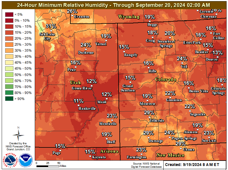
Red Flag Warning Valid Thursday for Southwestern Colorado

Tomorrow's Forecast

Hazards
Detailed Hazards Viewer
Outlooks
Winter Storm Severity Index
Transportation Decision Support
National Briefing
Current Conditions
Observations
Radar
Satellite
Snow Cover
Snowfall Analysis
Precip Analysis
Social Dashboard
Forecasts
Forecast Discussion
Local Area
Activity Planner
Aviation Weather
Fire Weather
Severe Weather
Winter Weather
Hurricane Center
Hydrology
Recreational River Report
Rivers and Lakes
Weather Safety
Preparedness
NOAA Weather Radio
StormReady
SkyWarn
Spotter Training Calendar
US Dept of Commerce
National Oceanic and Atmospheric Administration
National Weather Service
Grand Junction, CO
2844 Aviators Way
Grand Junction, CO 81506-8644
970-243-7007
Comments? Questions? Please Contact Us.

