The NWS in Hastings, NE conducted a damage survey of tornadoes which occurred Tuesday, October 9th, hitting parts of Hamilton, Merrick, Nance and Polk Counties in south central Nebraska. Two teams of meteorologists, along with emergency management personnel, surveyed the area.
One survey team covered northern Hamilton, Polk and extreme eastern Merrick Counties. A series of at least 4 tornadoes occurred along a 35 mlie path starting 7 SW of Marquette in northern Hamilton County, crossing the northwest half of Polk County and into the extreme eastern part of Merrick County near Silver Creek. With the exception of parts of western Polk County, damage along this path was rated a F1 on the Fujita Scale, with winds of 73-112 MPH.
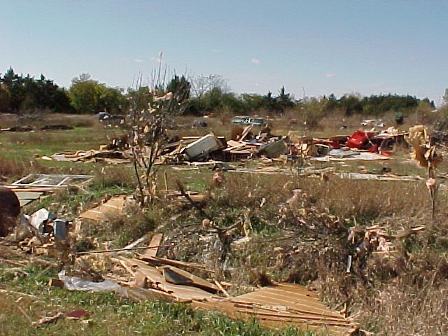
Initial reports of tornadoes southwest of Marquette eventually lead to the most significant tornado of the day. This multiple vortex, F3 tornado had winds of 158-206 MPH. One home located 3 N of Polk was blown completely from its foundation as the tornado passed. The tornado itself was likely 400 yards wide, although less severe damage was surveyed up to 1 mile away from the tornado itself. Damage in the Silver Creek area was caused by a tornado which developed in northern Polk County and crossed the river into town.
At least 20-30 farmsteads sustained some damage along the path of this family of tornadoes, with a common theme of machine sheds, grain bins and outbuildings being destroyed. Windows were broken and siding was torn from many homes. Property damage losses will be in the millions of dollars. Thousands of acres of unharvested crops were also lost. Not serious injuries were reported.
A second survey team covered the rest of Merrick County and the western half of Nance County. A total of 5 tornadoes were noted. One tornado began southeast of Chapman on the south side of the river, crossed into Merrick County and dissipated east of Champan. This F1 tornado caused broken windows, destroyed 2 outbuildings and knocked down power lines.
Survey results indicated the most damaging tornado in this area moved from 8 N of Central City, to 2 SW of Fullerton near the Loup River. One farmstead in northern Merrick County sustained approximately 250,000 dollars in damage. Damage was consistent with a F2 tornado, with winds of 113-157 MPH. At its widest point, the path was up to 300 yards wide. Two miles to the north, near the Nance/Merrick County line, grain bins, a barn and garage were destroyed. Other tornadoes were reported in the county, with one in the far northwest part of the county on the ground for about 4 miles. Again, no serious injuries were reported.
Click on the following images to enlarge.


The following are PRELIMINARY severe weather reports from October 9th.
TIME(CDT) CITY LOCATION STATE EVENT/REMARKS COUNTY LOCATION
0440 PM 2 S ELBA NE 1.75 INCH HAIL 10/09/01 HOWARD
0442 PM NORTH BRANCH KS 1 INCH HAIL 10/09/01 JEWELL
0455 PM CENTRAL CITY NE .88 INCH HAIL 10/09/01 MERRICK
0456 PM 2 E NATOMA KS 1.75 INCH HAIL 10/09/01 OSBORNE
0510 PM CHAPMAN NE TORNADO 10/09/01 MERRICK BLDGS/ PIVOTS DESTROYED
0515 PM 2 NE WOLBACH NE TORNADO 10/09/01 GREELEY BRIEF TOUCHDOWN
0520 PM 10 N CENTRAL CITY NE TORNADO 10/09/01 MERRICK 2 HOUSES DESTROYED
0524 PM 13 SW OSBORNE KS .75 INCH HAIL 10/09/01 OSBORNE
0532 PM 1 SW MARQUETTE NE TORNADO 10/09/01 HAMILTON MULTIPLE FUNNELS
0545 PM EDGAR NE .88 INCH HAIL 10/09/01 CLAY
0553 PM 2 E POLK NE TORNADO 10/09/01 POLK REPORTED BY SHERIFFS OFFICE
0555 PM BURR OAK KS 1 INCH HAIL 10/09/01 JEWELL REPORTED BY COOP OBSERVER
0600 PM POLK NE .75 INCH HAIL 10/09/01 POLK
0610 PM 2 W FULLERTON NE 1 INCH HAIL 10/09/01 NANCE
0615 PM DOWNS KS 1 INCH HAIL 10/09/01 OSBORNE
0630 PM SILVER CREEK NE TORNADO 10/09/01 MERRICK CARS/ HOUSES DAMAGED
0802 PM MINDEN NE .75 INCH HAIL 10/09/01 KEARNEY
0843 PM 4N WEBSTER KS 1.00 INCH HAIL 10/09/01 ROOKS
0852 PM 1W FRANKLIN NE 1.00 INCH HAIL 10/09/01 FRANKLIN
0900 PM 13 W STOCKTON KS 0.75 INCH HAIL 10/09/01 ROOKS
0905 PM 2 S PROSSER NE 1 INCH HAIL 10/09/01 ADAMS
0935 PM 7 N HASTINGS NE .75 INCH HAIL 10/09/01 ADAMS
0935 PM FRANKLIN NE 0.75 INCH HAIL 10/09/01 FRANKLIN

