Hastings, NE
Weather Forecast Office
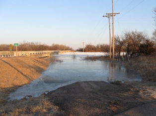
During the day on Sunday, February 27, 2011 Emergency Managers and Law Enforcement from Platte, Polk, and Merrick Counties reported that an ice jam had developed on the Platte River. The location of the ice jam was near the Highway 92 bridge south of Clarks. The ice jam has caused river levels to rise, threatening nearby homes, cabins and roads. On Sunday evening, a dirt dike was built to help protect homes on the south side of the river. The flooding has continued on into Monday, February 28th, and a mile and a half of Prairie Island Road, which is west of Highway 92 and just south of the Platte River in Merrick County, was closed due to rising water levels. As of Monday afternoon the ice jam is approximately 3 miles long, and according to area residents, had grown further west since Sunday evening.
On March 1st, Polk County Emergency Management reported that the river was up, and the ice jam remained unchanged.
Photos below show the extent of the ice jam and flooding, courtesy of Bob Carey, Emergency Manager of Polk County.
Additional photos of the ice jam (shown below) were taken by John, Linda and Angela Oder on February 28th and March 1st.
Hazardous Weather
Submit A Storm Report
Storm Prediction Center
Local Storm Reports
Experimental Graphical Hazardous Weather Outlook
Forecasts
Area Forecast Discussion
Fire Weather
Aviation Weather Center
Experimental Probabilistic Precip Amount Forecast
Winter Weather
Winter Storm Severity Index
Experimental Winter Storm Outlook
Wet Bulb Globe Temp
Activity Planner
Current Conditions
Current Area Observations
Text Products
Satellite
Rivers and Lakes
Local 24 Hour Precip Maps
Local Archived Precip Maps
NWPS Precipitation Analysis
Local Snowfall Maps
Snowfall Analysis
Snow Cover
Climate
Local Database (NOWData)
Local Climate Webpage
Hastings/G. Island Records
Local Historical Tornado Info
U.S. Drought Monitor
Grand Island - Daily
Grand Island - Monthly
Hastings - Daily
Hastings - Monthly
Kearney - Daily
Kearney - Monthly
Ord - Daily
Ord - Monthly
US Dept of Commerce
National Oceanic and Atmospheric Administration
National Weather Service
Hastings, NE
6365 North Osborne Drive West
Hastings, NE 68901-9163
402-462-4287
Comments? Questions? Please Contact Us.


