Overview/Narrative:
(BE SURE TO CLICK THE VARIOUS TABS BELOW FOR A VARIETY OF OCTOBER 2018 CLIMATE INFORMATION!)
|
Recap of October 2018 Weather for the 30-county NWS Hastings Coverage Area:
|
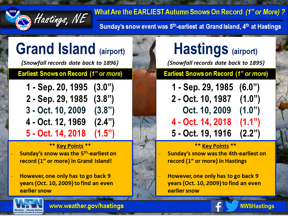
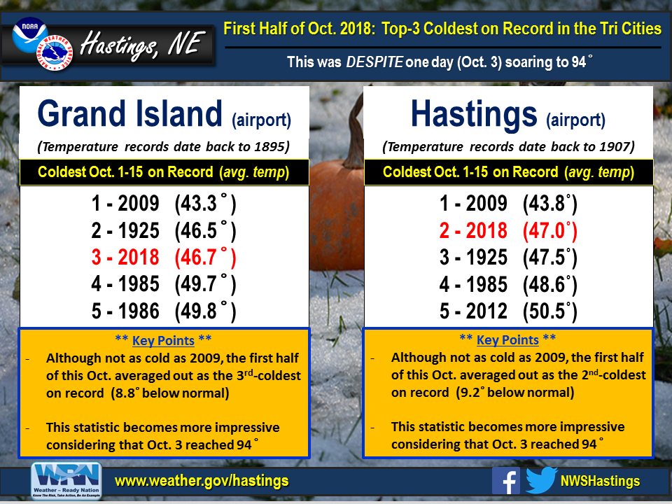
Grand Island & Hastings Details (Including 12-Month History):
 |
| Detailed October 2018 info for Grand Island/Hastings (Click to enlarge) |
 |
 |
| Grand Island Precipitation Summary: The green line indicates cumulative observed precipitation for October 2018.The brown line indicates "normal" October precipitation based on 30-year data from 1981-2010. (click to enlarge) | Hastings Precipitation Summary: The green line indicates cumulative observed precipitation for October 2018. The brown line indicates "normal" October precipitation based on 30-year data from 1981-2010. (click to enlarge) |
| Grand Island (Regional Airport ASOS) - Nov. 2017 - Oct. 2018 | ||||||||||||
| Nov. | Dec. | Jan. | Feb. | Mar. | Apr. | May | June | July | Aug. | Sept. | Oct. | |
| Average High (F) | 53.4 | 37.3 | 34.0 | 33.6 | 51.8 | 55.4 | 78.6 | 88.2 | 85.8 | 84.3 | 77.4 | 61.3 |
| Average Low (F) | 28.7 | 16.0 | 13.5 | 12.5 | 28.8 | 30.8 | 55.5 | 64.8 | 64.6 | 62.5 | 57.4 | 38.1 |
| Average Temperature (F) | 41.1 | 26.6 | 23.7 | 23.1 | 40.3 | 43.1 | 67.0 | 76.5 | 75.2 | 73.4 | 67.4 | 49.7 |
| Departure From Normal | +3.0 | -0.1 | -1.4 | -6.0 | +0.9 | -7.5 | +5.8 | +5.2 | -1.0 | -0.6 | +2.3 | -2.5 |
| Precipitation (in) | 0.51 | 0.45 | 1.08 | 0.75 | 1.26 | 1.26 | 3.98 | 4.61 | 3.58 | 2.67 | 2.49 | 2.88 |
| Departure From Normal | -0.66 | -0.18 | +0.55 | +0.07 | -0.54 | -1.27 | -0.43 | +0.31 | +0.18 | -0.45 | +0.26 | +1.02 |
| Snowfall (in) | 0.2 | 7.2 | 10.2 | 10.6 | 0.4 | 4.1 | 0.0 | 0.0 | 0.0 | 0.0 | 0.0 | 1.5 |
| Departure From Normal | -2.9 | +2.1 | +3.7 | +4.3 | -5.0 | +2.6 | 0.0 | 0.0 | 0.0 | 0.0 | -0.1 | +0.5 |
| Hastings (Municipal Airport ASOS) - Nov. 2017 - Oct. 2018 | ||||||||||||
| Nov. | Dec. | Jan. | Feb. | Mar. | Apr. | May | June | July | Aug. | Sept. | Oct. | |
| Average High (F) | 53.1 | 37.9 | 35.3 | 34.3 | 52.3 | 55.6 | 78.2 | 87.0 | 85.5 | 83.3 | 76.4 | 60.9 |
| Average Low (F) | 28.6 | 15.9 | 14.3 | 12.4 | 27.8 | 30.6 | 55.6 | 65.0 | 65.1 | 63.1 | 58.2 | 38.7 |
| Average Temperature (F) | 40.9 | 26.9 | 24.8 | 23.4 | 40.1 | 43.1 | 66.9 | 76.0 | 75.3 | 73.2 | 67.3 | 49.8 |
| Departure From Normal | +2.2 | -0.7 | -1.2 | -6.5 | +0.2 | -7.6 | +5.6 | +4.2 | -1.8 | -1.1 | +1.7 | -2.8 |
| Precipitation (in) | 0.08 | 0.28 | 0.49 | 0.53 | 1.07 | 1.26 | 3.83 | 5.91 | 2.19 | 4.40 | 3.69 | 3.04 |
| Departure From Normal | -1.21 | -0.33 | +0.08 | +0.04 | -0.72 | -1.30 | -0.74 | +2.11 | -1.55 | +1.10 | +1.13 | +1.05 |
| Snowfall (in) | 0.0 | 5.8 | 5.9 | 8.0 | 0.3 | 6.9 | 0.0 | 0.0 | 0.0 | 0.0 | 0.0 | 1.1 |
| Departure From Normal | -2.6 | -0.3 | -0.1 | +1.5 | -4.9 | +5.7 | 0.0 | 0.0 | 0.0 | 0.0 | -0.2 | +0.1 |
Kearney - 12 Month Climate History:
All data here is from the official NWS observer at Kearney airport, with 24-hour observations taken around 7 a.m. ** PLEASE NOTE: This official Kearney data often differs slightly from the unofficial data recorded by the automated airport system (KEAR) **
| Kearney Airport (Coop Observer) - Nov. 2017 - Oct. 2018 | ||||||||||||
| Nov. | Dec. | Jan. | Feb. | Mar. | Apr. | May | June | July | Aug. | Sept. | Oct. | |
| Average High (F) | 52.3 | 38.7 | 32.2 | 32.9 | 51.9 | 53.8 | 75.9 | 86.6 | 84.6 | 82.3 | 77.6 | 59.0 |
| Average Low (F) | 26.8 | 15.5 | 11.1 | 10.6 | 26.1 | 28.6 | 52.7 | 62.9 | 63.0 | 59.9 | 55.8 | 35.7 |
| Average Temperature (F) | 39.6 | 27.1 | 21.6 | 21.7 | 39.0 | 41.2 | 64.3 | 74.7 | 73.8 | 71.1 | 66.7 | 47.3 |
| Departure From Normal | +2.6 | +1.2 | -3.0 | -6.4 | +1.3 | -7.5 | +4.8 | +4.9 | -0.9 | -1.5 | +3.2 | -3.6 |
| Precipitation (in) | 0.34 | 0.21 | 0.96 | 0.73 | 1.05 | 2.03 | 5.56 | 2.87 | 6.07 | 2.05 | 1.85 | 3.50 |
| Departure From Normal (in) | -0.68 | -0.36 | +0.47 | +0.18 | -0.74 | -0.20 | +1.38 | -1.06 | +2.79 | -1.03 | -0.22 | +1.46 |
| Snowfall (in) | 0.4 | 4.3 | 6.8 | 9.2 | 0.7 | 9.7 | 0.0 | 0.0 | 0.0 | 0.0 | 0.0 | 1.4 |
| Departure From Normal (in) | -2.7 | +0.8 | +2.4 | +4.1 | -3.9 | +7.9 | 0.0 | 0.0 | 0.0 | 0.0 | -0.2 | +0.7 |
Ord - 12 Month Climate History:
All snowfall data is from the NWS Cooperative Observer in town. In addition, winter precipitation totals often include Cooperative Observer data given that the automated airport equipment is not designed to accurately melt snowfall liquid equivalent (in most cases).
| Ord (Evelyn Sharp Field ASOS) - Nov. 2017 - Oct. 2018 | ||||||||||||
| Nov. | Dec. | Jan. | Feb. | Mar. | Apr. | May | June | July | Aug. | Sept. | Oct. | |
| Average High (F) | 53.4 | 36.6 | 34.3 | 31.2 | 49.9 | 54.1 | 75.4 | 84.0 | 84.0 | 82.2 | 75.4 | 59.5 |
| Average Low (F) | 24.3 | 14.1 | 10.2 | 9.0 | 25.5 | 27.3 | 51.8 | 60.8 | 62.0 | 59.1 | 54.5 | 33.6 |
| Average Temperature (F) | 38.9 | 25.3 | 22.2 | 20.1 | 37.7 | 40.7 | 63.6 | 72.4 | 73.0 | 70.6 | 65.0 | 46.5 |
| Departure From Normal | +2.6 | +0.4 | -2.4 | -7.7 | 0.0 | -8.1 | +4.3 | +3.2 | -1.4 | -2.4 | +1.4 | -3.1 |
| Precipitation (in) | 0.21 | 0.43 | 0.83 | 0.53 | 0.62 | 1.47 | 4.38 | 7.57 | 5.84 | 2.57 | 1.53 | 2.47 |
| Departure From Normal (in) | -0.86 | -0.16 | +0.46 | +0.09 | -0.83 | -1.12 | +0.57 | +3.45 | +2.87 | -0.59 | -0.91 | +0.54 |
| Snowfall (in) | 2.0 | 5.3 | 12.4 | 8.6 | 1.1 | 10.1 | 0.0 | 0.0 | 0.0 | 0.0 | 0.0 | 0.3 |
| Departure From Normal (in) | -3.3 | -2.1 | +5.6 | +2.6 | -4.8 | +7.6 | 0.0 | 0.0 | 0.0 | 0.0 | 0.0 | -0.8 |
Smith Center, KS - 12 Month Climate History:
All data is from the official NWS observer, with 24-hour observations taken around 7 a.m. As a result, data may vary slightly from true "Calendar Day".
| Smith Center KS (NWS Coop Observer) - Nov. 2017 - Oct. 2018 | ||||||||||||
| Nov. | Dec. | Jan. | Feb. | Mar. | Apr. | May | June | July | Aug. | Sept. | Oct. | |
| Average High (F) | 55.9 | 43.6 | 39.1 | 39.4 | 57.8 | 58.4 | 82.7 | 92.2 | 90.7 | 86.9 | 80.9 | 62.5 |
| Average Low (F) | 28.5 | 17.6 | 12.6 | 13.5 | 27.9 | 29.6 | 55.6 | 63.9 | 65.5 | 62.5 | 57.6 | 38.5 |
| Average Temperature (F) | 42.2 | 30.6 | 25.9 | 26.4 | 42.8 | 44.0 | 69.1 | 78.0 | 78.1 | 74.7 | 69.3 | 50.5 |
| Departure From Normal | +1.8 | +1.8 | -1.8 | -5.6 | +1.2 | -8.5 | +5.4 | +4.0 | -1.6 | -2.5 | +1.1 | -4.3 |
| Precipitation (in) | 0.09 | 0.11 | 0.32 | 0.31 | 1.05 | 0.91 | 2.62 | 6.33 | 3.98 | 3.25 | 3.88 | 4.61 |
| Departure From Normal (in) | -1.13 | -0.55 | -0.17 | -0.27 | -0.82 | -1.36 | -1.30 | +2.72 | +0.11 | -0.05 | +1.84 | +2.73 |
| Snowfall (in) | 0.2 | 2.0 | 3.5 | 7.6 | T | 2.0 | 0.0 | 0.0 | 0.0 | 0.0 | 0.0 | 1.2 |
| Departure From Normal (in) | -1.6 | -1.2 | -0.2 | +3.5 | -2.6 | +1.4 | 0.0 | 0.0 | 0.0 | 0.0 | -0.2 | +0.8 |
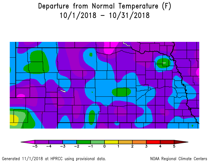
Temperature & Precipitation Departure From Normal Maps:
These images depict October 2018 monthly temperature departure from normal & precipitation percent-of-normal for both Nebraska & Kansas. Images are courtesy of the High Plains Regional Climate Center (HPRCC). Please note: These maps occasionally contain "bullseyes" of errant data. For precipitation, you can also generate departure from normal/percent-of-normal maps using the NWS AHPS page, or view local-area images generated each day by NWS Hastings.
 |
 |
 |
 |
| Departure from Normal Temperature - NE (left) & KS (right) | Percent of Normal Precipitation - NE (left) & KS (right) | ||
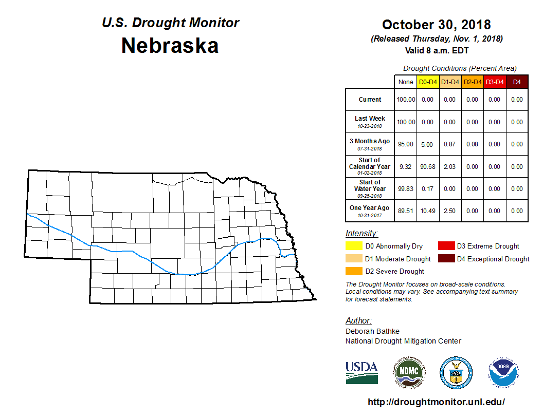
Drought:
The following drought images, current as of October 30, 2018, are courtesy of the U.S. Drought Monitor
Summary of changes during Oct. 2018 across the NWS Hastings coverage area:
Given that October precipitation was above-normal area-wide, it followed suit that the ENTIRE NWS Hastings coverage area remained void of all drought categories whatsoever during the month.
 |
 |
| Drought Monitor for Nebraska (left) & Kansas (right). Valid as of October 30, 2018 (click to enlarge) | |
October 2018 Extremes for the NWS Hastings Coverage Area:
...A FEW OF THE HOTTEST HIGH TEMPERATURES DURING OCTOBER 2018...
(all data from NWS cooperative observers or automated airport sites, with the date it actually occurred indicated in parentheses)
98 degrees...Beaver City (3rd)
95 degrees...Webster Dam KS (3rd) - Edison (3rd) - Smith Center KS (3rd) - Franklin (3rd) - Beloit KS (3rd)
94 degrees...Cambridge (3rd) - Harlan County Lake (3rd) - Oxford 6NNW (3rd) - Hastings airport (3rd) - Grand Island airport (3rd) - York 3N (3rd)
...A FEW OF THE COOLEST LOW TEMPERATURES DURING OCTOBER 2018...
(all data from NWS cooperative observers or automated airport sites, with the date it actually occurred indicated in parentheses)
17 degrees...Oxford 6NNW (15th)
18 degrees...Cambridge (15th) - Ord airport (15th) - Beaver City (15th)
19 degrees...Ravenna (15th)
20 degrees...Plainville KS 4WNW (15th) - Edison (15th) - Greeley (15th) - Gothenburg (15th)
...A FEW OF THE HIGHEST MONTHLY PRECIPITATION TOTALS DURING OCTOBER 2018...
(all data from NWS cooperative observers and CoCoRaHS/NeRAIN observers unless indicated)
6.69"...Osborne KS
6.58"...Covert KS (rural Osborne County)
6.52"...Beloit KS (10SSW)
6.50"...Jewell KS
6.35"...Natoma KS
6.21"...Cawker City KS - Ionia KS
6.02"...Beloit KS
5.68"...Burr Oak KS
5.48"...Damar KS (1NNW)
5.44"...Webber KS (3ENE)
5.29"...Guide Rock
...A FEW OF THE LOWEST MONTHLY PRECIPITATION TOTALS DURING OCTOBER 2018...
(all data from NWS cooperative observers and CoCoRaHS/NeRAIN observers unless indicated)
2.33"...Greeley​
2.40"...Miller
2.43"...Ravenna
2.44"...Elwood (8S)
2.47"...Ord airport ASOS
2.56"...Loup City
2.57"...Riverdale
2.76"...Cozad (4S) - Lexington (1E)
2.88"...Grand Island airport ASOS - Gresham (3W)
2.91"...Edison
...A FEW OF THE HIGHEST MONTHLY SNOWFALL TOTALS DURING OCTOBER 2018...
(all data from NWS cooperative observers and CoCoRaHS/NeRAIN observers unless indicated)
​7.0"...Geneva
6.8"...Shickley (4S)
5.0"...Clay Center (6ESE)
4.6"...Hebron
4.5"...McCool Junction
4.1"...Hubbell
4.0"...Clay Center
3.7"...Blue Hill (4SW)
3.2"...Phillipsburg (6E)
 |
Media use of NWS Web News Stories is encouraged! Please acknowledge the NWS as the source of any news information accessed from this site. |
|


