A storm survey team from the National Weather Service Office in Hastings has surveyed the damage from the tornado that struck the Kearney area on Thursday afternoon, May 29, 2008. The team determined that there were three main separate damage paths with the storms.
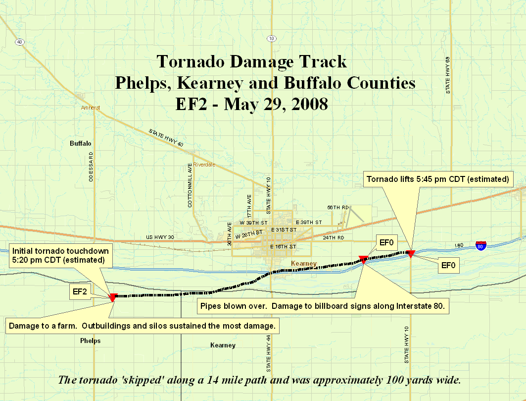
The first damage path began in northwest Phelps County at 5:20 p.m., and after skipping along a distance of about 15 miles, ended in Buffalo County near Interstate 80 exit 279 around 5:45 p.m. The damage caused by the strongest winds were estimated to be an EF-2 or between 111-135 mph. Damage was mainly confined to the collapse and destruction of a few farm out buildings, uprooted trees, light structural damage to several residences, and power poles blown over. The maximum width of th tornado damage was estimated to be 100 yards. There were no injuries or deaths.
---------------
The second damage path began around 5:15 p.m. in Buffalo County about 2 miles east of Odessa and ended near Shelton around 6:00 p.m. This wind damage, per eyewitness reports, featured the developement and dissipation of multiple weak tornadoes. None of these tornadoes remained on the ground for more than a few minutes, but there were tornadoes on the ground for almost the entire 25 mile path length. The damage noted was consistent with that of an EF-1 rating, or winds between 86-110 mph. This damage path began as scores of empty coal train cars were blown over. The tornadoes affected a large part of the central residential area in the city of Kearney. There were hundreds of trees and literally thousands of tree limbs that crashed into homes, businesses, and vehicles. There was some minor siding and roof damage to structures caused by the winds. These winds also knocked down power lines and signs and displaced several empty grain bins. The maximum width of the tornado damage was estimated to be less than 100 yards. There were no injuries or deaths reported with these tornadoes.
The blue dashed line represents the portion of the path were touchdowns were more sporadic.

---------------
The third tornado damage path was the most organized, as this tornado was the most persistent. It appeared to remain on the ground for the majority of its 30 mile long path. It began near Harmon Park in the city of Kearney around 5:25 p.m. It moved east through the Buffalo County Fairgrounds, causing the Expo Center to partially collapse. The tornado then continued east to the Kearney Airport where it destroyed a hanger and an aircraft housed inside. The tornado then continued to move east/northeast for nearly 30 miles before lifting about 6 miles north of Wood River in Hall County around 6:25 p.m. This tornado was rated a high end EF-2, or with winds estimated near 135 mph at times. Other damage caused by this long track tornado included multiple businesses on the northeast side of Kearney sustaining structural damage, including loading dock bay doors being blown in or sucked out and some collapsing of walls. When the tornado moved into rural areas, many farmsteads were hit. There was very limited damage to the residences, but many out buildings and empty grain bins were damaged or destroyed. There were multiple power poles and lines down by this storm. The maximum width of the tornado damage was estimated to be 400 yards. No injuries or deaths were reported with this storm.

---------------
A description of the EF scale can be found here.
Following are several photos taken by NWS Hastings personnel in the Kearney area during the damage survey on May 30, 2008.
.jpg)


