If you have any photos you would like to share, please feel free to post them to our Facebook or Twitter pages, or send them to our webmaster e-mail account at: w-gid.webmaster@noaa.gov. Please let us know where the photo was taken, and at least an approximate time. Thanks!
March 23-24, 2016: Winter Storm and Strong Winds Strike the Local Area
Event Summary
Although not as significant/crippling as the early-February blizzard several weeks prior, the first few days of spring 2016 brought a late blast of winter back to the NWS Hastings coverage area of South Central Nebraska/North Central Kansas (Click HERE for a map of the NWS Hastings area). A strong low pressure system (both at the surface and aloft) moved from west-to-east across the Central Plains from the daytime hours of Wednesday, March 23rd, into the morning hours of Thursday the 24th, dropping some locally-high snow totals and also promoting several hours of strong north/northeast winds with widespread, frequent gusts to 50 MPH or higher. There were even a few reports of wind damage. The combination of snow and strong winds resulted in blizzard-like conditions for portions of the area, especially during the evening hours of of the 23rd. Several road closures took place, including Interstate 80, which closed for several hours from Grand Island westward. During the pre-dawn hours of the 24th, snow steadily vacated the local area from west-to-east, with mostly sunny skies firmly in place by sunrise. Even though falling snow was long-gone by then, many folks were met with a slick Thursday morning commute due to lingering icy roads.
Taking a closer look at snow totals: Although amounts varied considerably across the area (see map below), the overall-highest totals of 6+" mainly targeted far northern local counties such as Valley/Greeley, including 8" in Ord. Farther south, a secondary band of heavier snow dropped generally 3-5" over Kearney County and portions of several neighboring counties. Elsewhere within the local area, most places saw lesser amounts ranging from 0-2", with the majority of far eastern/southeastern counties such as Fillmore/Thayer/Jewell/Mitchell seeing little to no snow. Actually snow was not the only precipitation type during this event, as much of the area started out with rain showers and non-severe thunderstorms that dropped a varied combination of small hail, graupel and sleet.
Even for those places where snow was not much of a factor, the ENTIRE 30-county area endured many hours of strong winds, with sustained speeds commonly 30-40 MPH and gusts as high as 45-60 MPH (see table of peak wind gusts below). These strong winds initially blew from the northeast, but became more northerly with time. There were a few known instances of legitimate wind damage, including a roof blown off of a business in Giltner and a large tree that fell on a home in Arcadia (see photos below).
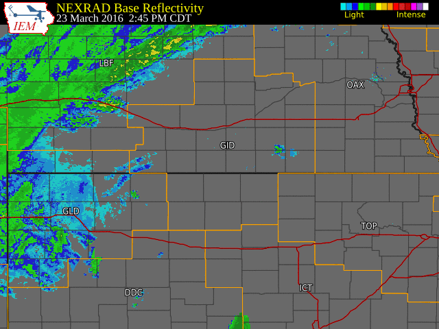
Radar Overview
The NWS radar loop below runs from 245 PM on March 23rd to 5 AM on March 24th. Note the initial onset of mainly rain showers/thunderstorms, followed by steadier snowfall later in the evening/overnight. The NWS Hastings coverage area is located within the orange outlined area labeled "GID", and Interstate highways are depicted by thicker red lines.
Click on image larger version
The first table below features a handful of the highest "official" snow reports from a combination of NWS Cooperative Observers and NeRAIN/CoCoRaHS observers, unless otherwise noted with a *.
| Location |
Storm Total Snowfall |
| Ord |
8.0 |
| 8 miles NNE Scotia |
7.5 |
| 2 ENE Axtell (NTV studios) |
5.0* |
| 9NW Ord |
5.0 |
| Minden |
4.0 |
| Greeley |
4.0 |
| 4E Scotia |
4.0 |
| 6S Wilcox |
4.0 |
| St. Paul |
3.2 |
| 2ENE Franklin |
3.5 |
| Kearney (airport) |
3.0 |
| 6W Elyria |
3.0 |
| Dannebrog |
3.0 |
| Grand Island (airport) |
2.6 |
| Arcadia |
2.5 |
| Holdrege |
2.5 |
| Ravenna |
2.0 |
| Hastings (NWS Office) |
1.9 |
The next table features a handful of the highest "official" peak wind gusts (all of which occurred on the 23rd), as measured by a mix of automated airport sensors (ASOS/AWOS) and home weather stations.
| Location |
Highest Known Gust (MPH) |
| Ord (airport) |
61 |
| 2E Axtell |
58 |
| 5NNW Oxford |
56 |
| Grand Island (airport) |
54 |
| York (airport) |
54 |
| Aurora (airport) |
53 |
| 1ENE Shelby |
53 |
| 3W Sumner |
52 |
| Logan KS |
52 |
| 7NE Phillips |
52 |
| 4WNW Bradshaw |
51 |
| Holdrege (airport) |
51 |
| 5SW Harvard |
51 |
| Hastings (airport) |
50 |
| Farwell |
50 |
The following snowfall map, courtesy of the NOHRSC Interactive Snow Information page, shows a "rough estimate" of snowfall mainly for the region. ** PLEASE NOTE **: This map is not meant to be taken "literally", as it is based on limited observation points and interpolates between them. Unfortunately, this results in some spatial errors. Overall though, it does a good job of showing that the overall-heaviest snow affected far northern local counties such as Valley/Greeley, with little to no snow in several southeastern counties (such as Thayer/Fillmore).
Click on image larger version

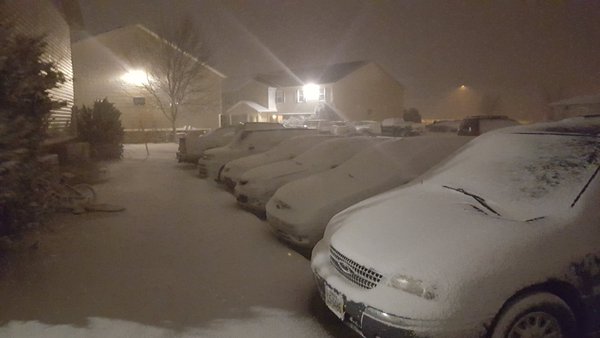
Below are a few photos we recieved from within our coverage area, most of which were sent to our Facebook/Twitter accounts.
 |
 |
 |
| Roof blown off of the Sit N Bull Saloon in Giltner, NE (photo via social media) |
Snow in Clay Center, NE
(photo by Tirin Vance ) |
Snow in Loomis, NE
(photo by Charles Rowell) |
 |
 |
Tree blown over in Arcadia, NE.
(photo by emergency manager Scott Philbrick) |
Snow in Kearney.
(photo by Lauren Sharf) |
 |
This page was composed by the staff at the National Weather Service in Hastings, Nebraska. |
 |