Brief Overview: (** refer to the "Detailed Recap" tab below for a much more extensive narrative about this event **)
|
Rainfall Amounts:
The following table and map depicts primarily 48-hour rainfall totals for March 12-14 (from a combination of official NWS statations/cooperative observers and also CoCoRaHS observers). As shown, much of the northwestern half of our Nebraska coverage area received a widespread 2-3" of rain, with a small area of 3+ inches.
|

|
Snowfall Amounts:
The following table and map depicts snow totals, most all of which fell between the night of March 13th and the morning of March 14th (from a combination of official NWS statations/cooperative observers and also CoCoRaHS observers). Although the vast majority of affected areas received less than 3", blizzard/near-blizzard conditions were common given widespread wind gusts of 50-60 MPH.
|

|
Peak Wind Gusts:
Here is a list of peak northerly wind gusts, most of which occurred during the pre-dawn and morning hours of the 14th. In several places, these strong winds promoted blowing snow and blizzard/near-blizzard conditions. PLEASE NOTE: non-airport sites are primarily unofficial, personally-owned weather stations.
|
|
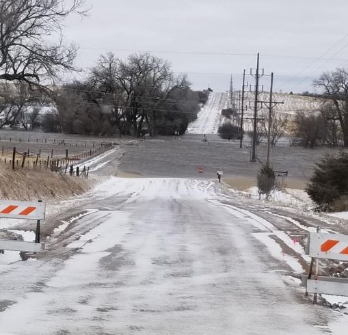
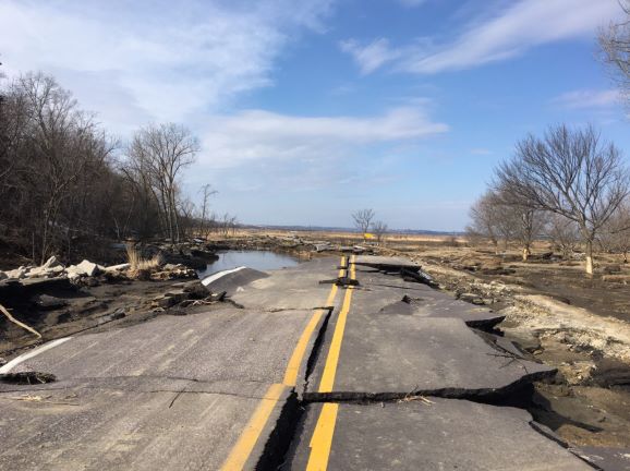
Photos:
Although these photos only reveal a small "snapshot" of the total flooding impacts across our coverage area, they represent some of the worst and/or most dramatic flooding:
 |
 |
 |
 |
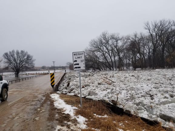
| HWY 39 bridge south of Genoa. Photo from the State of Nebraska. |
HWY 39 bridge south of Genoa. Photo from the State of Nebraska. |
Loup Canal breach southwest of Genoa. Photo from NWS Hastings. |
|
 |
 |
 |
 |
| Loup Canal breach southwest of Genoa & ice piled up next to the Loup Canal bridge south of Genoa. Photo from NWS Hastings. |
Loup Canal ice south of Genoa. Photo from Bailey Oberhauser. |
||
 |
 |
 |
 |
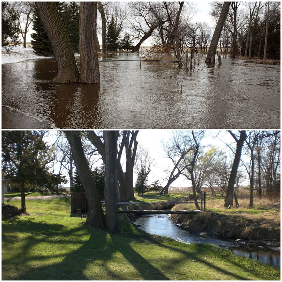
| Near Fullerton, looking toward Cedar River. Photo from Brianna Rice. | After the water receded from left photo. Photo by NWS Hastings. | Highway 14 south of Fullerton. Photo from Nebraska State Patrol. |
|
 |
 |
 |
 |
| Highway 14 south of Fullerton. Photo from Nebraska State Patrol. |
Ice piled up against a bridge south of Belgrade. Photo from Denise Ziemba. |
Road damage south of Arcadia. Photo from Sarah Forbes. |
|
 |
 |
 |
 |
| Flooding in & around Gibbon. Photo from Buffalo County Sheriff Office. |
Looking east on Highway 30 - Gibbon. Photo from Buffalo County Sheriff Office. |
North Loup Photo by Justin Wadkins Meyer. |
|
 |
 |
 |
 |
| Wood River Photo from Alma Gutierrez. |
Wood River Photo from Faith Young. |
Wood River Photo from Hall County Sheriff. |
Wood River Photo from Erin Collins. |
 |
 |
 |
 |
| Dannebrog Photo from City Dannebrog. |
Dannebrog Photo from Bob Geiger. |
South of Boelus. Photo from Scott Reynolds. |
East of Boelus. Photo from Merl Heinlein. |
 |
 |
 |
 |
| Ice chunks near Elba. Photo from Nebraska National Guard. |
Archer Photo from Carissa Soukup. |
West of Scotia. Photo from Scott Philbrick. |
|
 |
 |
 |
 |
| Northwest of Lexington. Photo from Lindsey Johanson. |
Muddy Creek near Ravenna. Photo from Chris Basnett. |
Pleasanton Photo from Seth Kucera. |
Pleasanton Photo from Michael Unick. |
 |
 |
 |
| Dam failure near Ord. Photo from State of Nebraska. |
Ice on the North Loup River near Ord. Photo by NWS Hastings. |
|
 |
 |
 |
 |
| South of Litchfield. Photo from Dianna Schukei. |
Highway 2 near Litchfield. Photo from Dianna Schukei. |
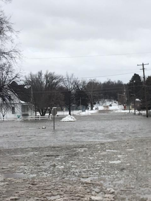
Highway 81/92 west of Osceola. Photo from John McKinney. |
Flooding south of Osceola. Photo from Melissa Gabel. |
 |
 |
 |
| Interstate 80 interchange at Highway 281. Photo from John Sidle. |
Highway 2 and Airport Road. Photo from Jon Rosenlund. |
Airport Road and Monitor Road. Photo from Jon Rosenlund. |
 |
 |
 |
| Road damage between Uehling and Oakland. Photo from @LizUehling. |
Highway 21 northeast of Oconto. Photo from Nebraska State Patrol. |
|
 |
 |
 |
| Near the Niobrara River. Photo by Sarah Sell. |
Highway 12 east of Niobrara. Photo from Nebraska State Patrol. |
Near the Niobrara River. Photo from Nebraska State Patrol. |
 |
 |
 |
 |
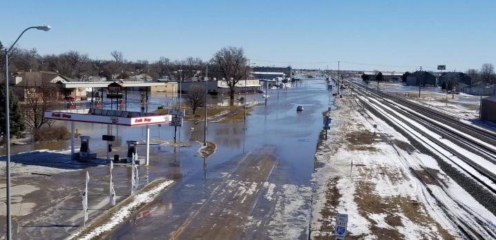
| Looking north into Columbus. Photo from Jeff Berggren. |
Near Columbus. Photo from Nebraska State Patrol. |
Near Fremont. Photo from AP - Nati Harnik. |
|
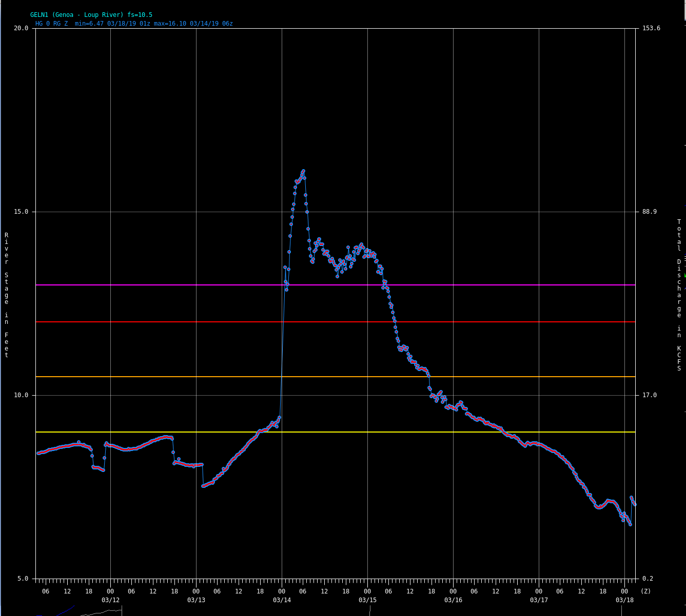
Hydrographs & Record Crests:
The table below shows PRELIMINARY new record crests from around the area:
| Location | New Record Crest/Date | Old Record Crest/Date |
| Turkey Creek Near Dannebrog | 21.21 ft - March 14th | 19.26 ft - June 12th, 1984 |
| Loup River Near Genoa | 16.1 ft - March 14th | 13.9 ft - August 13th, 1966 |
| North Loup River At Ord | 8.27 ft - March 13th | 6.58 ft - June 10th, 2010 |
| Wood River Near Gibbon | 17.4 ft - March 14th | 16.79 ft - June 15th, 1967 |
| North Loup River At St. Paul | 11.9 ft - March 14th | 9.6 ft - June 22nd, 1947 |
| Wood River Diversion Grand Island | 18.15 ft - March 17th | 17.1 ft - June 8th, 2008 |
The images below show hydrographs (graphs showing the river level over time) from most of the rivers listed in the above table.
The river level (in feet) is shown on the left, with date/time (time is in UTC time) at the bottom.
The orange horizontal line is "Minor Flood Stage", the red line is "Moderate Flood Stage", and the pink line is "Major Flood Stage".
 |
 |
 |
 |
 |
| Turkey Creek Near Dannebrog |
Loup River Near Genoa |
North Loup River At Ord |
Wood River Near Gibbon |
North Loup River At St. Paul |
The table below shows PRELIMINARY peak (non-record breaking) crests from around the area:
| Location | Peak Crest/Date |
| Wood River Near Alda | 13.61 ft - March 16th (3rd highest) |
| Mud Creek Near Sweetwater | 21.95 ft - March 14th (2nd highest) |
| Cedar River Near Fullerton | 15.99 ft - March 14th (2nd highest) |
Detailed Recap:
 |
 |
| 500 mb - Upper Air Map Valid for 7 p.m. CDT March 13th |
Surface Analysis Map Valid for 7 p.m. CDT March 13th |
Excessive rainfall, blizzard conditions, and high winds occurred on this Tuesday night, Wednesday and Thursday, and they were followed by extensive and significant flooding that lasted for days afterward. The seeds of the disastrous flooding were planted in the weeks leading up to this event. The factors that came together made this a worst case scenario. February through early March was bitterly cold and snowy due to a blocking ridge between Alaska and Hawaii and the downstream trough along the West Coast of the United States. The 32-day stretch from February 4th through March 7th was the third coldest on record, after 1936 and 1960. By itself, February was the coldest month in 18 years (since December 2001). Repeated snowfall events resulted in several inches of snow cover across all of south central Nebraska from the middle of February through the first 12 days of March. The deepest snow was over Valley, Greeley, Nance, and Polk counties with 10 to 17 inches on the ground. Sherman, Howard, Fillmore, and Thayer counties also had as much as 12 inches on the ground part of that time. Because of the excessive cold, extensive ice formed on all rivers and creeks, and the ground was frozen to a depth of 25 inches.
On Monday and Tuesday (March 11th and 12th), a low pressure system progressed through Arizona and New Mexico. Tuesday night, this low began rapidly deepening and, in just 15 h, it deepened 24 mb from 994 mb to 970 mb. This low broke the all-time sea-level pressure record for the state of Colorado, with 970.4 mb at Lamar. The previous record was 975.0 mb on March 13, 1973. Precipitation over south central Nebraska fell in three periods. Scattered showers and thunderstorms first moved in Tuesday night followed by a large shield of stratiform rain Wednesday morning. Wednesday afternoon was predominantly dry as that area of rain lifted to the north and east. As the low advanced into Kansas, with a pressure of 975 mb, the warm occluded front moved north into south central Nebraska, along with the dry slot. Temperatures surged into the 50s and 60s. However, Arctic air was pouring into Nebraska on the cold side of the front. As destabilization occurred with daytime heating, rain developed and blossomed around the upper low. As this low moved into eastern Nebraska Wednesday night, the relatively small comma-shaped area of rain moved into south central Nebraska. For several hours, the deformation zone stalled along and west of Highway 281, further increasing rainfall totals. As cold air advection cooled the lower troposphere, the rain changed to snow. Thursday morning this area of snow moved to the east of Highway 281 and dissipated by midday. By sunrise Thursday, the surface low had filled, but was still 984 mb over western Iowa, with a 32 mb pressure gradient across Nebraska. High winds combined to produce blizzard conditions Thursday morning.
Widespread high winds occurred between 12 AM and 1 PM CST March 14th. Many locations gusted to 58 mph. The highest wind gusts included 68 mph at Ord, 67 at Cozad, 66 at Cambridge, 64 at Hastings, 63 at Grand Island and Johnson Lake, and 62 at Wood River and Ravenna. There were 18 gusts of 58 mph or more at the airport in Ord. Tree branches were snapped off nearby in Arcadia. Isolated power outages occurred due to a combination of the high winds and flooding.
Precipitation amounts from 8 AM CST on the 12th through 8 AM CST on the 14th were between 2 and almost 4 inches northwest of a line from Beaver City to Grand Island to Fullerton. Most of that fell as rain. The highest 48 hr precipitation amounts were 3.82 inches at St. Libory, 3.58 at St. Paul, 3.52 near Elba, 3.46 at Spalding, 3.12 at Greeley, 3.10 at Cairo, and 3.02 at Holdrege.
Snowfall amounts were generally 1 to 2 inches along and west of Highway 281, but a few locations were close to 3 inches. Kearney measured 3.2 inches, while Franklin, and Cairo measured 3.0, with 2.7 inches was measured in Arcadia. Despite the low amounts, blizzard conditions were fierce and were not depicted well by visibility sensors from area AWOS and ASOS stations. Visibilities were reported near zero.
The rain, combined with temperatures rising above freezing on the 12th, and remaining above freezing through the daylight hours of the 13th, including during the preceding night, resulted in very rapid snowmelt. In 48 hours, the snow depth at Greeley dropped from 10 inches to 2. At Arcadia, the snow depth dropped from 8 inches to 1. With the ground frozen, the water converted entirely to run-off. This resulted in the worst flooding in decades and, in some locations, the worst on record. The flooding was most widespread and damaging north of the Platte River. The flooding began Wednesday morning. Rivers and creeks and all their tributaries overflowed. This included the Wood River, the entire Loup River system, and the Cedar River. All low-lying areas were covered in water. Numerous Flood Warnings were issued and, by Wednesday night, the flooding was so widespread, that warnings covered all of south central Nebraska. In fact, Flash Flood Warnings were in effect at the same time Blizzard Warnings were in effect. Evacuations by boat were occurring in blizzard conditions the morning of the 14th. Due to the combination of flooding and blizzard conditions, many churches cancelled events on the 13th and 14th, and most schools cancelled classes on the 14th. Classes were also cancelled at all Central Community Colleges in Grand Island, Kearney, Hastings, Ord, Lexington, and Holdrege.
Widespread flash flooding occurred the night of Wednesday March 13th into Thursday the 14th. People were trapped in vehicles Wednesday evening after driving into flood waters on roads that crossed the Wood River in Buffalo county. Multiple rescues were necessary. Two cars were swept off the road into the swollen Wood River north of Kearney. One woman waited for a rescue team on the roof of her car. She was rescued using a jetski. A man was also rescued from a semi that was swamped by flood waters. The Loup Power Canal intake was overtopped by flood waters in Nance county. The Loup Power District enacted their emergency action plan necessitating the evacuation of the south side of Genoa. The hospital and nursing home were also evacuated. Highways were already closed in the area which complicated the evacuation. The Highway 22 bridge over the Loup canal was washed out at both ends, and a large break occurred on one side of the canal itself. A home was also swept away in the North Loup River just north of St. Paul.
The impacts from this flooding were so immense, that it is impossible to document them all. Rivers and fields looked like lakes. Water covered hundreds of gravel and paved roads, including state and federal highways, making them impassable. Hundreds of roads were washed out or severely damaged, including some state and federal highways. U.S. Highway 30 was closed in both directions between Shelton and Alda due to flooding of the Wood River. Water 1 to 2 ft deep covered Highway 30 in Gibbon. Highway 30 was also closed from Silver Creek to Highway 81 due to flooding. Some of the most extensive damage to paved roads occurred to state Highways 14, 22, and 39 in Nance county. State Highway 14 was severely damaged with large chunks of pavement caved-in after the ground underneath was eroded away by swiftly moving water. In Hall county, 163 of the gravel roads were damaged. Preliminary cost estimates for repairing them was $2-3 million, with $700-800,000 to repair paved roads. The preliminary estimated cost to damaged roads and bridges in Buffalo county was $1.5-2 million. At the peak of the flooding, so many roads were closed that Buffalo, Dawson, Howard, Phelps, and Sherman counties ran out of barricades. While flooding was most widespread and damaging north of Interstate 80, minor flooding also occurred in Gosper, Furnas, Phelps,Harlan, Kearney, Adams, Franklin, Webster, Nuckolls, Thayer, and Fillmore counties.
Dozens of bridges were washed out, primarily on county roads. Most of the washed out bridges were over creeks on gravel roads, but one was across the Middle Loup River south of Boelus. Bridges on paved roads were also affected. The bridge on state Highway 39, across the Loup River south of Genoa, was also washed out. Where bridges weren’t washed out severe erosion occurred to the abutments, even on some railroad bridges. Thirty-seven bridges were damaged just in Howard county.
As increasing flows on area rivers broke up the ice, ice jams occurred on the Middle Loup River near Arcadia and southeast of Rockville, on the Cedar River near Belgrade, on the upstream side of the Highway 14 bridge in Nance county, north of Fullerton. An ice jam on the upstream side of the bridge over Mud Creek, near Ravenna, was broken up by an excavator. Large slabs of ice were also deposited and jaggedly piled-up by flood waters onto bridges and adjacent road leading up to the bridges. Just south of Fullerton, ice covered the Highway 14 bridge over the Loup River, keeping it impassable even after flood waters receded. Flood waters on the Middle Loup River deposited slabs of ice the size of pickup trucks onto the Highway 68 bridge at Rockville.
Thousands of homes and businesses were damaged. Flooding was extensive in Dannebrog, Pleasanton, Gibbon, Wood River, and Alda. In the town of Wood River, water was 3 to 4 ft deep between 11th and 13th streets. Water was 5 to 6 ft deep in parts of Dannebrog. Ninety percent of that town was evacuated and the sewer system was shutdown. Post offices at Dannebrog, Elba, and Pleasanton were temporarily evacuated with mail operations moved to nearby post offices. People were evacuated in Belgrade, Dannebrog, Genoa, Gibbon, North Loup, Pleasanton, Shelton, and Wood River, some even by boat. Red Cross shelters were opened in North Loup, Boelus, and at the high school in Wood River.
Trains were also severely impacted. The Union Pacific (UP) railroad tracks between Gibbon and Columbus were shut down for several days. Rushing water eroded and washed out the bed underneath all 3 tracks in Gibbon. Six UP trains were parked at Central City and Clarks because they were unable to continue to their destinations. The Burlington Northern Santa Fe (BNSF) rail line from Litchfield to Ravenna to York was also shutdown for several days. Several miles of BNSF track was also damaged between Gibbon and Alexandria due to flooding along the Little Blue River. Options for rerouting trains was limited because the flooding was so widespread over eastern Nebraska and western Iowa. Ethanol plants in Ravenna, Ord, and Central City were impacted and could not get ethanol to market because of damaged tracks. Passenger trains were also affected. The Amtrak trains that travel between Emeryville, CA and Chicago, IL were stopped in Denver and unable to make the trip east. Amtrak normally has scheduled stops at Holdrege and Hastings.
Record crests occurred on several creeks and rivers. The Turkey Creek at Dannebrog set a new record at 21.21 ft. The old record was 19.26 ft from June 12, 1984. The Loup River at Genoa set a new record at 16.10 ft. The old record was 13.9 ft on August 13, 1966. The North Loup River at Ord set a new record at 8.27 ft. The old record was 6.85 on June 10, 2010. At St. Paul, the North Loup River set a new record at 11.9 ft. The old record was 9.6 ft on June 22, 1947. The Wood River at Gibbon set a new record at 17.4 ft. The old record was 16.79 ft on June 15, 1967. Other significant river levels occur on the Wood River at Alda. The crest of 13.61 ft was the third highest on record behind 1967 and 2005. Mud Creek, just west of Ravenna, crested at 21.95 ft. This was the second highest crest behind 1947. The Cedar River at Fullerton crested at 15.99 ft which was the second highest behind 1966.
Despite the major flooding that occurred on the Wood River, from Gibbon to Alda, the Wood River Diversion at Grand Island worked as designed and protected the south side of Grand Island from flooding. A new record water level was set at the Wood River Diversion, though. Water crested at 18.15 ft which was higher than the 17.10 ft that occurred on June 8, 2008. The Wood River Diversion was completed in May 2004.
Impacts to agriculture were tremendous. As flood waters receded, pasture land and fields next to rivers and creeks were covered in inches of sand and silt. This flooding occurred in the middle of calving season. Hundreds of calves perished. Some reported livestock carcasses floating away. In some locations, cattle were isolated on islands. This combined with numerous damaged or flooded roads made travel to and around some farms impossible. Farmers in other parts of the country responded. Truckloads of hay were brought to Grand Island and staged at Fonner Park, from within the state, and from as far away as Ohio. One convoy of nine trucks delivered 200 tons of hay from Dickenson, ND to Fullerton. Hay also came from northwest Ohio to Pleasanton. Grain was also donated from farms in Ohio. Similar to the aftermath of the blizzard of January 1949, hay was airlifted by helicopters, from Fonner park, to stranded cattle in parts of Nance, Greeley, and surrounding counties.
Flooding continued until Saturday, March 23rd. Water levels gradually fell between the 15th and 23rd, with flooded areas decreasing. The most widespread flooding occurred from the 14th to the 18th, with major flooding (based on flood stage level) along the Wood River in Buffalo and Hall counties, the North Loup river, the Loup River, the Platte River from Grand Island along the Hamilton-Merrick county line, and minor flooding on the Middle and South Loup Rivers, the Cedar River in Nance county, the Republican River in Harlan, Nuckolls and Webster counties, and the Little Blue River in Clay and Nuckolls counties.
On Tuesday the 12th, Governor Pete Ricketts declared a state of emergency for the entire state in anticipation of the severe weather. In advance of the heavy snow that was forecast to fall from the Sandhills into western Nebraska, the Nebraska Department of Transportation preemptively closed Interstate 80 from Lexington west to the Wyoming border. Once travelers and trucks began filling up hotels and parking areas in Kearney, I-80 was closed all the way east to Grand Island. Highway 30 was also closed from Kearney west to the Wyoming border.
Due to the magnitude of the flooding in central and eastern Nebraska, the State Emergency Operations Center was activated. Emergencies were declared by most counties in south central Nebraska. Governor Ricketts applied for and received a federal disaster declaration for Adams, Buffalo, Fillmore, Furnas, Gosper, Greeley, Hall, Harlan, Howard, Merrick, Nance, Nuckolls, Sherman, Thayer, Valley, and York counties.
Damage estimates of property, buildings, roads, bridges, loss of livestock and stored crops, will not be fully assessed as of this writing. Preliminary estimates of damage to the entire state of Nebraska were expected to be more than $1 billion.
 |
Media use of NWS Web News Stories is encouraged! Please acknowledge the NWS as the source of any news information accessed from this site. |
|


