Overview/Narrative:
(BE SURE TO CLICK THE VARIOUS TABS BELOW FOR A VARIETY OF MARCH 2018 CLIMATE INFORMATION!)
|
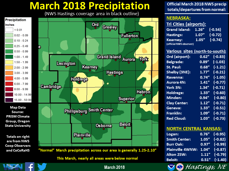
Recap of March 2018 Weather for the 30-county NWS Hastings Coverage Area:
|
Grand Island & Hastings Details (Including 12-Month History):
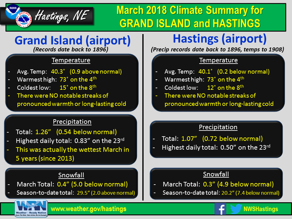 |
| Detailed March 2018 info for Grand Island/Hastings (Click to enlarge) |
 |
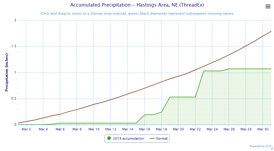 |
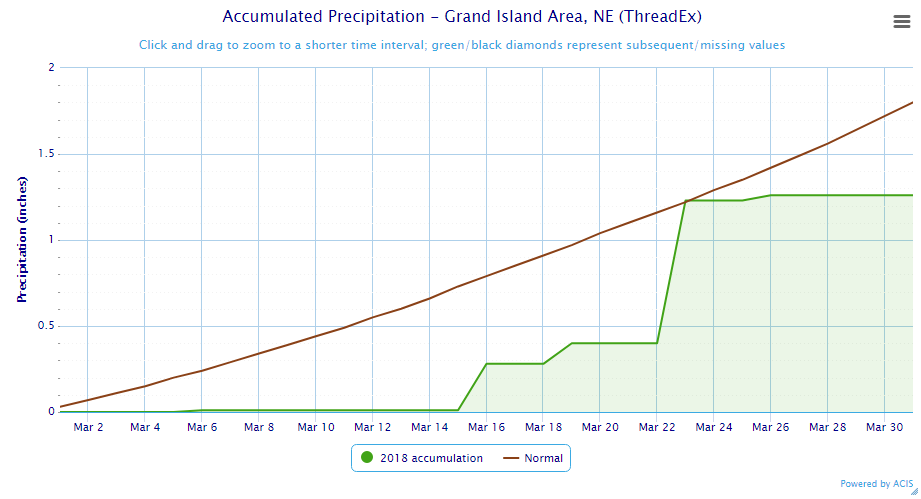
| Grand Island Precipitation Summary: The green line indicates cumulative observed precipitation for March 2018.The brown line indicates "normal" March precipitation based on 30-year data from 1981-2010. (click to enlarge) | Hastings Precipitation Summary: The green line indicates cumulative observed precipitation for March 2018. The brown line indicates "normal" March precipitation based on 30-year data from 1981-2010. (click to enlarge) |
| Grand Island (Regional Airport ASOS) - Apr. 2017 - Mar. 2018 | ||||||||||||
| Apr. | May | June | July | Aug. | Sep. | Oct. | Nov. | Dec. | Jan. | Feb. | Mar. | |
| Average High (F) | 63.1 | 72.7 | 87.5 | 88.9 | 81.3 | 80.5 | 65.2 | 53.4 | 37.3 | 34.0 | 33.6 | 51.8 |
| Average Low (F) | 39.2 | 49.6 | 61.2 | 66.6 | 58.9 | 55.0 | 40.2 | 28.7 | 16.0 | 13.5 | 12.5 | 28.8 |
| Average Temperature (F) | 51.1 | 60.3 | 74.4 | 77.8 | 70.1 | 67.8 | 52.7 | 41.1 | 26.6 | 23.7 | 23.1 | 40.3 |
| Departure From Normal | +0.5 | -0.9 | +3.1 | +1.6 | -3.9 | +2.7 | +0.5 | +3.0 | -0.1 | -1.4 | -6.0 | +0.9 |
| Precipitation (in) | 2.64 | 5.28 | 2.10 | 3.05 | 6.19 | 2.68 | 5.36 | 0.51 | 0.45 | 1.08 | 0.75 | 1.26 |
| Departure From Normal | +0.11 | +0.87 | -2.20 | -0.35 | +3.07 | +0.45 | +3.50 | -0.66 | -0.18 | +0.55 | +0.07 | -0.54 |
| Snowfall (in) | T | 0.3 | 0.0 | 0.0 | 0.0 | 0.0 | 0.9 | 0.2 | 7.2 | 10.2 | 10.6 | 0.4 |
| Departure From Normal | -1.5 | +0.3 | 0.0 | 0.0 | 0.0 | -0.1 | -0.1 | -2.9 | +2.1 | +3.7 | +4.3 | -5.0 |
| Hastings (Municipal Airport ASOS) - Apr. 2017 - Mar. 2018 | ||||||||||||
| Apr. | May | June | July | Aug. | Sep. | Oct. | Nov. | Dec. | Jan. | Feb. | Mar. | |
| Average High (F) | 63.4 | 72.8 | 86.3 | 88.9 | 81.7 | 81.2 | 64.9 | 53.1 | 37.9 | 35.3 | 34.3 | 52.3 |
| Average Low (F) | 40.7 | 49.5 | 62.1 | 67.6 | 59.8 | 55.9 | 40.8 | 28.6 | 15.9 | 14.3 | 12.4 | 27.8 |
| Average Temperature (F) | 52.1 | 61.1 | 74.2 | 78.2 | 70.7 | 68.6 | 52.9 | 40.9 | 26.9 | 24.8 | 23.4 | 40.1 |
| Departure From Normal | +1.4 | -0.2 | +2.4 | +1.1 | -3.6 | +3.0 | +0.3 | +2.2 | -0.7 | -1.2 | -6.5 | +0.2 |
| Precipitation (in) | 3.24 | 6.42 | 1.79 | 4.71 | 5.10 | 2.18 | 4.69 | 0.08 | 0.28 | 0.49 | 0.53 | 1.07 |
| Departure From Normal | +0.68 | +1.85 | -2.01 | +0.97 | +1.80 | -0.38 | +2.70 | -1.21 | -0.33 | +0.08 | +0.04 | -0.72 |
| Snowfall (in) | 0.2 | 0.6 | 0.0 | 0.0 | 0.0 | 0.0 | 0.2 | 0.0 | 5.8 | 5.9 | 8.0 | 0.3 |
| Departure From Normal | -1.0 | +0.6 | 0.0 | 0.0 | 0.0 | -0.2 | -1.0 | -2.6 | -0.3 | -0.1 | +1.5 | -4.9 |
Kearney - 12 Month Climate History:
All data here is from the official NWS observer at Kearney airport, with 24-hour observations taken around 7 a.m. ** PLEASE NOTE: This official Kearney data often differs at least slightly from the unofficial data recorded by the automated airport system (KEAR) **
| Kearney Airport (Coop Observer) - Apr. 2017 - Mar. 2018 | ||||||||||||
| Apr. | May | June | July | Aug. | Sep. | Oct. | Nov. | Dec. | Jan. | Feb. | Mar. | |
| Average High (F) | 62.5 | 70.2 | 86.6 | 88.1 | 81.2 | 80.7 | 65.9 | 52.3 | 38.7 | 32.2 | 32.9 | 51.9 |
| Average Low (F) | 38.8 | 45.9 | 59.7 | 64.8 | 56.9 | 52.6 | 40.0 | 26.8 | 15.5 | 11.1 | 10.6 | 26.1 |
| Average Temperature (F) | 50.7 | 58.1 | 73.2 | 76.5 | 69.1 | 66.6 | 53.0 | 39.6 | 27.1 | 21.6 | 21.7 | 39.0 |
| Departure From Normal | +2.0 | -1.4 | +3.4 | +1.8 | -3.5 | +3.1 | +2.1 | +2.6 | +1.2 | -3.0 | -6.4 | +1.3 |
| Precipitation (in) | 1.87 | 6.03 | 1.93 | 3.66 | 3.65 | 2.19 | 2.83 | 0.34 | 0.21 | 0.96 | 0.73 | 1.05 |
| Departure From Normal (in) | -0.36 | +1.85 | -2.00 | +0.38 | +0.57 | +0.12 | +0.79 | -0.68 | -0.36 | +0.47 | +0.18 | -0.74 |
| Snowfall (in) | T | 1.6 | 0.0 | 0.0 | 0.0 | 0.0 | 0.0 | 0.4 | 4.3 | 6.8 | 9.2 | 0.7 |
| Departure From Normal (in) | -1.8 | +1.6 | 0.0 | 0.0 | 0.0 | -0.2 | -0.7 | -2.7 | +0.8 | +2.4 | +4.1 | -3.9 |
Ord - 12 Month Climate History:
Winter precipitation totals often include NWS Cooperative Observer data due to the automated airport equipment under-measuring snowfall liquid equivalent.
| Ord (Evelyn Sharp Field ASOS) - Apr. 2017 - Mar. 2018 | ||||||||||||
| Apr. | May | June | July | Aug. | Sep. | Oct. | Nov. | Dec. | Jan. | Feb. | Mar. | |
| Average High (F) | 61.7 | 69.7 | 86.3 | 90.3 | 81.4 | 78.0 | 63.7 | 53.4 | 36.6 | 34.3 | 31.2 | 49.9 |
| Average Low (F) | 37.9 | 44.1 | 56.9 | 64.1 | 56.3 | 51.2 | 36.1 | 24.3 | 14.1 | 10.2 | 9.0 | 25.5 |
| Average Temperature (F) | 49.8 | 56.9 | 71.6 | 77.2 | 68.8 | 64.6 | 49.9 | 38.9 | 25.3 | 22.2 | 20.1 | 37.7 |
| Departure From Normal | +1.0 | -2.4 | +2.4 | +2.8 | -4.2 | +1.0 | +0.3 | +2.6 | +0.4 | -2.4 | -7.7 | 0.0 |
| Precipitation (in) | 4.25 | 3.10 | 0.59 | 2.53 | 5.93 | 2.89 | 5.37 | 0.21 | 0.43 | 0.83 | 0.53 | 0.62 |
| Departure From Normal (in) | +1.66 | -0.71 | -3.53 | -0.44 | +2.77 | +0.45 | +3.44 | -0.86 | -0.16 | +0.46 | +0.09 | -0.83 |
| Snowfall (in) | 1.0 | 6.0 | 0.0 | 0.0 | 0.0 | 0.0 | 0.0 | 2.0 | 5.3 | 12.4 | 8.6 | 1.1 |
| Departure From Normal (in) | -1.5 | +6.0 | 0.0 | 0.0 | 0.0 | 0.0 | -1.1 | -3.3 | -2.1 | +5.6 | +2.6 | -4.8 |
Smith Center, KS - 12 Month Climate History:
All data is from the official NWS observer, with 24-hour observations taken around 7 a.m. As a result, data may vary slightly from true "Calendar Day" totals.
| Smith Center KS (NWS Coop Observer) - Apr. 2017 - Mar. 2018 | ||||||||||||
| Apr. | May | June | July | Aug. | Sep. | Oct. | Nov. | Dec. | Jan. | Feb. | Mar. | |
| Average High (F) | 65.4 | 73.9 | 89.8 | 95.2 | 86.4 | 85.6 | 70.5 | 55.9 | 43.6 | 39.1 | 39.4 | 57.8 |
| Average Low (F) | 40.0 | 46.8 | 60.9 | 66.7 | 59.9 | 56.0 | 40.1 | 28.5 | 17.6 | 12.6 | 13.5 | 27.9 |
| Average Temperature (F) | 52.7 | 60.4 | 75.4 | 80.9 | 73.1 | 70.8 | 55.7 | 42.2 | 30.6 | 25.9 | 26.4 | 42.8 |
| Departure From Normal | +0.2 | -3.3 | +1.4 | +1.2 | -4.1 | +2.6 | +0.9 | +1.8 | +1.8 | -1.8 | -5.6 | +1.2 |
| Precipitation (in) | 3.32 | 7.03 | 1.31 | 3.26 | 2.05 | 2.67 | 1.36 | 0.09 | 0.11 | 0.32 | 0.31 | 1.05 |
| Departure From Normal (in) | +1.05 | +3.11 | -2.30 | -0.61 | -1.25 | +0.63 | -0.52 | -1.13 | -0.55 | -0.17 | -0.27 | -0.82 |
| Snowfall (in) | 0.0 | 0.0 | 0.0 | 0.0 | 0.0 | 0.0 | 0.0 | 0.2 | 2.0 | 3.5 | 7.6 | T |
| Departure From Normal (in) | -0.6 | 0.0 | 0.0 | 0.0 | 0.0 | -0.2 | -0.4 | -1.6 | -1.2 | -0.2 | +3.5 | -2.6 |
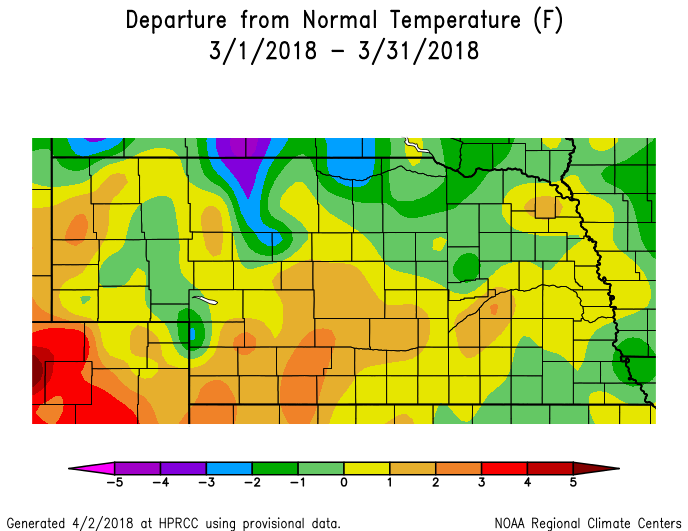
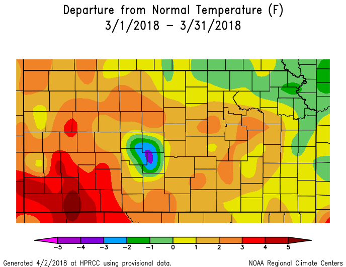
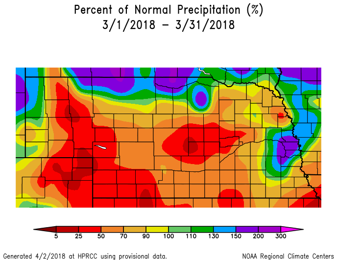
Temperature & Precipitation Departure From Normal Maps:
These images depict March 2018 monthly temperature departure from normal & precipitation percent-of-normal for both Nebraska & Kansas. Images are courtesy of the High Plains Regional Climate Center (HPRCC). Please note: These maps occasionally contain "bullseyes" of errant data. For precipitation, you can also generate departure from normal/percent-of-normal maps using the NWS AHPS page
 |
 |
 |
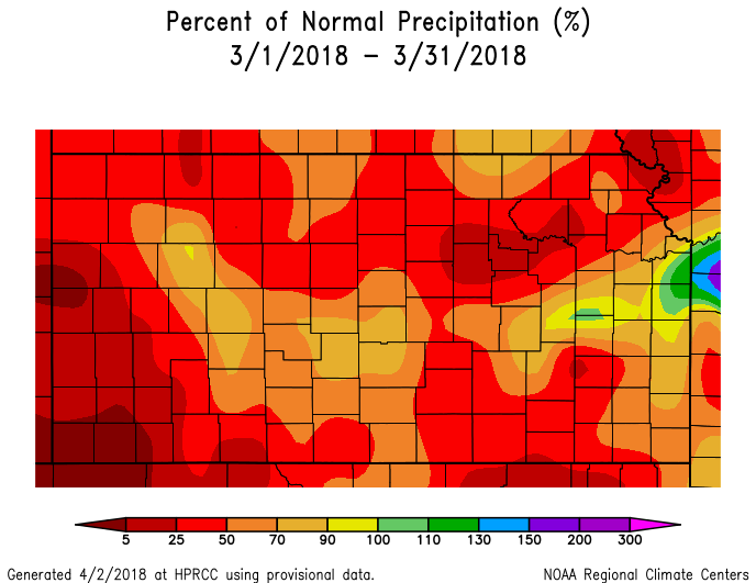 |
| Departure from Normal Temperature - NE (left) & KS (right) | Percent of Normal Precipitation - NE (left) & KS (right) | ||
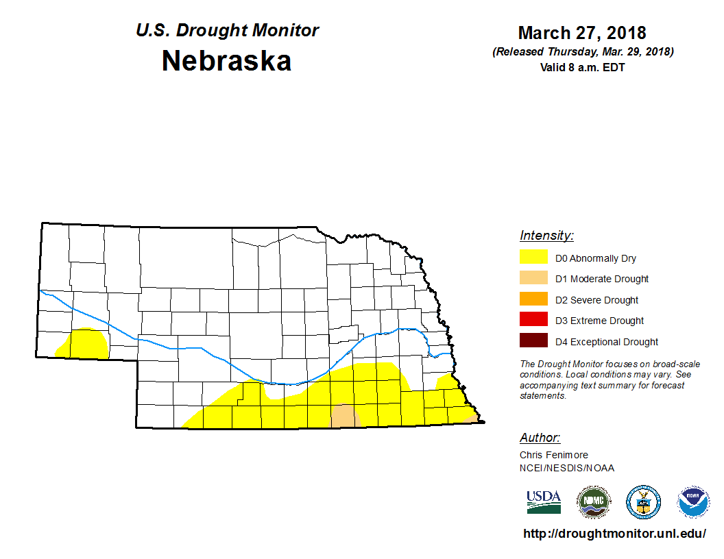
Drought:
The following drought images, current as of March 27, 2018, are courtesy of the U.S. Drought Monitor
Brief summary of changes during March across the NWS Hastings coverage area:
Although nearly the entire NWS Hastings coverage area observed below normal March precipitation, rains were "just sufficient enough" to keep a major degradation in drought categories at bay. That being said, things did become a little worse, especially in the north central Kansas counties where a bit more of the area degraded to Moderate Drought (category D1), with Severe Drought (D2) barely holding off to the south along Interstate 70. On the Nebraska side, Moderate Drought crept into mainly Nuckolls County, but the vast majority of the area continued with either Abnormally Dry (D0) or no drought categories whatsoever (mainly north of Interstate 80).
 |
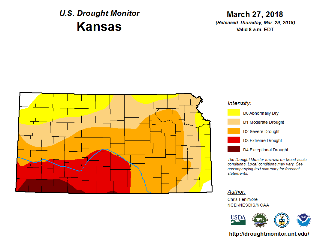 |
| Drought Monitor for Nebraska (left) & Kansas (right). Valid as of March 27, 2018 (click to enlarge) | |
Monthly Extremes for the NWS Hastings Coverage Area:
...A FEW OF THE WARMEST HIGH TEMPERATURES DURING MARCH 2018...
(all data from NWS cooperative observers or automated airport sites, with the date indicated in parentheses)
81 degrees...4WNW Plainville KS (on the 4th)
81 degrees...2SW Alton KS (4th)
80 degrees...Webster Dam KS (4th)
79 degrees...Beaver City (3rd) - Smith Center KS (4th)
...A FEW OF THE COLDEST LOW TEMPERATURES DURING MARCH 2018...
(all data from NWS cooperative observers or automated airport sites, and all occurred on the 8th)
5 degrees...Red Cloud
7 degrees...2SW Alton KS
9 degrees...Webster Dam KS - Beaver City - 6NNW Oxford - Ord airport - Superior - Hebron
...A FEW OF THE HIGHEST MONTHLY PRECIPITATION TOTALS DURING MARCH 2018...
(all data from NWS cooperative observers and CoCoRaHS/NeRAIN observers unless indicated)
1.95"...Osceola
1.87"...Wilcox
1.80"...3W Gresham
1.77"...3NE Shelby
1.71"...4E Waco
...A FEW OF THE LOWEST MONTHLY PRECIPITATION TOTALS DURING MARCH 2018...
(all data from NWS cooperative observers and CoCoRaHS/NeRAIN observers unless indicated)
0.31"...Cozad
0.34"...Gothenburg
0.41"...Loup City
0.46"...2NW Rockville
0.51"...Beloit KS
...A FEW OF THE HIGHEST MONTHLY SNOWFALL TOTALS DURING MARCH 2018...
(all data from NWS cooperative observers unless indicated)
6.0"...Holdrege
4.0"...Minden
3.2"...8S Elwood
2.7"...Osceola - 3NE Shelby
2.3"...4WNW Plainville KS
 |
Media use of NWS Web News Stories is encouraged! Please acknowledge the NWS as the source of any news information accessed from this site. |
|