Brief Summary:
(see tabs below for much more, including full narrative and graphics!)
More than anything else, January 2019 was highlighted by a sharp divide in precipitation/snowfall amounts, as roughly the northwest 2/3 of the area was quite dry, while roughly the southeast 1/3 (including north central KS) was considerably wetter, with snow totals of 6-12" common.Temperature-wise, the first half of the month was considerably warmer than the second half, but the month as a whole only averaged 0-2º above normal. (See full narrative in tabs below for much more detail!)
NOTE: Information in this story is exclusively for the 30-county NWS Hastings Coverage Area
2018 Nebraska Cooperative Observer Precipitation Tables (around 45 sites) |
Narrative
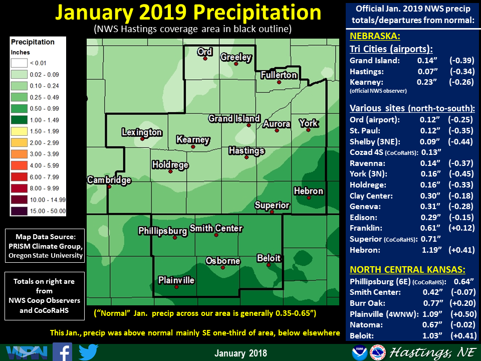
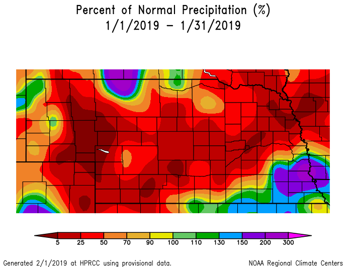
- Precipitation (rainfall+snow liquid...see map at top of story): Clearly the main highlight of Jan. 2019 precipitation was the SHARP DIVIDE between roughly the northwest two-thirds of the area (quite dry) and roughly the southeast one-third (including north central KS), which was considerably wetter. More specifically, this "breakpoint" resided generally along a line from Alma-Red Cloud-Fairmont. To the southeast of this line, mainly above normal monthly totals of 0.50-1.00" (and isolated higher) were common, with the majority of this precipitation associated with a heavier-than-expected snow event on the 11th-12th (see separate snow section below). In sharp contrast, for most locations northwest of the aforementioned line (including the Nebraska Tri Cities), totals of no more than 0.10-0.30" were common, with localized spots even drier. In fact, at Hastings airport, the paltry total of 0.07" resulted in the 9th-driest January on record (and the driest since 1987). Per dozens of NWS/CoCoRaHS observers, a few of the highest-known January totals featured: 1.49" northeast of Natoma KS, 1.31" near Hunter KS, 1.19" at Hebron and 1.13" near Shickley. On the much drier side of things, a few of the most meager amounts included: 0.03" near Lexington, 0.04" in Doniphan and 0.06" at Hastings NWS office, Loup City, Osceola and near Scotia.
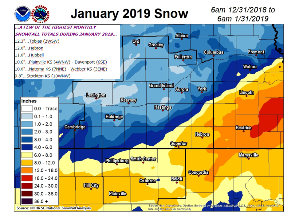
- Snowfall/Winter Weather (see snow map at top of story): Oddly, enough, snowfall during January featured nearly a complete "geographical reversal" from December. While the highest December totals targeted roughly the northwest half of the local area, the vast majority of January snow fell within the southeast one-third of the area (including north central KS). Following in line with the precipitation narrative above, there was a rather SHARP DIVIDE in snowfall amounts across the area. Generally speaking, most locations northwest of a line from Cambridge-Hastings-York recieved no more than 2" through the entire month (including the Nebraska Tri Cities). In contrast, amounts of 6-12" were common especially to the southeast of a Phillipsburg KS-Red Cloud-Fairmont line. By far the main reason for the much higher totals in southern/southeastern counties was a heavier-than-expected snow event on the 11th-12th. Per NWS/CoCoRaHS observers, a few of the highest January snow totals featured: 12.3" near Tobias (extreme eastern Fillmore County), 12.0" in Hebron, 11.0" in Hubbell and 10.6" near Davenport and also Plainville KS. Here is a brief recap of the two primary January snow events:
- 1) Jan. 11-12: See this story for much more detail, but this was by far the "main event" of the month, as a widespread 4-8" of snow targeted locations mainly south of Phillipsburg KS-Red Cloud-Geneva line.
- 2) Jan. 22-23: While the majority of the 30-county area saw no more than 1-2" of snow, mainly portions of far southeastern counties such as Thayer/Fillmore/Nuckolls/Jewell received a more widespread 2-4". However, well to the northwest of this primary "snow zone", a very narrow (10 miles wide at most) band of snow totaling as much as 3-7" fell along a line centered roughly from Cambridge-Overton (including central Gosper County).
- Flooding: As is typical in the heart of winter, the only known flooding within the area during January was fairly minor, and primarily related to ice jam issues. Flood Advisories were issued for two particular river locations during the month: 1) The Middle Loup River near Rockville, where minor flooding persisted on several days...2) The Platte River in southeastern Buffalo County, where some low-land flooding was reported near the Interstate 80 Gibbon interchange mainly from the 25th-26th.
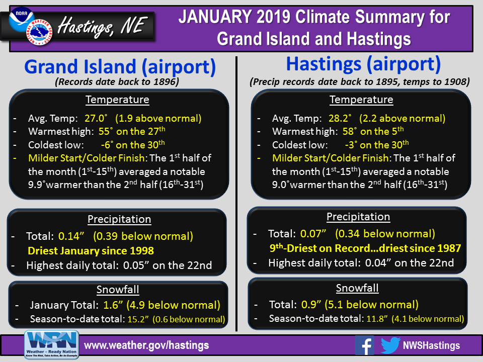
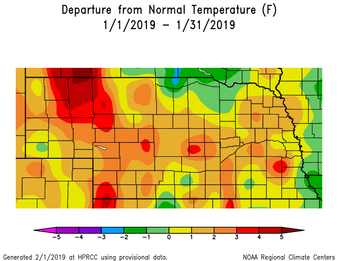
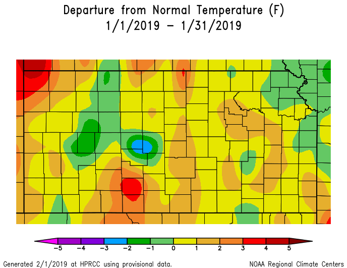
- Temperatures: January featured no truly prolonged streaks of notably warm or bitterly cold weather, and as a whole, the month in most places averaged from very-near normal to around 2º above normal. That being said, there was a noticeable disparity between the first and second halves of the month, as the first half averaged generally 5-10º milder than the second half. Interestingly, the two outright-coldest days occurred weeks apart, the first very early (New Year's Day) and the latter very late (on the 30th). Both of these days featured Wind Chill Advisories, as chills dropped into the -20 to -30º range in parts of the area. For most locations, the overall-warmest week centered between the 4th-10th, during which highs in the 40s/50s (and even a few 60s) were most common. As for monthly extremes, most official NWS observers/automated stations notched their warmest readings on either the 5th or the 27th, including the following (which all occurred on the 5th): 63º near Plainville KS, 62º at Hebron and 61º at Smith Center KS. On the much colder side of things, nearly all stations notched their most frigid lows of the winter-so far-on the morning of the 30th, highlighted by: -12º at Osceola, -9º at Greeley and near York, and -8º at Aurora airport.
- Severe Thunderstorms/Tornadoes/Severe Non-Thunderstorm Winds (for official severe storm reports refer to NCEI Storm Events Database):
- # of confirmed tornadoes during January 2019: Zero (same as 2018)
- Largest known hail stone reported to NWS Hastings: None occurred
- Strongest known measured thunderstorm wind gust: None occurred
- Strongest known measured NON-thunderstorm wind gusts: Several official and unofficial stations recorded peak northerly gusts mainly between 55-65 (isolated higher) MPH during the morning hours of Jan. 28th, in the wake of a powerful cold front passage. Peak official gusts featured: 68 MPH at Ord airport, 66 MPH at Hastings airport and 63 MPH at Grand Island airport.
- Notable wind damage reported to NWS Hastings (ground-truth reports): None reported
- # of Severe Thunderstorm Warnings issued by NWS Hastings: Zero (same as 2018)
- # of Tornado Warnings issued by NWS Hastings: Zero (same as 2018)
Grand Island & Hastings Details (Including 12-Month History):
 |
| Detailed January 2019 info for Grand Island/Hastings (Click to enlarge) |
 |
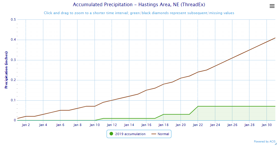 |
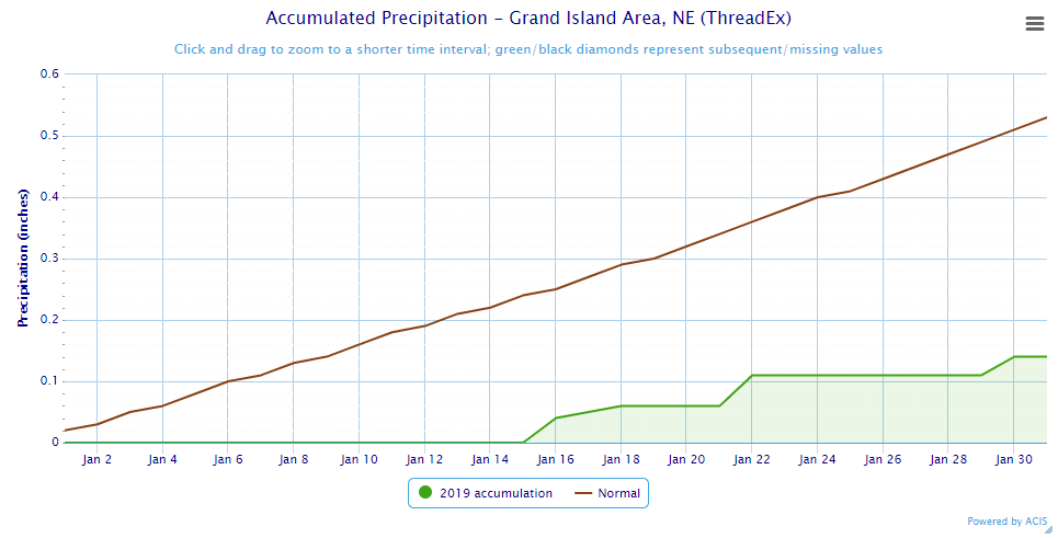
| Grand Island Precipitation Summary: The green line indicates cumulative observed precipitation for January 2019.The brown line indicates "normal" January precipitation based on 30-year data from 1981-2010. (click to enlarge) | Hastings Precipitation Summary: The green line indicates cumulative observed precipitation for January 2019. The brown line indicates "normal" January precipitation based on 30-year data from 1981-2010. (click to enlarge) |
| Grand Island (Regional Airport ASOS) - Feb. 2018 - Jan. 2019 | ||||||||||||
| Feb. | Mar. | Apr. | May | June | July | Aug. | Sept. | Oct. | Nov. | Dec. | Jan. | |
| Average High (F) | 33.6 | 51.8 | 55.4 | 78.6 | 88.2 | 85.8 | 84.3 | 77.4 | 61.3 | 45.9 | 39.5 | 36.4 |
| Average Low (F) | 12.5 | 28.8 | 30.8 | 55.5 | 64.8 | 64.6 | 62.5 | 57.4 | 38.1 | 24.2 | 20.2 | 17.5 |
| Average Temperature (F) | 23.1 | 40.3 | 43.1 | 67.0 | 76.5 | 75.2 | 73.4 | 67.4 | 49.7 | 35.0 | 29.9 | 27.0 |
| Departure From Normal | -6.0 | +0.9 | -7.5 | +5.8 | +5.2 | -1.0 | -0.6 | +2.3 | -2.5 | -3.1 | +3.2 | +1.9 |
| Precipitation (in) | 0.75 | 1.26 | 1.26 | 3.98 | 4.61 | 3.58 | 2.67 | 2.49 | 2.88 | 1.69 | 3.44 | 0.14 |
| Departure From Normal | +0.07 | -0.54 | -1.27 | -0.43 | +0.31 | +0.18 | -0.45 | +0.26 | +1.02 | +0.52 | +2.81 | -0.39 |
| Snowfall (in) | 10.6 | 0.4 | 4.1 | 0.0 | 0.0 | 0.0 | 0.0 | 0.0 | 1.5 | 7.9 | 4.2 | 1.6 |
| Departure From Normal | +4.3 | -5.0 | +2.6 | 0.0 | 0.0 | 0.0 | 0.0 | -0.1 | +0.5 | +4.8 | -0.9 | -4.9 |
| Hastings (Municipal Airport ASOS) - Feb. 2018 - Jan. 2019 | ||||||||||||
| Feb. | Mar. | Apr. | May | June | July | Aug. | Sept. | Oct. | Nov. | Dec. | Jan. | |
| Average High (F) | 34.3 | 52.3 | 55.6 | 78.2 | 87.0 | 85.5 | 83.3 | 76.4 | 60.9 | 46.3 | 39.9 | 37.0 |
| Average Low (F) | 12.4 | 27.8 | 30.6 | 55.6 | 65.0 | 65.1 | 63.1 | 58.2 | 38.7 | 24.9 | 21.9 | 19.4 |
| Average Temperature (F) | 23.4 | 40.1 | 43.1 | 66.9 | 76.0 | 75.3 | 73.2 | 67.3 | 49.8 | 35.6 | 30.9 | 28.2 |
| Departure From Normal | -6.5 | +0.2 | -7.6 | +5.6 | +4.2 | -1.8 | -1.1 | +1.7 | -2.8 | -3.1 | +3.3 | +2.2 |
| Precipitation (in) | 0.53 | 1.07 | 1.26 | 3.83 | 5.91 | 2.19 | 4.40 | 3.69 | 3.04 | 1.52 | 3.13 | 0.07 |
| Departure From Normal | +0.04 | -0.72 | -1.30 | -0.74 | +2.11 | -1.55 | +1.10 | +1.13 | +1.05 | +0.23 | +2.52 | -0.34 |
| Snowfall (in) | 8.0 | 0.3 | 6.9 | 0.0 | 0.0 | 0.0 | 0.0 | 0.0 | 1.1 | 5.5 | 4.3 | 0.9 |
| Departure From Normal | +1.5 | -4.9 | +5.7 | 0.0 | 0.0 | 0.0 | 0.0 | -0.2 | +0.1 | +2.9 | -1.8 | -5.1 |
Kearney - 12 Month Climate History:
All data here is from the official NWS observer at Kearney airport, with 24-hour observations taken around 7 a.m. ** PLEASE NOTE: This official Kearney data often differs slightly from the unofficial data recorded by the automated airport system (KEAR) **
| Kearney Airport (Coop Observer) - Feb. 2018 - Jan. 2019 | ||||||||||||
| Feb. | Mar. | Apr. | May | June | July | Aug. | Sept. | Oct. | Nov. | Dec. | Jan. | |
| Average High (F) | 32.9 | 51.9 | 53.8 | 75.9 | 86.6 | 84.6 | 82.3 | 77.6 | 59.0 | 45.2 | 37.5 | 34.7 |
| Average Low (F) | 10.6 | 26.1 | 28.6 | 52.7 | 62.9 | 63.0 | 59.9 | 55.8 | 35.7 | 22.6 | 18.4 | 17.1 |
| Average Temperature (F) | 21.7 | 39.0 | 41.2 | 64.3 | 74.7 | 73.8 | 71.1 | 66.7 | 47.3 | 33.9 | 28.0 | 25.9 |
| Departure From Normal | -6.4 | +1.3 | -7.5 | +4.8 | +4.9 | -0.9 | -1.5 | +3.2 | -3.6 | -3.1 | +2.1 | +1.3 |
| Precipitation (in) | 0.73 | 1.05 | 2.03 | 5.56 | 2.87 | 6.07 | 2.05 | 1.85 | 3.50 | 0.85 | 3.49 | 0.23 |
| Departure From Normal (in) | +0.18 | -0.74 | -0.20 | +1.38 | -1.06 | +2.79 | -1.03 | -0.22 | +1.46 | -0.17 | +2.92 | -0.26 |
| Snowfall (in) | 9.2 | 0.7 | 9.7 | 0.0 | 0.0 | 0.0 | 0.0 | 0.0 | 1.4 | 5.7 | 8.7 | 1.5 |
| Departure From Normal (in) | +4.1 | -3.9 | +7.9 | 0.0 | 0.0 | 0.0 | 0.0 | -0.2 | +0.7 | +2.6 | +5.2 | -2.9 |
Ord - 12 Month Climate History:
All snowfall data is from the NWS Cooperative Observer in town. In addition, winter precipitation totals often include Cooperative Observer data given that the automated airport equipment is not designed to accurately melt snowfall liquid equivalent (in most cases).
| Ord (Evelyn Sharp Field ASOS) - Feb. 2018 - Jan. 2019 | ||||||||||||
| Feb. | Mar. | Apr. | May | June | July | Aug. | Sept. | Oct. | Nov. | Dec. | Jan. | |
| Average High (F) | 31.2 | 49.9 | 54.1 | 75.4 | 84.0 | 84.0 | 82.2 | 75.4 | 59.5 | 45.3 | 38.6 | 36.5 |
| Average Low (F) | 9.0 | 25.5 | 27.3 | 51.8 | 60.8 | 62.0 | 59.1 | 54.5 | 33.6 | 20.2 | 14.5 | 15.9 |
| Average Temperature (F) | 20.1 | 37.7 | 40.7 | 63.6 | 72.4 | 73.0 | 70.6 | 65.0 | 46.5 | 32.8 | 26.6 | 26.2 |
| Departure From Normal | -7.7 | 0.0 | -8.1 | +4.3 | +3.2 | -1.4 | -2.4 | +1.4 | -3.1 | -3.5 | +1.7 | +1.6 |
| Precipitation (in) | 0.53 | 0.62 | 1.47 | 4.38 | 7.57 | 5.84 | 2.57 | 1.53 | 2.47 | 0.91 | 3.09 | 0.12 |
| Departure From Normal (in) | +0.09 | -0.83 | -1.12 | +0.57 | +3.45 | +2.87 | -0.59 | -0.91 | +0.54 | -0.16 | +2.50 | -0.25 |
| Snowfall (in) | 8.6 | 1.1 | 10.1 | 0.0 | 0.0 | 0.0 | 0.0 | 0.0 | 0.3 | 3.8 | 10.5 | 2.4 |
| Departure From Normal (in) | +2.6 | -4.8 | +7.6 | 0.0 | 0.0 | 0.0 | 0.0 | 0.0 | -0.8 | -1.5 | +3.1 | -4.4 |
Smith Center, KS - 12 Month Climate History:
All data is from the official NWS observer, with 24-hour observations taken around 7 a.m. As a result, data may vary slightly from true "Calendar Day".
| Smith Center KS (NWS Coop Observer) - Feb. 2018 - Jan. 2019 | ||||||||||||
| Feb. | Mar. | Apr. | May | June | July | Aug. | Sept. | Oct. | Nov. | Dec. | Jan. | |
| Average High (F) | 39.4 | 57.8 | 58.4 | 82.7 | 92.2 | 90.7 | 86.9 | 80.9 | 62.5 | 48.6 | 41.1 | 37.4 |
| Average Low (F) | 13.5 | 27.9 | 29.6 | 55.6 | 63.9 | 65.5 | 62.5 | 57.6 | 38.5 | 24.4 | 20.3 | 18.8 |
| Average Temperature (F) | 26.4 | 42.8 | 44.0 | 69.1 | 78.0 | 78.1 | 74.7 | 69.3 | 50.5 | 36.5 | 30.7 | 28.1 |
| Departure From Normal | -5.6 | +1.2 | -8.5 | +5.4 | +4.0 | -1.6 | -2.5 | +1.1 | -4.3 | -3.9 | +1.9 | +0.4 |
| Precipitation (in) | 0.31 | 1.05 | 0.91 | 2.62 | 6.33 | 3.98 | 3.25 | 3.88 | 4.61 | 0.62 | 3.61 | 0.42 |
| Departure From Normal (in) | -0.27 | -0.82 | -1.36 | -1.30 | +2.72 | +0.11 | -0.05 | +1.84 | +2.73 | -0.60 | +2.95 | -0.07 |
| Snowfall (in) | 7.6 | T | 2.0 | 0.0 | 0.0 | 0.0 | 0.0 | 0.0 | 1.2 | 5.8 | 2.4 | 7.0 |
| Departure From Normal (in) | +3.5 | -2.6 | +1.4 | 0.0 | 0.0 | 0.0 | 0.0 | -0.2 | +0.8 | +4.0 | -0.8 | +3.3 |
Temperature & Precipitation Departure From Normal Maps:
These images depict January 2019 monthly temperature departure from normal & precipitation percent-of-normal for both Nebraska & Kansas. Images are courtesy of the High Plains Regional Climate Center (HPRCC). Please note: These maps occasionally contain "bullseyes" of errant data. For precipitation, you can also generate departure from normal/percent-of-normal maps using the NWS AHPS page, or view local-area images generated each day by NWS Hastings.
 |
 |
 |
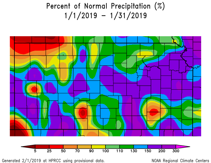 |
| Departure from Normal Temperature - NE (left) & KS (right) | Percent of Normal Precipitation - NE (left) & KS (right) | ||
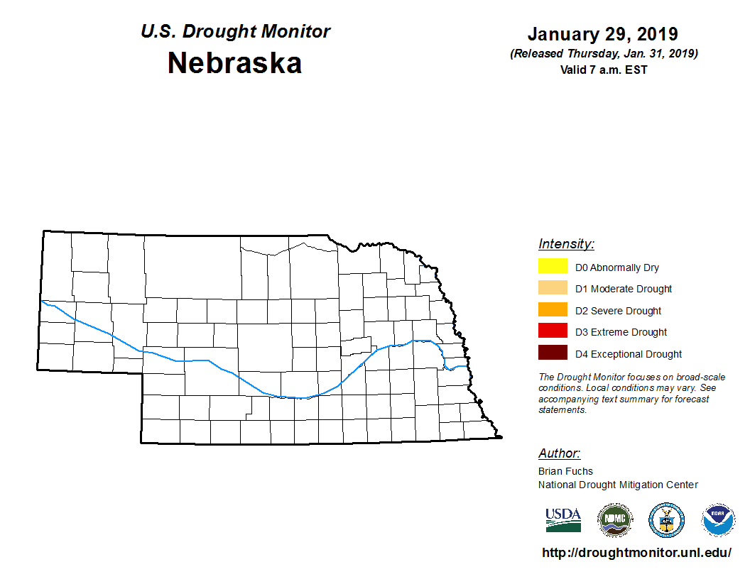
Drought:
The following drought images, current as of January 29, 2019, are courtesy of the U.S. Drought Monitor
Summary of changes during January 2019 across the NWS Hastings coverage area:
Despite below average precipitation across roughly the northwest 2/3 of the local area, the lingering effects of WELL ABOVE normal precipitation during December kept the ENTIRE NWS Hastings coverage area void of all drought categories during January 2019.
 |
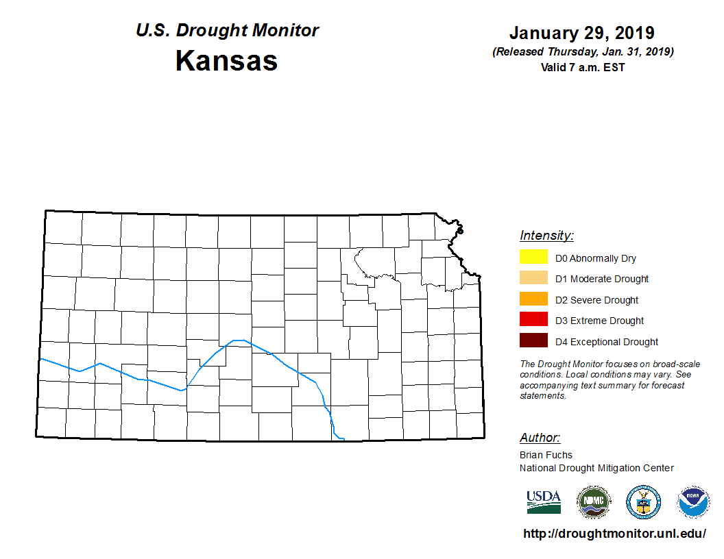 |
| Drought Monitor for Nebraska (left) & Kansas (right). Valid as of January 29, 2019 (click to enlarge) | |
January 2019 Extremes for the NWS Hastings Coverage Area:
...SOME OF THE WARMEST HIGH TEMPERATURES DURING JANUARY 2019...
(all data from NWS cooperative observers or automated airport sites, with the date it actually occurred indicated in parentheses)
63 degrees...Plainville KS 4WNW (5th)
62 degrees...Hebron (5th)
61 degrees...Smith Center KS (5th)
60 degrees...Franklin (5th) - Burr Oak KS (5th)
59 degrees...Beloit KS (5th) - Clay Center (5th) - Beaver City (27th)
...SOME OF THE COLDEST LOW TEMPERATURES DURING JANUARY 2019...
(all data from NWS cooperative observers or automated airport sites, with the date it actually occurred indicated in parentheses)
-12 degrees...Osceola (30th)
-9 degrees...Greeley (30th) - York 3N (30th)
-8 degrees...Aurora airport (30th) - York airport (30th) -
-6 degrees...Loup City (30th) - Ord airport (30th) - Grand Island airport (30th) - Geneva (30th)
...SOME OF THE HIGHEST MONTHLY PRECIPITATION TOTALS DURING JANUARY 2019...
(all data from NWS cooperative observers and CoCoRaHS/NeRAIN observers unless indicated)
1.49"...Natoma KS (7NNE)
1.31"...Hunter KS (2NNW)
1.19"...Hebron
1.13"...Shickley (4S)
1.12"...Tobias (2WSW)
1.09"...Plainville (4WNW)
1.05"...Davenport (6SE)
1.03"...Beloit KS
1.00"...Cawker City KS
...SOME OF THE LOWEST MONTHLY PRECIPITATION TOTALS DURING JANUARY 2019...
(all data from NWS cooperative observers and CoCoRaHS/NeRAIN observers unless indicated)
0.03"...Lexington (1E)
0.04"...Doniphan
0.06"...Hastings NWS office - Loup City - Osceola - Scotia (4E)
0.07"...Hastings airport - Arcadia
0.08"...Belgrade - Minden - Oxford (6NNW)
...SOME OF THE HIGHEST MONTHLY SNOWFALL TOTALS DURING JANUARY 2019...
(all data from NWS cooperative observers and CoCoRaHS/NeRAIN observers unless indicated)
12.3"...Tobias (2WSW)
12.0"...Hebron
11.0"...Hubbell
10.6"...Plainville KS (4WNW) - Davenport (6SE)
10.0"...Natoma KS (7NNE) - Webber KS (3ENE)
9.8"...Stockton KS (10WNW)
9.3"...Hunter KS (2NNW)
9.0"...Beloit KS - Shickley (4S)
 |
Media use of NWS Web News Stories is encouraged! Please acknowledge the NWS as the source of any news information accessed from this site. |
|